Introduction
Deserts are not just hot, sandy places. They are regions defined by extremely low rainfall and limited vegetation. While many deserts lie near 30° north and south due to global air circulation, they can also form in coastal areas, rain shadows, continental interiors, and even polar regions. Understanding where deserts are located helps explain how climate, geography, and atmospheric patterns shape the Earth.
Overview: What Makes a Place a Desert?
A desert is usually described as a large area that receives very little precipitation. The exact measurement can vary slightly depending on the source, but the standard idea is consistent: a place becomes a desert when it is too dry to support dense vegetation. National Geographic commonly describes deserts as places that receive less than 10 inches, or 25 centimeters, of rain per year, while USGS and other scientific sources use a similar annual precipitation threshold of about 250 millimeters.
That definition is important because it shows that deserts are not defined by heat. Heat and dryness are not the same thing. A region can be cold and still be a desert if it receives almost no moisture. That is why Antarctica is classified as a desert even though it is covered in ice. It is also why the Gobi can be a desert even though it can have freezing winters and snow.
Deserts can appear in many forms:
- Hot deserts with intense sunlight and high daytime temperatures
- Cold deserts with low temperatures and limited moisture
- Coastal deserts where ocean currents suppress rainfall
- Interior deserts far from oceanic moisture
- Rain shadow deserts on the dry side of the mountains
- Polar deserts in the Arctic and Antarctica
This broad range of desert types matters because it prevents us from reducing deserts to a single visual stereotype. Drylands are diverse, dynamic, and geographically spread across the Earth.
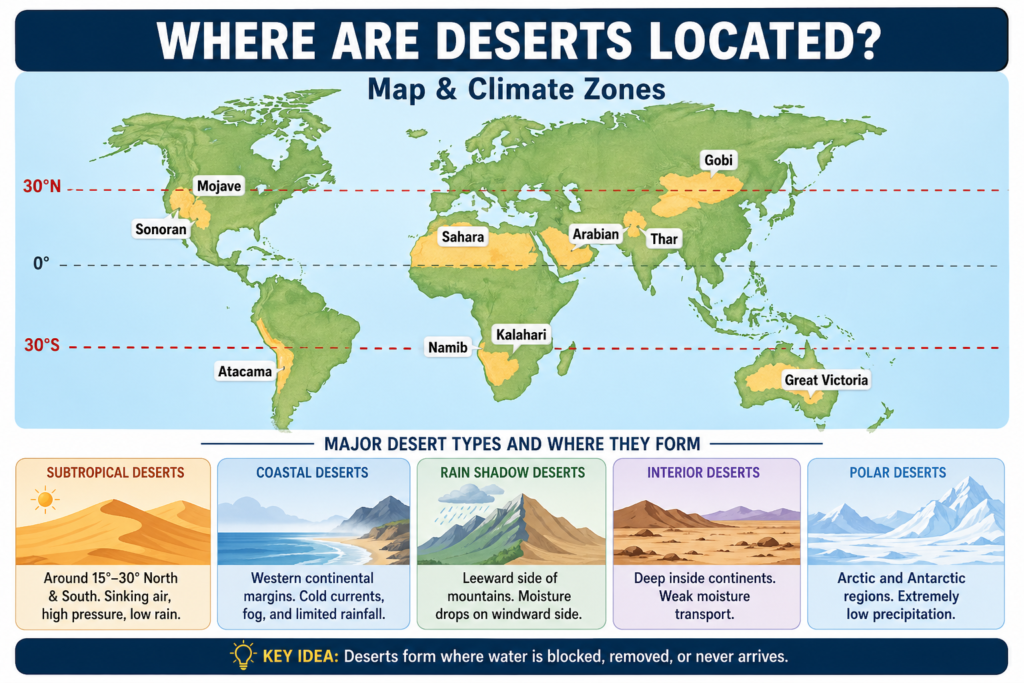
Where Are Deserts Located on Earth?
The most recognizable desert pattern is the broad subtropical desert belt. This belt circles the globe near 30 degrees north and 30 degrees south, where high-pressure systems and sinking air reduce cloud formation and rainfall. NOAA explains that these horse latitude zones are associated with calm winds, descending air, and stable conditions that limit precipitation. Britannica also places many tropical and subtropical deserts in this general latitude range.
That is why huge deserts appear in places such as:
- Northern Africa
- The Arabian Peninsula and surrounding regions
- Southern Africa
- Australia
- The southwestern United States and northern Mexico
- Parts of South America
These desert belts do not appear randomly. They are part of the planet’s atmospheric circulation. Warm air rises near the equator, drops moisture as rain, and then moves poleward before sinking in the subtropics. When air sinks, it warms and becomes drier, which makes rain less likely. This is one of the main reasons deserts concentrate near 30° latitude.
Still, deserts are not limited to that band. USGS explains that deserts can also form as coastal deserts, rain shadow deserts, midlatitude deserts, interior deserts, and polar deserts. So when someone asks where deserts are located, the best answer is not a single line on a map. It is a combination of latitude, topography, atmospheric movement, and moisture access.
In simple terms, deserts occur wherever the climate system blocks, removes, or fails to deliver enough water.
Why Are Many Deserts Found Near 30° North and South?
The reason is global atmospheric circulation. Near the equator, warm air rises because the sun heats the surface strongly. That rising air expands, cools, and releases moisture as rainfall. After that, the air travels high in the atmosphere toward the subtropics. Around 30° north and south, that air sinks back down.
Sinking air creates conditions that are bad for rain. As it descends, it compresses and warms. Warm air can hold more moisture, so clouds are less likely to form. Fewer clouds mean more sunlight reaches the ground, and more sunlight means more evaporation. The result is a dry climate with limited rainfall.
That is why deserts are often aligned in a broad ring around the planet rather than appearing in random, isolated patches. This is also why so many famous deserts share similar latitude positions even though they are Separated by oceans and continents. The Sahara, the Arabian Desert, the Sonoran Desert, parts of the Atacama, and many Australian deserts all fit this larger atmospheric pattern.
So the answer to where deserts are located is deeply linked to planetary circulation. The wind belts of Earth help write the map of desert distribution.
How Deserts Form: The Main Location Patterns
Deserts form through several major geographic and climatic patterns. These patterns are useful because they show why deserts can appear in very different environments.
1. Subtropical high-pressure deserts
These deserts form near 30° latitude, where air sinks and rainfall remains scarce. They are among the most common deserts on Earth.
2. Coastal deserts
These deserts develop near oceans, especially along western continental margins, where cold ocean currents and stable air reduce rainfall. Fog may be common, but rain is rare.
3. Rain shadow deserts
These deserts form on the leeward side of mountains. Moist air rises over the mountains, cools, releases precipitation, and then descends on the other side as dry air.
4. Interior deserts
These deserts sit deep inside continents where moisture loses strength before reaching the center of landmasses. Distance from the ocean plays a major role here.
5. Polar deserts
These deserts occur in the Arctic and Antarctic, where temperatures are very low, and precipitation is minimal. They are dry even though they are cold.
These categories show that desert location is a result of climate architecture. A desert is not simply “a hot,t dry place.” It is a specific environmental outcome created by circulation, elevation, position, and moisture pathways.
Quick Table: Desert Type and Where It Usually Forms
| Desert type | Typical location | Main climate clue | Example |
| Subtropical desert | Around 15°–30° north and south | Sinking air, high pressure, low rain | Sahara, Arabian Desert |
| Coastal desert | Western continental margins | Cold currents, fog, and limited rainfall | Atacama, Namib |
| Rain shadow desert | Leeward side of the mountains | Moisture drops on the windward side | Interior dry basins |
| Interior desert | Deep inside continents | Weak moisture transport | Gobi, Great Basin |
| Polar desert | Arctic and Antarctic regions | Extremely low precipitation | Antarctica, High Arctic dry zones |
This table makes it easier to see that deserts are tied to position, circulation, and terrain rather than to sand alone.
Desert Climate Zones: Hot, Cold, Coastal, Interior, and Polar
Not all deserts fit the same thermal profile. Climate zones help explain why one desert feels completely different from another.
Hot deserts
Hot deserts are the version most people imagine first. They usually occur in subtropical zones and experience very intense sunlight, low humidity, and high daytime heat. The Sahara is the best-known example. Its dunes and open expanses have become a global symbol of desert landscapes, but it is only one type of desert environment.
Cold deserts
Cold deserts are dry but not hot. They may receive very little precipitation, yet their temperatures stay low for much of the year. The Gobi Desert and the Great Basin are well-known examples. In these regions, winter cold, elevation, or continental position keeps temperatures down even as precipitation remains scarce.
Coastal deserts
Coastal deserts are found near oceans but remain dry. This happens because cold currents cool the air and suppress rain. The Atacama and Namib are classic examples. These are especially interesting because they show that proximity to water does not guarantee rainfall.
Interior deserts
Interior deserts sit far from moist air sources. By the time air masses travel across an entire continent, much of their moisture is already gone. Large inland deserts in Asia, North America, and Australia are often shaped by this pattern.
Polar deserts
Polar deserts are dry because the air is too cold to hold much moisture and because precipitation is extremely limited. Antarctica is the most famous example. It is frozen, windy, and dry at the same time, which makes it one of the clearest reminders that deserts are defined by precipitation, not temperature.
Major Desert Regions by Continent
A continent-by-continent breakdown is one of the most practical ways to understand where deserts are located. It makes the global pattern easier to visualize and remember.
Africa
Africa contains some of the most important and expansive desert regions in the world. The most famous is the Sahara, which is the largest hot desert on Earth. It covers a massive portion of northern Africa and spans many countries. Britannica describes it as stretching across much of the northern part of the continent, making it one of the most dominant geographic features in the world.
Africa also has the Namib Desert, which lies along the southwest coast. This desert is strongly linked to coastal dryness and cold ocean influences. It is known for extreme aridity, dramatic dunes, and striking landscapes. The Kalahari Desert in southern Africa is another major dry region, though it is more semiarid in parts than the Sahara or Namib.
Africa is a useful continent for desert study because it contains multiple desert types in one landmass. You can see subtropical aridity, coastal dryness, and semiarid interior conditions all within the same broad region. That makes Africa a powerful example when answering where deserts are located and why.
The Sahara is especially useful for geography readers because it stretches across several countries, including Morocco, Algeria, Tunisia, Libya, Egypt, Mauritania, Mali, Niger, Chad, and Sudan. That wide distribution shows how a desert can be enormous enough to cross national borders and remain a unified climate zone.
Asia
Asia is home to several major desert systems, including the Arabian Desert, Gobi Desert, Taklamakan Desert, and Thar Desert. These deserts are important because they represent different formation mechanisms and different climate conditions.
The Arabian Desert is one of the most prominent subtropical deserts in the world. It fits the descending-air model of desert formation and occupies a huge portion of the Arabian Peninsula. It is dry, expansive, and strongly associated with the subtropical dry belt.
The Gobi Desert is a very different environment. Britannica describes it as a cold desert that stretches across parts of Mongolia and China. It is not just sand; much of it is rocky, barren, or gravelly. That makes it a great example of how desert terrain can be harsh without being sandy.
The Taklamakan Desert in western China is another major inland desert. Its dry climate is shaped by its remote continental position and surrounding mountain systems. The Thar Desert in India and Pakistan is also important because it exists in a region influenced by monsoon dynamics, which shows that desert climates can coexist with seasonal precipitation systems.
Asia demonstrates the full variety of desert geography. It includes hot deserts, cold deserts, high-altitude drylands, and interior basins that receive very little moisture. Anyone studying where deserts are located will find Asia one of the most instructive continents.
North America
North America includes several major desert regions, especially in the southwestern United States and northern Mexico. The best known are the Mojave Desert, Sonoran Desert, Chihuahuan Desert, and Great Basin Desert.
USGS classifies the Mojave, Sonoran, and Chihuahuan as hot deserts, while the Great Basin is a cold desert. This distinction is important because it shows that the desert location in North America is not uniform. Some deserts are shaped by subtropical dryness, while others are influenced by elevation and continental position.
The Great Basin Desert is especially useful for students because it is a high-elevation inland desert. Its climate is colder than the classic hot desert image, yet it still qualifies as a desert because of its low precipitation. The Mojave Desert is closely associated with very hot conditions and is often used in discussions of desert landscapes in the American West. The Sonoran Desert and Chihuahuan Desert each have their own ecological character, but both fit within the dryland structure of the region.
North America is a perfect example of how a desert location depends on more than one factor. Latitude matters, but so do elevation, rain shadows, and distance from ocean moisture.
South America
South America’s most famous desert is the Atacama Desert in northern Chile. It is one of the driest nonpolar deserts on Earth and is often used as the classic example of a coastal desert. Its extreme dryness comes from a combination of cold ocean influence, atmospheric stability, and mountain barriers.
The Atacama is especially striking because it lies near the ocean yet still receives very little rainfall. That alone proves that a coastline does not always mean a wet climate. In this case, the ocean helps create fog in some areas, but not enough rainfall to erase the desert conditions.
South America also includes the broad dry and semiarid regions of Patagonia. Britannica describes Patagonia as a vast semiarid plateau, which means it is not a pure sand desert but still belongs to the larger dryland family. Together, the Atacama and Patagonia show that South America contains both extreme aridity and broader semiarid terrain.
This continent is useful because it highlights coastal dryness and continental drylands in one region. It helps readers understand that desert location is not based only on visible dunes but on water balance and climate behavior.
Australia and Oceania
Australia is one of the world’s most desert-connected continents. Britannica identifies the Great Victoria Desert as Australia’s largest desert. National Geographic also notes that more than one-fifth of Australia is covered in desert, which makes the continent one of the most arid in the world.
Australia’s deserts are strongly linked to its broad subtropical position, interior dryness, and limited moisture access across large land areas. Many parts of the continent are far from reliable rainfall sources, which helps explain why so much of the interior is dry. These conditions produce vast desert zones, dry shrublands, and arid basins.
Australia is especially valuable in a discussion about where deserts are located because it shows how one continent can contain expansive desert systems that dominate the landscape. It also demonstrates that deserts are not rare exceptions but major geographic features in some regions.
In Oceania, dryland conditions may also appear in certain islands and interior environments, though Australia remains the region’s dominant desert powerhouse.
Europe
Europe does not have large desert coverage compared with Africa, Asia, or Australia, but it does have a notable example: the Tabernas Desert in Spain. National Geographic identifies it as Europe’s only desert.
This matters because it expands the reader’s concept of desert geography. Deserts are not only found in the large dry belts of Africa or Asia. They can also appear in localized regions where terrain, rainfall patterns, and regional climate combine to produce arid conditions.
The Tabernas Desert is important in geography education because it shows that deserts can exist in places that do not match the stereotype of vast tropical heat. It also proves that desert conditions may emerge from a precise combination of local climate and landform factors.
Antarctica
Antarctica is one of the most essential examples in any article about desert locations. It is often surprising to people, but it is a desert because it receives extremely little precipitation. Britannica describes Antarctica as the driest, coldest, windiest, and iciest continent. That combination makes it one of the harshest environments on Earth.
Under precipitation-based definitions, Antarctica is the largest desert on Earth. National Geographic and Britannica both support this classification. It may look nothing like a classic sand desert, but it still fits the scientific definition perfectly because moisture is so scarce.
This is one of the most powerful examples of showing why deserts are not defined by heat. Antarctica makes it clear that dryness, not temperature, is the key criterion.
Why Deserts Can Be Hot, Cold, Rocky, or Icy
A desert is not a single visual category. It is a moisture category. That means the same climate rule can create completely different landscapes depending on location and environmental conditions.
A desert can be hot because it sits under sinking subtropical air. Cold conditions occur at high latitudes or elevated terrain. Rocky surfaces form where wind strips away finer particles or exposes the underlying geology. Icy environments develop when the air is cold and dry, reducing liquid water and limiting plant growth.
Britannica makes this distinction clear by describing deserts as extremely dry areas with sparse vegetation, while also noting that cold deserts occur in temperate and polar regions. National Geographic likewise reminds readers that deserts can be mountainous or icy. This is a useful correction to the common myth that deserts are always warm and sandy.
The truth is simpler and broader: deserts are dry, and dryness can create many different kinds of landscapes.
The Role of Mountains in Desert Location
Mountains are powerful climate barriers. They can force moist air to rise, cool, and release rain on one side, while leaving the opposite side much drier. This is called the rain shadow effect.
Here is the process in plain language:
- Moist air approaches a mountain range.
- The air rises on the windward slope.
- As it rises, it cools.
- Cooling causes moisture to condense and fall as precipitation.
- After crossing the peak, the air descends.
- Descending air warms and dries out.
- The leeward side receives much less rainfall.
This is one of the strongest reasons deserts appear inland or behind mountain chains. USGS identifies rain shadow deserts as a major desert type. The Gobi is often used as a regional example of this process, as mountain systems help block or reduce moisture reaching the interior.
Mountains, therefore, function like climate gates. They do not create deserts by themselves, but they can sharply reduce rainfall and help establish arid regions.
The Role of Oceans and Cold Currents
Oceans do not always make land wetter. In some places, cold ocean currents help create deserts by reducing evaporation and limiting rain formation. This is especially common on western continental margins near the tropics.
USGS explains that coastal deserts often form where cold currents influence the air above the coast. These currents can produce fog but not enough rainfall. That is why the Atacama Desert and Namib Desert are so dry despite their proximity to the sea.
This is one of the most counterintuitive parts of desert geography. People often assume that being near water means a place must be humid or rainy. Coastal deserts prove the opposite. A coastline can sit beside one of the driest climates on Earth if the ocean-atmosphere system is configured in the wrong way for rainfall.
That is why ocean currents are a major part of answering where deserts are located.
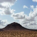
Desert Landscapes: More Than Sand Dunes
A common misunderstanding is that deserts are all dunes. In reality, desert landforms are much more diverse.
Deserts may include:
- Sand seas and dunes
- Gravel plains
- Rocky plateaus
- Salt flats
- Dry basins
- Canyons
- Dry riverbeds
- Stony surfaces
- Mountainous desert terrain
Britannica describes parts of the Gobi as bare rock. USGS also notes that desert surfaces can include rock, gravel, dry basins, and isolated vegetation. National Geographic similarly shows desert regions as varied landscapes rather than uniform sand fields.
This matters because it changes how readers think about desert location. Once a person understands that deserts can be rocky, frozen, foggy, or gravel-covered, it becomes much easier to recognize them on a map and in the field.
Deserts are not empty spaces. They are active land systems shaped by erosion, wind, climate stress, and scarce but powerful water events.
Table: Common Desert Landforms and What They Mean
| Landform | What it looks like | Why does it appear in deserts |
| Dunes | Ridges and waves of sand | Wind moves loose sediment into piles |
| Gravel plains | Flat surfaces covered in stones | Wind removes finer particles |
| Rocky plateaus | Exposed stone and bare rock | Low soil formation and limited weathering |
| Salt flats | White crusty surfaces | Evaporation leaves salt behind |
| Dry valleys | Broad valleys with little water | Extremely low rainfall and weak drainage |
These landforms help reveal how deserts are built by wind, evaporation, and limited water supply.
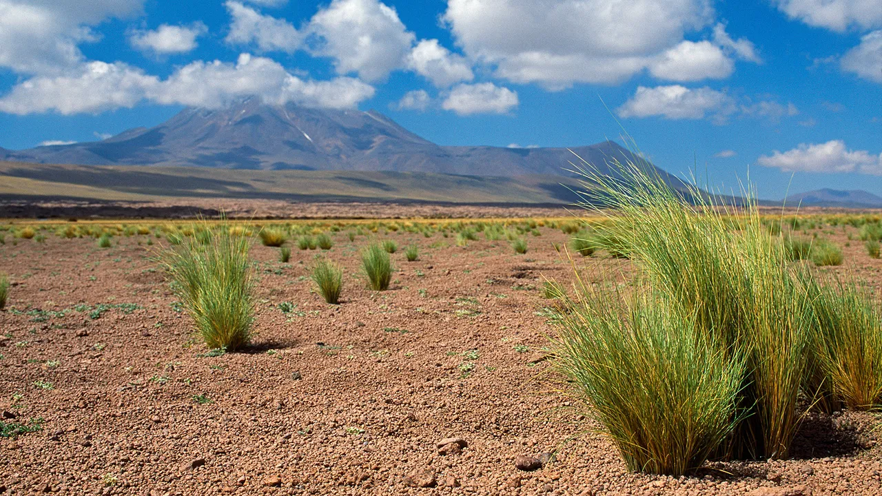
Plants in Desert Regions
Desert plants are highly specialized survivors. They are not fragile by default; they are adapted to limited water. Some plants store moisture in stems, roots, or leaves. Others have small leaves, deep root systems, waxy coatings, or rapid life cycles that let them grow quickly after rainfall.
National Geographic explains that some desert plants conserve water by reducing exposed surface area, while the USGS lists examples such as Joshua trees, ocotillo, saguaro cactus, desert poppies, and bristlecone pines. Britannica also notes that desert vegetation has evolved unusual adaptations to survive irregular precipitation.
In many desert regions, vegetation may be sparse but still highly effective. Plants live in clusters, survive long dry spells, and respond quickly when rain briefly appears. That is one reason deserts should be understood as ecosystems, not wastelands.
Animals That Live in Deserts
Deserts support a remarkable range of animal life. Many species have developed behaviors and physiological features that let them survive heat, dryness, and food scarcity.
USGS lists animals such as desert tortoises, bats, pupfish, kangaroo rats, pronghorn, Gila monsters, bighorn sheep, desert iguanas, and many birds and reptiles as desert-adapted species in the American West. These animals often avoid peak daytime heat, burrow underground, become active at night, or conserve water efficiently.
Desert animals are examples of evolutionary adaptation in action. Some can go long periods without direct water intake. Others get moisture from food. Some use burrows as temperature shelters. Others are built to move quickly across open ground or survive with low energy demands.
This is another reason deserts matter. They are not biologically empty. They are highly specialized habitats.
Human Life in Desert Regions
People have lived in desert regions for thousands of years. Human communities have adapted to dry conditions through migration, trade, water management, architecture, and cultural knowledge. National Geographic and Britannica both describe the long history of human life in desert environments such as the Sahara and Arabian Desert.
Deserts have also played a major role in trade routes. Caravans, oases, and stopping points became essential where water was scarce. This created networks of exchange, movement, and communication across difficult terrain. Desert regions were never just barriers; they were also corridors of human history.
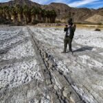
Archaeological preservation is another important point. Dry climates can help preserve bones, tools, texts, and artifacts for long periods because moisture-driven decay is limited. USGS notes that desert conditions can be excellent for preserving fossils and archaeological evidence.
That means a desert location is not only a physical geography topic. It is also a history topic, a cultural topic, and an archaeological topic.
Why Desert Location Matters for Geography Students
The question of where deserts are located is one of the best entry points into climate geography. It teaches how atmospheric circulation works, how mountain ranges affect rainfall, how ocean currents influence coastlines, and how latitude shapes climate zones.
It also helps students understand that climate does not follow a single simple rule. Two places can sit at similar latitudes and have very different precipitation patterns because one is coastal, one is inland, one is high-elevation, or one lies behind a mountain barrier.
A desert location is, therefore, a gateway concept. Once a student understands deserts, they can better understand:
- Global wind belts
- Subtropical highs
- Rain shadows
- Ocean-current influence
- Continental dryness
- Polar climate systems
That makes desert geography a foundational topic rather than a niche one.
The Best Way to Remember Desert Location
A simple memory rule is this: deserts appear where water is blocked, removed, or never arrives.
Water may be blocked by mountain barriers. It may be removed by sinking air and evaporation. It may be weakened by distance from the ocean. Or it may be absent because a region sits under persistent high pressure or in an extremely cold polar environment.
This one idea explains most of the world’s major deserts:
- The Sahara fits subtropical sinking air.
- The Atacama fits cold currents and mountain barriers.
- The Gobi fits the rain shadow and inland dryness.
- The Great Basin fits the elevation and continental position.
- Antarctica experiences extreme cold and low precipitation.
That makes desert geography easier to remember, easier to teach, and easier to visualize on a world map.
Major Desert Examples Readers Should Know
Some desert names are especially useful because they appear often in geography, science, and travel writing.
The Sahara is the largest hot desert in the world and covers most of northern Africa. The Gobi is a major cold desert in Mongolia and China, known for its rocky terrain and harsh winters. The Great Victoria Desert is Australia’s largest desert. The Atacama is one of the driest places on Earth. Antarctica is the largest desert overall under precipitation-based definitions.
These names matter because they represent different desert mechanisms and different climate zones. Knowing them helps a reader build a mental map of global dryness.
Table: Major Desert Regions by Continent
| Continent | Major desert regions | Key fact |
| Africa | Sahara, Namib, Kalahari | Sahara is the largest hot desert |
| Asia | Arabian Desert, Gobi, Taklamakan, Thar | Gobi is a major cold desert |
| North America | Mojave, Sonoran, Chihuahuan, Great Basin | The Great Basin is a cold desert |
| South America | Atacama, Patagonian drylands | Atacama is among the driest |
| Australia/Oceania | Great Victoria Desert and other interior deserts | Australia has extensive desert coverage |
| Europe | Tabernas Desert | Europe’s only widely known desert |
| Antarctica | Antarctic Desert | Largest desert overall by precipitation-based definition |
This table works well as a quick reference for readers who need the geographic overview at a glance.
Common Myths About Desert Location
One of the biggest myths is that deserts are always hot. That is false. The Gobi, the Great Basin, and Antarctica are all dry but cold.
Another myth is that deserts are always made of sand. That is also false. Many deserts are rocky, gravelly, stony, foggy, or icy. Dunes are the only possible desert landform.
A third myth is that deserts are empty or useless. In reality, deserts support diverse ecosystems, unique plants, specialized animals, human cultures, scientific research, tourism, and historical preservation. They are not blank spaces. They are living landscapes with ecological and cultural value.
Correcting these myths makes it easier to understand the real question behind where deserts are located: the Earth has many kinds of dry zones, not just one dramatic image.
Environmental Problems in Desert Regions
Desert ecosystems are fragile. They often recover slowly from disturbance because water is limited and plant growth is slow. USGS warns that desert landscapes can be damaged for long periods by roads, mining, overgrazing, pollution, invasive species, and urban expansion.
Another major issue is desertification. National Geographic describes desertification as the process by which human activity turns semiarid land into drier, more desert-like land. That is different from a natural desert forming through climate patterns. Desertification is a land-degradation process, not just a climate category.
This distinction is important because it shows that deserts are not only natural features. Human activity can expand dry conditions, intensify ecological stress, and make already fragile lands even more vulnerable.
Travel and Tourism in Desert Areas
Deserts attract travelers because they offer enormous horizons, striking landforms, rare wildlife, and some of the clearest night skies on Earth. People visit deserts for hiking, photography, stargazing, geology, wildlife viewing, film history, and cultural exploration.
The Atacama is famous for its clear skies and observatories. The Tabernas Desert in Spain is linked to film production and landscape tourism. Other deserts are visited for their dunes, archaeological sites, or remote wilderness experiences.
Travel in deserts, however, must be approached carefully. Water, navigation, shade, and heat awareness are essential. A desert may look quiet and open, but it can still be dangerous because temperatures, distances, and dehydration risks can escalate quickly.
That is another reason desert location matters. Knowing where deserts are found helps travelers understand what kind of conditions to expect.
FAQs
Most hot deserts are located near 30° north and south of the equator, but deserts also appear in coastal areas, rain shadows, continental interiors, and polar regions. NOAA, USGS, and Britannica all support this global pattern.
Because air sinks in the subtropics, creating high-pressure, stable conditions and low rainfall. This atmospheric pattern is the main reason many deserts cluster in that latitude band.
No. Deserts can be cold, rocky, gravelly, coastal, mountainous, foggy, or icy. Antarctica is the clearest example of a cold desert, and the Gobi shows that deserts can also be rocky and severe.
Under precipitation-based definitions, Antarctica is the largest desert on Earth. The Sahara is the largest hot desert.
Yes. Human communities have lived in deserts for thousands of years. More than a billion people live in desert and dryland regions, using adapted water, settlement, and livelihood strategies.
The Atacama Desert is widely recognized as one of the driest nonpolar deserts on Earth. It is often discussed as a classic example of extreme coastal aridity.
Conclusion
Deserts form wherever moisture is scarce, whether in hot subtropical zones, cold polar regions, or dry inland areas. Air circulation, mountains, oceans, and distance from water sources shape their locations. By Understanding these patterns, it becomes clear that deserts are not random—they are a key part of Earth’s climate system.