Introduction
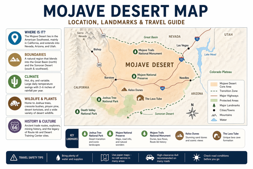
A Mojave Desert map helps readers understand more than location. It shows where the desert sits in the American Southwest, how its edges blend into nearby desert regions, and which landmarks matter most for travel and study. Because the Mojave is a transition zone, different maps may show slightly different boundaries. That is why an accurate, map-first guide is useful for anyone planning a trip or learning about the region.
What a Mojave Desert map really shows
A strong Mojave Desert map does not merely display empty desert space. It communicates terrain transitions, public lands, highways, protected areas, elevation change, trail access, and practical travel points. That is important because the Mojave is a natural region, not a political shape. Its outer edges are gradual, especially where it meets the Great Basin to the north and the Sonoran Desert to the south and southeast.
A useful map also teaches scale. The Mojave covers more than 25,000 square miles, and Britannica notes that it spans portions of California, Nevada, Arizona, and Utah. Because of that size, not every Mojave map serves the same purpose. Some maps emphasize ecology. Others prioritize driving access. Others are built for hiking, park visits, land management, or historical interpretation. The same region can be represented in different ways depending on the user’s intent.
A student may want the Mojave as a broad ecological system. A traveler may want fuel stops, highway corridors, and preserve entrances. A hiker may want trailheads, washes, and boundary markers. A well-built pillar article should handle all of those user intents without turning the topic into confusion.
That is also why official resources matter. The NPS Mojave National Preserve map page and road conditions page exist for practical planning, not just aesthetics. The desert is visually compelling, but it is also logistically demanding. A map should help people move through it safely, not simply admire it from afar.
Where the Mojave Desert is located
The Mojave Desert location is easiest to understand as a broad inland desert region in the southwestern United States. Britannica describes it as lying mainly in California while extending into Nevada, Arizona, and Utah. It runs from the Sierra Nevada to the Colorado Plateau and connects to surrounding desert systems at its outer margins.
The most useful mental image is simple: look east of the Sierra Nevada, west of the Colorado Plateau, and across inland southern California and southern Nevada. That is the core landscape most people mean when they refer to a Mojave Desert map. The region also includes major reference points such as Death Valley, Lake Mead, and Joshua Tree National Park. Britannica places Death Valley near the undefined Great Basin–Mojave border, while the Colorado River and Lake Mead sit near the eastern edge of the desert system.
State-by-state reach
The Mojave is mostly a California desert, but not only a California desert. Britannica describes it as a region centered in California with extensions into Nevada, Arizona, and Utah. This matters because desert geography does not respect state borders. Counties, highways, and administrative lines are useful for governance, but they do not define the desert itself. A smart map has to reflect that natural geography rather than flatten it into state boundaries.
Why do the boundaries look different on different maps?
The Mojave Desert does not have a perfectly fixed border because it is a transition zone. Britannica explains that it blends into the Great Basin in the north and the Sonoran Desert to the south and southeast. Joshua Tree National Park is a well-known example of this transition, since the National Park Service says the park is where the Mojave and Colorado deserts meet.
This is why ecological maps, travel maps, and public-lands maps often show slightly different edges. An ecology map may follow vegetation patterns and species ranges. A travel map may emphasize roads, fuel, and access. A park map may focus only on one preserve or monument. The boundary changes because the purpose changes, not because the desert suddenly ends.
Quick geography reference
| Map feature | What it shows | Why it matters |
| Sierra Nevada and the western mountain edge | The western frame of the desert and its rain-shadow setting | Helps explain why the Mojave is dry and where the desert begins visually |
| Great Basin transition zone | A northern edge that gradually shifts rather than stopping sharply | Shows why maps may differ slightly in how they draw the boundary |
| Sonoran transition zone | The southern and southeastern edge | Explains why nearby desert areas can feel ecologically different |
| Joshua Tree National Park | A famous meeting point of desert ecosystems | A major anchor for readers trying to understand the regional transition |
| Mojave National Preserve | A major public-land travel anchor | Offers official maps and current conditions for visitors |
| Mojave Trails National Monument | A corridor of geology, history, and Route 66 travel | Connects landscape, culture, and road history |
Climate and weather patterns
The Mojave Desert climate is hot, dry, and variable. Britannica describes the desert as having large daily temperature swings, frequent winter frosts, and average annual precipitation of roughly 2 to 6 inches. That means the Mojave is not simply “hot all the time.” The climate changes by hour, by season, by elevation, and by landform.
This matters when someone reads a Mojave Desert map for travel. A road that looks easy on a screen can become risky after dark, during wind, or after a storm. In desert terrain, weather is part of navigation. The NPS road conditions page warns that conditions change and that mobile navigation can fail in the preserve. The BLM gives the same warning for Mojave Trails National Monument.
The Mojave also experiences strong rain-shadow effects. USGS explains this clearly for Joshua Tree National Park: moist air moves inland from the Pacific, mountains push it upward, and much of the moisture drops before the air reaches the desert side. The result is arid land, intense temperature contrast, and flash-flood risk when storms do arrive.
What this means for readers
A map user should never treat the Mojave as one flat, uniform space. Low basins, mountain fronts, dune fields, and higher zones each have distinct microclimates. That is why one portion of the desert may support Joshua trees and creosote while another supports pinyon pine and juniper in cooler, higher terrain.
This climate layering is part of the desert’s identity. It shapes what grows there, what lives there, where roads are built, and how safe a route may be. The map is therefore not just spatial; it is environmental. It is a pattern-recognition tool.
Landforms and landscape features
The Mojave is known for contrast. One map can include mountain ranges, basins, salt flats, dunes, lava fields, dry lakes, and broad rocky corridors. Britannica describes the region as a classic mountain-and-basin desert with sand and gravel basins that drain into central salt flats. It also notes mineral deposits and the Mojave River, which often flows underground toward Soda Lake.
This variety is one reason the region is so visually powerful. One zone may look like open scrub and rock. Another may be a dune sea. Another may be a pale basin with no obvious surface water at all. A good Mojave Desert map should not reduce all of that to a single beige block. It should reveal the range of terrain types so readers can understand what they are actually seeing.
Dunes, lava, and broad open spaces
Mojave Trails National Monument is a strong example of this diversity. The BLM describes it as a mosaic of rugged mountain ranges, ancient lava flows, and spectacular dunes between Barstow and Needles, California. It also preserves the longest remaining undeveloped stretch of Route 66 and important World War II-era Desert Training Center sites.
In Mojave National Preserve, Kelso Dunes and the Lava Tube are classic examples of how different the desert can look from place to place. The preserve’s official pages point visitors to maps, road conditions, and access details, which is critical because some attractions require rough roads or careful route planning.
Why landscape matters for map reading
A person who studies the map closely can see where the land shifts from basin to ridge, from pavement to dirt, from public corridor to quiet backcountry. That is the real value of a Mojave Desert map. It transforms a massive region into understandable pieces. It turns distance into orientation.
Plants you will see on the map and on the ground.
The Mojave’s plant life is easy to miss if you focus only on highways. But vegetation is one of the clearest signals a map reader can use to interpret place. The National Park Service says Mojave National Preserve is a high desert with plant diversity shaped by elevation. Higher terrain can support white fir, juniper, and pinyon pine, while lower terrain supports yuccas, Joshua trees, and cholla.
The Joshua tree is the region’s most iconic plant. Joshua Tree National Park describes the Mojave as one of the park’s core desert ecosystems, and Joshua trees are one of the clearest visual markers of that environment. They help readers recognize when a map or photo is pointing to classic Mojave conditions.
Creosote bush is another major marker. NPS says it is a hardy shrub that dominates much of the lower desert landscape in Joshua Tree National Park. The same source explains that fossil and genetic evidence suggest the Mojave form of creosote arrived about 11,000 to 12,000 years ago after the last Ice Age. That makes it both ecologically common and historically significant.
Why plants matter in a map article
Plant patterns help readers understand terrain. If an image or map includes Joshua trees, it may indicate Mojave conditions. If it shows pinyon pine and juniper at higher elevation, the terrain is transitioning into a cooler and wetter zone. These are the small visual and ecological cues that give the map meaning.
Simple plant examples
A lower basin may show creosote and yucca. A ridge may show juniper or pinyon pine. A transition area may show mixed scrub and shifting species distribution. These examples help readers connect a map to lived geography instead of treating it as a flat outline.
Wildlife and natural life
The Mojave is not empty. It is a living desert with species adapted to heat, low rainfall, and wide-open habitat. Joshua Tree National Park says the Mojave and Colorado deserts together support a wide range of plants and animals, and the NPS Mojave pages emphasize the preserve’s role as habitat.
One of the most important species is the desert tortoise. The National Park Service says this species has declined for decades because of habitat loss and disease, and it is listed as threatened. The preserve has become even more important as surrounding desert communities have expanded.
The Mojave also supports birds, reptiles, mammals, insects, and species that rely on springs, washes, and connected corridors. Rock Spring in Mojave National Preserve is a strong example of why water features matter. NPS notes that springs in the Mojave can appear every 20 to 30 miles and create a natural travel corridor for both people and wildlife.
Why wildlife matters for map readers
If a person looks only at roads, they miss the deeper pattern of life in the desert. Wildlife tends to cluster near shade, water, rocky cover, and elevated terrain. A smart Mojave Desert map should therefore help readers see more than highways and towns. It should hint at habitat, springs, and protected zones, too.
That is especially important for conservation. As development expands and habitat becomes fragmented, official maps play a crucial role. They help visitors stay on appropriate routes and avoid sensitive terrain.
Human history and culture
The Mojave Desert has a long and layered human history, and a strong Mojave Desert map should include that narrative. The National Park Service says the Chemehuevi lived in parts of the region before European contact and used desert plants and animals for food. It also notes that Mojave tribal peoples were concentrated along the Colorado River and that the Mojave Trail became an important route for trade.
NPS also documents the arrival of European explorers and later travel corridors. Father Francis Garcés crossed the desert in 1776, followed by Jedediah Smith in 1826 and John Fremont in 1844. During the 1860s, government outposts were built to protect mail wagons moving through the region.
Water was one of the main reasons people traveled through the desert at all. NPS explains that springs like Rock Spring created a natural travel corridor, and the Mojave Road developed along routes tied to those water points. That historical pattern is still visible on maps today. The desert is not just an empty place. It is a route network shaped by survival, trade, and movement.
Route 66, mining, and modern travel history
The region also has a major road and mining history. Britannica notes mineral resources and towns tied to development, while the BLM says Mojave Trails National Monument includes the longest remaining undeveloped stretch of Route 66 and some of the best-preserved Desert Training Center sites from World War II.
That makes the Mojave a cultural landscape as well as a natural one. It contains Native trade routes, exploration paths, military corridors, mining sites, and auto-era roads. A good Mojave Desert map should show that human story with the same clarity it gives to mountains and dunes.
Best landmarks to mark on a Mojave Desert map
Readers searching for the best Mojave Desert landmarks usually want places that are easy to understand on a map and useful for actual travel planning. These are the main anchors worth marking:
Joshua Tree National Park — the place where the Mojave and Colorado deserts meet.
Mojave National Preserve — a major official map and road conditions hub.
Mojave Trails National Monument — a large landscape of dunes, lava flows, Route 66, and historic sites.
Kelso Dunes — a classic dune landmark and strong visual anchor.
The Lava Tube — a memorable geology stop in the preserve.
Death Valley National Park — useful for understanding the broader desert border region. Britannica places Death Valley near the undefined Great Basin–Mojave border.
Route 66 corridors — important for road history and regional travel context.
These landmarks help readers connect the map to real terrain. They also improve the usefulness of a pillar article because they give searchers concrete destinations instead of abstract geography alone.
Example of how to use these landmarks
A family planning a road trip may use Joshua Tree to understand the desert transition, Mojave National Preserve for current maps and road guidance, and Mojave Trails National Monument for Route 66 history. That is a more useful map reading than asking only, “Where does the desert start?”
Travel guide: how to read the Mojave Desert map safely
Travel in the Mojave can be unforgettable, but it must be planned carefully. The NPS road-conditions page says visitors should not rely on automated map apps, and it warns that phone coverage is unreliable in the preserve. It also recommends bringing a paper map or atlas as backup.
The BLM gives the same warning for Mojave Trails National Monument. It says high-clearance 4×4 vehicles are strongly recommended on many roads, road conditions can change quickly after storms, and electronic navigation may route people onto closed or unsuitable roads.
That means a Mojave Desert map should be read in a practical way, not only as a visual one. A route that looks short on a phone can become slow, rough, or unsafe if it crosses dirt roads, washes, or isolated terrain. In a desert country, distance is the only variable. Road surface, weather, vehicle type, and water supply matter just as much.
Simple travel rules
Bring water, shade, and a backup map.
Tell someone where you are going and when you expect to return.
Stay on established roads and trails.
Do not assume cellular service will be available.
Check current conditions before leaving the pavement.
Example: what a smart trip looks like
A driver heading into Mojave Trails should check the official BLM page first, keep a paper map in the vehicle, and avoid routes requiring high-clearance or 4×4 capability if the vehicle is not suitable. That is the kind of desert planning the region rewards.
Official map resources you should trust
When accuracy matters, official sources should come first. For a Mojave Desert map, the strongest starting points are the National Park Service and the Bureau of Land Management. The NPS provides downloadable brochure maps for the Mojave National Preserve in PDF, JPG, and Illustrator formats. The site also points users toward GIS and cartography resources.
The NPS road conditions page is equally important because it explains why current planning matters. It warns that navigation apps can mislead visitors and that phone coverage is limited. That makes the official page more reliable than random third-party screenshots or outdated trip notes.
The BLM Mojave Trails page is the right place for the regional public-land context. It explains the monument’s size, landscape features, Route 66 history, and safety guidance. Joshua Tree National Park is also valuable because it marks a major ecological transition between the Mojave and Colorado deserts.
Official map resource table
| Resource | Best for | Why is it useful |
| NPS Mojave National Preserve maps and brochures | Preserve planning and downloads | Offers printable brochure maps and official cartography resources |
| NPS Mojave National Preserve road conditions | Route checks and safety | Warns against relying on apps and notes, with limited coverage |
| BLM Mojave Trails National Monument | Regional public-land context | Explains landscape, history, and travel safety |
| Joshua Tree National Park official site | Desert transition reference | Shows where the Mojave and Colorado deserts meet |
Environmental issues and conservation
The Mojave is not only a travel landscape. It is a conservation landscape too. The BLM says Mojave Trails National Monument protects a large stretch of desert land and cultural resources, while the National Park Service highlights Mojave National Preserve as an increasingly important habitat for the desert tortoise.
One major issue is fragmentation. Roads, development, and unmanaged recreation can break up habitat and damage sensitive places. The BLM tells visitors to stay on designated routes and avoid depending on electronic navigation, because bad routing can pull people into fragile or restricted terrain.
Conservation also matters for water and dark skies. Springs and water corridors are small but essential, and the desert’s open night sky is part of its value. A strong Mojave Desert map should help people understand where to go, but also where to slow down, stay out, and let the land remain undisturbed.
Why this section matters in a pillar article
A map article that ignores conservation misses the core reality of the desert. The Mojave is a place where access and protection must coexist. That is why official maps, trail rules, and public-land guidance are so important. They help visitors enjoy the region without harming it.
Pros and cons
Pros
The landscape is dramatic and diverse, with dunes, mountains, lava fields, wide basins, and historic roads. Britannica and the BLM both show that the region has a rich mixture of geography and travel history.
The region also has strong official map support through NPS and BLM resources. That helps visitors plan more effectively and stay safer.
The Mojave has deep ecological and cultural value. Joshua trees, the desert tortoise, creosote bush, and ancient trade corridors all make the region richer than it first appears.
Cons
The boundaries can be confusing because the Mojave blends into other desert systems. That can make different maps look slightly different.
Many roads are rough or remote. Some routes require high-clearance vehicles, and some are not suitable for low-clearance cars.
Cell coverage is limited in many backcountry areas, so poor planning can become a serious problem very quickly.
FAQs
The Mojave Desert is mainly in southeastern California and southern Nevada, with smaller parts in Arizona and Utah. Britannica says it stretches from the Sierra Nevada to the Colorado Plateau and blends into the Great Basin and Sonoran deserts at its edges.
The best starting point is the National Park Service. Its Mojave National Preserve maps page offers downloadable brochure maps, and the road-conditions page gives current travel warnings and navigation advice.
Because the Mojave is a natural region with transition zones, not a strict political shape. It blends into the Great Basin, Sonoran, and nearby mountain systems, so ecological maps and travel maps may draw the edges a little differently.
Not usually. The NPS says many roads require planning, current conditions matter, and phone coverage is limited. The BLM also says high-clearance 4x4s are strongly recommended for many roads in Mojave Trails.
The most useful anchors are Joshua Tree National Park, Mojave National Preserve, Mojave Trails National Monument, Kelso Dunes, the Lava Tube, Route 66 corridors, and Death Valley near the Great Basin border.
Joshua Tree National Park is where the Mojave and Colorado deserts meet. That makes it one of the clearest reference points for understanding the region’s ecology and boundaries.
Joshua trees and creosote bushes are two of the best-known plants. Higher areas can also support pinyon pine and juniper, while lower zones are more typical of Mojave desert scrub.
The desert tortoise is one of the most important species to protect. The NPS says it has declined for decades and is listed as threatened.
Conclusion
A Mojave Desert map is a practical tool for Understanding geography, climate, landmarks, and travel conditions in one of the Southwest’s most iconic desert regions. It helps readers see where the Mojave begins, how it connects to surrounding landscapes, and which official sources to trust before traveling. For travelers, students, and researchers alike, the right map turns a vast desert into a clear and meaningful landscape.