Introduction
The Mojave Desert is one of the most striking landscapes in the American Southwest. It is known for its high desert climate, unique Wildlife, dramatic landforms, and historic travel routes. This guide gives a clear overview of its map, boundaries, climate, plants, roads, and travel essentials.
What Is the Mojave Desert?
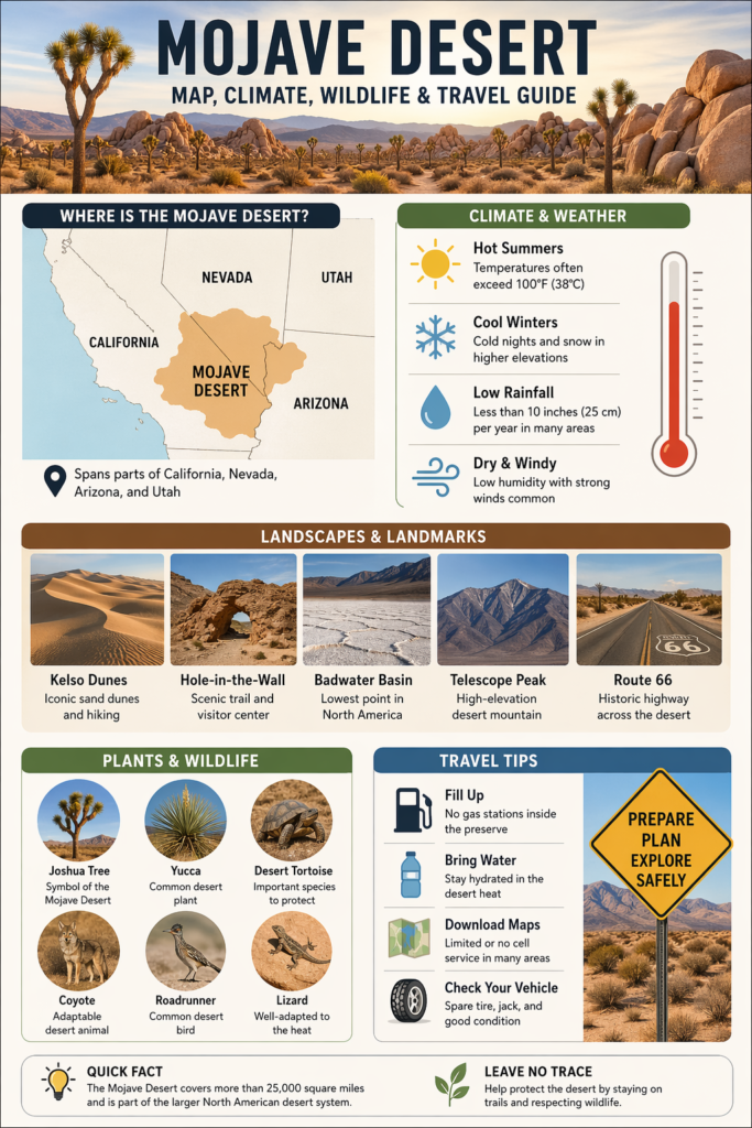
The Mojave Desert is a desert region in the western United States, located mostly in southeastern California but extending into Nevada, Arizona, and Utah as well. It is one of the major desert landscapes of North America, and it is often described as a high desert because much of it sits at a significant elevation. That elevation helps explain the sharp shifts in temperature, rainfall, vegetation, and scenery that define the region.
One of the most useful ways to understand the Mojave is to think of it as a transition zone rather than a perfectly bounded box. It connects to other major desert systems and sits between larger geographic forces. The Sierra Nevada to the west blocks moisture flow. The Great Basin to the north shapes climate and ecology. To the south and southeast, the Sonoran Desert spreads. Because of this setting, the Mojave functions as both a destination and a boundary zone. It is a landscape where several desert identities meet and overlap.
The Mojave’s topography is also a major part of its identity. It is not just a level basin of sand. It includes basin-and-range terrain, mountain belts, broad valleys, rocky ridges, dry washes, salt flats, and major dune fields. These physical forms are not incidental details. They shape how water moves, where plants can survive, how animals travel, and how roads must be built and maintained. In other words, the land itself controls much of the desert’s character.
Another reason the Mojave stands apart is that it is ecologically active, not empty. Springs, seeps, soil variation, and altitude differences create many smaller habitat zones inside the larger desert. Those microhabitats support an impressive range of life. So while some people picture the desert as barren, the Mojave actually functions as a layered living system with a surprising amount of biodiversity.
Mojave Desert Map and Location
A Mojave Desert map is best understood as a map of transition. Its boundaries are real, but they are not rigid in the way state borders are. The desert stretches across southeastern California and reaches into nearby parts of Nevada, Arizona, and Utah. It occupies a broad swath of the interior West, and its edges are shaped by elevation, rainfall, terrain, and ecology rather than just political divisions.
That is why people search both for the Mojave Desert map and the Mojave Desert location. They want to know where the desert begins, where it ends, and how to read it practically. The answer is that the Mojave is mostly in California, but it extends beyond California’s borders. The region is large enough to matter to highway travelers, park visitors, and researchers, yet it is also detailed enough that different sections feel completely different from one another.
A useful mental picture is this: the Mojave lies in a corridor of dry country between mountain systems and adjacent desert zones. The Sierra Nevada helps frame it on the west, the Great Basin shapes it from the north, and the Sonoran Desert presses against it on the south and southeast. This makes the Mojave a desert of edges, contact zones, and gradual shifts. It is not one uniform climate sheet. It is a landscape with gradients.
The map also matters because the Mojave is large enough to include many important travel and natural landmarks. It includes highway corridors, national preserve land, scenic byways, protected habitat, historic crossings, and destinations such as Kelso Dunes, Hole-in-the-Wall, Route 66 segments, and areas associated with Death Valley. People using the map are often doing more than satisfying curiosity. They are planning a road trip, a photography route, a camping trip, or a cross-desert drive, and they need orientation that is both accurate and practical.
Quick Geographic Snapshot
| Topic | Simple Answer | Why It Matters |
| Main location | Southeastern California, plus parts of Nevada, Arizona, and Utah | Helps readers orient themselves quickly |
| Size | More than 25,000 square miles | Shows that the desert is extremely large |
| Larger desert system | North American desert system | Places the Mojave in a broader ecological context |
| Terrain | Mountains, basins, salt flats, dunes | Explains the variety of scenery |
| Core identity | High desert with major elevation change | Clarifies climate and vegetation shifts |
The key idea is simple: the Mojave Desert is not best understood as a single flat zone. It is better understood as a regional system made of connected Landscapes. That is what makes it so important for map readers, travel planners, and nature-focused visitors.
Mojave Desert Boundaries and Regional Identity
The boundaries of the Mojave Desert are sometimes described differently depending on whether the source is using geographic, ecological, or cultural language. That is normal for a region of this size and complexity. In a strict physical sense, the desert is defined by climate, elevation, and vegetation. In a practical sense, it is also identified by major roads, parks, ranges, and landmarks that people recognize as part of the desert experience.
This is why boundary intent is so important. Many readers do not just want to know where the Mojave is. They want to know what belongs to it and what sits just outside it. The answer is that the Mojave is part of a larger desert network, and its boundaries are shaped by natural transitions. In some places, the change is gradual. In others, it becomes more obvious because the land, plants, and weather begin to shift.
The desert’s identity also depends on elevation. Higher areas can feel cooler, greener, and more wind-exposed, while lower basins are hotter and drier. That means the Mojave can contain very different conditions within a relatively short distance. A person traveling through it may cross from Joshua tree country into pinyon-juniper terrain, then into steep mountain areas or broad desert basins. That diversity is part of the desert’s defining character.
The Mojave is also historically connected to movement. Indigenous routes, Spanish exploration paths, the Mojave Road, Route 66, rail travel, and modern highways all cut through or near the region. As a result, the desert boundary is not only a natural line. It is also a route-based space that has been crossed, mapped, and reimagined for centuries.
Mojave Desert Climate and Weather Patterns
The Mojave Desert climate is shaped by dryness, heat, cold nights, strong sun, wind, and major elevation differences. It is a desert climate, but it is not the same everywhere. The weather can change sharply from one part of the region to another, especially as elevation rises or falls.
The most important idea to understand is variability. The Mojave does not behave like one single weather zone. Low valleys can be extremely hot, while higher areas may be much cooler and can even receive snow in winter. Rain is limited overall, but it is not distributed evenly. Mountains often receive more precipitation than lower basins. That means some places support more vegetation and greater habitat diversity than others.
Summer is the most intense season for many visitors. Heat can rise well above comfortable travel levels, and exposed road walking or hiking can become dangerous quickly. But winter brings its own realities. Mornings can be cold, higher elevations can get snow, and wind can add another layer of discomfort. Spring and fall can be the most balanced seasons, but weather still shifts fast, and travelers should never assume stable conditions.
Desert weather is also defined by the difference between day and night temperatures. Sunny afternoons may be scorching, yet nighttime temperatures can drop dramatically. This daily swing is one of the clearest reasons the Mojave is called a high desert. Elevation moderates or intensifies conditions, and the air itself often feels drier and thinner than in more humid regions.
For visitors, the main lesson is straightforward: do not treat the Mojave as one flat temperature field. A route that starts in a low, hot basin may end in a much cooler mountain area. Planning for layers, hydration, sun exposure, wind, and route conditions is essential.
Mojave Desert Landscape Features
The Mojave Desert is famous for landforms that are both dramatic and instructive. The region includes dunes, rocky hills, dry lakebeds, salt flats, lava fields, mountain ranges, canyons, and broad basins. That physical variety is one of the strongest reasons the desert is so memorable. It looks different from place to place because the land itself is constantly changing.
One of the most iconic features is the dune field. Dunes may seem like simple sand hills, but in the Mojave,e they are the result of long-term wind movement, sediment supply, and desert geology. Large dune systems tell a story about ancient water sources, dried lakebeds, and ongoing atmospheric movement. They are living landforms, not static piles of sand.
The mountain-and-basin structure is another key feature. Valleys collect heat and dryness, while mountains may intercept moisture and support different vegetation. That contrast creates a visible ecological layering. Lower desert flats often look sparse and open, but higher slopes may show juniper, pinyon pine, or even white fir in certain locations. This variation is part of what makes the Mojave feel like several different deserts assembled into one region.
Springs and seeps are smaller features, but they are incredibly important. In the desert, even a tiny water source can support plant growth, bird activity, insect life, and mammal movement. These wet spots become ecological anchors in an otherwise dry environment. They are also useful reminders that the Mojave is not lifeless. Its ecology depends on hidden and intermittent water just as much as on open landforms.
Major Landscape Features at a Glance
| Feature | Why It Stands Out | Best Use for Visitors |
| Kelso Dunes | Large and famous dune field | Hiking, photography, and geology |
| Badwater Basin | Lowest point in North America | Landmark viewing, desert contrast |
| Telescope Peak | High-elevation desert mountain landmark | Extreme elevation example |
| Springs and seeps | Support wildlife and plant life | Ecology learning, animal watching |
| Mountain basins | Create microclimates and habitat differences | Map reading, landscape understanding |
One of the most useful ways to think about the Mojave is that the landforms are not decoration. They explain how the desert works. They influence travel, weather, habitat, and history all at the same time.
Mojave Desert Plants and Flora
Plant life in the Mojave Desert is a story of adaptation, elevation, and timing. Desert plants survive by using specialized strategies to conserve moisture, avoid heat stress, and reproduce during favorable windows. The result is a plant community that may look sparse at first glance but is actually highly organized and highly resilient.
The most famous plant in the region is the Joshua tree. For many readers, the Joshua tree is the visual symbol of the Mojave Desert. It defines the look of the landscape in many lower-elevation areas, and it has become closely tied to the region’s identity. But it is only one part of the larger floral system. The Mojave includes yucca, cholla, creosote communities, cacti, shrubs, grasses, and higher-elevation tree species in more elevated zones.
One of the biggest ecological lessons in the Mojave is that elevation changes plant communities. Lower desert floors may support Joshua trees and yucca, while higher elevations can contain juniper, pinyon pine, and white fir. That transition is essential for understanding the region’s ecology. It shows that the desert is not one fixed biological zone, but a vertical and horizontal mosaic.
Many annual plants in the Mojave use a survival strategy based on speed. They grow quickly after seasonal moisture, complete their life cycle, and disappear before extreme drought returns. This strategy allows the desert to burst into color during favorable periods without relying on permanent water. The result can be brief but striking spring growth, especially after enough winter rain.
Plants Readers Often Want to Know About
| Plant | Where It Grows | Why It Matters |
| Joshua tree | Lower desert areas | Signature plant of the Mojave |
| Yucca | Lower elevations | Common and recognizable desert plant |
| Cholla | Lower elevations | Easy-to-spot cactus group |
| Juniper | Higher elevations | Indicates cooler, higher terrain |
| White fir | Higher elevations | Shows that the Mojave includes forested mountain zones |
A strong Mojave Desert plants section should always show this range. The plant community is part of the map story, the weather story, and the travel story. Vegetation helps readers understand where they are and what kind of environment they are moving through.
Mojave Desert Wildlife
The Mojave Desert wildlife story is far richer than many people expect. Desert ecosystems can appear quiet at first, but the Mojave contains a broad range of species adapted to heat, dryness, scarce water, and wide-open terrain. Mammals, birds, reptiles, amphibians, fish, insects, and arachnids all play a role in the ecological network.
Bird diversity is especially notable because the region includes open desert, rocky slopes, water-linked habitats, and elevation gradients. That range of habitats makes the Mojave valuable for birdwatching, especially around springs, seeps, dawn hours, and cooler evening periods. Reptiles are also abundant, and many species depend on temperature and cover to survive the harshness of the desert day.
The desert tortoise is one of the region’s most recognized species. It is closely associated with Mojave conservation, habitat protection, and road safety. Drivers in desert areas need to be alert because tortoises may cross roads, especially during certain seasons and after rain. That makes wildlife awareness a real travel issue, not just an ecological detail.
The broader wildlife picture also reminds readers that desert abundance is often hidden. Small insects, arachnids, rodents, and other animals form the base of a food web that supports larger species. Water sources, vegetation patches, and rocky shelter all matter. The desert is not empty. It is carefully balanced.
Wildlife Groups and What They Mean
| Wildlife Group | General Ecological Meaning | Visitor Takeaway |
| Mammals | The desert supports many land animals | The ecosystem is more populated than it appears |
| Birds | Strong diversity across habitat types | Good for birding and quiet observation |
| Reptiles | Heat-adapted species are common | Watch roads and warm surfaces |
| Amphibians | Linked to scarce water sources | Water features are ecologically important |
| Fish | Found only where water persists | Springs and rare water bodies matter |
| Insects and arachnids | Essential to desert food webs | Small life supports the entire system |
Wildlife watching in the Mojave is best done with patience. Early morning and late evening are often the most productive times. Quiet behavior, slow movement, and respect for distance make the experience better for both the observer and the animals.
Human History in the Mojave Desert
The Mojave Desert has a deep human history that stretches back thousands of years. It has been used, crossed, mapped, defended, inhabited, and remembered by Indigenous communities, explorers, traders, settlers, miners, railroad workers, and modern travelers. This long timeline is one of the reasons the desert feels historically important as well as geographically striking.
A key part of this history is movement. The desert was never simply a barrier. It was also a passageway. Long before modern highways, Indigenous travel routes crossed the region and connected communities. Later, Spanish explorers and missionaries followed and adapted some of those routes. In the nineteenth century, the Mojave Road became one of the best-known overland crossings through the area.
The Mojave Road is especially important because it shows how travel history and Indigenous history overlap. It is not just a road in the modern sense. It is a historic corridor built on older movement networks and later adapted for military and overland use. That layered history gives the route cultural depth and makes it more than a scenic drive.
Route 66 also belongs in the Mojave story. The highway turned the desert into a symbol of American road culture, migration, travel, and endurance. Sections between Needles and Barstow are especially well-known because of their heat, openness, and association with classic cross-country driving. That makes the Mojave a place where old travel systems and modern road culture meet.
The preserve and surrounding desert lands also reflect a long connection between people and the environment. Mining, rail development, ranching, tourism, and conservation all shaped the region. Today, the historical story continues through preservation, interpretation, archaeology, and protected landscapes.
Historical Highlights
| Historic Feature | Why It Matters | Search Intent It Satisfies |
| Mojave Road | Historic overland route with deep cultural roots | History, trail, map |
| Old Spanish Trail | Part of the regional travel heritage | Heritage, archaeology |
| Route 66 | A famous highway crossing the desert | Road trip, nostalgia |
| Preserve history | Long human connection to the land | Culture, education |
A good Mojave Desert history section should connect land and people rather than treating them separately. The desert shaped human movement, and human movement shaped how the desert was experienced and recorded.
Roads, Access, and the Mojave Desert Travel Guide
Traveling through the Mojave Desert is rewarding, but it requires planning. This is not a place where casual navigation is enough. Heat, distance, limited services, rough roads, and weak cell coverage all create conditions that can quickly turn a simple outing into a serious problem if a traveler is unprepared.
One of the most important travel realities is service scarcity. Inside protected desert areas, gas stations may be nonexistent, charging stations may be unavailable, and cell service may be minimal or absent. That means visitors need to arrive prepared, not assume they can solve problems later. Fuel, water, navigation, and road-condition awareness are basic needs.
GPS apps can also be misleading in remote desert terrain. Some map applications may route drivers onto roads that are not safe for passenger vehicles. This is a major issue in the Mojave because road type matters. A road that looks straightforward on a screen may actually require high clearance, four-wheel drive, or better local knowledge. Official maps and current road-condition information are more reliable than guesswork.
Several road corridors are especially important in the Mojave. Kelbaker Road, Cima Road, Essex Road, and access routes near Interstate 15 and Interstate 40 help visitors reach dunes, historic sites, trailheads, visitor centers, and scenic viewpoints. These roads make the desert legible. They also help travelers understand how destinations connect across a large region.
Travel Safety Checklist
| Safety Item | Why It Matters |
| Full fuel or full charge | There may be no gas or charging inside the preserve |
| Water | Heat and distance can become dangerous quickly |
| Spare tire and jack | Road debris and rough surfaces are common |
| Offline map | Apps may fail or route incorrectly |
| Food and light source | Delays can stretch longer than expected |
| Proper clothing | Desert weather changes fast across elevations |
The main point is simple: the Mojave rewards preparation and punishes assumptions. A traveler who understands the road network, weather risks, and service limitations will have a far better and safer experience.
Best Things to Do in the Mojave Desert
A strong travel guide should not only warn readers. It should also give them a clear, practical set of things to do. The Mojave Desert offers scenic drives, short hikes, historic stops, wildlife viewing, and dramatic natural landmarks. The challenge is choosing activities that fit your time, fitness level, and season.
One of the most famous experiences is hiking the Kelso Dunes. The dune field is visually powerful, physically engaging, and unique enough to be memorable long after the visit ends. The landscape feels open and immense, and the shifting sand gives the site a sense of motion. At the same time, it is important to respect seasonal heat and trail conditions, because the dune area can become dangerous in high temperatures.
Hole-in-the-Wall is another excellent stop, especially for families, beginners, or travelers who want a shorter walk. It offers an easier way to experience desert geology and nature interpretation without committing to a long or strenuous outing. It is also useful as a stop for learning and orientation.
Scenic driving is one of the best ways to experience the Mojave if your goal is broad landscape understanding. Roads like Kelbaker and Cima connect dunes, lava formations, viewpoints, and historical sites. A road trip through the desert is not just transportation. It becomes a moving lesson in landscape diversity.
Birdwatching and wildlife observation are especially rewarding during cooler hours. Springs, seeps, and shaded zones often create the best conditions for spotting activity. Sunrise and sunset are often the most comfortable and productive times for observation, photography, and quiet walking.
Top Activities
| Activity | Why It Stands Out | Practical Note |
| Hike Kelso Dunes | Huge dune field with dramatic scenery | Avoid summer heat |
| Walk Hole-in-the-Wall Nature Trail | Easy and accessible | Good for families and short visits |
| Drive scenic roads | Connects landmarks and landscapes | Check road conditions first |
| Visit historic sites | Adds cultural depth | Great for history lovers |
| Watch birds and wildlife | Strong species diversity | Best at dawn and dusk |
A good Mojave visit is usually a combination of movement and observation. Drive a scenic corridor, stop at a landmark, walk a short trail, and leave enough time to notice the details that make the region special.
Mojave Desert Landmarks to Include in Your Trip
Some landmarks are especially useful because they help readers build a mental map of the region. The best Mojave landmarks are memorable, practical, and geographically meaningful. They help visitors understand where they are, what they are seeing, and how the desert fits together.
Kelso Dunes is one of the most iconic examples. It is not just beautiful. It is also a great reference point for understanding dune formation, wind patterns, and desert scale. Hole-in-the-Wall is another strong landmark because it combines a visitor center, trail access, and interpretive value. Kelso Depot adds historical texture by linking the desert to rail and freight history.
Death Valley is another major landmark in the wider Mojave context because it shows elevation extremes in a way few other places can. A region that includes both very high peaks and deeply low basins is ideal for teaching readers that deserts are complex systems, not monotone plains.
Landmark Guide
| Landmark | Best Known For | Visitor Value |
| Kelso Dunes | Sand field and hiking | Iconic scenery |
| Hole-in-the-Wall | Trail access and visitor center | Easy stop and education |
| Kelso Depot | Historic rail and road atmosphere | History and rest stop |
| Death Valley | Elevation extremes | Strong desert contrast |
| Mojave Road | Historic crossing route | Cultural and navigational value |
Landmarks matter because they turn abstract geography into a lived experience. They are the points that make the map memorable.
Environmental Issues and Conservation
The Mojave Desert is beautiful, but it is also fragile. Desert ecosystems can appear tough because they survive heat and drought, but that resilience does not mean they are immune to damage. In fact, desert environments are often highly sensitive to disruption.
Climate change is one major pressure. Rising temperatures and altered precipitation patterns can affect water availability, plant survival, wildfire risk, and habitat stability. In a place where water is already scarce, even small shifts can have large consequences. Hotter conditions can also strain wildlife, increase stress on vegetation, and make recovery from disturbance more difficult.
Fire is another major issue. When fire affects desert vegetation, especially slow-growing plant communities, the recovery process can be long and uncertain. Joshua tree habitat is particularly important because it is closely tied to the region’s identity and ecology. Once damaged, these systems may take years or decades to recover, if they recover at all.
Invasive species and habitat fragmentation add more pressure. Roads, development, and altered land use can interrupt animal movement and plant recovery. Springs and seeps are also vulnerable because they support a disproportionate amount of biodiversity. Protecting them is essential for the long-term health of the desert.
Conservation in the Mojave is therefore about more than one species or one scenic area. It includes soil, water, vegetation, wildlife, historic sites, and the integrity of large connected landscapes. The desert is not just a place to admire. It is a place that requires stewardship.
Useful Facts About the Mojave Desert
A few compact facts can make the topic easier to remember and easier to use in search and writing.
The Mojave Desert covers more than 25,000 square miles and spans parts of California, Nevada, Arizona, and Utah. It is named for the Mojave people and belongs to the larger North American desert system. It is a high desert, meaning much of it sits at elevation rather than only at low desert levels.
In the Mojave region, the weather can be severe and variable. Summers can be extremely hot, winters can be cold at higher elevations, and precipitation remains limited overall. This makes the region both beautiful and potentially hazardous for unprepared travelers.
Kelso Dunes are among the desert’s best-known landforms. They are large, dramatic, and shaped by long-term wind movement. Their scale makes them one of the strongest visual symbols of the region.
The desert also holds remarkable biodiversity. Mammals, birds, reptiles, amphibians, fish, insects, and arachnids all contribute to the ecological fabric. Even though the region is dry, it is biologically active.
Finally, the Mojave has major cultural significance because of historic routes like the Mojave Road and Route 66. These roads turned the desert into a place of travel history, regional identity, and national memory.
FAQs
Britannica says the Mojave Desert covers more than 25,000 square miles. It is a large region with changing boundaries depending on whether the source is using geographic or ecological framing.
It spans parts of California, Nevada, Arizona, and Utah. Most of it lies in California, but the desert reaches across state lines.
Because much of it sits at elevation rather than only at low, flat desert levels. The region includes broad elevation changes, and those changes affect both temperature and rainfall.
Bring water, fuel, and a spare tire. Save the official road conditions page, because there is minimal to no cell service and no gas or charging stations inside the preserve. Do not rely only on third-party map apps.
The Joshua tree is the most recognizable plant of the Mojave and a major symbol of its landscape. It is strongly associated with lower-elevation desert communities.
Conclusion
The Mojave Desert is more than a dry region on the map. It is a diverse desert landscape shaped by elevation, weather, wildlife, and history. Whether you are planning a trip or learning about the region, understanding the Mojave helps you appreciate its beauty and travel safely.