Introduction
A map of the California Mojave Desert helps readers understand where the desert begins, which parks and roads matter most, and how the landscape changes across this vast region. Because the Mojave has irregular boundaries and Important transition zones, a clear map is useful for travelers, students, and anyone studying the desert.
Overview of the California Mojave Desert
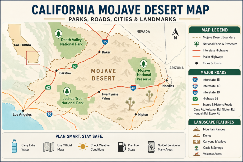
The Mojave Desert is an arid region found mainly in southeastern California, with portions extending into Nevada, Arizona, and Utah. It is one of the major desert systems of the American Southwest. In California, it is especially significant because it includes famous and heavily visited places such as Joshua Tree National Park, Death Valley National Park, and Mojave National Preserve.
What makes the California side so interesting is that it is not simply empty wilderness. It is a living landscape made up of mountain ranges, protected public lands, historic travel corridors, wildlife pathways, dunes, canyons, and transition areas. In some places, the Mojave blends into the Colorado Desert. In others, it rises into higher elevations where the climate is cooler, and the plant life changes noticeably.
A map of the California Mojave Desert should therefore show more than lines and labels. It should explain how the region functions. It should show where roads lead, where ecosystems overlap, where visitors are likely to travel, and where official mapping tools can help people stay safe and informed.
What Makes the California Mojave Desert Unique?
The California Mojave Desert stands apart from many other desert regions for several important reasons.
First, it is a land of extremes. Summer temperatures can become intense, winter nights can turn surprisingly cold, strong winds are common, and some high-elevation areas can even receive snow. A person looking at a desert map might assume all desert terrain is the same, but the Mojave proves that idea wrong. It is varied, layered, and often dramatic.
Second, it is a region of transition. Around Joshua Tree and nearby areas, the Mojave meets the Colorado Desert. That overlap creates a mixed ecological zone where plant communities, wildlife habitats, and weather patterns blend. This transition makes the region especially interesting for natural history and geography.
Third, it contains major public lands. Large parts of the California Mojave are managed by the National Park Service and the Bureau of Land Management. That means official maps are not just helpful; they are essential. Road conditions, closures, trail access, and visitor rules can all change, sometimes with little warning.
Fourth, the area has a deep human history. Indigenous pathways, trade routes, rock art, mining settlements, homesteads, and early road systems all shaped the region long before modern highways arrived. A good map should reflect both the natural and cultural story of the desert.
Where Is the California Mojave Desert Located?
The California Mojave Desert lies mostly in southeastern California. It stretches across large desert zones east of the Los Angeles area and north of the Colorado Desert.
When you view it on a broader map, the Mojave sits between mountain systems and desert basins. Its edges are not always sharp, but several geographic anchors help define it:
The Tehachapi Mountains to the northwest
The San Gabriel Mountains and San Bernardino Mountains to the south
Large desert basins and high desert plateaus across eastern California
Road corridors that link towns, parks, and public lands
The simplest way to think about it is this: the Mojave is not one flat desert plain. It is a broad, diverse region made up of valleys, uplands, transition zones, and famous park units that sit inside it.
Main Boundaries on a Map of California Mojave Desert
A strong map of the California Mojave Desert should straightforwardly explain the boundaries, without making the region seem more rigid than it really is.
Northern and Northwestern Edge
The northern and northwestern part of the Mojave begins to shift toward other dry lands and higher terrain. The transition is not always marked by a single line. Instead, changing elevation, different Vegetation, and altered landforms signal the move from one ecological zone to another.
Southern Edge
This is where one of the most interesting transitions appears. In places such as Joshua Tree National Park, the Mojave meets the Colorado Desert. That overlap is one of the main reasons Joshua Tree is so important for understanding the desert landscape. It is a clear example of two systems blending.
Eastern Edge
The desert extends toward Nevada and Arizona. California is only one portion of the larger Mojave system, but the California side is the most searched, most visited, and most commonly featured in travel guides.
Western Edge
To the west, the terrain becomes more mountainous and gradually blends into other California regions. This edge is more about a gradual transition than a precise cutoff. That is why a useful map should not only draw borders; it should also explain overlap areas, park zones, and major access points.
Because the boundaries are ecological as well as geographic, the best maps show both the land and the relationships between different desert environments.
Major Parks That Should Appear on the Map
Any helpful map of the California Mojave Desert should include the most significant parks, preserves, and public lands.
1. Joshua Tree National Park
Joshua Tree is one of the best places to understand the Mojave because it sits where two desert systems meet. The park includes both Mojave and Colorado Desert landscapes, so it displays the transition effect very clearly. It is one of the most recognizable and useful reference points on a desert map.
2. Death Valley National Park
Death Valley is famous for being the hottest, driest, and lowest national park in the United States. It is a central location on any California Mojave map because it reveals the desert at its most extreme. Its scale, road network, and dramatic landforms make it an essential anchor point.
3. Mojave National Preserve
This preserve covers a huge section of the eastern California desert. It includes dunes, lava fields, Joshua tree woodland, canyons, and major travel routes. It is one of the most useful places for understanding the broader structure of the California Mojave.
4. BLM Public Lands
A large amount of the California Mojave is public land managed by the Bureau of Land Management. These lands matter because many travelers cross them by highway, back road, or off-highway route. Since access rules and conditions can shift, official BLM maps are especially valuable.
These places are not just names on a page. They are the backbone of the California Mojave story.
Map Table: What Each Official Map Source Is Best For
| Map Source | Best Use | Strength | Limitation |
| Joshua Tree National Park maps | Park boundaries and visitor planning | Shows the park clearly and explains the Mojave/Colorado overlap | Not a full regional desert map |
| Death Valley maps | Long-distance desert travel | Useful for road status, hiking, and backcountry access | Focused on one park only |
| Mojave National Preserve maps | Preserve travel and route planning | Helpful for roads, landmarks, and downloadable brochure maps | Not a full California desert overview |
| BLM California maps | Public land navigation | Useful for georeferenced PDFs and broad land coverage | More technical than tourist-friendly maps |
| Regional tourism pages | General context | Good for broad orientation | Not ideal for navigation |
This table helps readers quickly identify which map source is best for each task.
Important Roads on the California Mojave Desert Map
Roads are a major part of the desert experience. In the Mojave, roads are not just lines of transportation. They are lifelines that connect towns, parks, services, and remote destinations.
Major Roads and Corridors
Some of the most important routes to include on the map are:
Interstate 15
Interstate 40
Interstate 10
Highway 62
Cima Road
Kelbaker Road
Nipton Road
Ivanpah Road
Essex Road
These roads connect visitor centers, park entrances, desert towns, scenic areas, and isolated public lands.
Why Roads Matter in the Mojave
Unlike dense city maps, desert roads may be long, isolated, and affected by weather, washouts, or surface damage. Some routes are paved, while others may be rough, sandy, or closed during certain seasons or events.
A reliable map should help readers understand:
where the main roads are
Which roads lead to parks
Which roads are practical for visitors
Which roads may require caution or official updates
Travel Example
If someone is traveling to Mojave National Preserve, they may approach from Interstate 15 or Interstate 40, depending on their starting point. If someone is going to Joshua Tree, they may use Interstate 10 or Highway 62. These details matter because the route shapes the whole trip, especially in a vast desert landscape.
Landscape Features to Show on the Map
A strong map should show more than roads and park names. It should also identify the major landscape features that make the Mojave visually and ecologically distinct.
Key Landscape Features Include
Dunes
Canyons
Mountain ranges
Valleys
Volcanic terrain
Rocky hills
Dry washes
Oases
Salt flats
Desert basins
Why Landscape Features Matter
The Mojave is not a flat, endless sheet of sand. It contains hills, basins, ridges, and elevation changes that affect climate, vegetation, and travel conditions. A driver can move from a low, hot basin into a cooler mountain setting in a relatively short distance.
This is why a detailed map is helpful. It shows not only where the desert is, but also how the land is shaped and why conditions vary from place to place.
Examples of Well-Known Landscape Areas
Kelso Dunes
Cinder cone zones
Lava tube regions
Badlands
Joshua tree woodlands
Rock formations and boulder fields
Springs and riparian areas
Each of these contributes to the identity of the California Mojave Desert.
Climate and Weather on the California Mojave Desert Map
The California Mojave Desert is not only hot. It is dry, windy, and highly variable. Weather conditions can shift quickly, especially when elevation changes over a short distance.
What the Weather Is Like
Summer temperatures can become extreme.
Winter nights can be cold.
Higher elevations may receive snow.
Strong winds are common.
Flash floods can follow heavy rain.
Conditions can change quickly across short distances.
Why Climate Matters for Maps
Climate affects almost every aspect of desert travel and planning:
road safety
hiking conditions
wildlife behavior
camping comfort
photography
access to remote destinations
An article about the Mojave should treat weather as a central planning factor, not a side note. In this region, climate is one of the most important things a map can help people understand.
Simple Example
Two locations may look close together on the map, but one may sit in a hotter low basin while the other is higher and cooler. That is why elevation must be part of any serious desert map discussion.
Plant Life in the California Mojave Desert
One reason people enjoy this region so much is the plant life. The Mojave is not barren. It is full of species adapted to heat, dryness, bright sunlight, and limited water.
Common Plants in the Mojave
Joshua trees
Creosote bush
Desert lavender
Cacti
Yucca
Pinyon pine
Juniper
Palm species in oasis areas
Mosses and lichens in certain places
Shrubs and wildflowers
Why Plant Zones Matter on a Map
Plants reveal the character of a place. A map that shows habitat zones is far more useful than one that only displays park outlines. Vegetation tells readers what type of desert they are looking at and how the environment changes across the region.
Main Vegetation Communities
Desert floor scrub
Joshua tree woodland
Riparian zones
Dune habitat
Pinyon-juniper woodland
Mixed transition zones
Simple Reading Tip
If Joshua trees appear on the map, you are likely looking at one of the most recognizable Mojave habitats. But the desert includes much more than that one plant. It contains many different vegetation communities that reflect elevation, water availability, and soil type.
Animal Life in the California Mojave Desert
Wildlife is another reason this map deserves detail. A desert map becomes more useful when it also helps readers understand animal habitats and movement corridors.
Common Animals Include
Desert tortoises
Coyotes
Foxes
Bobcats
Bighorn sheep
Kangaroo rats
Owls
Bats
Lizards
Snakes
Many bird species
Why Wildlife and Maps Are Connected
Animals depend on habitat, water, shelter, and safe travel corridors. A map that shows springs, washes, mountains, and protected zones helps explain where wildlife may live and move.
Important Wildlife Facts
Many desert animals are active at night or early morning.
Birds migrate through the region seasonally.
Springs and riparian zones are especially important.
Some species are threatened or sensitive to habitat loss.
Why This Matters to Readers
Travelers often want to know where wildlife may appear, but they also need to know how to act responsibly around animals and fragile habitats. A good map and a good explanation help with both.
Human History and Culture on the Mojave Map
The California Mojave Desert is not only a natural landscape. It is also a place with a long and meaningful human history.
Who Lived Here First?
Indigenous peoples lived in the Mojave for thousands of years. Their trails, trade networks, and regional knowledge shaped the land long before modern roads were built.
Historic Layers in the Desert
Rock art sites
Trade routes
Mining districts
Homesteads
Old roads
Historic cabins
Rail and transportation routes
Why Cultural History Belongs in a Map Article
A map is not only about geography. It is also about meaning, memory, and use. People search for the map of California’s Mojave Desert because they want to know where places are and why they matter. A strong pillar article should respect that history and show how the region has supported human life over time.
Travel and Safety Tips for the California Mojave Desert
The Mojave is beautiful, but it demands preparation and respect. Anyone using a desert map should also understand the basics of safe travel.
Important Travel Tips
Carry extra water.
Check road status before leaving.
Do not depend only on cell service.
Use official maps for backcountry travel.
Start hikes early.
Watch weather changes carefully.
Prepare for long distances between services.
Tell someone your route.
Why Desert Travel Is Different
In cities, help is usually nearby. In the Mojave, it may be far away. Some roads are remote, and some locations have little or no service at all. That makes planning essential.
Common Risks
Overheating
Dehydration
Getting lost
Sand damage or rough-road damage
Flash floods
Snow or ice at higher elevations
Vehicle trouble in isolated zones
Best Practice
Treat desert travel like a serious trip, even when the destination seems straightforward on the map. In the Mojave, the landscape is bigger, harsher, and more isolated than it first appears.
Official Map Resources You Can Trust
The safest maps are official maps. That is especially true in a large, remote, and changeable desert region.
Top Official Sources
National Park Service
The National Park Service offers maps for Joshua Tree, Death Valley, and Mojave National Preserve. These maps are useful for route planning, park boundaries, hiking areas, scenic drives, and visitor centers.
Bureau of Land Management
BLM California provides map viewers, brochures, georeferenced PDFs, and other land management tools. These are useful for public lands and broader regional planning.
Visitor Centers and Park Brochures
Visitor centers often provide the most current local maps and safety guidance. That makes them extremely useful for trip planning and last-minute updates.
Why Official Maps Matter
Official maps are more likely to show:
current closures
park boundaries
trailheads
camping rules
road conditions
protected areas
Simple Rule
Use official maps first. Use other sources for background context only.
Table: Best Places to Include in a California Mojave Desert Map Article
| Place | Why It Matters | Best Feature |
| Joshua Tree National Park | Shows the Mojave/Colorado transition | Ecological overlap |
| Death Valley National Park | Shows extreme desert conditions | Heat, elevation, and landforms |
| Mojave National Preserve | Covers a wide and varied desert area | Roads and habitat diversity |
| BLM lands | Expands the public land system | Regional access |
| Twentynine Palms | Major gateway town | Visitor access |
| Baker | Important travel point | Road entry |
| Nipton | Small desert stop | Route planning |
| Cima | Historic corridor area | Preserve access |
This table makes it easier for readers to understand which places belong on the map and why they matter.
Why Joshua Tree Is So Important in the Mojave Story
Joshua Tree deserves special attention because it is one of the clearest examples of desert transition in California.
What Makes Joshua Tree Special
It is located where two desert ecosystems meet, creating a unique transition zone. The area supports a mix of plant communities from both regions. It attracts a large number of visitors due to its natural beauty and accessibility. It also demonstrates that Mojave Desert boundaries are gradual rather than sharply defined.
Why It Matters on a Map
If you want to understand the Mojave, Joshua Tree is one of the best places to start. It acts like a living example of why desert maps should show overlap zones instead of only drawing clean lines.
Simple Example
A visitor may think they are in one desert, but the land may actually be part of a transition area. That is why strong maps and clear explanations are so important.
Why Death Valley Is Essential on a California Mojave Desert Map
Death Valley gives the map its extreme side. It shows the desert at one of its most dramatic and powerful limits.
Why It Matters
The area shows the harshest desert conditions found in the region. It contains unforgettable landforms that define the desert landscape. The location is a major destination for road trippers and photographers exploring the area. It also helps explain the full range of Mojave landscapes in one place.
What to Show on the Map
Main roads
Visitor centers
Scenic drives
Backcountry access
Major viewpoints
Hiking areas
Travel Importance
Many people visit Death Valley without realizing how large and remote it is. A good map helps visitors plan more effectively and stay safer while exploring.
Why Mojave National Preserve Should Be on the Map
Mojave National Preserve is one of the most useful places for understanding the California Mojave Desert as a whole.
Why It Stands Out
This large protected area covers a significant part of the desert. The region includes diverse habitats that support a wide range of plant and animal life. Major road corridors connect key locations across the landscape. The terrain features dunes, lava fields, woodlands, and canyons, adding to its geographic variety. Nearby historic routes and desert towns also make the area important for both travel and history.
Useful Map Labels
Kelso Depot
Kelso Dunes
Cima Road
Lava tube area
Major preserve entrances
Nearby towns and stop points.
Why Readers Need It
It helps people understand the desert not as empty land, but as a region with movement, history, ecological variety, and travel pathways.
Pros and Cons
Pros
This helps readers understand real desert boundaries while showing how the region is organized. Park planning becomes easier with clearly identified key locations and access routes. Safety improves through the highlighting of important roads, entry points, and travel corridors. The content also draws attention to wildlife, history, and habitat zones across the desert. Overall, it provides a more complete and useful picture than a simple outline map.
Cons
The region is complex and cannot be perfectly captured on one simple map.
Third-party maps may not reflect current road conditions.
Some maps focus only on one park and ignore the larger region.
The desert changes with season, elevation, and weather.
This is why the strongest article should combine map details with practical travel advice.
Interesting Facts About the California Mojave Desert
Here are some quick facts that readers often find memorable:
Death Valley is the hottest, driest, and lowest national park in the United States.
Joshua Tree sits in a transition zone where the Mojave and Colorado deserts meet.
Mojave National Preserve covers a huge area with very different habitats.
The California Mojave includes both low desert and higher-elevation zones.
Official maps matter because road conditions can change quickly.
Desert wildlife is often active at dawn, dusk, or night.
These facts help make the article more engaging and easier to remember.
Environmental Issues and Conservation
The California Mojave Desert may look tough, but it is also fragile. Its beauty can hide how vulnerable the ecosystem really is.
Main Environmental Concerns
Habitat loss
Climate stress
Fire damage
Invasive species
Threatened wildlife
Pressure from development and recreation
Why Conservation Matters
A desert ecosystem can take a long time to recover after damage. Roads, off-trail travel, careless use, and wildfire can create long-lasting impacts.
What Good Maps Can Do
A good map helps protect the region by:
guiding visitors along proper routes
reducing accidental damage
showing protected zones
helping people understand habitat boundaries
Simple Message
The desert is not empty. It is alive, and it needs careful treatment.
How to Use a Map of California Mojave Desert for Travel
A map is most useful when it is used thoughtfully and with planning.
Before You Go
Read the map before the trip.
Check the weather and road conditions.
Choose the correct park or preserve.
Mark fuel and water stops in advance.
While You Travel
Stay on your planned routes.
Watch road signs and closure notices.
Do not assume a dirt road is easy.
Keep a backup map available.
After You Arrive
Use visitor centers for updated information.
Check trail conditions before setting out.
Stay aware of sun exposure, heat, and distance.
This approach turns the map into a real travel tool instead of just a visual reference.
FAQs
Yes. The Mojave Desert is located mainly in southeastern California, but it also extends into Nevada, Arizona, and Utah.
The best official sources are the National Park Service and the Bureau of Land Management. They provide maps for parks, preserves, roads, and public lands.
At minimum, the map should include Joshua Tree National Park, Death Valley National Park, and Mojave National Preserve.
Joshua Tree is important because it sits where the Mojave and Colorado deserts meet. It shows the transition nature of the region very clearly.
Not fully. GPS can help, but official maps are safer because road status and desert conditions can change.
Important routes include Interstate 10, Interstate 15, Interstate 40, Highway 62, Cima Road, Kelbaker Road, Nipton Road, Ivanpah Road, and Essex Road.
Conclusion
The California Mojave Desert is more than a dry landscape on a map. It is a region of parks, highways, wildlife, and changing terrain, and the best maps help readers explore it safely and understand it more clearly.