Introduction
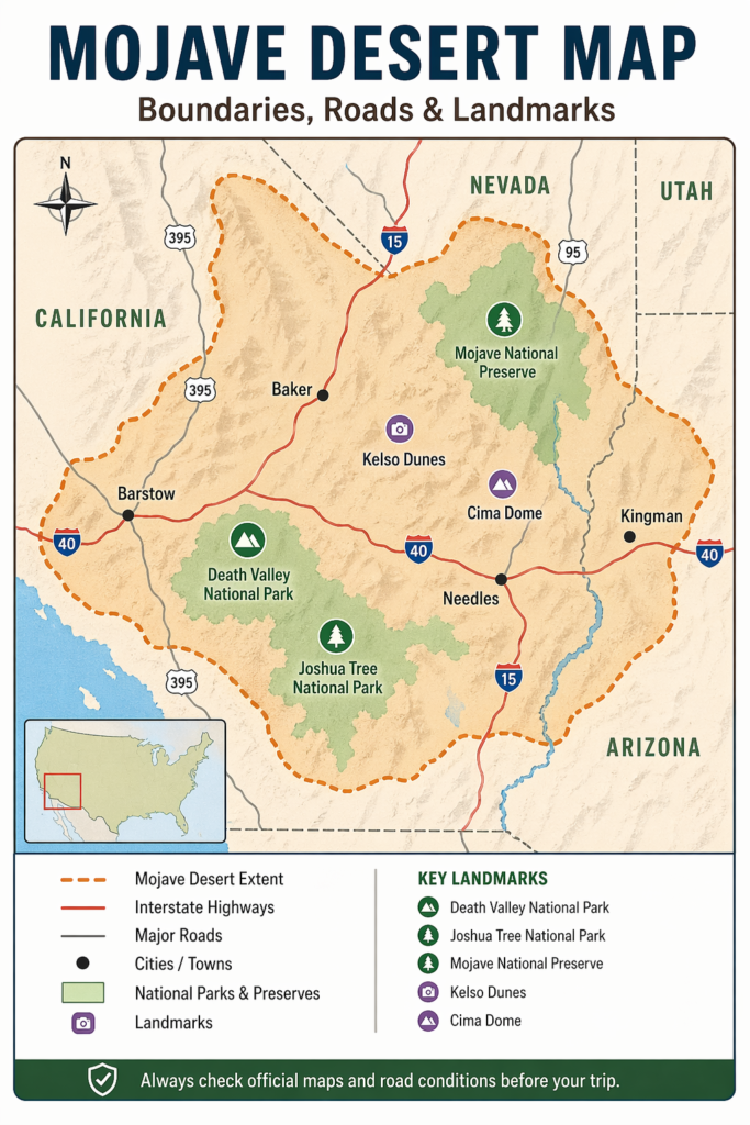
A Mojave Desert map helps you understand where the desert is, which roads cross it, and which landmarks matter most. Because the Mojave spans a large and varied landscape across the Southwest, a clear map is useful for travelers, students, and researchers alike. This guide highlights the desert’s boundaries, major routes, protected areas, and official map sources.
What Is the Mojave Desert?
The Mojave Desert is one of the most recognizable desert regions in North America. It is often described as a high, arid, rugged desert system with a landscape that shifts from place to place. In plain language, it is a transition desert, which means it does not present the same visual pattern everywhere. In one zone, you may see Joshua trees and rocky ridges. In another, you may find salt flats, dune fields, lava formations, or broad open basins.
This geographic diversity makes the Mojave especially important in map reading. A Mojave Desert map is not just about space. It is about spatial relationships, elevation change, climate variation, public land use, and route connectivity. The desert also links together several major ecological and geographic systems, including the Great Basin Desert and the Sonoran Desert, while hosting iconic parks such as Death Valley National Park, Joshua Tree National Park, and Mojave National Preserve.
A well-designed Mojave Desert map helps the reader understand the whole landscape story. It shows terrain, transportation, conservation boundaries, and major destination points in one visual framework.
Where Is the Mojave Desert Located?
The Mojave Desert is located mostly in southeastern California and southern Nevada. Smaller portions reach into Arizona and Utah. On a broad western United States map, the Mojave sits in the interior Southwest, east of the Sierra Nevada and north of the Sonoran Desert.
This placement is not random. The desert’s position shapes its environmental character. The Mojave lies in a rain-shadow zone, meaning mountain ranges block moisture before it can arrive. That contributes to its dry conditions. But dryness does not mean flatness. The region includes valleys, mountain chains, dry lake beds, volcanic fields, rocky slopes, dunes, and salt pans.
When people search for a Mojave Desert map, they usually want one of a few key answers:
Where exactly is the desert located?
What states does it cover?
Which highways cross it?
Which parks fall inside it?
Where can I find an official map for travel planning?
This article answers those questions clearly and systematically.
Why Mojave Desert Boundaries Look Different on Different Maps
One of the most confusing features of the Mojave Desert map is that the boundaries are not always drawn the same way. That is because different mapmakers use different reference frames and different purposes.
Some maps define the Mojave ecologically. These maps emphasize climate, vegetation, elevation, and desert systems.
Some maps show park boundaries. These focus on places like Death Valley or Joshua Tree.
Some maps highlight public lands. These show areas managed by agencies such as the National Park Service or the Bureau of Land Management.
Some maps are built for route planning. These emphasize road access, trailheads, and travel corridors.
So one source may show the Mojave as a large ecological region, while another may show only a preserve, park, or route network. Both can be correct, but they are answering different questions.
A smart map reader should always ask:
Is this map for ecology, tourism, hiking, driving, or land management?
That one question often resolves most confusion.
Mojave Desert Map Overview: The Big Picture
A broad Mojave Desert map reveals a large interior desert system across the western Southwest. The region is famous for:
Dry basins and mountain ranges
Salt flats and dry lake beds
Dunes
Volcanic formations
High desert plateaus
Joshua trees and other iconic desert plants
Wildlife adapted to heat and drought
Protected parks and preserves
Long desert highways and remote access roads
The Mojave is not a smooth, featureless plain. It is a layered terrain made of multiple elevations, landforms, and habitat types. That is precisely why detailed cartography matters. A simple outline map can show location, but a richer map shows the relationships that make the region understandable.
Think of the Mojave as a multi-layer system. The first layer is geography. The second layer is climate. The third layer is roads and access. The fourth layer is flora and fauna. The fifth layer is human history. The sixth layer is protection and conservation. When all six layers are visible, the map becomes much more useful.
Mojave Desert Geography and Landscape
The Mojave Desert is well known for its shifting landscapes. Some areas are steep and rocky. Some are flat and open. Some are sandy. Some contain salt crusts or dry mud flats. Some rise into cooler uplands with forests or transitional vegetation.
This geographic variability is one reason the Mojave Desert map is so visually and intellectually rich. It does not represent one type of desert; it represents many desert expressions in one region.
Main landscape features you may see on a Mojave Desert map
Mountain ranges
Basin-and-range valleys
Dry lake beds
Salt flats
Dunes
Lava flows
Canyons
Rocky hills
High desert plateaus
Springs and desert washes
These landscape features are not merely scenic. They influence travel logistics, wildlife distribution, plant communities, and water availability. They also explain why one part of the Mojave may feel like a classic arid scrub zone while another resembles a rugged mountain landscape.
Low elevations can be intensely hot and dry. Higher elevations may be cooler, windier, and more biologically diverse. A map that captures those contrasts gives the reader a far better understanding of the desert than a flat, generalized outline ever could.
Climate and Weather on the Mojave Desert Map
The Mojave Desert is famous for dryness, but it is not only defined by heat. Climate conditions vary with location, elevation, and season. Some places are hotter. Some are colder in winter. Some are more exposed to the wind. Some receive slightly more or less precipitation. Higher areas can even experience snow.
The key idea is simple: the Mojave is a desert because it is dry, not because it is permanently hot.
What the climate means for map readers
If you are reading a Mojave Desert map, climate is relevant for several practical reasons:
Roads can be damaged by storms or flash flooding.
Backcountry tracks may become dangerous after rain.
Hiking distances may feel more exhausting than expected.
Summer temperatures can become extreme.
Higher elevations may be cold during winter.
Water sources may be scarce or seasonal.
That is why a Mojave map is not only a navigation aid. It is also a safety instrument. A strong map helps you estimate distance, understand terrain, identify service points, and anticipate risk before leaving pavement.
Climate Zones and Transition Areas
The Mojave Desert is often described as a transition zone between other major desert regions. That is one reason the map feels complex instead of rigid.
To the north, it connects with the Great Basin Desert.
To the south, it blends toward the Sonoran Desert.
In some locations, it merges with nearby mountain and plateau systems.
This transition logic matters because plant life, animal habitats, and landforms often change gradually rather than suddenly. A map may classify one area as unmistakably Mojave, while another nearby zone may appear mixed or transitional.
For this reason, the Mojave Desert should not be treated as a hard-edged rectangle on a map. It is better understood as a geographic continuum with shifting boundaries and ecological overlap.
Major Roads on the Mojave Desert Map
This is one of the most practical sections for travelers. Many desert articles focus on scenery and ignore access, but a useful Mojave Desert map must show roads, corridors, service areas, and route networks.
Important road patterns in the Mojave
Interstate highways cross the region.
State routes connect towns, parks, and preserves.
Park roads lead to visitor centers and scenic overlooks.
Dirt roads reach remote trailheads and backcountry points.
Backcountry routes may require caution, high clearance, or four-wheel drive.
Some of the most important access corridors in the Mojave region include routes around Barstow, Baker, Nipton Road, Essex Road, and Cima Road, along with the major interstate corridors near or through the desert.
Maps are particularly valuable here because desert travel can be deceptive. Two places may appear close together, but the actual driving distance can be much longer. A route may also be affected by construction, closures, washouts, or storm damage.
Road Safety and Why GPS Alone Is Not Enough
A Mojave Desert map should also help prevent one very common mistake: relying on GPS alone.
GPS is useful, but it is not sufficient in desert environments. Roads may be unpaved, rough, closed, or poorly maintained. Some navigation apps may not reflect current field conditions. In a remote desert, that can become a serious problem.
Why map readers should be careful
Roads may be washboard rough.
Sand can trap vehicles.
Flash floods can erode routes or block access.
Some roads are seasonal or limited-use.
Backcountry travel often requires current condition checks.
Cell service can be weak or nonexistent.
A smart traveler should verify road conditions before entering the Mojave. That is one of the strongest reasons to use official maps instead of depending only on an app.
Key Landmarks to Mark on a Mojave Desert Map
A useful Mojave Desert map should show more than boundaries and roads. It should also mark the major landmarks that define the region’s identity.
Important landmarks include
Death Valley
Joshua Tree National Park
Mojave National Preserve
Kelso Dunes
Cima Dome
Badwater Basin
Furnace Creek
Hole-in-the-Wall
Mojave Road
West Mojave route network areas
These landmarks matter because they provide orientation and context. They help readers understand scale, navigation, and destination clustering. A map without landmarks is less useful because it does not show where the most meaningful places actually are.
For example, Death Valley is so large that a map is essential for understanding the distances between attractions. Joshua Tree attracts high visitor volume, so a map helps identify entrances, trails, and scenic nodes. Mojave National Preserve is remote and expansive, so it needs route-level clarity.
Death Valley on the Mojave Desert Map
Death Valley National Park is one of the most important anchor points on any Mojave Desert map. It is famous for its severe climate, dramatic geology, and immense scale.
Death Valley is not merely one valley. It includes mountains, canyons, salt flats, dunes, and broad wilderness zones. Without a map, the park can feel overwhelming.
Why Death Valley matters on a Mojave Desert map
It is one of the largest protected landscapes in the region.
It displays the most extreme side of the Mojave climate.
It contains major landmarks and travel corridors.
It helps readers understand desert distances.
It is a key reference point for official maps and road updates.
A Mojave map without Death Valley feels incomplete. The park is one of the clearest examples of the desert’s size, severity, and visual drama.
Joshua Tree in the Mojave Desert Map
Joshua Tree National Park is another essential landmark on a Mojave Desert map. It is widely known for unusual rock formations, desert vegetation, and the iconic Joshua tree itself.
Joshua Tree is especially important because it lies where two desert systems meet. This makes it a transitional landscape and a significant reference point in discussions of Mojave geography.
Why Joshua Tree belongs on the map
It helps readers understand the eastern and southern edges of Mojave ecology.
It is one of the most visited desert parks in the country.
It shows a blend of rock formations, shrubs, and wildlife.
It is a major destination for hiking, camping, and photography.
Joshua Tree also reminds readers that the Mojave is not just sand and heat. It is also stone, space, light, and a distinctive desert aesthetic that attracts travelers from around the world.
Mojave National Preserve on the Mojave Desert Map
Mojave National Preserve is one of the clearest examples of why a detailed Mojave Desert map is so valuable.
The preserve is large, remote, and ecologically diverse. It includes dune fields, lava flows, mountain zones, desert roads, and historic travel corridors. Because of its scale, it is difficult to understand without a map that clearly shows access points and internal routes.
What makes Mojave National Preserve important
It protects a broad desert landscape.
It has multiple entrances and access roads.
It contains scenic, geological, and historical features.
It helps readers understand the central Mojave.
It is one of the best places to study Mojave geography.
For anyone building or reading a Mojave Desert map, this preserve serves as a major spatial reference point.
Protected Areas and Public Lands
A strong Mojave Desert map should also show protected areas and public lands. These are essential because they influence access, recreation, conservation, and land use.
Main protected land types in the Mojave
National parks
National preserves
Wilderness areas
Public lands managed by the Bureau of Land Management
Planning areas for roads and route systems
These land categories matter because they determine where visitors can travel, camp, hike, or explore. They also show which parts of the desert are protected and which are managed for more varied uses.
In some zones, land management prioritizes fragile habitat. In others, the emphasis may be recreation, access, or historical preservation. A good map makes those distinctions clearer.
Why Official Maps Matter So Much
This is one of the most important sections in the whole article.
A Mojave Desert map is only as reliable as the information behind it. That is why official maps are better than random third-party maps for many travel situations.
Official maps help with:
Current road conditions
Park entrances and boundaries
Backcountry access
Closures and alerts
Wilderness boundaries
Visitor centers and services
Safer travel planning
Official sources are especially valuable in remote regions where conditions can change rapidly. A road open last week may be closed today. A dirt track may be safe in dry conditions, but hazardous after storms. A paper map or park brochure may be more trustworthy than an outdated navigation app.
Best Official Map Sources for the Mojave Desert
If you are planning a trip, these are the kinds of official sources that matter most:
1. Mojave National Preserve official map
Best for preserving boundaries, access roads, facilities, and visitor planning.
2. Death Valley official maps
Best for road status, backcountry routes, hiking areas, and closure updates.
3. Joshua Tree official map
Best for park entrances, closures, roads, and major attractions.
4. BLM route network maps
Best for public lands, broader access zones, and route planning across the West Mojave.
Why are these sources better?
They are created for real-world travel use, not just general search visibility. They are also more likely to reflect current conditions, which is critical in desert environments.
Plants That Help You Read the Mojave Desert Map
Plants are one of the most useful clues for interpreting the Mojave Desert map. Different species often indicate different elevations, soil types, and water conditions.
Common Mojave plant types include
Joshua trees
Creosote bush
Mojave yucca
Shadscale
Blackbush
Big sagebrush
Juniper in cooler zones
Pinyon pine in higher zones
White fir in higher mountain areas
This matters because vegetation signals environmental gradients. Joshua trees often indicate classic Mojave habitat. Juniper and pinyon pine generally suggest higher and cooler elevations. Salt-tolerant shrubs often appear near basins, flats, or dry alkaline soils.
So a plant map is not only attractive. It is interpretive. It helps the reader decode what kind of desert terrain is present.
Wildlife in the Mojave Desert Map
The Mojave Desert is rich in wildlife. Many people imagine deserts as empty, but the Mojave clearly disproves that idea.
Animals often associated with the Mojave.
Desert tortoises
Sidewinder rattlesnakes
Kangaroo rats
Coyotes
Bighorn sheep
Mule deer
Foxes
Jackrabbits
Bats
Chukwallas
A good Mojave Desert map can help identify wildlife habitats and movement zones. That is useful for hikers, campers, drivers, photographers, and conservation-minded travelers.
The desert is full of life, but much of it is adapted to heat, scarcity, and long stretches without water. This makes the Mojave an especially fascinating ecosystem from both an ecological and mapping perspective.
Human History on the Mojave Desert Map
The Mojave Desert map is not just about nature. It is also about people.
The Mojave has a deep human history that includes Indigenous peoples, trade networks, travel corridors, and settlement patterns. Springs, trails, and mountain passes were important long before modern highways were built.
Why human history matters on the map
It explains why certain routes exist.
It shows where people traveled and exchanged goods.
It helps readers understand cultural landscapes.
It connects geography with living history.
A map with historical layers can show ancient trails, Native cultural areas, and historic roadways. That makes the desert more meaningful and helps readers understand that it has always been a place of movement, adaptation, and survival.
Important Travel Tips for the Mojave Desert
A Mojave Desert map becomes much more useful when paired with practical travel behavior.
Travel tips
Carry plenty of water.
Check road status before leaving.
Do not trust outdated GPS directions alone.
Use official maps whenever possible.
Start early in hot weather.
Tell someone your route.
Keep fuel range in mind.
Prepare for sudden weather changes.
These are simple habits, but they matter a great deal in the desert. The Mojave can be beautiful and unforgettable, but it can also become dangerous for unprepared visitors.
Example: How to Read a Mojave Desert Map for a Road Trip
Here is a simple example of how map reading works in practice.
Imagine you want to drive into the Mojave and visit a park, a scenic road, and a landmark.
First, you locate the main highways.
Then, you find the park entrance.
Then, you identify the road to the landmark.
Then, you check whether the road is paved, dirt, or backcountry.
Then, you confirm the route with an official map.
That is a much safer and smarter approach than typing a destination into a GPS and assuming everything will work perfectly.
A Mojave Desert map helps you understand the trip before you begin.
Example: Why Two Mojave Maps Can Look Different
Another simple example helps explain the boundary issue.
One map may define the Mojave by climate and vegetation.
Another may show only national park units.
A third may display public lands managed by the Bureau of Land Management.
A fourth may emphasize highways and access corridors.
All four maps can be accurate, but each one serves a different purpose.
That is why readers should not expect one single version of the Mojave Desert map to solve every question. The desert is too large and complex for that.
Pros and Cons
Pros
A Mojave Desert map helps readers separate the broad desert from specific parks, preserves, and planning zones.
It makes roads, access points, and closures easier to understand.
It combines geography, wildlife, climate, and travel planning in one place.
It supports safer trips and better route decisions.
Cons
The Mojave’s boundaries can look different from one source to another.
Road conditions can change quickly, so printed maps may not be enough.
A broad map can oversimplify local differences if it lacks park-level detail.
Remote routes may be difficult to interpret without current official updates.
Interesting Facts About the Mojave Desert
Here are some interesting facts that make the Mojave Desert map even more compelling:
The Mojave is a transition desert, so its landscapes change significantly with elevation.
Death Valley is one of the most extreme desert environments in North America.
Joshua trees are one of the most recognizable symbols of the region.
The Mojave includes dunes, mountains, lava fields, salt flats, and wide basins.
Some areas are extremely remote, which is why road planning matters so much.
Public lands and wilderness areas cover a substantial portion of the region.
These facts show why the Mojave is not just a place on a map. It is a complete environmental system with many layers of meaning.
Environmental Issues and Conservation
The Mojave Desert may appear timeless, but it faces real pressure. Conservation is important because the region supports sensitive habitats and species that can be affected by human activity.
Main environmental concerns
Development
Climate change
Invasive species
Off-road vehicle damage
Mining
Habitat loss
Route management problems
These issues matter because the desert is not empty land. It supports plants, animals, and cultural resources that can be damaged if the landscape is not managed carefully.
That is another reason official map sources are so useful. They help people stay within designated areas, avoid sensitive zones, and understand what is protected.
Why the Mojave Desert Map Is Useful for Travelers, Students, and Researchers
The Mojave Desert map serves many different audiences.
For travelers
It helps with route planning, park access, and road safety.
For students
It helps explain geography, climate, ecology, and human history.
For researchers
It helps connect landforms, public lands, and environmental systems.
For photographers
It helps locate scenic roads, rock formations, dune fields, and iconic landmarks.
For nature lovers
It helps identify wildlife zones and plant communities.
That broad usefulness is one reason the topic works so well as a pillar article. It supports multiple intents at once.
FAQs
The best map depends on your purpose. For preserved travel, the official Mojave National Preserve map is a strong choice. For park travel, the official maps for Death Valley and Joshua Tree are more dependable than generic apps.
No. Death Valley is part of the broader Mojave Desert region, but the Mojave is much larger and includes many other places.
Yes. Joshua Tree sits where the Mojave and Colorado deserts meet, which makes it an important transition area on the Mojave Desert map.
Because different sources use different definitions. Some focus on ecology, while others focus on parks, public lands, or route systems.
No. GPS is helpful, but it should not be your only tool. Official maps and current road updates are much safer for remote desert travel.
Major interstates, state highways, park roads, access roads, and backcountry routes are all important. The exact route depends on the specific part of the Mojave you are visiting.
It sits between other desert regions and includes a mixture of climate, vegetation, and landforms from several desert systems.
Conclusion
The Mojave Desert map is more than a location guide. It helps you read the desert’s boundaries, plan safer routes, and identify major Landmarks and protected areas. For the most reliable trip planning, always use official maps and current road updates.