Introduction
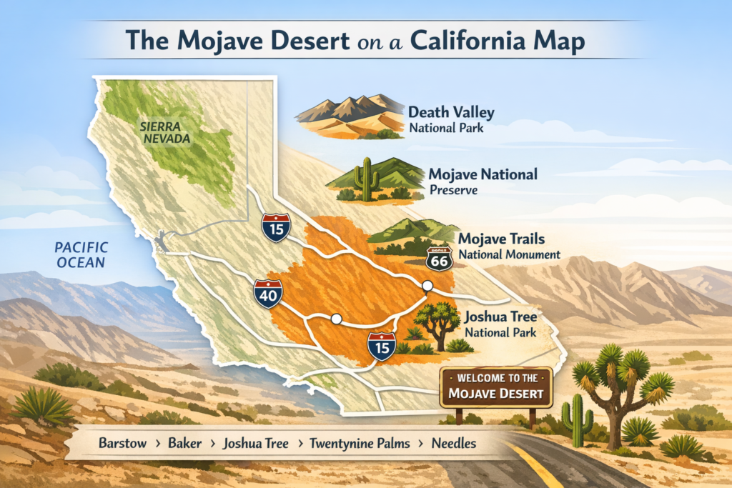
The Mojave Desert is one of California’s most important inland landscapes. On a map, it stretches across a vast high-desert region marked by mountains, highways, towns, and protected lands like Joshua Tree National Park and Mojave National Preserve. This guide helps you understand where it is, how to read it on a California map, and why it matters for travel and conservation.
What the Mojave Desert Means on a California Map
The easiest way to understand the Mojave Desert is to imagine California’s great inland desert belt. It lies east of the coastal mountain ranges and east of the Sierra Nevada, occupying a dry, elevated region that transitions into neighboring desert systems. On a state map, this makes the Mojave one of the clearest examples of how California changes from coastal and mountain environments into arid interior terrain.
What makes the region especially useful for map reading is its strong relationship with landmark places. Joshua Tree National Park marks the southern portion of the California desert story. Mojave National Preserve occupies a broad section of the interior desert between major highways. Death Valley shows the extreme northern side of the broader desert system. Mojave Trails National Monument connects the desert’s road history with some of its most rugged and remote country. These places are not just scenic highlights; they are geographic anchors.
A map of the Mojave is therefore not just a map of empty land. It is a map of elevations, routes, basins, mountain fronts, and protected landscapes. Once you know the most important anchors, the region becomes much easier to interpret. The highways tell you how people move through them. The parks show you which sections are preserved. The towns mark service points, trailheads, and historical corridors. The mountains and dry valleys show you why the desert climate exists in the first place.
The Mojave also matters because it is a transition zone. It does not exist as an isolated block with hard edges. It blends into the Great Basin Desert in the north and into the Sonoran Desert in the south and southeast. That means its map boundaries can appear slightly different depending on whether you are looking at an ecological map, a travel map, a highway map, or a county map. The desert is real even when the line around it is not perfectly sharp.
How to Read the Mojave Desert on a Map
A strong mental model helps more than anything else. If you want to read the Mojave Desert on a California map quickly, start with the big public lands and major roads, then work outward to towns, mountain edges, and desert basins.
| Map clue | What you should notice | Why it matters |
| Southeastern and interior California position | The desert is framed by ranges such as the San Gabriel and San Bernardino mountains in the southwest. | This is the fastest way to place the Mojave on a California map |
| Mountain boundaries | Joshua Tree, Mojave National Preserve, Death Valley, and Mojave Trails are major reference points. | These mountain fronts help explain the dry climate and rain shadow effect |
| Public land anchors | Joshua Tree, Mojave National Preserve, Death Valley, and Mojave Trails are major reference points | They give the desert clear locations for travel, ecology, and orientation |
| Major roads | I-10, I-15, I-40, CA-62, and Route 66 structure the region | The Mojave is a corridor as much as it is a landscape |
| Town networks | Barstow, Baker, Joshua Tree, Twentynine Palms, Yucca Valley, Needles, and Amboy help mark the desert. | These towns make it easier to understand distance and access |
A simple reading habit works well: first locate the parks, then identify the highways, then observe the mountain walls and travel towns. That sequence turns a huge, undefined desert region into a practical navigation framework.
Boundaries: Where the Mojave Starts and Ends
The Mojave Desert does not have a universally visible fence line, and that is one reason it is so often misunderstood. It is not a neat rectangle or a bounded administrative district. It is a large ecological and geographic zone that gradually connects with other desert regions. Britannica describes the Mojave as stretching from the Sierra Nevada to the Colorado Plateau and merging with the Great Basin Desert in the north and the Sonoran Desert in the south and southeast. It also notes the desert’s Relationship to the San Gabriel and San Bernardino mountains in the southwest.
Those boundaries matter because the Mojave is better understood as a transition landscape than as a flat, uniform void. Some parts are classic high desert, some areas are mountain-framed basins, and some stretches sit near major transport routes linking Southern California with Nevada and Arizona. In other words, the edge of the Mojave can feel ecological, topographic, or cultural depending on the context.
On some maps, the desert appears tightly defined. On others, it spreads more broadly across the interior. That difference is not an error; it reflects the fact that deserts are usually mapped by a combination of climate, vegetation, geology, and land use. The Mojave’s true identity is shaped by all four. The desert is broad in the center, softer at the edges, and strongly tied to mountain frontiers and dry basins rather than a single hard border.
This is why a person may open two different California maps and see slightly different Mojave outlines. The variation comes from the purpose of the map. An ecological map will draw one kind of boundary. A county or road atlas may draw another. A park map will show only the portion relevant to visitor access. The underlying landscape remains the same even when the border line shifts slightly.
Counties and Gateway Areas in the California Mojave
When people ask about the Mojave Desert at the county level, they are usually trying to translate a vast ecological region into a political or administrative framework. That is understandable, but it is important to remember that the desert does not obey county lines. Still, county groupings can be very helpful for orientation.
A Southern California desert map source identifies the Mojave Desert Air Basin as including desert portions of Kern, Los Angeles, Riverside, and San Bernardino counties. That framework is not the full ecological story of the Mojave, but it is a useful way to understand how widely the desert spreads across inland California.
For travel and map reading, the most useful areas are the gateway towns. These towns function as entry points, rest stops, supply centers, and orientation markers. They also make the desert legible because they sit near roads, park entrances, and scenic byways.
In the western and southern parts of the California Mojave, Joshua Tree, Yucca Valley, and Twentynine Palms are especially important because they surround Joshua Tree National Park and act as service hubs for visitors. Desert Hot Springs, Palm Springs, Cathedral City, Rancho Mirage, Palm Desert, Indio, Coachella, and Morongo Valley help readers understand the broader Coachella Valley and desert edge.
In the interior and northern stretches, Barstow, Baker, Daggett, Newberry Springs, Ludlow, Amboy, Goffs, Needles, and Mojave are key names. These towns appear again and again on official road and byway pages because they sit along historic travel routes and modern highway corridors. If you understand these places, you understand a large share of the California Mojave’s geography.
Cities and Towns That Help You Read the Mojave
The best way to think about the Mojave is not as one empty desert but as a network of hubs and connectors. Each town tells you something about access, direction, and distance.
Barstow is one of the most important anchors. It sits near the center of the desert transportation story and is closely associated with Mojave National Preserve access. It also connects to historic Route 66 travel patterns.
Baker is another major reference point. It is frequently used as a gateway town because it sits along Interstate 15 and offers a practical starting point for visitors entering the preserve or moving through the interior desert.
Joshua Tree, Twentynine Palms, and Yucca Valley are essential for understanding the southern Mojave and the area around Joshua Tree National Park. They are not just dots on the map; they are the towns where visitors find gas, lodging, restaurants, and access roads.
Needles, Goffs, Amboy, Ludlow, Newberry Springs, and Daggett help explain the Route 66 and eastern Mojave corridor. These settlements, some larger than others, show how the desert has long been crossed by people traveling between California, Arizona, and Nevada.
In the wider desert belt, Mojave itself, along with California City, Ridgecrest, and nearby communities in the inland desert region, also help readers understand how the desert functions as both a landscape and a living network of towns. The point is simple: the Mojave is not empty. It is populated, connected, and historically layered.
Roads, Highways, and Travel Corridors
Few places in California are as defined by roads as the Mojave Desert. The region is crossed by major interstate routes, state highways, historic byways, and older backcountry roads. On a map, these corridors are often the easiest way to understand the desert’s structure.
The major roads to remember are:
- Interstate 10
- Interstate 15
- Interstate 40
- California Highway 62
- Historic Route 66
For Mojave National Preserve, the official access pattern is especially useful. The preserve lies east of Barstow between I-15 and I-40. From the south and west, travelers often enter via Kelbaker Road, Zzyzx Road, Cima Road, or Nipton Road. From the north and east, access also comes from routes such as Essex Road and Goffs Road. That means the preserve is easy to place on a California map even before you physically arrive.
For Joshua Tree National Park, the road structure is just as clear. The park’s official access points include the West Entrance near Joshua Tree Village, the North Entrance in Twentynine Palms, and the South Entrance near Cottonwood Spring off Interstate 10, east of Indio. This road structure shows how the park sits between the Inland Empire, the Coachella Valley, and the broader eastern desert route network.
Historic Route 66 is another critical line. It runs through a string of desert towns that have become part of California’s travel identity. The Route 66 corridor helps visitors understand how the Mojave has long been not only a natural region but also a movement corridor linking settlement, commerce, and memory.
For practical map reading, the key is to recognize that the Mojave is shaped by movement. It is a desert of distances, junctions, pass-through towns, fuel stops, and long horizons. The roads are not just ways to get through the region; they are part of the region’s identity.
Important Road Names to Remember
The easiest road cues to keep in mind are these:
I-10 for access to Joshua Tree and the southern desert edge.
I-15 for access to Mojave National Preserve from the south and west.
I-40 for northern and eastern desert travel.
CA-62 for Joshua Tree and the western high-desert edge.
Route 66 for the historic corridor through Amboy, Ludlow, Newberry Springs, Daggett, and Barstow.
Each of these roads helps define the Mojave differently. Interstate highways provide modern movement. State highways connect local communities. Historic Route 66 adds cultural memory and tourism value. Together, they form the region’s travel skeleton.
Parks and Protected Lands That Define the Mojave
The Mojave Desert becomes much easier to understand once you connect it to its protected lands. These parks and monuments are not merely attractions; they are the clearest map anchors in the region.
Joshua Tree National Park
Joshua Tree is one of the most recognizable desert landscapes in the world. It is especially important because it sits at the meeting point of two desert systems. The park’s official materials highlight rich plant and animal life, cultural resources, and accessible entrances from several nearby towns. It is the best first stop for many people trying to understand the California Mojave.
Death Valley National Park
Death Valley shows the extreme side of the broader desert system. The National Park Service describes it as the hottest place on Earth and the driest place in North America. Its landscape includes below-sea-level basins, towering mountain ranges, exposed rock formations, and severe summer heat. On a map, Death Valley demonstrates the full scale and intensity of desert conditions.
Mojave National Preserve
Mojave National Preserve is one of the most important central anchors for the desert interior. It preserves a wide range of habitats and a long human history of desert use. Its location east of Barstow between I-15 and I-40 makes it especially useful as a geographic reference point. For many travelers, the preserve is the place where the Mojave’s openness, remoteness, and beauty become most obvious.
Mojave Trails National Monument
This monument is essential for understanding the road trip and historical geography of the desert. According to BLM, it spans 1.6 million acres and protects a major section of the historic Route 66 corridor, along with rugged mountains, lava flows, dunes, and remote desert terrain. It reinforces the idea that the Mojave is not only a natural landscape but also a transportation and heritage landscape.
Why these protected lands matter
These features make the Mojave Desert much easier to interpret on a map by turning a vast, open landscape into a set of clear reference points. They play a vital role in protecting wildlife habitats and fragile ecosystems while also guiding travelers with recognizable locations for navigation and route planning. At the same time, they reveal that the desert is not empty or lifeless, but a region rich in history, ecological diversity, and cultural significance.
Climate and Weather: Why the Mojave Feels So Different
The Mojave is a desert of contrasts. It is hot, dry, and bright, but it is also shaped by elevation, seasonal swings, and sharp temperature differences between day and night. Britannica describes the region as very dry, with hot summers, cool winters, frequent winter frosts, and major day-to-night temperature changes. Annual rainfall is extremely low, usually only a few inches.
Elevation changes make the climate more complex. In Mojave National Preserve, the land ranges from relatively low desert elevations to high mountain areas. That means temperature and precipitation can vary sharply across short distances. Lower areas are hotter and drier, while higher areas can be cooler and receive more moisture. In winter, higher elevations can even see snow.
Death Valley is the most dramatic example in the broader Mojave system. The park is famous for extreme heat, rare rainfall, and flash flood risk. That means weather planning is not optional. It is central to survival, comfort, and good travel judgment.
The practical lesson is that the Mojave does not operate as one uniform climate zone. It shifts with elevation, season, and time of day. A morning drive can feel pleasant, while the same location may be punishing by afternoon. A valley floor and a mountain pass may be only a short drive apart, but their weather can feel completely different.
This is one reason the region is called a high desert. The word “high” does not mean humid or mountainous in a narrow sense; it refers to elevation, temperature dynamics, and the ecological conditions that result from living at altitude in a dry environment.
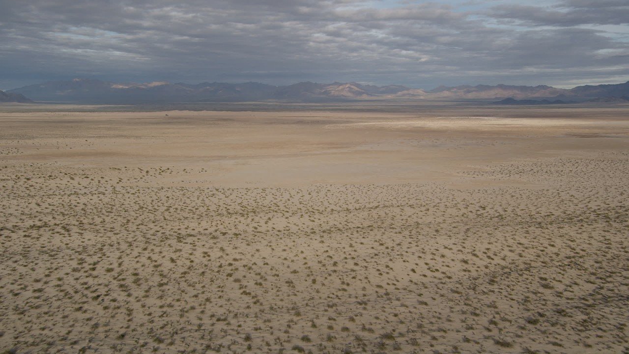
Landscape Features: Valleys, Mountains, Dunes, and Dry Basins
The Mojave is a landscape of texture. It is not one flat, monotonous stretch of sand. Instead, it is a large and varied terrain built from basins, ridges, uplifts, rocky slopes, dry channels, and open flats.
Britannica places the Mojave within a larger basin-and-range setting, which helps explain the repeated pattern of mountain blocks and low valleys. BLM also describes Mojave Trails National Monument as a combination of mountain ranges, lava flows, and dunes. That mix is central to the desert’s visual identity.
Within Mojave National Preserve, the official landscape categories are equally diverse. The preserve contains:
- creosote bush scrub
- Joshua tree woodland
- cactus-yucca scrub
- pinyon-juniper woodland
- desert riparian zones
- desert dunes
That variety shows how the Mojave changes with elevation and moisture. Lower areas tend to be more open and sparse. Higher areas support different trees and shrubs. Riparian zones appear where water exists for at least part of the year. Dunes create a dramatic visual counterpoint to the surrounding rocky terrain.
One of the best examples is the Kelso Dunes, which are famous for their scale and striking appearance. Sand in the desert is not always a broad sea of dunes. In many places, it is concentrated into impressive formations that create unique habitats and travel challenges.
The broader physical landscape also includes canyons, passes, alluvial fans, and dry lake beds. These features show that the Mojave is dynamic, not static. Wind, water, tectonic uplift, and erosion have shaped it over millions of years. That is why a map of the Mojave should be read like a topographic story, not just a political outline.
Flora: The Plants That Make the Mojave Famous
The Mojave is strongly associated with a few iconic plants, but its botanical diversity is much richer than many people realize. The most famous plant is, of course, the Joshua tree. It has become the symbolic signature of the desert and one of the most recognizable plant forms in North American geography.
But the Mojave’s plant life extends far beyond that single species. In Joshua Tree National Park, the National Park Service notes a rich and varied plant community that includes desert lavender, creosote, cactus species, palm trees, pine trees, and many rare species. That combination reflects the ecological meeting point between low desert, elevated terrain, and transitional habitats.
In Mojave National Preserve, vegetation changes noticeably with elevation. Higher locations support white fir, juniper, and pinyon pines, while lower areas support yuccas, Joshua trees, and cholla. This is one of the clearest examples of how the Mojave’s plant life responds to altitude and moisture.
The seasonal cycle is also important. Many annual desert plants grow rapidly during the cooler, wetter winter and spring months, then complete their life cycles before the summer dryness becomes too intense. This creates bursts of color and life that can transform the appearance of the desert for a short time.
Joshua Tree National Park also offers a useful biodiversity benchmark. The park protects hundreds of plant species, alongside a large array of birds, mammals, and reptiles. That fact alone is enough to challenge the stereotype that deserts are botanically poor. In reality, the Mojave is a place of highly specialized vegetation, adapted to intense light, low water, and temperature stress.
Fauna: Wildlife in the Mojave Desert
The Mojave supports a surprisingly rich and resilient animal community. Its animals survive through nocturnal behavior, burrowing, heat management, migration, camouflage, and specialized feeding patterns. Many of the region’s most iconic species are adapted to long periods of dryness and strong temperature swings.
In Joshua Tree National Park, the wildlife list includes kangaroo rats, coyotes, foxes, bobcats, bighorn sheep, mule deer, bats, and many reptiles and birds. These animals reveal that the desert is not empty at all. Much of its life simply moves on a different schedule than humans do.
One of the most important species in the Mojave is the desert tortoise. Mojave National Preserve explains that tortoise populations have faced long-term decline due to habitat loss, disease, and human disturbance. The species is especially vulnerable to roads and vehicles. Because tortoises move slowly and rely on intact habitat, even a single road can become a major threat.
This is why wildlife is also a map issue. Protected lands, road networks, and growing communities all affect how animals move through the desert. Travel corridors help humans, but they can fragment habitat if not managed carefully. Conservation planning, therefore,e becomes part of map planning.
The Mojave’s animal life is a strong reminder that the desert is a functioning ecosystem. It contains predators, prey, pollinators, reptiles, birds, small mammals, and species that depend on water sources and sheltered areas. What seems sparse at first glance is actually a finely tuned web of life.
Human History and Culture in the Mojave
The Mojave has a deep human history that stretches back thousands of years. The National Park Service says that Mojave National Preserve holds 10,000 years of human connection with the desert, which is an extraordinary reminder that this place has long been part of human life, movement, survival, and meaning.
Joshua Tree National Park’s official materials identify the region as part of the traditional homelands of the Serrano, Cahuilla, Chemehuevi, and Mohave peoples. Other NPS pages describe the park as part of the ancestral homeland of the Maara’yam (Serrano), Nüwü (Chemehuevi), Kawiya (Cahuilla), and Aha Macave (Mohave). These names matter because they shift the story from a generic landscape narrative to one rooted in Indigenous continuity and stewardship.
The desert was also part of broader trade and travel systems long before modern highways arrived. The Oasis of Mara and other water-linked sites were important in regional movement and exchange. Far from being isolated, the Mojave was connected to cultural and economic networks across the Southwest.
Later layers of history added mining, railroads, homesteading, military activity, tourism, and the rise of Route 66 culture. The modern conservation story accelerated with the California Desert Protection Act of 1994, which created Mojave National Preserve and elevated Joshua Tree and Death Valley to national park status. That legal turning point permanently changed how the desert appears on the map.
This is why the Mojave is more than scenery. It is a place of Indigenous heritage, pioneer travel, road culture, conservation policy, and public-land management. Any good California desert map should show those layers, not just the terrain.
Best Way to Plan a Mojave Desert Trip
The best time to visit the Mojave is usually spring or fall. Those seasons generally offer the most comfortable conditions for driving, hiking, and sightseeing. Summer heat can become severe, especially in lower elevations, and winter nights can be surprisingly cold at higher elevations.
The safest approach is to plan around distance, water, and road conditions. Desert travel requires more preparation than many other kinds of road trips. You should always expect fewer services, larger gaps between towns, and long stretches of open highway.
Before leaving, use the current official maps and road information. The National Park Service warns visitors not to rely on inaccurate third-party navigation tools when planning preserve travel. Some roads are paved but still rough, and others are dirt or remote routes that may require high-clearance vehicles or four-wheel drive.
Smart desert travel habits
- Carry more water than you think you need.
- Check official road and weather conditions before departure.
- Fuel up before entering long, remote stretches.
- Assume that cell service may be weak or absent.
- Know your exit route before you start hiking or driving off the main highway.
The essential idea is simple: in the Mojave, preparation is part of the experience. Good planning makes the trip safer, more comfortable, and more rewarding.
Example Routes and Travel Ideas
There are several easy ways to organize a Mojave Desert trip on a California map.
Classic park route
Start with Joshua Tree National Park, then explore nearby towns such as Joshua Tree, Twentynine Palms, and Yucca Valley. This route is ideal for first-time visitors because the park entrances and service towns are clearly marked and easy to access.
High-desert preserve route
Begin in Barstow and move toward Mojave National Preserve using access roads from I-15 or I-40. This route is excellent for travelers who want to understand the high-desert interior, wide-open spaces, and more remote public lands.
Historic road-trip route
Follow the Route 66 Needles to Barstow Scenic Byway and connect towns such as Needles, Goffs, Amboy, Ludlow, Newberry Springs, Daggett, and Barstow. This is one of the best ways to experience the Mojave’s transportation history, abandoned roadside atmosphere, and heritage landscape.
These routes are valuable because they show the desert as a sequence of connected places. The Mojave makes the most sense when you move through it one anchor point at a time.
Interesting Facts About the Mojave Desert
The Mojave is known as a high desert, and that description is accurate because elevation strongly influences the region’s climate and ecology. Higher areas in the preserve support different plant communities than lower basins. That variation makes the desert far more diverse than many people expect.
Another important fact is that the Mojave is a transition zone. It merges with the Great Basin in the north and the Sonoran Desert in the south and southeast. That helps explain why it contains such a mix of landforms, species, and ecological patterns.
A third fact is the scale of protection. The Mojave includes huge public lands, such as Mojave National Preserve and Mojave Trails National Monument. These protected areas cover immense territory and preserve both habitat and history.
A fourth fact is that the Mojave is one of California’s most legible desert regions. Once you learn the parks, roads, and gateway towns, the map becomes much easier to understand. It stops being a blank region and becomes a connected system.
A fifth fact is that the desert has both beauty and severity. It can be stunningly scenic and physically unforgiving at the same time. That contrast is part of what makes the Mojave so memorable.
Environmental Issues and Conservation
Even though much of the Mojave is protected, the region still faces real environmental pressures. Development, invasive species, road hazards, climate extremes, and habitat fragmentation all affect desert systems. Conservation is therefore a major part of the Mojave story.
One of the most important species concerns is the desert tortoise. Road mortality, habitat disruption, and other human impacts can seriously affect tortoise populations. Because of this, transportation management and conservation policy are closely linked in the desert.
Invasive plants are another concern. They can spread into fragile habitats and alter fire patterns, soil conditions, and native plant competition. That is a major issue in desert ecosystems where native plants are already adapted to very specific conditions.
Road safety and habitat protection also overlap. Highways and rough roads are part of the desert’s identity, but they can also fragment wildlife corridors. The result is a constant balancing act between access and protection.
Conservation in the Mojave is not only about wildlife. It is also about preserving the landscape’s readability, cultural continuity, and visitor access. Good management keeps the desert understandable for future generations and ensures that its natural and historical value remains intact.
Pros and Cons
Pros
The Mojave offers some of the most iconic desert scenery in California, including Joshua trees, dunes, mountain ranges, and dramatic open basins.
It is one of the easiest desert regions to understand on a map because major parks, highways, and towns form strong orientation points.
The region has a deep history, visible Route 66 heritage, and major protected lands that make it compelling for road trips and nature travel.
Cons
Summer heat can become dangerous, especially in lower elevations and in extreme places like Death Valley.
Many areas have limited services, long distances between fuel stops, and rough roads that are not suitable for every vehicle.
Cell coverage, shade, and quick emergency help can be limited, so planning matters more here than in urban travel.
FAQs
The Mojave Desert is mainly in southeastern California and the inland desert region of the state. It stretches across a broad area east of the coastal ranges and the Sierra Nevada, with major California anchors including Joshua Tree National Park, Mojave National Preserve, and Death Valley National Park. On a California map, it appears as a large desert belt tied to highways, mountain fronts, and protected lands.
A Southern California desert map source identifies desert portions of Kern, Los Angeles, Riverside, and San Bernardino counties as part of the Mojave Desert Air Basin. That gives a useful county-level framework for understanding the California side of the Mojave, even though the desert itself does not stop at county lines.
Important city and town anchors include Barstow, Baker, Joshua Tree, Twentynine Palms, Yucca Valley, Needles, Goffs, Amboy, Ludlow, Newberry Springs, and Daggett. These places appear repeatedly in park access pages and historic Route 66 references because they help define how people enter, cross, and understand the desert.
The major protected-land anchors are Joshua Tree National Park, Death Valley National Park, Mojave National Preserve, and Mojave Trails National Monument. Together, they shape the most recognizable parts of the desert and make the region much easier to read on a California map.
It is called a high desert because much of it sits at an elevated terrain, which affects temperature, moisture, and vegetation. Higher locations in the Mojave can support different plants and climate conditions than lower valleys. The desert is still extremely dry, but its elevation makes it distinct from lower-elevation deserts.
The Mojave is unique because it combines Joshua trees, desert tortoises, mountain fronts, Route 66 history, broad public lands, and major elevation changes. It is both an ecological region and a travel region. It is also a transition zone that connects with other desert systems, which gives it an unusually diverse landscape character.
Conclusion
The Mojave Desert is more than a desert shape on a map. It is a connected region of roads, parks, towns, wildlife, and dramatic scenery. Once you know its key anchors, it becomes much easier to Understand and explore.