Introduction
The Taklamakan Desert sits in the centre of the Tarim Basin and is one of the world’s largest sand seas. It has framed human history along the Silk Road, preserves remarkable archaeology, and presents clear logistical challenges for anyone planning fieldwork or overland travel. This long-form, conversion-friendly guide bundles maps, an easy month-by-month climate breakdown, archaeology and ethics, travel planning, and a product funnel for free A0 preview maps plus a premium researcher pack (GeoTIFF/MBTiles/GPX)
Where is the Taklamakan? Geography, basin setting and neighbouring ranges
The desert sits within the broad endorheic bowl of the Tarim Basin. A closed hydrological basin, the Tarim receives meltwater and ephemeral rivers from ringed mountain chains and traps sediments, sand, and salts. Key massifs and ranges that form the basin rim are the Kunlun Mountains to the south, the Tian Shan to the north, and the Pamir Mountains to the west. Farther east and northeast lies the broad Gobi Desert — a different arid system, but one that helps define regional climate gradients.
Because the basin is ringed by high, often glaciated ranges, most moisture falling on those mountains precipitates out and runs into internal rivers (e.g., the Hotan and Yarkand systems) rather than reaching the sea. The rain-shadow and steady fluvial sediment supply are why a huge sand sea accumulated in the middle of the Tarim Basin.
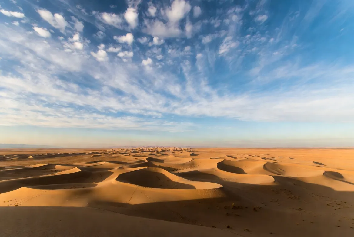
Size & shape: The Taklamakan runs roughly 900–1,000 km east–west and is commonly quoted at about 320,000–337,000 km² — comparable in area to medium-sized countries. The interior is dominated by mobile dunes and sand sheets; the margins are where rivers drop alluvial fans and support narrow oasis belts.
Towns & oases to know: On the desert margins, you’ll find oasis towns and supply hubs — for example, Hotan, Yutian, and Ruoqiang. These are the principal service points, fuel stops, and cultural gateways for journeys that brush the dunes.
How the Taklamakan formed — tectonics, sediment supply and wind
The modern sand sea is the product of three interacting long-term processes:
- Tectonics and uplift. Uplift of the Tibetan Plateau and the surrounding orogens (Kunlun, Tian Shan, Pamirs) created a high barrier that blocks moist air from low latitudes, producing a persistent rain shadow over the Tarim Basin. Over millions of years,s the highlands have continued to rise and erode, supplying material to the basin.
- Fluvial sediment delivery. Streams running off the surrounding ranges carry gravel, silt and sand into the basin. During wetter epochs, the rivers filled lakes and built fertile alluvial plains; during drier times, the fine sediment was remobilised by wind and concentrated into dunes.
- Aeolian shaping. Prevailing winds sort and move sediments into linear and star-shaped dunes and into large sheets. Where sand supply is Abundant and vegetation scarce, dunes are tall and mobile; where water or human planting stabilises the surface, interdune flats and shrublands appear.
Paleoclimate records — lake cores, pollen and loess sequences — show that the Tarim has alternated between intervals of increased moisture and more arid conditions. During wetter phases, lakes like Lop Nur expanded and supported denser human occupation. During dry phases, oasis towns contracted or were abandoned, and dunes advanced.
Map assets you should include
A modern, conversion-oriented article or product page should offer both an immediately useful free preview and a full premium data pack. Typical map assets:
- Free A0 preview (300 dpi) — a high-contrast wall map that shows the desert outline, main towns, the Tarim Desert Highway, major ruin sites, and a few photographic inset areas. Use this as a lead magnet (email capture).
- GeoTIFF mosaic (EPSG:4326) — georeferenced raster tiles or a stitched mosaic for GIS users; essential for academic or consultancy buyers.
- MBTiles offline pack — tiled basemap suitable for mobile mapping apps (works offline; great for overlanders).
- GPX routes and waypoints — vetted tracks with emergency coordinates, fuel points, and permit notes.
- Optional overlays — dune morphology, seasonal NDVI (vegetation index), derived contour layers from SRTM, and monthly climate heatmaps.
Include a clear README with sources, projection, acquisition dates, licensing, and how to cite the materials.
Quick facts — at a glance
- Area: ~320,000–337,000 km²
- East–West length: ≈900–1,000 km
- Climate: cold desert — very hot summers, very cold winters, large diurnal ranges
- Main engineered route: Tarim Desert Highway
- Famous palaeolake: Lop Nur
- Principal oasis towns: Hotan, Yutian, Ruoqiang.
- Peak archaeological & Silk Road interest: Loulan, Niya, Miran, Gaochang, Dandan-Oilik. (See below.)
- Best months for most travellers: late September–October.
Climate & weather — month-by-month practical guide
The Taklamakan’s cold desert climate produces extremes. Winds in spring create dust hazards; summer brings searing heat in the lowlands while the nights remain cool; winter can drive temperatures well below freezing.
Below is a compact month table aimed at planners. (Use absolute dates when you schedule trips; local seasonal timing can vary.)
Tip: Spring dust storms (March–April) can cancel low-visibility travel for days. Always plan buffer days and have alternate routes.
Landscape & landforms — what you’ll actually see
The Taklamakan is mostly sand but contains a mosaic of geomorphic features:
- Dune sea: Linear, crescentic and star dunes dominate large tracts; heights commonly range 20–100 m.
- Interdune flats: Low-lying, sometimes vegetated surfaces between dunes.
- Alluvial fans & river plains: At the desert margins where rivers exit mountain canyons, these support oases and agriculture.
- Salt flats/palaeolakes: Lop Nur is the most famous, an extensive flat salt pan marking a desiccated lakebed.
- Oasis belts: Narrow, fertile strips along river courses where towns and farming survive.
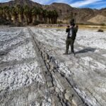
- Engineered corridors: Sections of buried or sand-drifted roads like the Tarim Desert Highway show extensive human investment to keep routes open.
For mapping, present dune morphology layers and a seasonal NDVI to help users see how green the margins become in wet years.
Vegetation & wildlife — life at the margins
The heart of the sand sea is mostly barren. Life concentrates on margins, river corridors, and interdune refugia.
Plants:
- Saxaul (Haloxylon spp.) — a shrub-tree commonly used in stabilisation projects.
- Desert poplar along riverbanks.
- Salt-tolerant shrubs and grasses on playa margins.
Animals:
- Small rodents and desert-adapted mammals.
- Migratory and breeding birds using oasis corridors.
- Reptiles and numerous arthropods adapted to arid substrates.
- Historically, fringe areas supported wild Bactrian camels; numbers now are limited.
Large state-led afforestation and sand-control efforts have planted millions of trees and shrubs. These stabilise dunes but use substantial water and require maintenance; that trade-off is crucial for planners and conservationists.
Human history & archaeology — Silk Road, mummies and ancient towns
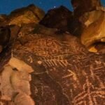
Fringes of the basin were once active Silk Road corridors. Traders linked China to Central Asia, the Middle East and beyond, moving goods like silk, spices, ceramics and precious stones through oasis towns. Archaeological preservation in the dry basin has produced well-preserved textiles, wooden artefacts, manuscripts and natural mummies — materials that have been crucial for understanding long-distance cultural contact.
Notable excavations and sites include Loulan, Niya, Miran, Gaochang and Dandan-Oilik. Early 20th-century expeditions led by explorers like Aurel Stein recovered many artefacts that now reside in museums around the world — a provenance history that is important and often contested.
Conservation note: Many sites are fragile and easily damaged. When publishing maps or route packs, include robust ethical guidance: do not direct users to unsanctioned visits; provide permit contacts; encourage in-situ recording protocols and digital preservation (e.g., photogrammetry, 3D scanning) rather than encouraging physical collection.
Lop Nur — the palaeolake with layered stories
Lop Nur was previously an extensive lake system stretching across the eastern Tarim. Over time, it contracted and turned into a series of salt flats and playa ponds. Lop Nur features in archaeology, modern science, and 20th-century history (including resource extraction and military testing in some periods). It is often a focal point for paleoclimate studies because lake sediments preserve long-term environmental proxies.
When marking Lop Nur in GPX packs and maps, annotate conservation sensitivities and access restrictions. Some areas are scientifically sensitive or regulated; users must be warned.
Modern developments — roads, green belts, and renewable energy
China has invested heavily in infrastructure and land management around the basin:
- Roads and rail: Engineered highways and rail corridors improve margin access; the Tarim Desert Highway is an engineering landmark but requires constant sand control.
- Afforestation and sand control: Large belts of planting have been installed to slow dune advance and protect infrastructure. These programmes stabilise soils but have high water demands and maintenance costs.
- Renewables: The wide open, sunny basin margins are attractive for solar farms and other renewable projects.
These developments facilitate safer travel and create new mapping needs — for example, up-to-date road vectors and construction footprints in the GeoTIFF/MBTiles.

Travel logistics — permits, vehicles and communications
Travel in or around the Taklamakan is possible but requires careful preparation.
Permits & legalities: The desert is in the Xinjiang region (an autonomous region with specific entry rules). Permit and travel restrictions can change; foreign travellers and researchers must check consular advice and local permit offices prior to travel.
Vehicle & kit checklist:
- High-clearance 4×4 with roof rack.
- At least two spare tyres and a robust recovery kit (snatch straps, shackles, winch or recovery boards).
- Extra fuel jerry cans sized to planned legs.
- GPS with offline MBTiles, a verified GPX route, and paper maps as a redundancy.
- Satellite communicator (Iridium, satellite messengers) or a Beidou-capable device for local compatibility.
- Water: plan >5 L per person per day for desert legs; cache points for longer transits.
- Shelter: shade, wind protection, and cold-weather layers for nights.
- Medevac insurance and evacuation plan for remote rescue.
Communications & emergency: File an itinerary with a local contact; identify the nearest towns and services on each route segment. Know where fuel and medical services exist along the Tarim Desert Highway and in oasis towns.
Sample itineraries
3-day margin run (fast): Hotan → Tarim Desert Highway highlights → Yutian → return. Useful for short field checks or photography.
7-day researcher route (detailed): Hotan → Lop Nur perimeter → Niya → Miran → Ruoqiang approach. Needs local permits, archaeological permission where relevant, and fuel/water caches. Hire local guides.
Notes: Deep off-road crossings across the central sand sea require professional logistics and local liaison; these are high-risk and should not be attempted without significant support.
GPX, MBTiles & printable A0 map pack — structure and contents
Free lead magnet
- Simple, printable A0 PDF (300 dpi): main towns, Tarim Desert Highway, sample ruin locations, and a small legend. Use as a visible CTA near the top of the article.
Premium researcher pack
- GeoTIFF mosaic (EPSG:4326) covering the Tarim Basin. Include multiband imagery where possible and a clear date stamp.
- MBTiles set targeted at zooms for 1:50k and 1:100k use.
- GPX routes: waypoints for fuel, medevac coordinates, vetted camp locations, and archaeological zones flagged as restricted.
- Derived layers: contour from SRTM, seasonal NDVI rasters, and dune morphology maps.
- README and metadata: source lists (SRTM/ASTER/Sentinel/Landsat), data dates, processing steps, licensing and citation guidance.
Licensing & metadata: Always include source attribution and licensing in the README. If you adapt public imagery, note the exact dataset and date. For commercial sales, ensure you have the correct redistribution rights.
Map asset comparison
| Asset | Use case | File type | Pros | Cons |
| A0 printable map | Wall or desk reference | PDF/PNG (300 dpi) | High-impact; good lead magnet | Large file, not interactive |
| GeoTIFF mosaic | GIS analysis | GeoTIFF (EPSG:4326) | Georeferenced, high detail | Large and needs GIS tools |
| MBTiles | Offline navigation | MBTiles | Compact; mobile-friendly | Requires tile viewer app |
| GPX routes | Trip planning | GPX | Simple and widely supported | No basemap or imagery included |
| Seasonal overlays | Planning by month | PNG/GeoTIFF | Quick visual comparison | Needs a basemap for context |
Archaeology & ethics — how to handle fragile heritage
Archaeological sites in the basin are often extremely fragile. When you provide maps and route packs:
- Don’t encourage off-track visits to unsanctioned ruins.
- Provide permit and contact details for site stewards and local authorities.
- Advocate digital preservation: encourage users to record with non-invasive methods (photogrammetry, 3D scans) and to share data with site stewards.
- Be transparent about provenance: many early excavations removed finds from the region — discuss the history openly and direct readers to current museum policies and repatriation conversations.
In product copy, include a clear ethics statement and a simple checklist for respectful site interactions (stay on signed paths, photograph without removing objects, report finds to local authorities).
Survival tips & vehicle maintenance in sand
Sand & machinery: Sand is abrasive — check and replace air filters frequently; pack spare filters if you’ll push the gear hard. Keep seals lubricated and protect moving parts.
Navigation: Dunes are featureless; rely on vetted GPX tracks and allow margin buffers for route-finding. Having a second experienced driver or local guide reduces single-point failure risk.
Temperature swings: Nights can be cold even after hot days. Pack layered clothing.
Water: Surface water is rare and unreliable. Treat wells or water sources only if documented; otherwise, plan for carried supplies.
Local liaison: Hiring local drivers or guides pays dividends. They know current track conditions, permit procedures, and informal water/fuel caches.
Tourism & activities — ethically fun and safe options
- Visit oasis towns for markets (silk, jade), food, and cultural exchange.
- Photograph dunes at sunrise and sunset — soft light reveals dune texture.
- Visit archaeological parks and museums where permitted, and join guided tours.
- Drive engineered corridors like the Tarim Desert Highway for a desert experience without the highest risk.
- Learn about and respect local cultures — many oasis towns are home to the Uyghur people with distinct customs.
Advice: Use reputable operators, ensure transparent pricing, and ask about environmental and cultural safeguards.
Environmental trade-offs & conservation choices
Afforestation and sand control reduce dune movement and protect infrastructure, but require irrigation and maintenance. That creates trade-offs with groundwater and long-term sustainability. Conservation planning must balance local livelihoods, water budgets, archaeological protection, and regional dust emissions (which can affect climate and air quality hundreds of kilometres downwind).
Monetisation & funnel ideas
Top-of-funnel: Free A0 preview (lead magnet) — visible CTA near top of article to increase conversions.
Middle-of-funnel: Paid researcher pack (GeoTIFF + MBTiles + GPX) — sell to academic users, consultancies, and overlanders.
Add-ons: Custom GPX editing, bespoke route-checking, or field support.
Content upgrades: Monthly climate datasets, 3D models of notable sites, or detailed permit guides.
Make sure all products include a clear README, licensing, and citations. For academic buyers, provide DOI-style citation metadata or an ORCID contact.
Example GPX waypoint list
- Hotan — services, last fuel before long desert legs. (Use town coordinates in GPX metadata.)
- Tarim Desert Highway milepost — main engineered corridor and emergency access.
- Niya ruins — archaeological site; include permission notes.
- Lop Nur edge — palaeolake observation; mark conservation restrictions.
- Ruoqiang approach — exit point and services.
Pros & Cons
Pros
- Exceptional archaeological preservation (texts, textiles, mummies).
- Dramatic dune landscapes for photography.
- Rich opportunities for paleoclimate and ecological research.
- Increasing availability of satellite data and open-source layers.
Cons
- Remote, harsh environment that demands serious logistics.
- Permit and political sensitivities for foreign researchers and travellers.
- Fragile sites that are easy to damage.
- High water demands forgreening/afforestation efforts.
FAQs
A: The Taklamakan Desert sits in the central Tarim Basin of southern Xinjiang in northwest China, between the Kunlun range to the south and the Tian Shan to the north.
A: Late September–October is usually most comfortable. Spring brings dust storms, and summer has extreme heat.
A: Yes. The Tarim Desert Highway and other engineered roads cross the margins. Long off-road crossings are risky and need local support, permits, and experience.
A: Offer a gated free A0 PDF preview on your site. Sell a premium pack (GeoTIFF + MBTiles + GPX) for researchers and overlanders. Include metadata and licensing.
A: Yes. Well-preserved human remains and textiles were found in the basin and are important for understanding ancient Eurasian contacts.
Conclusion
The Taklamakan Desert is more than a vast sand sea. It’s a palaeoenvironmental archive, a corridor for ancient exchange, and a modern fieldwork challenge. For publishers and researchers, there is a clear content and product gap: numerous authoritative sources exist, but few combine practical month-by-month climate guidance, research-grade map assets (A0/GeoTIFF/MBTiles/GPX), ethical archaeology guidance, and a conversion-optimised funnel.