Introduction
The Mojave Desert is one of California’s most important desert regions, and a map makes it much easier to understand. It shows where the desert is located, which cities and counties it touches, and what natural landmarks help define its boundaries. This guide gives you a clear picture of the Mojave Desert in California.
Quick Map Overview of the California Mojave Desert
Before going deep, it helps to build a compact semantic snapshot of the region.
| Map Element | What It Shows | Useful Anchor Points |
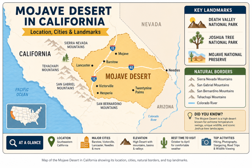
| California core | The Mojave is mainly a southeastern California desert region. | Barstow, Victorville, Hesperia, Lancaster, Mojave, Twentynine Palms, Needles |
| Neighboring states | The desert does not stop at California’s border. | Nevada, Arizona, Utah |
| Natural borders | Mountains help define where the desert begins and ends. | Sierra Nevada, San Gabriel Mountains, San Bernardino Mountains, Tehachapi Mountains |
| Map layers | Different maps use different boundary logic. | County maps, air-basin maps, land-management maps |
| Key visitor landmarks | The easiest places to recognize on a travel map. | Death Valley, Joshua Tree, Mojave National Preserve |
The main idea is straightforward: the Mojave Desert in California is not a neat circle, not a single city, and not a fixed box with hard edges. It is a broad desert region with soft transitions. Some maps emphasize ecology, some emphasize county lines, some emphasize roads, and some emphasize visitor landmarks. A strong reader of the region must combine these layers rather than rely on just one.
What Is the Mojave Desert?
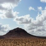
The Mojave Desert is a high-desert region in the southwestern United States. It is known for dry air, open horizons, rugged mountain-and-basin structure, extreme temperature variation, and a distinctive ecological identity. It is one of the most famous desert landscapes in North America because it combines aridity with dramatic topography and iconic natural landmarks.
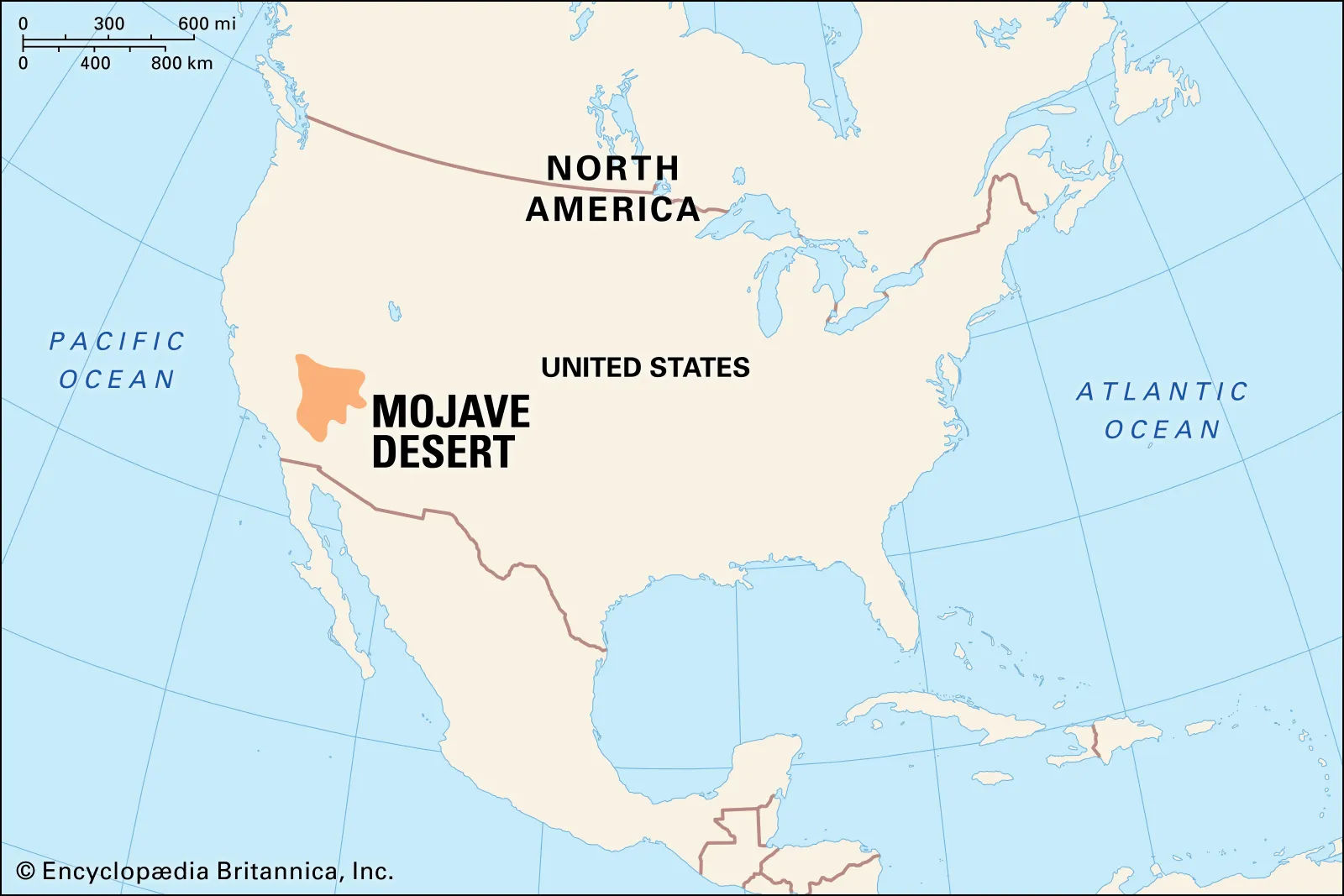
On a California map, the Mojave Desert sits largely in the southeastern part of the state. The Mojave Desert lies inland rather than along the coast. This region forms part of the wider California desert system, but it does not represent the entire desert landscape of the state. The Mojave is a clearly defined geographic and ecological zone that connects with neighboring desert regions and surrounding mountain barriers.
Version 2:
The Mojave Desert is located inland, away from coastal areas. This desert belongs to the broader California desert system, yet it should not be considered all of California’s desert terrain. The region is a distinct geographic and ecological area that links with nearby deserts and mountain ranges.
Version 3:
The Mojave Desert sits inland instead of near the coast. This desert region is included within the larger California desert system, but it does not cover all desert areas in the state. The Mojave region. A common misconception is that the Mojave is just a flat field of sand. That idea is too narrow. The real desert includes mountain ridges, dry basins, playas, salt flats, canyons, gravel plains, volcanic formations, valleys, dune fields, scrubland, and Joshua tree habitat. In other words, it is a multi-layered environment rather than a single texture. The map matters because it lets you see those layers as a spatial system instead of as isolated facts.
Where Is the Mojave Desert on a California Map?
The Mojave Desert sits in southeastern California, mostly inland and east of the Los Angeles metropolitan area. It is part of the larger desert interior of the American Southwest and lies at the intersection of several natural systems.
If you place it on a California map, the Mojave Desert appears roughly:
east and northeast of Los Angeles
north of the lower Colorado River area
west of the Nevada and Arizona desert regions
south of the Great Basin transition zone
within the Sierra Nevada rain-shadow influence
A practical mental image is to picture the Mojave as a desert corridor across inland Southern California. It stretches through the High Desert and farther east and north toward major landmark zones like Death Valley and Mojave National Preserve.
A simple way to picture it is to start with a few real-world anchors:
Barstow
Mojave
Lancaster
Victorville
Hesperia
Twentynine Palms
Needles
Death Valley
These place names act like semantic tokens. They help the reader locate the region on a map, understand movement across it, and connect the abstract label “Mojave Desert” to navigable geography.
What States Does the Mojave Desert Cover?
The Mojave Desert is not limited to California. It extends into several states.
The region covers parts of:
California
Nevada
Arizona
Utah
California contains the largest and most widely Recognized portion of the desert, which is why the keyword California map of the Mojave Desert is so useful. But the natural region itself does not obey political boundaries. It follows elevation, climate, geology, and ecological transition rather than state lines.
That is one of the most common mapping errors people make. They assume that a desert must fit neatly into a single administrative unit. The Mojave does not. It is a regional system, not a political shape.
Which California Counties Are in the Mojave Desert?
There is no single county list that fits every map, because the Mojave is defined differently depending on whether the map is ecological, administrative, scenic, legal, or travel-oriented. Even so, several California counties are strongly associated with the desert region.
Commonly referenced desert portions include:
Inyo County
Kern County
Los Angeles County
San Bernardino County
Riverside County
Imperial County
Some land-use and environmental mapping systems highlight only the desert portions of these counties rather than the full county footprint. That distinction matters because counties can contain both desert and non-desert environments. In other words, the region is often a partial overlap rather than a full-county match.
This is also why county-based queries are so common. Readers often want to know not just where the Mojave sits, but which county they are in when they pass through, visit, or plan a route.
Which California Cities Are in or Near the Mojave Desert?
The best way to understand the California map of the Mojave Desert is through city anchors. Cities create a usable spatial model. They transform a broad ecological region into a set of recognizable points.
Important cities and towns include:
Barstow
Victorville
Hesperia
Lancaster
Mojave
Twentynine Palms
Needles
Apple Valley
Adelanto
Bishop-area transition points in broader desert mapping
Mojave-adjacent High Desert communities
Why city anchors matter
A map that only shows a border outline can feel abstract. A map that includes towns and cities gives the user something concrete to hold onto.
For example:
Barstow works as a major gateway and junction point.
Victorville and Hesperia help define the High Desert edge.
Lancaster shows the western reach of the desert region.
Twentynine Palms links the desert to Joshua Tree and eastern travel routes.
Needles gives a strong eastern reference near the Colorado River corridor.
Mojave is especially important because it appears both as a town name and as a desert-region name, which can confuse searchers.
These city names function like geographic labels inside the larger map. They reduce ambiguity and improve orientation. If the reader can place the city, the desert becomes easier to understand.
What Borders the Mojave Desert?
The Mojave Desert sits in a transition zone. It does not have a hard wall around it. Its margins are shaped by mountains, elevation gradients, moisture patterns, and neighboring desert systems.
Main natural borders and transition zones
The northern edges of the Mojave Desert connect with the Great Basin Desert.
Southern and southeastern areas transition into the Sonoran Desert.
Western and southwestern sides are shaped by mountain systems that block moisture and increase dryness.
The Tehachapi Mountains mark an important boundary along the northwest.
The Sierra Nevada plays a major role in creating rain-shadow conditions.
The San Gabriel Mountains and San Bernardino Mountains help frame the southern edge of the California desert region.
This is why different maps show slightly different Mojave boundaries. A geologic map, an ecological map, a land-management map, and a travel map are not trying to solve the same problem. Each has its own lens, its own scope, and its own boundary logic.
The most accurate way to think about the Mojave is as a living region with soft edges, not as a box with perfectly crisp lines.
Why the Mojave Desert Is Called a High Desert
The Mojave is often called a high desert, and that description is meaningful. “High” does not refer only to heat or dryness. It refers to elevation.
Much of the Mojave sits at relatively higher elevations compared with the low desert zones. That affects almost everything: temperature, rainfall, plant structure, seasonal behavior, winter frost, habitat zones, and even how far people can travel safely in different months.
Why elevation matters
Elevation influences:
temperature
frost patterns
plant growth
water retention
animal habitats
winter weather
Snow in certain zones
This is part of why the Mojave can feel hot in summer and surprisingly cold at night in winter. The climate is not uniform across the whole region. It changes with altitude, slope, basin depth, and proximity to mountain systems.
The desert includes lower basins, higher plateaus, mountain slopes, dry valleys, and transition zones. That variation is one of the reasons the California map of the Mojave Desert is so useful: it helps the reader see the internal structure instead of assuming a flat surface.
Mojave Desert Climate and Weather Patterns
The Mojave Desert has a classic desert climate, but its weather is more nuanced than many people assume.
Main climate features
are very low rainfall.
strong sunlight
dry air
hot summers
cold winter nights
large diurnal temperature swings
Some parts of the desert receive only a small amount of precipitation each year. Summer can be brutal, with extreme heat and intense solar exposure. Winter, however, can bring cold nights and surprising seasonal contrast. That makes the Mojave a region of sharp environmental extremes rather than a one-note climate zone.
What travelers should know?
For most visitors, the most comfortable travel season is usually:
October through April
Those months are generally easier for hiking, sightseeing, photography, and longer drives. The conditions are more manageable, the temperatures are less punishing, and the risk profile is lower than in peak summer.
Summer travel is still possible, but it requires more planning:
extra water
careful route planning
a reliable vehicle
attention to road and trail conditions
early departures
limited exposure to extreme heat
The Mojave’s weather is one of the strongest reasons a map matters. In desert travel, the map is not only about where you are. It is also about distance from help, distance from water, access to shade, and the span between services.
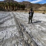
Major Landscape Features in the Mojave Desert
The Mojave is not empty, and it is certainly not all the same. It contains a wide range of landforms and surface types.
Common landforms in the region
mountain ranges
basins
dry lakes
salt flats
canyons
gravel plains
desert washes
volcanic areas
dune fields
Famous landscape anchors
Some of the most important physical reference points include:
Death Valley
Badwater Basin
Panamint Mountains
New York Mountains
Providence Mountains
Piute Range
dry passes and basins
historic travel corridors
These features show that the Mojave is a structured landscape. It is not a blank canvas. It is a terrain system with ridges, depressions, surfaces, and transitions that all matter when reading a map.
Death Valley and Badwater Basin on the Mojave Map
No California map of the Mojave Desert feels complete without Death Valley.
Death Valley is one of the most recognizable geographic anchors in the region. It offers a dramatic reference point that helps readers orient themselves within the larger desert system. It is widely known as the lowest point in North America, and it sits near the transition area between the Mojave and the Great Basin.
Why Death Valley matters on a map
This site is a major geographic landmark.
The location helps define the northern Mojave area.
The area is one of the easiest desert places to identify.
The destination attracts travelers, photographers, and researchers.
The landscape illustrates the dramatic range of desert terrain.
Badwater Basin is another essential anchor. It is famous because it sits at the lowest elevation in the United States. That makes it both a factual highlight and a strong visual landmark for readers trying to understand the desert on a map.
When people look at the Mojave on a map, Death Valley often becomes the headline feature that holds the rest of the region together in their mind.
Flora: Plants That Define the Mojave Desert
The Mojave is not barren. It supports a robust plant community adapted to heat, aridity, and poor soils.
Important Mojave plants
Joshua tree
creosote bush
Mojave yucca
desert Spanish bayonet
shadscale
big sagebrush
bladder-sage
bursages
blackbush
occasional cacti
burroweed
Why Joshua trees matter so much
The Joshua tree is probably the most iconic plant associated with the Mojave Desert. It is more than a symbol. It is also a geographic indicator. When readers see Joshua tree habitat on a map, they are often looking at classic Mojave territory.
Joshua trees help define the ecological identity of the region. They are one of the strongest signals that the map is showing true Mojave habitat rather than a nearby transition zone.
A simple example: a road that passes through dense Joshua tree country, often crossing a genuine high-desert Mojave setting. A road that shifts into different plant communities may be moving into another ecological band. Plant life, then, becomes part of map interpretation.
Fauna: Animals That Live in the Mojave Desert
The Mojave supports a wide range of animals adapted to limited water, intense sun, and long movement distances.
Common Mojave animals
: Desert tortoise
kangaroo rats
sidewinder rattlesnakes
bats
bighorn sheep
coyotes
black-tailed jackrabbits
foxes
rattlesnakes
chukwallas
Why are desert animals important?
These animals prove that the Mojave is a living ecosystem. Even when the land looks sparse, there is a complex biological network operating across the region.
The desert tortoise
The desert tortoise is one of the most important Mojave species. It is widely recognized and closely protected. Visitors need to be careful around it, especially on roads, in preserve areas, and near habitat corridors.
Wildlife also changes how the map should be understood. A good Mojave map is not just a route map or a city map. It is also a habitat map. It helps identify where life exists, where it moves, and where it needs protection.
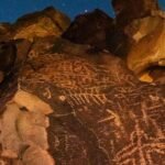
Human History and Cultures in the Mojave
The Mojave Desert has a long human history. It was never an empty place.
Long-term human presence
People have lived in the Mojave for thousands of years. Native communities developed deep knowledge of the land, water sources, seasonal cycles, and travel routes. That knowledge shaped survival and movement in a landscape that many outsiders incorrectly viewed as empty.
Important historical themes
Native trade routes
old trails
water source use
Agricultural areas near rivers
early exploration
mining
railroads
military routes
modern conservation
The Mojave Road
The Mojave Road is a powerful example of how geography and history intersect. It was used for centuries as a Native travel route and later became an important transportation corridor in the 1800s.
This route is a reminder that the Mojave map is not only physical. It is historical. The same terrain that shapes climate and ecology also shapes movement, settlement, trade, and memory.
Why this matters
When you read the Mojave on a map, you are also reading layered human use:
ancient footpaths
trading routes
supply roads
settlement patterns
protected lands
modern highways
That is what makes the region so rich. It is a spatial palimpsest: a place where many human systems have overlapped over time.
The California Desert Protection Act and Public Lands
A major part of the modern Mojave story is public land protection.
Large portions of the desert are managed as:
national parks
national preserves
national monuments
conservation lands
military lands
state and local planning areas
private lands
Why public lands matter
The Mojave is vast, remote, and ecologically fragile. Public land management helps protect:
wildlife habitats
scenic landscapes
cultural sites
travel corridors
fragile soils
dark skies
recreation zones
The California Desert Protection Act played a major role in expanding protections in the region. It helped shape the way the Mojave is managed today and influenced the structure of several protected landscapes.
This matters because the Mojave map is also a land-status map. Some areas are protected, some are open, some are restricted, and some operate under special management rules. Knowing that difference helps visitors, researchers, planners, and conservation-minded readers understand how the desert functions.
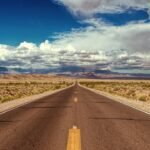
Travel Tips for Visiting the California Mojave Desert
A trip to the Mojave can be extraordinary, but preparation is non-negotiable. The desert rewards careful travelers and punishes careless ones.
Basic travel tips
carry extra water
Check road conditions before you go.
Use official maps
Keep your fuel tank full.
Start early in hot weather.r
Avoid risky summer travel when possible.le
Bring sun protection
Tell someone your route.
Do not depend on weak phone signals
Best time to visit
The most comfortable months are usually:
October
November
December
January
February
March
April
These months are better for hiking, sightseeing, photography, and long-distance driving.
Why official maps matter
In remote desert regions, navigation apps may not show road closures, seasonal access changes, or trail restrictions. That can create real safety issues. Official maps are often more reliable because they reflect land-management updates and current access rules.
Key Places to Visit in the Mojave Desert
The Mojave has many landmarks that work well for road trips, research, photography, and general exploration.
Major travel anchors
Joshua Tree National Park
Death Valley National Park
Mojave National Preserve
Twentynine Palms
Barstow
Needles
Mojave
Lancaster
Victorville
scenic desert highways
historic roads and passes
Why are these places useful
These landmarks help create a route model.
A traveler might use:
Barstow as a starting point
Mojave or Lancaster as western orientation points
Twentynine Palms as a Joshua Tree gateway
Needles as an eastern edge marker
Death Valley as a dramatic northern reference
This is one of the most practical ways to read the California map of the Mojave Desert. Instead of treating it like a vague region, you build an anchor-based route system.
Tourism, Photography, and Outdoor Activities
The Mojave is one of the most rewarding desert regions in the country for outdoor exploration.
Popular activities
hiking
photography
stargazing
road trips
camping
wildlife watching
geology viewing
ghost town exploring
rockhounding
scenic driving
Why photographers love the Mojave
The desert offers:
huge skies
long shadows
dramatic ridges
sunrise and sunset color
unusual rock shapes
iconic Joshua tree views
Why stargazers love it
The Mojave can offer very dark skies, especially in remote areas. That makes it ideal for night-sky viewing and astrophotography.
In semantic terms, the desert is not only a destination. It is an experience space. It provides visual contrast, temporal contrast, and atmospheric clarity that many other regions cannot match.
Environmental Issues and Conservation in the Mojave
The Mojave is beautiful, but fragile.
Main conservation pressures
development
off-road damage
habitat loss
climate stress
energy projects
water scarcity
road fragmentation
Why conservation is necessary
Many desert species and plant communities recover slowly after disturbance. That means even small damage can have long-lasting effects. Desert ecosystems are often resilient in some ways, but they are not invulnerable.
What protection should focus on
wildlife corridors
fragile soils
protected species
cultural sites
responsible recreation
clean travel practices
land-use balance
The Mojave is not only a place to visit. It is also a place to manage carefully. Protection is not a separate issue from travel or mapping; it is part of the same ecosystem logic.
Interesting Facts About the Mojave Desert
Here are some memorable facts that help reinforce the topic.
The Mojave Desert is one of the best-known deserts in the United States.
It is often described as the smallest and driest desert in the U.S.
It extends beyond California into Nevada, Arizona, and Utah.
Death Valley is one of the most famous landmarks in the region.
Badwater Basin is the lowest elevation in the United States.
The Mojave supports a wide variety of plants and animals.
Joshua trees are one of the best indicators of Mojave habitat.
The region includes both protected lands and active-use areas.
Many of its boundaries depend on the type of map being used.
The Mojave is a major travel, conservation, and history region, not just a scenic desert.
Pros and Cons
Pros
Huge scenic variety
Famous landmarks like Death Valley and Joshua Tree
Great photography and stargazing
Rich wildlife and plant life
Strong history and cultural value
Many protected lands and visitor areas
Cons
Extreme heat in summer
Very limited water in remote places
Long distances between services
Rough roads in some areas
Fragile habitat that needs care
Sudden weather shifts in some seasons
This is why planning matters so much in the Mojave. The landscape can be breathtaking, but it also demands respect, preparation, and attention.
How to Understand the Mojave Desert on a California Map
This is the easiest way to build a mental map of the region.
Step 1: Find the southeastern California desert belt
Start with the inland desert area east of Los Angeles and south of the Great Basin edge. This is the broad geographic frame.
Step 2: Look for city anchors
Use places like:
Barstow
Victorville
Hesperia
Lancaster
Mojave
Twentynine Palms
Needles
These cities and towns give the region a recognizable structure.
Step 3: Add the landmark layer
Then place major references such as:
Death Valley
Joshua Tree
Mojave National Preserve
Badwater Basin
These landmarks act like high-value semantic nodes in the map.
Step 4: Check the borders
Notice the mountain ranges and transition zones:
Sierra Nevada
San Gabriel Mountains
San Bernardino Mountains
Tehachapi Mountains
These features explain why the desert begins where it does and why the edges are not perfectly fixed.
Step 5: Remember the map’s purpose
The Mojave can look different depending on whether the map is for:
ecology
travel
county use
air quality
land management
wildlife protection
This is why boundary differences are normal rather than confusing. Different use cases produce different map interpretations.
FAQs
No. It is centered in southeastern California, but it also extends into Nevada, Arizona, and Utah. California contains the most searched and most visible part of the desert.
The best way is to use city anchors, landmark anchors, and border landmarks together. Focus on Barstow, Victorville, Lancaster, Twentynine Palms, Needles, Death Valley, and Joshua Tree.
The Mojave blends into the Great Basin Desert to the north and the Sonoran Desert to the south and southeast. Mountains such as the Sierra Nevada, San Gabriel Mountains, San Bernardino Mountains, and Tehachapi Mountains help shape its edges.
Because elevation matters here. Much of the region sits at higher elevations than low desert areas, which affects climate, vegetation, and temperature swings.
Commonly referenced desert portions include Inyo, Kern, Los Angeles, San Bernardino, Riverside, and Imperial counties.
Important cities include Barstow, Victorville, Hesperia, Lancaster, Mojave, Twentynine Palms, and Needles.
Conclusion
The Mojave Desert is more than a dry stretch of land. A California map reveals its cities, landmarks, borders, and travel routes simply. With the right map, the region becomes easier to understand and explore.