Introduction
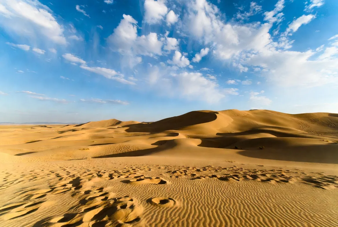
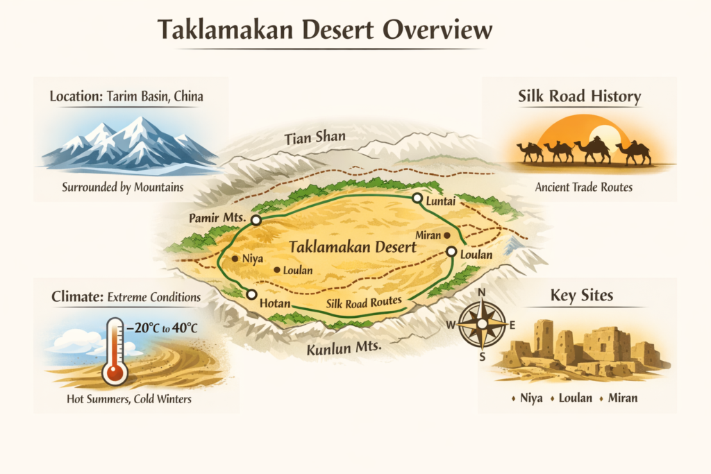
The Taklamakan Desert is one of the largest and most extreme sand deserts in the world, located in the heart of the Tarim Basin in western Xinjiang, China. Surrounded by the towering Tian Shan, Kunlun Mountains, and Pamir Mountains, this vast desert has played a crucial role in the history of the Silk Road. Ancient traders, explorers, and archaeologists have long been fascinated by its shifting dunes, hidden oasis towns, and lost cities buried beneath the sands.
Quick answer — where the Taklamakan sits
The Taklamakan Desert lies in the center of a larger geographic region we call the Tarim Basin. The basin is encircled by high mountain chains that act as a meteorological and hydrological rim: meltwater from these ranges feeds narrow riparian corridors. Historically, merchants and caravans treated the interior as a high-cost token to avoid; instead, as they transited the rim routes, where oasis-node tokens made long-distance trade feasible.
Framing the region in NLP terms: tokens, entities, features, and corpora
Think of the landscape as a corpus and individual geographic items (oases, ruins, roads, mountain passes) as named entities. When preparing content, maps, or a lead magnet, apply common NLP operations to the region:
- Tokenization (spatial tokens): split the region into meaningful units — core sand sea (erg), interdune zones, riverine oases, mountain fans, and engineered corridors (roads and rail). Each token carries attributes (area, elevation, dune height, surface type).
- Named entity recognition (NER): identify cardinal features: cities, archaeological sites, highways, mountain ranges. Store each as an entity with a canonical name, coordinates, and metadata (access restrictions, permit requirements, sensitivity).
- Embeddings (semantic vectors): create vector representations of places and features (e.g., a vector for “Hotan oasis” that captures climate, access, and museum presence). Use these to power similarity search (find sites like Niya or Loulan).
- Temporal features: encode month-of-year, mean daytime range, precipitation probability, and dust-storm frequency as time-series features to build a fieldwork suitability index.
- Ontology & schema: model relationships (e.g., oasis located in the Tarim Basin; ruin near a river; highway connects Hotan and Luntai). This helps assemble a QGIS project or a data README that’s machine- and human-friendly.
- Data artifacts: A0 GeoTIFF, MBTiles, GPX sample routes — treat these as shareable artifacts with metadata (projection EPSG, source, last update) and access control for sensitive archaeological coordinates.
Below, we translate the classic guide sections into that NLP-informed frame while preserving practical, field-ready advice.
Geospatial anatomy: Tarim Basin — location & geometry
Plain description
The basin is a large interior depression in northwest China. It resembles a bowl: mountain ranges form the rim; rivers descend from the rim and terminate in narrow green ribbons — the oases — that punctuate the desert margin. The central sand sea is a broad erg of mobile dunes that shift under persistent wind regimes.
Natural boundary entities
- Kunlun Mountains (southern rim): source of meltwater feeding southern oasis chains and alluvial fans.
- Tian Shan (northern rim): a broad orographic barrier that shapes precipitation and local climate.
- Pamir Mountains (western link): historic transit zone toward Central Asia.
These ranges are hydrological sources: seasonal snowmelt becomes the key feature in oasis-node persistence. In data terms, treat each range as a parent entity that supplies water-flow attributes to dependent oasis entities.
Spatial extent and morphology
- Area: ~320,000–337,000 km² (variable by measurement and criteria). When modeling the area, record the measurement method (satellite-derived dune boundaries vs. administrative outlines).
- Dune forms: erg fields with individual dune crests commonly tens of meters high; some ridges reach 30–90 m.
- Elevation: roughly 800–1,500 m a.s.l. — Add elevation Feature fields to each spatial tile in your DEM.
- Surface mobility: high for interior dunes; lower near irrigated edges and engineered shelterbelts. Use time-series satellite indices (NDVI, albedo) to detect vegetation response to afforestation projects and to flag dune mobility trends.
Landscape features expressed as attributes
- Erg (sand sea): high-mobility surfaces, sparse vegetation; map with grain-size and substrate indicators where possible.
- Interdune flats: often saline or clayey, occasional ephemeral water pooling; flag as potential soft-ground hazard in route planning.
- Alluvial fans: at mountain mouths; many oases and settlements sit here — important logistic nodes with water and services.
- Playas & salt flats: model as low-permeability surfaces; after rain, they can be deceptive and dangerous for vehicles.
- Rivers & oasis corridors: linear features with the highest human activity; add museum points, fuel stations, and lodging as attributes in the MBTiles layer.
Flora & fauna
Vegetation is largely confined to oasis riparian corridors. Populus euphratica (desert poplar) stands are a recurring morphological marker of perennial river flow. Fauna includes small desert mammals (gerbils, jerboas), reptiles, and migratory birds that use oasis corridors. For biodiversity layers in a research bundle, include coarse habitat classification and conservation designations.
Climate & weather patterns — a month-by-month planner
Treat each month as a time slice with features: daytime temperature range, dust-storm probability, water requirement multiplier, and fieldwork-safety index. The table below is designed for planning; convert these into a simple numeric index if you want to filter “safe months” in your UI.
| Month | Typical daytime range | Field notes |
| Jan | −20 °C to −5 °C | Coldest month; severe nighttime lows. Field risk: hypothermia, ice. |
| Feb | −15 °C to 0 °C | Dry, clear; long thermal swings. |
| Mar | −5 °C to 10 °C | Spring wind increases; rising dust-storm frequency. |
| Apr | 0 °C to 18 °C | Windy; plan for dust mitigation and temporary schedule shifts. |
| May | 8 °C to 25 °C | Warm and drier; good prep window for vehicle checks. |
| Jun | 15 °C to 30 °C | Hot; schedule heavy travel early/late in the day. |
| Jul | 20 °C to 40 °C | Peak heat; avoid heavy physical work at midday. |
| Aug | 15 °C to 35 °C | Still hot; nights cooler. |
| Sep | 8 °C to 28 °C | Excellent window — calmer winds, good for archaeology. |
| Oct | 0 °C to 18 °C | Stable conditions, fewer dust days. |
| Nov | −5 °C to 5 °C | Quick temperature transition; pack cold-weather gear. |
| Dec | −20 °C to −5 °C | Severe cold at night again. |
Precipitation: core desert <50–100 mm/year. Mountain margins get more and feed oasis nodes. In a data product, include altitude-based precipitation rasters and a hydrological model that links snowpack to oasis flow reliability.
Major archaeological rim sites — entities, short synopses & sensitivity
For ethical publication and data release, each site is a sensitive entity. Offer generalized waypoints publicly but reserve precise GPS coordinates for accredited researchers under an access agreement.
- Niya — southern rim site. Excavations produced wooden documents, textiles, and domestic remains useful for linguistic and social-history corpora.
- Miran — fort remains and Buddhist murals; important for religious and art-historical vectors.
- Dandan-Oilik — compact ruin cluster with preserved structural elements; valuable for local trade networks.
- Loulan — “lost city” on vanished river channels; a cautionary example of hydrological shifts.
- Gaochang — eastern rim urban center with walls and urban stratigraphy; excellent for urban-archaeology case studies.
A short note on a key explorer: Aurel Stein — his early 20th-century expeditions were formative in discovering ruins and manuscripts. Modern scholarship re-evaluates his finds with updated dating and provenance methods. When building your bibliography/EEAT links, include both Stein’s primary accounts and recent journal re-analyses.
Ethics reminder: never publish precise ruin coordinates in a public overview pack. Provide generalized locality polygons and a transparent process for accredited access.
How to reach the Taklamakan — routes, highways, rail & permit features
Model travel as a graph: nodes = rim towns and fuel/maintenance stations; edges = roads, rail links, and established expedition routes. Annotate edges with travel time distributions, seasonal closure flags, and surface type.
Main rim towns to use as bases
- Hotan — classic southern base with museums and logistic support.
- Kashgar — a major regional hub, cultural resources, and permits assistance.
- Luntai (Bügür) — northern rim service node.
Transport corridors & what to expect
- Tarim Desert Highway — an engineered corridor connecting Hotan to Luntai through the desert. It’s flanked by shelterbelts and service stations; treat it as a high-reliability edge in your travel graph.
- Rail links: Recent rail projects increase rim accessibility; add them as alternative edges in logistics planning with capacity and haul restrictions.
- Permits: model permit requirements as access-control tokens attached to specific nodes and edges (especially for foreigners or for research near sensitive sites). Always verify with local authorities, and list required documents in your README.
Access annotation: in your MBTiles, include a boolean requires_permit and a textual permit_notes field for relevant POIs and polygons.
Practical field kit & survival tips
Build a printable checklist and encode logistical constraints as fields in your GPX/MBTiles layers (e.g., fuel range, nearest hospital, satellite coordination).
Essentials
- Vehicle: high-clearance 4×4, dual tanks, spare tyres, winch, recovery equipment (attach a vehicle_capability attribute to each route).
- Navigation: printed A0 GeoTIFF (300 dpi), MBTiles offline basemap for tablets, GPS device plus GPX backups.
- Water planning: 6–8 L/person/day in hot months,s minimum; for route planning, include a water_cache layer with coordinates and reliability scores.
- Communications: satellite phone or PLB. Add the comms_expectation attribute to each map tile (cellular coverage likelihood).
- Medical: heat-stroke kit, frost-protection gear, wound-care items.
- Permissions & docs: permit copies, local contact list, institutional accreditation if necessary.
- Field technique flags: travel with two vehicles for remote crossings; early-morning egress to avoid midday heat; avoid ephemeral playas when wet; anchor caches near known landmarks and mark clearly.
Field techniques as standard operating procedures
- Convoy minimum = 2 vehicles for remote travel. Annotate convoy route plans in GPX with recommended_convoy_size.
- Move during cool hours and plan midday rest windows; encode recommended travel windows into route metadata.
The map pack: design, gating strategy & ethical controls
Treat the map pack as a digital product with layered access control and metadata.
Free basic pack
- A0 printable GeoTIFF overview (300 dpi) — general coastline and rim features.
- MBTiles offline basemap with contour overlay for tablets (coarse resolution).
- GPX sample routes to major oases and rim towns (generalized; not precise ruin coordinates).
- Short README with licensing and safe-use notes.
Paid research bundle
- High-resolution DEM tiles and 1:50k vector contours.
- GeoTIFF mosaic (EPSG:4326) with river and archaeological waypoint layers — generalized publicly; exact sensitive coordinates only released under signed agreements.
- QGIS project file, print-ready A0 cut-lines, and metadata (sources, acquisition dates).
- Guidance on citing and how to obtain permits: include an institutional vetting workflow in the README.
Ethical release controls:
- Public artifact = CC-BY for overview maps.
- Sensitive site layer = restricted license; access via request form with institutional email and preservation agreement.
- Add last_updated and source_list metadata fields to every file.
README content
- Map projection, scale, and EPSG.
- Data sources & update date.
- Licensing & attribution.
- Emergency coordinates for nearest hospitals and consulates (generalized).
- How to load MBTiles into common mapping apps (step list).
- How to cite the dataset.
Example route table
Design route objects with fields: name, time_estimate, key_stops, notes, fuel_required, water_required.
| Route | Time | Key stops | Notes |
| Tarim Desert Highway rim run | Same-day between rim towns | Hotan — mid-shelter — Luntai | Fast, serviced, and use maintenance stations |
| Guided multi-day expedition | 2–7 days | Oasis chain, ruins, camp sites | Permits & guide required |
| Unsupported crossing | Several days | Variable | High risk; not recommended |
When publishing GPX, validate coordinate accuracy, include a confidence field, and explicitly flag unsupported crossings as not_recommended.
Tourism — common activities & tips
Common activities: museum visits in Hotan and Kashgar, short desert excursions on dunes, camel treks on rim edges, and overland caravan-route tours along the Tarim Desert Highway.
Visitor risk modeling: single-person deep-crossing = high probability of emergency; add a risk_score to tour itineraries and require insurance. Encourage travel with vetted tour operators.
Practical tips: hire local guides for permit navigation and cultural context; always carry printed permits; prioritize evacuation insurance.
Environmental issues & conservation
Model conservation as constrained optimization: maximize infrastructure resilience (shelterbelts, roads) while minimizing water extraction from oasis aquifers.
- Afforestation vs water use: Shelterbelts along highways reduce sand influx but require irrigation that may alter oasis hydrology. When modeling sustainability, include water-budget calculations at the basin scale.
- Heritage protection: looting and unauthorized digs threaten archaeology. Offer a preservation layer and protocols for reporting finds.
- Climate variability: reduced mountain snowpack reduces baseflow; add hydrological stress indicators to your data product and alert subscribers if long-term trends exceed thresholds.
Conservation suggestions for publishers:
- Share generalized coordinates publicly; reserve precise coordinates for accredited institutions.
- Partner with local custodians and museums for monitoring programs and community-led protection.
FAQs
A1: Historically, traders favored rim routes and generally avoided direct central crossings. In contemporary practice, crossings are possible on engineered corridors like the Tarim Desert Highway or by specially supported expeditions. Unsupported crossing is high risk and not recommended. If you are planning a crossing, model the route in GPX, ensure convoy redundancy, and acquire all local permits.
A2: September–October is the preferred window for fieldwork and visits — cooler temperatures and calmer winds reduce dust-risk. Late spring (May) is a secondary window but carries a higher dust probability. Avoid mid-summer months for strenuous fieldwork because of heat exposure.
A3: Some rim sites and museums are visitor-accessible. Many excavation sites remain restricted and require permits, institutional affiliation, or guided visits. Always check with local authorities and museum curators before planning site visits.
A4: Offer a gated A0/GeoTIFF/MBTiles/GPX pack on your site: provide a free overview pack for email capture and a paid research bundle for institutions. Ensure the README documents licensing and access restrictions for sensitive archaeological data.
Conclusion
The Taklamakan Desert is a land of extremes where least-cost human networks hugged the rim, and conservation concerns intersect with modern infrastructure. For researchers and overlanders, the oases and rim towns hold the essential access, archives, and living cultural links to the Silk Road. As a publisher, build an ethical, data-rich pillar: clear maps, safe travel SOPs, and a gated A0/GeoTIFF/MBTiles/GPX bundle that helps real users plan safe, legal research while protecting fragile heritage.


