Introduction
When people search for desert states in the US, they usually want a simple answer: which states have deserts and what makes them different? The answer is more Interesting than a short list. U.S. deserts vary by climate, elevation, and landscape, so some are hot, some are cold, and all are shaped by low rainfall and scarce water. This guide covers the main desert states, the major desert systems, and the key features that make each one unique.
Quick Answer: Which States Have Deserts?
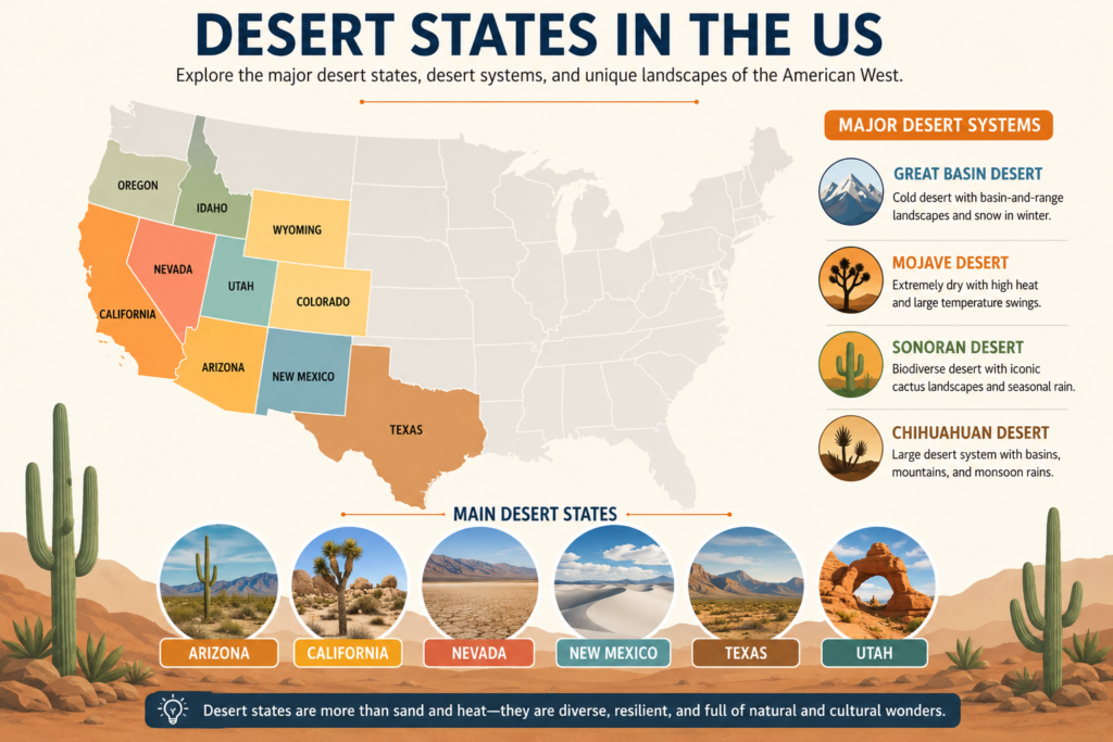
The clearest short answer is this: the main desert states in the US are Arizona, California, Nevada, New Mexico, Texas, and Utah.
That is the core answer most readers are looking for when they search for desert states. But the full picture is wider and more nuanced. Depending on the map, source, or geographic framework, you may also see Colorado, Idaho, Oregon, and Wyoming included because they contain desert, semi-desert, or high-desert areas.
So the best way to think about desert states is this:
A state may be strongly associated with desert landscapes, even if it is not entirely desert.
A state may contain only a smaller desert or high-desert region.
No U.S. state is completely desert from border to border.
Desert terrain often coexists with mountains, forests, grasslands, river valleys, and volcanic zones.
This is why a state-by-state guide is far more useful than a simple yes-or-no list.
What Makes a Place a Desert?
A desert is not defined by dunes alone. It is defined by aridity, or more simply, by very low moisture availability. The essential idea is that a desert receives too little precipitation to support dense vegetation, as a forest or grassland does. That lack of water shapes everything: soil formation, plant survival, animal behavior, human settlement, and even the visual character of the land.
Deserts can be hot or cold. They can be covered in gravel, stone, salt, scrub, or sand. They can rise into mountains or sink into basins. They can be vast and open or broken into rugged valleys. What they all share is the same environmental logic: water is limited, evaporation is often strong, and survival requires adaptation.
This matters because the desert states in the US do not all behave the same way. Their deserts differ based on elevation, latitude, rainfall patterns, nearby mountain ranges, and seasonal storms. As a result, the desert experience in Arizona is not identical to the desert experience in Nevada, and neither is it the same as the desert environment in West Texas or eastern Oregon.
A desert is therefore not a dead space. It is a highly responsive ecological system where every drop of water matters.
Major U.S. Desert Systems at a Glance
The United States is most often discussed through four major desert systems: the Great Basin Desert, the Mojave Desert, the Sonoran Desert, and the Chihuahuan Desert. Each one crosses state lines in different ways, and each one has its own distinct climate signature.
| Desert System | Main States | Main Traits |
| Great Basin | Nevada, Utah, Idaho, Oregon, Wyoming, California | Cold desert, snow in winter, rain shadow effect, basin-and-range terrain |
| Mojave | Southern Nevada, southeastern California, parts of Utah,h and Arizona | Extremely dry, high heat, large temperature swings, sparse vegetation |
| Sonoran | Arizona and California in the U.S. | Very biodiverse, distinctive cactus landscapes and rainfall in multiple seasons |
| Chihuahuan | New Mexico and Texas in the U.S. | Large desert system, basin-and-range geography, monsoon-influenced rainfall |
This table shows why the phrase desert states in the US is more complex than it sounds. The same country contains cold desert basins, hot lowland deserts, biologically rich cactus regions, and high plateau desert systems.
State-by-State Guide to Desert States in the US
Arizona
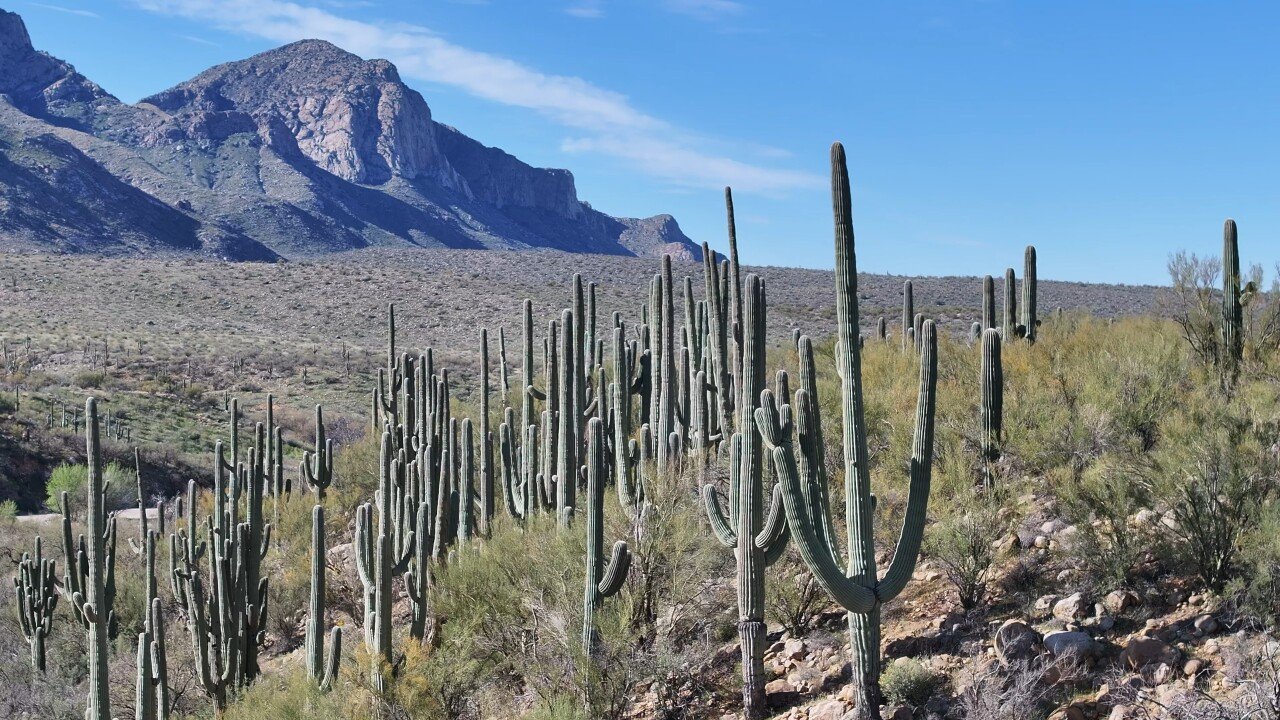
Arizona is one of the most famous desert states in the US and is often the state people picture first when they think of desert landscapes. That Reputation is strongly tied to the Sonoran Desert, one of the best-known desert ecosystems in North America.
Arizona’s desert character is shaped by hot lowlands, mountain ranges, dry valleys, canyon country, and seasonal weather systems that can bring powerful monsoon storms. The state is especially known for iconic desert plants such as the saguaro cactus, ocotillo, and creosote bush. These are not just scenic plants. They are survival specialists, adapted to intense sun, water scarcity, and long dry periods.
The southern part of Arizona is especially desert-rich, but the state is not uniform. It includes elevation changes, rocky slopes, riparian zones, and mountain ecosystems as well. That variety is one reason Arizona is so important in desert geography. It proves that a desert state can be ecologically layered rather than visually repetitive.
Arizona is also a strong example of desert biodiversity. The Sonoran Desert is widely known for its rich mix of reptiles, birds, mammals, and flowering plants. In that sense, Arizona is not a symbol of emptiness. It is a symbol of resilience, adaptation, and environmental variety.
California
California is another major name in the list of desert states in the US, even though many people think first of its coast, mountains, and cities. Southern California contains parts of the Mojave Desert and the Colorado Desert, the latter being part of the broader Sonoran system.
California’s desert regions include places such as Joshua Tree, Death Valley, dry mountain passes, salt flats, rocky basins, and wide open valleys. These landscapes look very different from the state’s beaches, redwood forests, or fertile Central Valley. That contrast is part of what makes California such a powerful example of geographic diversity.
The California desert is famous for dramatic temperature extremes, broad empty horizons, unusual rock formations, and rare desert plants. It is also a major destination for hiking, camping, photography, stargazing, and landscape tourism. For many visitors, California’s desert is not just a climate zone. It is a visual experience, an outdoor laboratory, and a place where geology is visible in dramatic form.
California shows that a single state can hold many environmental identities at once. Desert, coast, mountains, and valley all coexist in one large geographic system.
Nevada
Nevada is often considered the most desert-shaped state in the country. It sits at the center of the Great Basin Desert, which is the largest desert region in the United States by area. Large parts of Nevada are dry, elevated, and organized by the basin-and-range pattern that defines much of the interior West.
Nevada’s landscapes include long basins, parallel mountain ranges, dry lake beds, sagebrush valleys, and internal drainage systems where water does not reach the sea. That internal drainage is a defining feature of many Great Basin landscapes. Rain and meltwater may collect in a basin, evaporate, sink into the ground, or leave behind salt and mineral deposits.
Nevada is also a good example of why the phrase desert states in the US can be misleading if it makes people assume all deserts are hot. The Great Basin is a cold desert, which means it is dry but also capable of producing snowy winters and very cold nights. Summers can still be hot, but the seasonal contrast is much stronger than in many lowland desert areas.
Geologically, Nevada is an excellent showcase of how mountain uplift, faulting, erosion, and arid climate interact to form a desert landscape over time. Its terrain is dramatic, spacious, and deeply informative for anyone interested in physical geography.
New Mexico
New Mexico is one of the most interesting desert states in the US because it contains more than one kind of dry landscape. It is strongly associated with the Chihuahuan Desert in the south and southeast, but it also includes high-desert plateaus, mountain zones, and other dry regional environments.
New Mexico’s desert terrain may include basins, mesas, dunes, volcanic fields, dry grasslands, and canyon country. This makes the state especially valuable for readers who want to understand that “desert” is not a single look or a single climate type. New Mexico shows a transition zone where different land systems overlap.
The state is also rich in cultural history. Indigenous traditions, Spanish colonial history, frontier settlement, ranching, mining, and modern artistic communities all contribute to the identity of the region. In New Mexico, the desert is not just a physical environment. It is also a cultural landscape with layers of memory, meaning, and continuity.
That human depth makes New Mexico a crucial part of any discussion of desert states in the US. It reminds us that deserts are inhabited places with long histories, not vacant zones waiting to be explored.
Texas
Texas is one of the major desert states in the US, especially because of its western region. West Texas contains substantial portions of the Chihuahuan Desert, which extends far into northern Mexico and represents one of the largest and most important desert systems in North America.
The Texas desert includes wide basins, mountain ranges, desert grasslands, dry river valleys, isolated peaks, and rugged plateaus. Big Bend is one of the best-known examples. It combines river corridors, mountain scenery, and desert landscapes in a single national park, showing how desert environments can be far more varied than the stereotype suggests.
Texas is a strong reminder that desert geography often appears in a specific region of a large state rather than across the entire state. Texas has many climates and landscapes, but its western desert zone is significant enough to place it firmly within the broader desert-state conversation.
The Chihuahuan influence in Texas also matters ecologically. The region supports unique plant communities, wildlife species, and seasonal rainfall patterns that distinguish it from other desert systems.
Utah
Utah is another essential desert state and one of the most visually striking. It includes parts of the Great Basin Desert as well as other dry regions shaped by elevation, rain shadows, and basin-and-range landforms.
Utah’s desert landscapes are often defined by red rock cliffs, canyons, arches, salt flats, dry plateaus, and dramatic transitions between high desert and mountain terrain. This gives Utah a particularly iconic visual identity. Many of its most famous landscapes look like natural sculpture, with layered sandstone, sweeping erosion patterns, and wide open space.
Utah is important because it demonstrates that desert states are not always hot, flat, or sandy. High elevation can create cooler, windier, and more rugged desert conditions. That variety is part of what makes Utah such a valuable example in physical geography and travel content alike.
Colorado
Colorado is not usually one of the first states people think of when discussing deserts, but some parts of the state do contain desert-like or high-desert landscapes. That is why Colorado appears in broader geographic treatments of the desert states in the US.
The desert-related regions of Colorado are typically linked to dry basins, plateaus, semi-arid zones, and transitional landscapes that connect to larger desert systems in the Southwest. Colorado is therefore less of a core desert state and more of a borderland state where dryland geography becomes more complex.
This makes Colorado useful for understanding the gray areas in desert mapping. Not all desert regions fit neat public labels. Some exist as partial zones, transition zones, or ecological overlaps.
Idaho
Idaho includes dry lands in its southern and southwestern regions, and some geographic frameworks connect those areas to the Great Basin or high-desert systems. Because of that, Idaho sometimes appears in broader discussions of desert states in the US.
Idaho’s dry lands may include sagebrush country, basins, volcanic terrain, and open steppe-like spaces. These landscapes are not what most people think of first when they hear “desert,” but they still belong to the broader dryland continuum.
Idaho is a good reminder that desert geography is often a matter of degree, not just category. A state can hold desert-adjacent terrain without being widely recognized as a classic desert state.
Oregon
Oregon surprises many readers in this context, but parts of eastern Oregon are dry enough to be included in discussions of desert or high-desert regions. For that reason, Oregon can appear in a broader mapping of the desert states in the US.
Eastern Oregon features dry plateaus, sagebrush plains, basin landscapes, and arid to semi-arid conditions. Most of Oregon is not desert at all, but its eastern side shows how quickly climate and landform can change across a large state.
Oregon is useful in a search-intent sense because it broadens the concept of desert beyond the most obvious Southwest examples. It helps users understand that dryland geography exists in more states than the popular imagination usually assumes.
Wyoming
Wyoming is also included in some larger desert-region maps because parts of the state are dry, open, elevated, and semi-arid. It may not be the first state people mention when thinking about the desert, but its landscapes are still relevant to the broader geographic picture.
Wyoming shows the boundary condition between desert, steppe, and high plains environments. These areas can have sparse vegetation, limited rainfall, and wide open terrain that resembles desert systems in some respects.
In broader SEO and geographic terms, Wyoming is useful because it demonstrates that desert-like conditions are not confined to a small cluster of famous states. They spread across a much larger western interior.
The Four Major Desert Systems in Detail
1. The Great Basin Desert
The Great Basin Desert is one of the most important desert regions in the United States. It is a cold desert, which means that while it is dry, it also experiences cold winters, snowfall, and sharp seasonal contrast.
This desert is shaped by the rain shadow effect, high elevation, mountain ranges, and internal drainage. Moist air moving inland loses much of its water over the western mountains before it can reach the basin interior. As a result, the landscape on the leeward side becomes significantly drier.
The Great Basin is not the stereotypical desert with endless dunes. Instead, it is a layered landscape of basins, ridges, salt flats, dry lakes, sagebrush, rocky hills, and alpine mountains. Because the elevation changes are so dramatic, the Great Basin can support both desert and mountain ecological communities.
This desert system is important because it changes the way people think about arid landscapes. A desert does not have to be hot all year. It can be cold, snowy, and still deeply desert-like.
2. The Mojave Desert
The Mojave Desert is one of the driest and most iconic desert regions in North America. It is famous for intense heat, sparse vegetation, rugged mountains, and wide open basins. It is often considered one of the most recognizable desert environments in the world.
The Mojave is known for Joshua trees, cracked earth, dry basins, thermal extremes, and large day-night temperature differences. Some areas receive very little precipitation, and plant life must be highly specialized to survive the intense stress of drought and heat.
Despite its harshness, the Mojave is not lifeless. It supports a distinctive ecological community with plants and animals uniquely adapted to water scarcity. The visual identity of the Mojave also makes it a magnet for travelers, photographers, and filmmakers.
The Mojave helps explain why desert states in the US are often linked with powerful imagery. This is not just climate. It is landscape branding, ecological adaptation, and cultural symbolism all at once.
3. The Sonoran Desert
The Sonoran Desert is one of the most biologically rich deserts in North America. It is sometimes described as a desert of abundance because it supports a remarkable number of plant and animal species compared with many other desert systems.
One of the Sonoran Desert’s most famous features is its cactus landscape, especially the towering saguaro. But the Sonoran is much more than cactus scenery. It includes shrubs, trees, grasses, wildlife corridors, seasonal bloom cycles, and river-linked habitats that make it one of the most diverse dry ecosystems on the continent.
The Sonoran is especially important in Arizona and parts of California, and it extends south into Mexico. Its rainfall pattern is also distinctive because many areas receive moisture in more than one season. That extra water helps create greater biological variety than in more extreme deserts.
For readers and search engines alike, the Sonoran is central to the meaning of desert states in the US because it shows that desert does not equal barren. Some deserts are among the most ecologically active landscapes in North America.
4. The Chihuahuan Desert
The Chihuahuan Desert is the largest in North America. It spans large portions of New Mexico and Texas in the United States and continues deep into Mexico. It is a major desert system both geographically and ecologically.
This desert is known for basin-and-range landforms, hot summers, cool or cold winters, summer monsoon rainfall, playas, dune fields, and broad dry basins. It supports a striking range of plants and animals and is considered one of the most diverse desert ecosystems in the world.
At the same time, the Chihuahuan is under pressure from water use, overgrazing, invasive species, development, and changing land-use patterns. That makes it important not only as a geographic feature but also as a conservation priority.
The Chihuahuan Desert is one of the strongest reasons the topic of desert states in the US deserves a deep article. It links ecology, hydrology, land management, culture, and climate change in one region.
Geography: Why Desert States Exist Where They Do
The deserts in the United States are concentrated largely in the West and Southwest because of the way climate, geography, and atmospheric circulation interact. Desert formation is not random. It follows physical laws and regional patterns.
Rain Shadow Effect
One of the most important causes of desert formation is the rain shadow effect. When moist air moves inland, it is forced upward by mountain ranges. As it rises, the air cools, and moisture condenses and falls on the windward side. By the time the air crosses the mountain and descends on the leeward side, it is much drier.
This process helps create arid inland regions such as the Great Basin. It is one of the fundamental mechanisms behind several Western deserts.
High Elevation
Elevation plays a major role, too. Highland can be dry without being hot all the time. That is why some desert regions are cold in winter and still classified as deserts. The Great Basin is the most famous example of this pattern.
Internal Drainage
In some desert regions, rivers and streams do not flow to the ocean. Instead, water ends in basins where it evaporates, sinks underground, or accumulates as salt flats and dry lake beds. This is known as internal drainage, and it is common in the Great Basin and parts of the Chihuahuan system.
Seasonal Rain Patterns
Different deserts receive rainfall in different ways. Some get winter precipitation. Some receive summer monsoon moisture. Some are so dry that even small changes in rain strongly affect vegetation and wildlife. This is one reason desert states are not interchangeable. They may all be dry, but their hydrological rhythms are distinct.
Climate and Weather Patterns
The climate of the desert states in the US varies significantly by region, elevation, and season. The word “desert” tells us that water is limited, but it does not tell us everything about temperature or weather timing.
Great Basin Climate
The Great Basin has hot, dry summers and cold, snowy winters. It is a desert, but not a tropical one. Its seasonal contrast is one of its defining characteristics, and it is one reason the region supports both desert shrubs and mountain ecosystems.
Mojave Climate
The Mojave is exceptionally dry and often very hot during summer. Some areas receive very little annual precipitation. Temperature swings between day and night can be dramatic, which adds to the environmental stress on both plants and animals.
Sonoran Climate
The Sonoran often receives rainfall in multiple seasons. This seasonal variety contributes to its exceptional biodiversity. The presence of both winter and summer moisture in some places creates a more productive ecological environment than many other deserts.
Chihuahuan Climate
The Chihuahuan Desert commonly experiences summer monsoon rains and cooler winters. Its rainfall rhythm shapes the types of vegetation that grow there and supports a mix of shrubs, grasses, and cacti.
Weather Hazards
Desert weather can also be dangerous. Common hazards include extreme heat, dehydration, sun exposure, flash floods, dust storms, and cold nights in higher elevations. A desert may appear calm and timeless, but weather conditions can shift quickly and harshly.
That is why travelers in desert regions need to plan carefully. The climate is beautiful, but it demands respect.
Landforms in Desert States
One of the most visually striking aspects of desert states in the US is the variety of landforms. These landscapes are shaped by wind, water, faulting, erosion, and long geological time.
Sand Dunes
Dunes are one of the most famous desert features, but they do not define every desert. Some desert systems have little visible sand at all. Still, dune fields can create memorable and dramatic scenery.
Salt Flats and Dry Lakes
Many desert basins contain dry lake beds or old playa systems. When water disappears, minerals remain behind. Over time, these areas can become bright salt flats or cracked surfaces that look almost lunar.
Mesas and Plateaus
Flat-topped landforms are common in the desert Southwest. They appear prominently in Utah, New Mexico, Arizona, and nearby regions. These elevated surfaces often stand out against surrounding valleys and basins.
Canyons and Cliffs
Long-term erosion by water has carved deep canyons and cliff walls throughout many desert states. Even in very dry climates, occasional flooding and runoff can reshape the land powerfully.
Rocky Basins and Mountain Ranges
Many desert regions are defined by a basin-and-range pattern, where broad lowlands alternate with mountain chains. This pattern is especially visible in Nevada, Utah, New Mexico, and parts of California.
Volcanic Terrain
Some desert areas also contain lava fields, volcanic cones, dark rock surfaces, and ancient flows. These features show that desert landscapes are often geologically active and historically complex.
The important takeaway is simple: desert land is not dull. It is one of the most dynamic and visually expressive environments in the United States.
Plants That Define Desert States
Desert plants survive through remarkable biological strategies. They may store water in thick stems, reduce leaf loss, grow deep roots, bloom rapidly after rain, or use other adaptations to conserve moisture.
Common desert plants include:
saguaro cactus
Joshua tree
ocotillo
creosote bush
yucca
sagebrush
desert wildflowers
bristlecone pine in high desert settings
Sonoran Desert Plants
The Sonoran is especially famous for cactus diversity. The saguaro is the classic emblem, but the region also supports many shrubs, flowering plants, and smaller desert species that thrive through seasonal rainfall.
Chihuahuan Desert Plants
The Chihuahuan is one of the most plant-diverse deserts on Earth. It supports a wide array of cactus species, shrubs, grasses, and drought-adapted plants that respond to its monsoon-influenced climate.
Great Basin Plants
The Great Basin is known especially for sagebrush and dry shrub communities. In higher elevations, however, the vegetation shifts toward forests and alpine plants, showing the complexity of the region.
Mojave Plants
The Mojave is much drier than many other desert systems, so its vegetation is more scattered and often more specialized. Plant life there tends to be adapted to severe heat, limited moisture, and long dry intervals.
Plants are central to the story of the desert states in the US because they reveal how life persists under stress. They also give each desert system its own visual identity.
Animals Found in Desert States
Desert states support far more wildlife than many people assume. Animals survive by staying active at night, burrowing underground, reducing water loss, using shaded habitats, or evolving specialized physiologies.
Common desert animals include:
desert tortoise
Gila monster
kangaroo rat
bighorn sheep
pronghorn
desert iguana
roadrunner
coyote
kit fox
bats
snakes and lizards
hawks and owls
Sonoran Wildlife
The Sonoran stands out for its biodiversity. It supports a wide mix of mammals, reptiles, birds, amphibians, and even fish in riparian zones and seasonal waters.
Chihuahuan Wildlife
The Chihuahuan is also highly diverse and supports many unique desert-adapted species. Its combination of dry basins, mountain zones, and seasonal rainfall creates rich habitat variation.
Great Basin Wildlife
The Great Basin includes a mix of desert and mountain species because of its elevation range. Wildlife here often shifts dramatically between low basins and higher slopes.
Mojave Wildlife
The Mojave’s animals are adapted to intense dryness and heat. Many are nocturnal, burrowing, or extremely efficient at conserving water.
The presence of such a wide range of wildlife reinforces a crucial point: desert states are not empty. They are active ecosystems with food webs, seasonal rhythms, and survival strategies.
Human History and Culture in Desert States
Desert landscapes are deeply tied to human history. Indigenous peoples lived in these regions for thousands of years and developed sophisticated ways of life based on local plants, animals, seasonal movement, and water management.
In the Southwest, desert culture includes Indigenous heritage, Spanish colonial influence, frontier expansion, ranching, mining, and the growth of modern cities and tourism centers. These layers make desert states culturally rich as well as geographically fascinating.
Indigenous Connections
Many Native communities continue to maintain deep cultural, spiritual, and practical ties to the desert land. These ties are not historical relics. They are living relationships with place, water, plants, animals, and sacred sites.
Archaeological and Historical Sites
Desert states contain rock art, petroglyphs, ancient paths, settlement remains, and archaeological landscapes that document long human adaptation to harsh conditions. These places are essential for understanding the past.
Modern Culture
Today, desert states are known not only for history but also for art, architecture, astronomy, outdoor recreation, cuisine, tourism, and environmental stewardship. Desert culture is both ancient and modern, rooted in place and continually evolving.
This human dimension makes desert states in the US more than an environmental topic. It is also a story about identity, survival, and continuity.
Tourism in Desert States
Tourism is one of the main reasons people search for desert states. Desert parks and preserves offer iconic scenery, outdoor adventure, and a chance to experience some of the most memorable landscapes in the country.
Popular desert tourism activities include hiking, camping, stargazing, photography, birdwatching, scenic driving, climbing, and visiting national parks and preserves.
Popular Desert Destinations
Some of the most famous desert destinations include:
Joshua Tree
Death Valley
Big Bend
Great Basin National Park
Mojave National Preserve
Saguaro National Park
White Sands
Each destination offers a different kind of desert experience. Some are about vast openness. Some are about dramatic rock formations. Some are about cactus forests. Some are about quiet, reflective solitude.
Best Time to Visit
In many desert areas, the best time to visit is during the cooler months. Summer can be extremely dangerous because of the heat and dehydration risk.
Travel Tips
Travelers should carry enough water, avoid peak heat, protect themselves from the sun, monitor road and weather conditions, plan fuel stops carefully, and share their route with someone if they are entering remote terrain.
Desert travel can be extraordinary, but only when approached with preparation and respect.
Pros and Cons
Pros
Unique scenery
Rich wildlife
Deep cultural heritage
Strong tourism potential
High scientific and educational value
Cons
Extreme heat in many regions
Water scarcity
Flash flood danger
Fragile ecosystems
Long distances between services in remote areas
This balance helps readers understand that desert states are both beautiful and challenging. Their value is real, but so are their limits.
Environmental Issues and Conservation
Desert ecosystems in the United States face growing pressure. Because they recover slowly, even minor disturbances can create long-lasting damage. That makes conservation especially important.
Main threats include water depletion, invasive species, overgrazing, urban growth, road construction, mining, and climate stress.
The Chihuahuan Desert is especially vulnerable, and the Mojave Desert also faces serious pressure from land use change and invasive plants. The future of these ecosystems depends on careful land management and water planning.
Conservation matters because desert states protect rare species, fragile soils, cultural heritage sites, scenic vistas, and water-sensitive ecological systems. Protecting them is not only an environmental issue. It is also a matter of historical preservation, tourism sustainability, and long-term regional resilience.
Interesting Facts About Desert States in the US
The Great Basin is the only cold desert in the United States.
The Mojave is one of the driest major desert regions in North America.
The Sonoran is one of the most biodiverse deserts in the world.
The Chihuahuan Desert is the largest in North America.
Desert states contain mountains, canyons, salt flats, and forests, not just sand.
Many desert plants and animals are nocturnal or most active at night to avoid the heat.
These facts add memorable detail and help the article stand out with stronger informational depth.
Why Desert States Matter
The desert states in the US matter for many reasons. They are important for geography, ecology, history, tourism, science, and conservation. They help us understand how climate shapes landscapes, how organisms adapt to water scarcity, how human communities build cultures in demanding environments, and how fragile ecosystems require thoughtful protection.
They also help us appreciate the American West in a more accurate way. Instead of seeing it as a barren zone, we begin to see it as a mosaic of ecosystems, elevations, and histories. Desert regions are not simple. They are intelligent landscapes in the sense that they have clear environmental logic and deeply interconnected life systems.
When people ask, “Which states have deserts?” they are really asking a much larger question about land, life, and survival. That is what makes the topic so powerful.
FAQs
No. Deserts are defined by dryness, not temperature. The Great Basin is a cold desert, and it can receive snow in winter.
No. Most desert states include many different landscapes such as mountains, forests, grasslands, river valleys, and high plateaus.
The Chihuahuan Desert is the largest in North America.
The Sonoran Desert is widely recognized as one of the most biologically diverse deserts in North America.
They protect rare ecosystems, support wildlife, preserve cultural history, and attract millions of visitors.
Conclusion
The main desert states in the US are Arizona, California, Nevada, New Mexico, Texas, and Utah, with some broader maps also including Colorado, Idaho, Oregon, and Wyoming. Together, they contain the Great Basin, Mojave, Sonoran, and Chihuahuan deserts—each with its own climate, landforms, wildlife, and history. Desert states are not empty or uniform; they are rich, varied landscapes that deserve careful Understanding and protection.


