Introduction
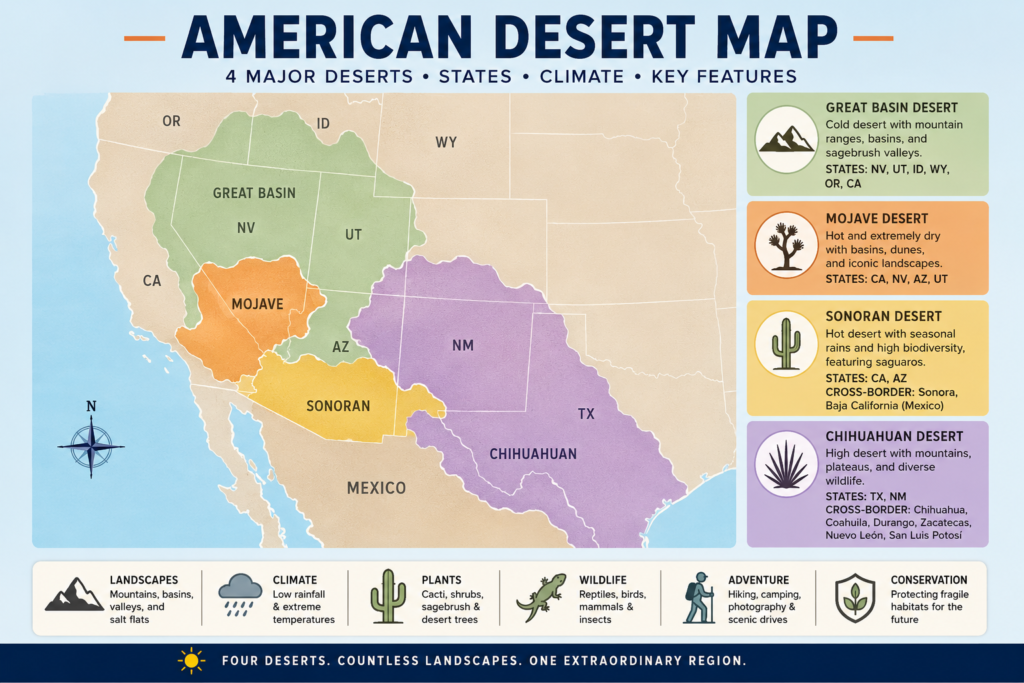
The American Desert Map shows more than dry land. It reveals four major desert regions—the Great Basin, Mojave, Sonoran, and Chihuahuan—each shaped by climate, elevation, and geography. Some deserts are hot, some are cold, and some stretch across multiple states and even international borders. Understanding this map makes it easier to see how landforms, weather, wildlife, and human activity connect across the western United States and northern Mexico.
Overview: What the American Desert Map Really Shows
The phrase America Desert Map usually refers to the major desert regions in the western United States and northern Mexico. In the most widely used educational and park-service framework, there are four major North American deserts:
- Great Basin Desert
- Mojave Desert
- Sonoran Desert
- Chihuahuan Desert
Each of these deserts has a distinct environmental signature. Particularly hot and arid. Some are high-elevation and cold. Some span both the United States and Mexico. Certain areas are famous for extreme temperatures, while others are known for biodiversity, seasonal rains, and dramatic scenery.
A useful desert map should show:
- The states each desert touches
- The boundaries and transitional zones
- The climate and rainfall patterns
- The landforms inside each desert
- The wildlife and plant communities
- The travel value and conservation importance
That is why the topic matters. A desert map is not only a school resource. It is also useful for travel planning, climate literacy, ecological learning, land management, and regional awareness.
A Quick Comparison of the Four Major Deserts
| Desert | Main U.S. States | Cross-Border Area | Climate Snapshot | Map Features to Notice |
| Great Basin | Nevada, Utah, Idaho, Wyoming, Oregon, California | None | Cold desert; much precipitation falls as snow; many areas receive less than 10 inches of rain annually | Mountain ranges, basins, dry valleys, sagebrush, salt flats |
| Mojave | California, Nevada, Arizona, Utah | None | Hot desert; extremely dry; intense summer heat | Death Valley, Joshua Tree region, rain shadows, dry basins |
| Sonoran | California, Arizona | Sonora, Baja California | Hot desert with seasonal rainfall and two rainy periods in many locations | Saguaro country, monsoon bursts, high biodiversity |
| Chihuahuan | Texas, New Mexico | Chihuahua, Coahuila, Durango, Zacatecas, Nuevo León, San Luis Potosí | High desert; hot summers and cooler winters at elevation | Mountains, plateaus, valleys, and river corridors |
This comparison gives the broad framework. But the real value of the American Desert Map comes from exploring each desert region in detail.
Location and Geography of the American Desert Map
The deserts of America are not distributed randomly. They cluster across the western part of the continent because of the region’s topography, mountain systems, atmospheric circulation, and interior drainage patterns. Many of these deserts exist because mountain ranges intercept moisture and create rain shadows. Others are shaped by high elevation, continental dryness, or the isolation of inland basins.
The Great Basin Desert
The Great Basin Desert covers much of Nevada, a large portion of Utah, and smaller sections of Idaho, Wyoming, Oregon, and California. It is often described as the largest desert in the United States in common educational references. But it is not the kind of desert people picture in movies. It is not dominated by dunes or blistering heat. Instead, it is a cold desert with elevation, winter snow, sparse vegetation, and expansive dry basins.
The Mojave Desert
The Mojave Desert lies mainly in southeastern California and southern Nevada, with edges extending into Arizona and Utah. It is one of the most recognizable desert landscapes in America, thanks to its extreme Temperatures, open basins, rugged ridges, salt flats, and iconic places such as Death Valley and Joshua Tree. It is one of the most visually striking regions on the desert map.
The Sonoran Desert
The Sonoran Desert spans parts of California and Arizona in the United States and extends into Sonora and Baja California in Mexico. It is one of the most ecologically rich deserts on the continent. It is famous for the saguaro cactus, monsoon-influenced rainfall, and an unusually diverse set of plant and animal species.
The Chihuahuan Desert
The Chihuahuan Desert stretches across southern New Mexico, southwestern Texas, and a broad area of northern Mexico. It includes parts of Chihuahua, Coahuila, Durango, Zacatecas, Nuevo León, and San Luis Potosí. It is the largest desert in North America and is recognized for high species diversity, varied elevation, and a complex mosaic of grasslands, shrublands, mountains, and dry basins.
Why Desert Boundaries Are Not Simple Lines
One of the most common mistakes people make when reading an American Desert Map is assuming desert borders are exact, crisp, and universally fixed. In reality, desert edges are often ecotones or transition zones, where one habitat gradually merges into another instead of stopping abruptly.
Desert boundaries shift according to:
- Elevation
- Rain shadows
- Soil composition
- Drainage patterns
- Prevailing winds
- Mountain barriers
- Seasonal rainfall
- Vegetation structure
This means one map may show a stronger desert boundary while another emphasizes climate, landforms, or plant communities. Both can be valid. The difference comes from what the mapmaker is prioritizing.
A good desert map should not portray deserts as sealed boxes. It should show the gradients, overlaps, and mixed ecological zones that make desert geography so complex and interesting.
Climate and Weather on the American Desert Map
Deserts Are Defined by Dryness
A desert is not defined by sand. It is defined by low precipitation. Many desert regions receive less than 10 inches of rain each year, though exact totals vary depending on elevation, latitude, and local terrain.
That is why the American Desert Map includes both hot and cold deserts. Dryness matters more than temperature alone.
The Great Basin: A Cold Desert
The Great Basin is a classic example of a cold desert. Winters can be severe, and much of the annual precipitation falls as snow. This surprises many people, because deserts are often imagined as hot, sunburned, and sandy. The Great Basin breaks that stereotype completely.
The Mojave: Extreme Heat and Dry Air
The Mojave is one of the most thermally intense desert regions in America. Summer temperatures can rise dramatically, and long intervals of dryness are common. Strong sunlight, low humidity, and sparse surface water shape the landscape and the way life adapts to it.
The Sonoran: Hot, but More Seasonal
The Sonoran Desert is hot, but it does not behave like a sterile wasteland. It is influenced by seasonal precipitation patterns. In many areas, rainfall can arrive in both winter and summer, producing visible bursts of plant growth and wildlife activity.
The Chihuahuan: High Desert With Big Temperature Swings
The Chihuahuan Desert is often called a high desert because much of it sits at a higher elevation. This creates more moderate temperatures in some locations, even though summers can still be very hot. Day-to-night temperature swings can also be large, especially in open terrain.
Rain Shadows and Mountain Effects
Rain shadows explain a great deal of desert geography. When moist air meets mountains, it rises, cools, and releases moisture on the windward side. After crossing the ridge, the air descends, warms, and dries out. That dry descending air helps produce desert conditions.
This is why so many desert regions in America sit near mountain chains. The mountains remove moisture from passing air masses, and the leeward side becomes arid. Over time, that pattern shapes the geography, vegetation, and hydrology of entire regions.
The Great Basin Desert: America’s Cold Desert
The Great Basin Desert is one of the most misunderstood regions on the American Desert Map. People often assume deserts must be hot, sandy, and tropical-looking. The Great Basin shows that a desert can be cold, elevated, rocky, and strongly influenced by winter snow.
Main States
- Nevada
- Utah
- Idaho
- Wyoming
- Oregon
- California
What Makes It Unique
The Great Basin is characterized by interior drainage. Water that falls there does not necessarily flow to the ocean. Instead, it often gathers in closed basins, dry lakebeds, playas, and salt flats. This hydrological pattern is one of the defining features of the region.
The landscape frequently includes:
- Sagebrush plains
- Salt flats
- Mountain chains
- Dry valleys
- Rocky slopes
- Snow-covered winters
Plants in the Great Basin
The Great Basin plant community is built around hardiness and drought tolerance. Common vegetation includes sagebrush, pinyon pine, juniper, native grasses, and dryland shrubs. These plants are resilient, efficient, and adapted to water scarcity and seasonal cold.
Animals in the Great Basin
The Great Basin may appear empty at first glance, but it supports many animals, including mule deer, jackrabbits, birds of prey, small mammals, reptiles, and desert-adapted birds. Much of the wildlife is adapted to long distances, sparse resources, and harsh seasonal shifts.
Travel and Experience
Visitors often experience the Great Basin as a quieter, colder, and more expansive desert environment. It is less about giant cacti and more about silence, open horizons, mountain backdrops, cave systems, dark skies, and the almost meditative feel of high-desert stillness.
Why It Matters on a Map
The Great Basin is essential to the American Desert Map because it proves that deserts are not defined by heat alone. Dryness, elevation, and seasonal precipitation patterns are equally important. It is a desert of basins, ranges, and winter atmosphere, not just summer heat.
The Mojave Desert: Extreme Heat and Iconic Landscapes
The Mojave Desert is one of the most famous and photogenic desert regions in the United States. Its visual identity is powerful: broad basins, sparse vegetation, rugged mountains, open roadways, and a climate that can feel severe and otherworldly.
Main States
- California
- Nevada
- Arizona
- Utah
Famous Places in the Mojave
The Mojave includes some of the best-known desert locations in North America, such as:
- Death Valley
- Joshua Tree region
- Dry valleys
- Salt basins
- Lava fields
- Wind-carved rock formations
What the Landscape Looks Like
The Mojave is dramatic in a way that feels almost cinematic. The terrain often appears vast, exposed, and sharply etched by wind and sun. The landscape may include high ridges, dry basins, coarse gravel plains, isolated rock outcrops, and roads stretching across enormous empty distances.
The Joshua Tree as a Symbol
The Joshua tree has become one of the most recognizable symbols of desert life. Its unusual silhouette gives the Mojave a visual identity that is instantly memorable. It is both a botanical species and a cultural emblem of the American Southwest.
Climate in the Mojave
The Mojave is hot, very dry, and often unforgiving. Summer conditions can be severe, while winter nights may become cold. The desert’s climatic extremes are among the reasons it has such a strong reputation in popular imagination.
Animals in the Mojave
Despite the harsh climate, the Mojave supports a range of species such as desert tortoises, coyotes, birds, lizards, snakes, and small mammals. These animals use shade, burrows, nocturnal movement, and heat avoidance to survive.
Why the Mojave Is Important for Travel
The Mojave is a magnet for photographers, hikers, campers, road-trippers, and landscape enthusiasts. But it also demands preparation. High heat, long distances, and limited water access mean that desert travel here requires planning, caution, and respect.
Why the Mojave Matters on an American Desert Map
The Mojave is crucial because it shows how extreme heat, dryness, and mountain-shadow effects shape a distinct desert environment. It is a landscape of contrasts, where geological austerity and visual grandeur coexist.
The Sonoran Desert: A Hot Desert Full of Life
The Sonoran Desert is one of the most surprising regions on the American Desert Map because it challenges the stereotype that deserts are sterile, colorless, or biologically thin. In reality, the Sonoran is one of the most species-rich deserts in North America.
Main U.S. States
- California
- Arizona
Cross-Border Regions
- Sonora
- Baja California
Why the Sonoran Is Special
The Sonoran Desert is often described as one of the most biologically diverse deserts in North America. Its ecosystem is dynamic, layered, and highly productive compared with many other arid regions. It is not simply a dry expanse; it is a thriving ecological system.
Famous Plants
The saguaro cactus is the signature plant of the Sonoran Desert. It has become an iconic symbol of the American desert landscape. Other characteristic plants include palo verde, creosote bush, ocotillo, cholla cactus, prickly pear, and ironwood.
Animal Life in the Sonoran
The Sonoran supports an impressive range of life, including birds, reptiles, amphibians, mammals, insects, and, in some areas, native fish. Seasonal water availability helps sustain complex food webs and supports higher ecological variety than many people expect from a desert.
Climate and Rainfall
The Sonoran is hot, but it is also seasonal. In many parts of the region, summer monsoon rains arrive suddenly and dramatically, bringing moisture, flowering, insect activity, and short-lived green growth. That combination of heat and moisture creates one of the richest desert environments on the continent.
Why the Sonoran Is a Must-See Desert on the Map
Anyone trying to understand the American Desert Map must understand the Sonoran Desert. It demonstrates that desert ecosystems can be hot, vibrant, and ecologically dense. It also shows how rainfall timing can influence biodiversity just as much as rainfall quantity.
The Chihuahuan Desert: The Largest Desert in North America
The Chihuahuan Desert is expansive, diverse, and often underestimated. It stretches across both the United States and Mexico, making it a major transboundary desert system with enormous ecological and geographic importance.
Main U.S. States
- Texas
- New Mexico
Cross-Border Regions
- Chihuahua
- Coahuila
- Durango
- Zacatecas
- Nuevo León
- San Luis Potosí
What Makes the Chihuahuan Unique
The Chihuahuan Desert is frequently described as a high desert because much of it lies at an elevation. That elevation moderates some temperatures, introduces more diverse landforms, and creates environments that differ greatly from lower, hotter basins.
The landscape includes:
- Mountains
- Plateaus
- Valleys
- Dry basins
- Interior plains
- River corridors
Plant Diversity
The Chihuahuan is famous for its remarkable plant diversity. It contains many cactus species, agaves, yuccas, sotol, and other xeric plants. In many places, it blends desert shrubland with grassland features, which increases ecological variety.
Animal Diversity
The Chihuahuan supports prairie dogs, desert birds, reptiles, mammals, amphibians in wetter zones, and several protected species in specific habitats. Its variety of terrain and elevation levels gives wildlife multiple ecological niches.
Why It Matters
The Chihuahuan Desert matters because it shows how elevation, size, and topographic complexity can generate a highly diverse desert environment. It is not a flat, lifeless surface. It is a multi-layered system of mountains, basins, rivers, and biological corridors.
Major States on the American Desert Map
Many readers want a state-by-state breakdown. This section gives a simple way to interpret the desert map in terms of political geography.
Arizona
Arizona is one of the most important desert states in the United States because it intersects all four major North American deserts in one way or another. This makes it a natural geographic crossroads for desert study.
California
California includes parts of the Mojave and Sonoran deserts. It is one of the best states for seeing large-scale desert landscapes, protected parklands, dramatic geology, and striking ecological transitions.
Nevada
Nevada is strongly associated with the Great Basin and also includes portions of the Mojave. It is a foundational state for understanding basin-and-range geography, high desert systems, and internal drainage.
Utah
Utah includes desert portions of both the Great Basin and the Mojave. Its desert landscapes often combine dry terrain with canyons, plateaus, ridges, and mountain features.
New Mexico
New Mexico is one of the central states of the Chihuahuan Desert. It is known for its wide horizons, high desert environment, and a blend of ecological and cultural richness.
Texas
West Texas includes part of the Chihuahuan Desert, where the terrain becomes dry, broad, and highly influenced by distance from the coast and elevation changes.
Idaho, Oregon, and Wyoming
These states include smaller sections of the Great Basin Desert. Their presence on the desert map reminds readers that desert geography reaches farther north and east than many people first assume.
Landscape Features: What the American Desert Map Should Show
A truly helpful America Desert Map should do more than show names and borders. It should also help readers recognize the physical features that define desert systems.
1. Basins
Basins are low-lying landforms where water and sediment can collect. They are common in the Great Basin and parts of the Mojave.
2. Mountains
Mountain ranges shape desert climate by blocking moisture, creating rain shadows, and generating dramatic scenery. They also influence ecosystems by changing elevation and habitat type.
3. Dry Valleys
Many desert regions include long dry valleys that may appear flat from a distance but are actually structurally complex.
4. Salt Flats and Playas
These are flat surfaces left behind when water evaporates,s and minerals remain. They are among the most striking features of arid landscapes.
5. Dunes and Sandy Areas
Some desert regions contain dunes, but dunes do not define deserts as a whole. Many deserts are rocky rather than sandy.
6. Rock Formations
Wind and water erosion create unusual stone towers, cliffs, arches, and eroded ridgelines that give deserts their distinctive appearance.
7. Springs and Oases
Water sources are rare but ecologically vital. They sustain wildlife, plants, and sometimes human settlements in otherwise dry environments.
8. River Corridors
In places like the Chihuahuan Desert, rivers such as the Rio Grande support unique plant and animal communities and act as ecological lifelines.
Flora: Plants of the American Desert Map
Plants are among the strongest indicators of desert identity. They show how life adapts to heat, drought, temperature swings, and difficult soil conditions.
Great Basin Plants
The Great Basin often includes sagebrush, pinyon pine, juniper, native grasses, and drought-hardy shrubs. These species are adapted to cold winters, dry summers, and limited moisture.
Mojave Plants
The Mojave is known for Joshua trees, creosote bush, desert shrubs, cacti, and wildflowers that may bloom briefly after rainfall. Its plant life is sparse in appearance but highly specialized.
Sonoran Plants
The Sonoran has some of the most iconic desert plants in the world: saguaro cactus, barrel cactus, cholla, ocotillo, palo verde, and ironwood. These species create a visually rich and ecologically active landscape.
Chihuahuan Plants
The Chihuahuan is known for yuccas, agaves, cacti, sotol, creosote bush, and a mix of grassland and desert species. Its plant communities often reflect elevation and moisture variation.
Why Plant Life Matters
Plants help define the map because they reveal where climate transitions occur. They also sustain birds, insects, mammals, pollinators, and soil organisms. Desert plants are not background scenery; they are the structural foundation of desert life.
Fauna: Wildlife of the American Desert Map
Desert wildlife is just as important as desert vegetation. People often assume deserts are empty because many animals are active at night or shelter during the day. In reality, desert habitats are full of species that have evolved clever survival strategies.
Great Basin Wildlife
The Great Basin supports mule deer, jackrabbits, ground squirrels, birds of prey, snakes, and small mammals. Many species are adapted to seasonal cold as much as to dryness.
Mojave Wildlife
The Mojave supports desert tortoises, coyotes, roadrunners, lizards, birds, snakes, and small mammals. These species often rely on burrows, shade, and nocturnal movement to avoid lethal heat.
Sonoran Wildlife
The Sonoran is especially rich in wildlife and includes numerous bird species, reptiles, amphibians, mammals, insects, pollinators, and, in some locations, native fish. Its biodiversity is one of its greatest ecological strengths.
Chihuahuan Wildlife
The Chihuahuan supports prairie dogs, desert birds, reptiles, mammals, amphibians in wetter areas, and several protected species in specific habitats. The presence of different elevation bands creates multiple wildlife zones.
Wildlife and Map Reading
A meaningful desert map should help readers understand where habitats are strongest, where water is available, and how species move across terrain. Wildlife is not separate from geography; it is one of the clearest expressions of it.
Human History and Culture in the Desert Regions
The desert is not empty land. It has always been inhabited, traversed, named, used, and shaped by people.
Indigenous History
For thousands of years, Indigenous communities lived throughout these desert regions. They developed deep ecological knowledge, seasonal practices, water management methods, plant uses, and survival strategies tied to the land.
Trade and Travel Routes
Desert corridors were used for movement, exchange, communication, and trade long before modern highways existed. Far from being barriers only, many desert regions functioned as connective routes.
Settlement and Modern Growth
Later, mining, grazing, irrigation, railroads, and urban expansion changed the physical and human geography of desert areas. Cities and farms developed where water could be stored, diverted, or imported.
Why This Matters for the Map
A serious American Desert Map should include people, not only landforms. Deserts are part of cultural identity, economic systems, history, governance, and lived experience. They are inhabited environments, not voids.
Survival Tips for Desert Travel
If the American Desert Map is used for travel planning, safety becomes essential. Desert conditions can shift quickly, and the environment can become dangerous when travelers underestimate heat, distance, or isolation.
Basic Safety Tips
Carry enough water.
Start early in the day.
Avoid hiking during extreme heat.
Wear sun protection.
Stay on marked trails.
Watch for snakes and rough terrain.
Check the weather and road conditions before departing.
Heat Safety
Heat is the primary danger in many desert zones. Travelers should not wait until thirst becomes intense before drinking water. Dehydration can happen more quickly than people expect, especially in dry wind and direct sunlight.
Cold Weather Safety
In the Great Basin and other high-desert regions, cold, snow, and wind can also be hazardous. Desert does not always mean hot, so clothing and preparation should match the season and elevation.
Road Safety
Desert roads can be long, remote, and far from services. Fuel, navigation, spare supplies, and route awareness are crucial before entering isolated terrain.
Why This Section Matters
A useful pillar article should not stop at explaining the map. It should also help people use the map intelligently and safely. Geography becomes much more valuable when it supports real-world decision-making.
Tourism and Best Places to Visit
The American Desert Map is also a travel map. Millions of people visit desert parks, preserves, and scenic landscapes each year for hiking, photography, camping, learning, and a quiet outdoor experience.
Death Valley National Park
Death Valley is one of the most dramatic places in the Mojave Desert. It is known for heat, dry basins, salt flats, stark horizons, and some of the most extreme terrain in North America.
Joshua Tree National Park
Joshua Tree presents a surreal meeting of desert ecosystems, where sculpted rocks, open sky, and the famous Joshua tree produce an unforgettable visual experience.
Great Basin National Park
Great Basin National Park offers a cooler desert experience with mountains, caves, bristlecone pines, and exceptional night skies. It is a reminder that desert regions can be high, cold, and deeply scenic.
Sonoran Desert Parks and Reserves
The Sonoran region is ideal for cactus viewing, birdwatching, ecology learning, and desert photography. It is one of the most rewarding environments for observing desert life up close.
Chihuahuan Desert Landscapes
West Texas and southern New Mexico offer some of the best Chihuahuan Desert scenery, with long views, elevation contrast, and a striking sense of openness.
Travel Tip
The best time to visit most desert regions is usually spring or fall, when temperatures are more comfortable and outdoor conditions are easier to manage.
Interesting Facts About the American Desert Map
1. Arizona Contains All Four Major Deserts
Arizona is the only U.S. state where all four major North American deserts occur.
2. The Great Basin Is a Cold Desert
Many people think deserts are always hot, but the Great Basin proves that deserts can be snowy and cold.
3. The Sonoran Is Extremely Biodiverse
The Sonoran Desert is known for being one of the richest desert ecosystems in North America.
4. The Chihuahuan Is the Largest Desert in North America
It spans both the United States and Mexico and contains exceptional plant diversity.
5. Desert Boundaries Shift by Climate
Desert borders are not permanent walls. They vary depending on rainfall, elevation, soil, and vegetation.
Environmental Issues and Conservation
Desert regions are fragile, even when they appear tough. Their soils, vegetation, and water systems can be damaged easily and may recover slowly.
Main Threats
- Water scarcity
- Urban expansion
- Energy development
- Off-road vehicle damage
- Habitat fragmentation
- Climate stress
- Tourism pressure
Why Conservation Matters
Desert ecosystems often regenerate slowly. A small disturbance can remain visible for years or decades. This makes stewardship especially important.
Protection Goals
Good conservation efforts focus on protecting native plants, preserving wildlife habitats, safeguarding water sources, reducing soil damage, supporting endangered species, and managing tourism responsibly.
Climate Change and the Future
Rising temperatures and shifting rainfall patterns may alter habitat health, water availability, and even the edges of desert systems. In that sense, the American Desert Map is not static. It is a living ecological framework that evolves.
Pros and Cons
Pros
A strong desert map helps readers quickly understand:
- Where the deserts are
- Which states do they cover
- How does climate change from one region to another
- Which parks and scenic zones fall within each desert
- How geology shapes the landscape
Cons
A desert map can also confuse readers because:
- Desert borders are not always sharp
- Different sources use different definitions
- Some regions overlap
- Climate, vegetation, and political borders do not always line up
That is why the best desert articles explain the map carefully instead of oversimplifying it.
How to Read the American Desert Map Like an Expert
If you want to understand the map properly, it helps to read it in layers.
Step 1: Find the Four Major Deserts
Look for the Great Basin, Mojave, Sonoran, and Chihuahuan.
Step 2: Check the States
Notice which U.S. states each desert touches.
Step 3: Study the Climate
Compare hot deserts, cold deserts, high deserts, and seasonal rainfall patterns.
Step 4: Look at the Landforms
Pay attention to mountains, basins, valleys, plateaus, and dry lakebeds.
Step 5: Check Wildlife and Plants
Use vegetation and fauna to understand how the desert really functions.
Step 6: Compare Human Use
Look at cities, roads, reservations, parks, agricultural zones, and protected lands.
This layered reading method makes the American Desert Map much easier to interpret and far more informative.
FAQs
Most educational and park-service sources identify four major North American deserts: the Great Basin, Mojave, Sonoran, and Chihuahuan.
The Great Basin is a cold desert. Much of its precipitation falls as snow.
The Chihuahuan Desert is the largest in North America.
The Sonoran Desert is often described as the most biologically diverse North American desert.
Arizona is the only U.S. state where all four major deserts occur.
Conclusion
The American Desert Map is a window into some of the most distinctive landscapes in North America. From the snowy high basins of the Great Basin to the biodiversity of the Sonoran and the vast scale of the Chihuahuan, each desert tells a different story. Reading the map closely helps explain not only where these deserts are, but also why they look, feel, and function so differently.


