Introduction
The Mojave Desert is a well-known desert region in the southwestern United States, but it is often misunderstood as being only in California. In reality, it spans multiple states and forms a unique transition zone between major desert systems. Its location, climate, and landscape make it one of the most distinctive deserts in North America.
Quick answer: Where is the Mojave Desert located?
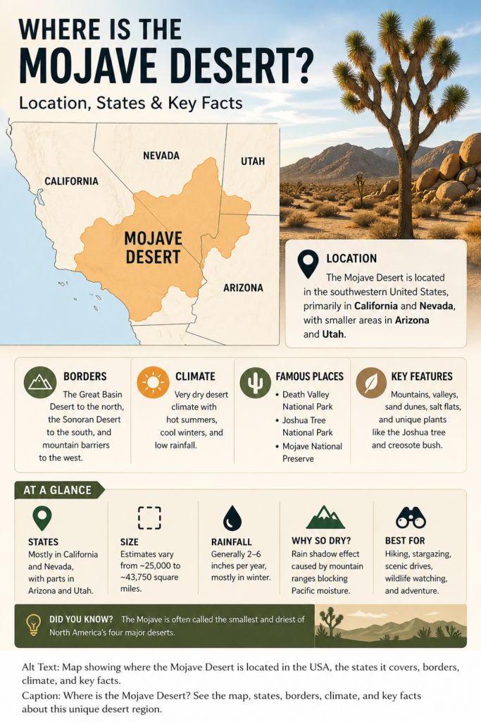
The Mojave Desert is located in the southwestern United States, primarily in California and Nevada, with smaller sections extending into Arizona and Utah. It lies between the Great Basin Desert to the north and the Sonoran Desert to the south, and its dry conditions are caused in large part by mountain ranges that block moisture and create a rain shadow.
Mojave Desert location on the map
On a map, the Mojave Desert appears as a broad inland desert zone in the interior Southwest. It does not follow neat state lines, city boundaries, or county borders. Instead, it stretches across a natural landscape shaped more by geology, climate, and elevation than by political divisions. That is one reason people sometimes struggle to visualize it clearly. It is not a single square or rectangle on the map. It is a living environmental region with a shifting footprint.
If you trace the Mojave visually, you will see that it occupies a central position among several major southwestern landscapes. It sits east of the Sierra Nevada, north of the Sonoran Desert, and west of higher plateau and basin regions. The surrounding mountain systems play a major role in its dryness by intercepting Pacific moisture before it can move far inland. This rain-shadow placement is one of the key reasons the region receives so little precipitation.
Another useful way to picture the Mojave is to think of it as a dry corridor between larger natural systems. It is not isolated in the sense of being cut off from everything around it. Instead, it forms a transition zone where different desert characteristics blend, overlap, and gradually shift. That is why some parts look more rocky and mountainous, while others feel flatter, more open, and more barren.
For readers trying to understand the region spatially, the simplest mental map is this: the Mojave occupies a large section of the American Southwest, with its strongest presence in southeastern California and southern Nevada, and smaller stretches crossing into neighboring states. It is best understood as a desert region defined by climate and ecology, not by strict political borders.
Which states does the Mojave Desert cover?
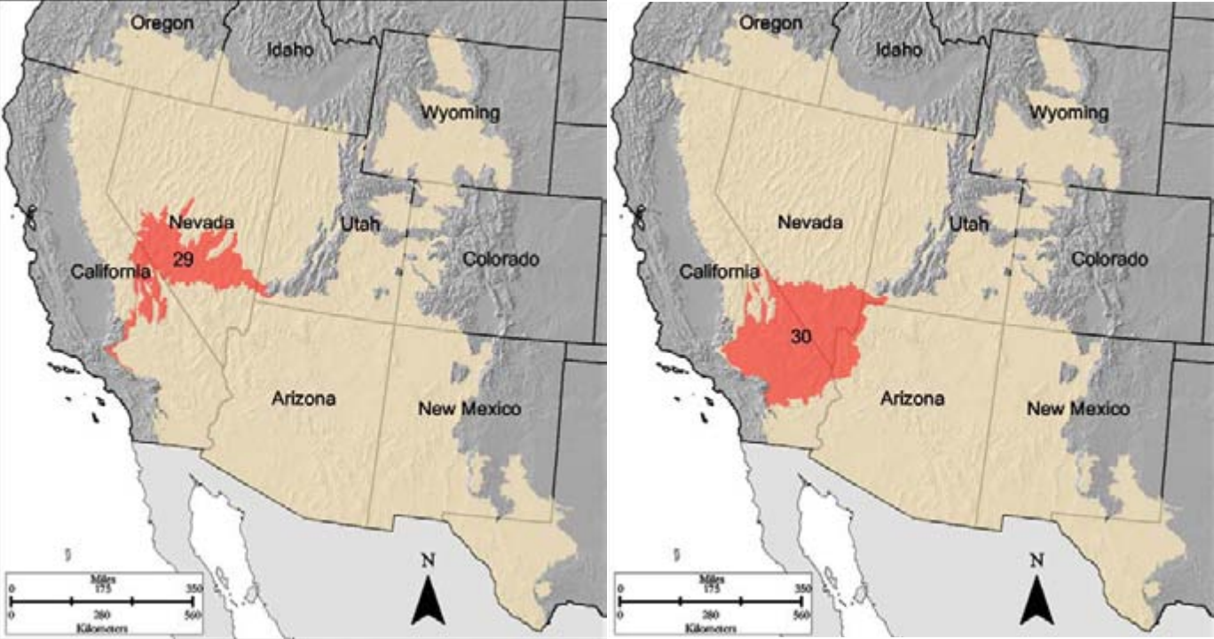
Most of the Mojave Desert lies in California, especially in the southeastern part of the state. Nevada also contains a substantial portion of the desert. Smaller areas extend into Arizona and Utah. This four-state spread is one of the reasons the Mojave is described both geographically and ecologically. Its extent cannot be reduced to a single state label without losing important context.
California contains the largest share of the Mojave, and many of the desert’s most familiar features are associated with the state’s inland southeast. Nevada includes a meaningful portion as well, especially in the southern part of the state. Arizona and Utah contain smaller sections, but those sections still matter because they reflect the desert’s broader ecological continuity.
This matters for search intent, too, because people often ask the question with different assumptions. Some are looking for a state-by-state answer. Others want a map-based explanation. Others simply want to know whether the Mojave is “in California only.” The accurate answer is that it is not limited to California. California has the largest portion, but the desert crosses into three other states as well.
A reader-friendly way to state it is this: the Mojave Desert is mostly in California and Nevada, with smaller extensions into Arizona and Utah. That phrasing is clear, accurate, and easy to understand.
What borders the Mojave Desert?
The Mojave Desert is framed by natural boundaries rather than political ones. Northward, it gradually merges into the Great Basin Desert, while southward it shifts toward the Sonoran Desert. On the western side, mountain ranges like the Sierra Nevada create the dry rain-shadow conditions that define the region. In some places, especially around Joshua Tree National Park, the boundary between desert systems becomes especially visible.
That is why the Mojave is often described as a transition zone. It does not have a sharp edge like a fence line. Instead, it shifts across elevation, rainfall, soils, and vegetation patterns. One area may look Mojave distinctly, while another nearby area may begin to show characteristics of a neighboring desert.
Joshua Tree National Park is one of the clearest examples of this boundary logic. The park sits where the Mojave and Colorado Desert meet, which makes it a natural teaching ground for understanding how deserts can overlap and transition. The landscape, plants, and climate patterns in that area make the boundary visible in a way that maps alone cannot fully show.
The important idea is that the Mojave is not boxed in by strict borders. It is a dynamic landscape region with ecological edges that gradually fade into adjacent desert systems.
Mojave Desert at a glance
| Key detail | What it means |
| Main location | Southeastern California and southern Nevada, with smaller parts in Arizona and Utah. |
| Main borders | The Great Basin Desert to the north, the Sonoran Desert to the south, and mountain barriers that create a rain shadow. |
| Climate | Very dry, with winter precipitation, hot summers, and strong temperature swings in many places. |
| Famous places | Death Valley National Park, Joshua Tree National Park, and Mojave National Preserve. |
| Boundary issue | Different sources draw ecological lines differently, so size estimates can vary. |
One reason this table is so useful is that it condenses the entire location story into a few high-value facts. The Mojave is a real geographic region, but it is not always measured with the same border logic by every source. That is completely normal in desert geography, where landforms and ecological zones shift gradually rather than ending abruptly.
Why do Mojave Desert size estimates differ?
This is one of the most important points to understand if you are writing a serious pillar article on the Mojave. Different sources give different size estimates because they are not always using the same definition of the desert. Some sources apply a narrower ecological definition. Others use a broader geographic one. As a result, the total area can change depending on where the boundary is drawn.
For example, one reference may describe the Mojave as covering a little over 25,000 square miles, while another may place it closer to 43,750 square miles. That difference does not mean one source is wrong. It means the sources are working with slightly different boundary rules.
This is a very useful nuance for readers because it shows that deserts are not always measured the way states or counties are measured. Desert edges are often transitional, especially where climate, altitude, and plant communities shift gradually from one ecological zone to another.
For a reader-friendly article, the key takeaway should be simple: the Mojave is a well-defined desert region in broad terms, but its exact size depends on whether a source is using a narrow ecological model or a wider geographic interpretation.
Why the Mojave Desert exists
The Mojave is a rain-shadow desert. Moist air moves in from the Pacific Ocean, but mountain ranges block much of that moisture before it can reach the interior Southwest. As the air rises over the mountains, it cools and drops much of its moisture on the windward side. By the time the air reaches the Mojave, it is much drier.
This is the central climatic engine behind the desert. The Mojave is not dry by accident. It is dry because of large-scale atmospheric movement, mountain barriers, and the geography of western North America. That combination creates one of the most recognizable arid environments in the country.
The timing of rainfall also matters. In deserts, not only the amount of precipitation but also the seasonal pattern is important. The Mojave typically receives most of its moisture in the cooler months, especially winter. That seasonal rhythm shapes plant growth, animal activity, and travel conditions.
In practical terms, this means the Mojave is a landscape of limited water, extreme evaporation, and high environmental stress. Species that live here must be adapted to conserve water, endure heat, and survive long dry periods.
Climate and weather patterns
The Mojave Desert has a dry climate, but that does not mean it is uniformly hot all the time. In fact, one of its defining traits is variation. Summers can be intensely hot, especially in low-elevation areas, while winters can bring freezing nights, strong winds, and even snow in higher elevations. This combination of heat, cold, and dryness makes the region more complex than its stereotype suggests.
The climate is also highly elevation-dependent. Lower valleys and basins can feel much hotter and more severe, while higher terrain can be cooler and more variable. That is why two places within the Mojave can feel dramatically different even when they are relatively close together.
The desert’s annual rainfall is low, generally measured in only a few inches. Most of that precipitation arrives in winter or early spring, which supports a short but crucial period of plant activity. The rest of the year can be extremely dry.
For travel planning, this matters a great deal. Visitors who assume every part of the Mojave feels the same can be caught off guard. A desert day may begin warm, turn hot, become windy, and then cool sharply at night. The weather in the region is not just extreme; it is changeable.
The best plain-language summary is this: the Mojave is mostly dry, often very hot, sometimes surprisingly cold, and strongly shaped by elevation.
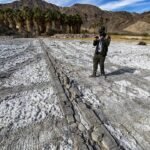
Landscape features: dunes, valleys, mountains, and salt flats
The Mojave is not a single flat expanse of sand. It is a complex landscape made up of basins, mountain ranges, dry lake beds, rocky slopes, salt flats, and, in some places, dunes. This variety is one of the reasons it is such an interesting place geographically. The desert is visually diverse, and its landforms create different microenvironments across relatively short distances.
Some sections feel open and expansive, with broad valley floors stretching into the distance. Other sections are rugged and broken, with jagged mountain ridges and rock-strewn slopes. Still others contain salt flats, dry basins, and areas where ancient water processes have left behind distinctive terrain. These differences are not random. They reflect long-term geologic forces and ongoing climate pressure.
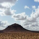
Death Valley is one of the strongest examples of Mojave landscape drama. It contains dramatic elevation contrasts, salt flats, basin structures, and some of the most extreme desert scenery in North America. It is often used as a reference point because it helps explain how the Mojave combines harshness with visual grandeur.
This is an important point for any article: the Mojave is a geographic system, not just a climate label. It is a land of physical structure, not simply a hot place with sand. Understanding the terrain helps readers understand the ecology, the climate, and the travel experience.
Plant life in the Mojave Desert
The plant life of the Mojave is built around conservation, resilience, and adaptation. The most iconic plant is the Joshua tree, which has become a symbolic species for the desert as a whole. It is one of the clearest visual identifiers of the region and is strongly associated with Mojave identity.
Creosote bush is another signature species. It is widely recognized across desert floors and is one of the toughest and most familiar shrubs in the desert environment. Other plants often associated with the Mojave include blackbrush, brittlebush, cholla, Mojave yucca, and desert almond. Each of these plants has evolved strategies to reduce water loss, survive heat, and take advantage of short wet periods.
At higher elevations, the plant community can change noticeably. Juniper, pinyon pine, and even white fir may appear in some areas, showing how the Mojave shifts with altitude. This is one of the best examples of why the desert is not a single uniform ecosystem. It contains multiple plant communities nested within one larger region.
A useful way to describe this in article form is to contrast a low desert floor with a higher mountain zone. The low areas may be dominated by creosote bush and Joshua tree, while the higher ground supports a very different set of species. This makes the Mojave feel like a layered ecological system rather than a single landscape type.
Animals of the Mojave Desert
The Mojave is full of life, even if much of that life is hidden, nocturnal, or well camouflaged. Many people imagine deserts as empty, but the Mojave tells a very different story. It supports a wide range of mammals, birds, reptiles, amphibians, insects, and arachnids.
Many desert animals are active at night or during cooler parts of the day. That behavior helps them avoid the harshest heat and conserve moisture. Rodents, bats, owls, foxes, skunks, and mountain lions are examples of animals that are often active when temperatures drop. This nocturnal pattern is one of the clearest adaptations to desert life.
Reptiles are especially well-suited to the Mojave because their bodies reduce water loss more effectively than those of many other animals. Lizards, snakes, and desert tortoises all belong to the region’s intricate food web. Birds also play important roles, using open terrain, thermal currents, seasonal movement, and nesting habits adapted to arid places.
The main point is simple: the Mojave is not empty. It is a functioning ecosystem with specialized forms of survival that are easy to miss unless you know where and when to look.
A simple table of common Mojave life
| Category | Example | Why it matters |
| Iconic plant | Joshua tree | It is the best-known symbol of the Mojave. |
| Hardy shrub | Creosote bush | It is common across desert floors and is extremely drought-tolerant. |
| Mammals | Foxes, bats, rodents | Many are nocturnal to avoid heat and conserve energy. |
| Reptiles | Tortoises, lizards, snakes | Their bodies are well adapted to dry conditions. |
| Birds | Owls, eagles, desert birds | They use open terrain and seasonal movement patterns. |
This table works because it shows the relationship between the organism and the environment. Every example is tied to survival under conditions of low water, intense sun, and temperature fluctuation.
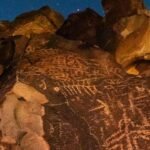
Human history and cultural meaning
The Mojave Desert is named after the Mojave people, an Indigenous group connected to the region. That origin matters. The desert is not just a physical environment; it is also part of a longer human story shaped by Indigenous presence, movement, memory, and identity. The name itself carries cultural history.
Human life in the Mojave stretches back thousands of years. The desert has long supported movement, adaptation, trade, and settlement. Modern park boundaries and road maps are recent developments compared with the much older human relationship to the land. That is why the Mojave should never be described as “empty” or “unused.” It has always been part of human life in one way or another.
The presence of protected lands also reinforces this point. Places like Mojave National Preserve do not simply protect scenery. They also protect stories, traces of human habitation, and a long continuity of relationship between people and desert systems.
For a strong article, cultural meaning should not be treated as a side note. It should be part of the desert’s identity from the start.
Famous places inside or tied to the Mojave Desert
Three names are especially important when talking about the Mojave: Death Valley National Park, Joshua Tree National Park, and Mojave National Preserve. These are the most recognizable places connected to the region, and they serve as practical anchors for readers trying to place the desert on a map.
Joshua Tree is one of the most useful examples because it sits where two desert systems meet. That makes it an excellent place to explain transition zones, ecological overlap, and boundary complexity. It also offers iconic scenery, cultural history, and impressive geology, which makes it valuable for travelers and educators alike.
Death Valley is another major landmark. It is famous for its extreme heat, broad salt flats, and dramatic landforms. It helps demonstrate why the Mojave is often associated with severity, but also with visual scale and geological power.
Mojave National Preserve adds a broader ecological and historical dimension. It shows that the desert is not only about a few famous landmarks. It is also a large, living region with habitat diversity, deep time, and cultural continuity.
Why the Mojave is sometimes called the smallest and driest desert
Several sources describe the Mojave as the smallest and driest of North America’s four major deserts. This description has become common because it captures the region’s character in one compact phrase. It is small enough to study carefully, but large enough to include a wide range of terrain, species, and climate conditions.
“Smallest and driest” is also useful rhetorically because it gives the Mojave a distinct identity. Readers immediately understand that the region is not just another desert. It is a particularly arid and geographically interesting one, which is why it appears so often in geography, ecology, and travel content.
That said, the phrase should still be used carefully and contextually. It is best understood as a general descriptor rather than a rigid scientific slogan. The deeper point is that the Mojave is one of the most distinctive deserts in the United States, and its scale and dryness are central to its identity.
Travel and tourism in the Mojave Desert
The Mojave is a major travel destination because it combines scenery, geology, ecology, and open space in a way few other landscapes do. For many visitors, the appeal lies in the contrast: starkness and beauty, silence and scale, simplicity and complexity.
Joshua Tree National Park is among the best-known places to visit in or near the Mojave. Its twisted trees, giant boulders, open desert views, and night skies make it one of the most iconic desert destinations in the country. It is also valuable because it highlights the meeting point of two desert ecosystems.
Death Valley offers a very different but equally powerful experience. Visitors encounter salt flats, dunes, heat, cliffs, basins, and enormous visual emptiness that feels almost otherworldly. It is one of the most dramatic desert environments in North America.
Mojave National Preserve adds a quieter, more spacious layer to the travel story. It is ideal for people who want hiking, photography, stargazing, geology, solitude, and slower exploration. The preserve shows that the Mojave is not only about famous attractions but also about the deep desert atmosphere.
The main travel warning is straightforward: the Mojave rewards preparation. Water, sun protection, route planning, and awareness of temperature swings are essential. The desert can be beautiful, but it is also unforgiving if underestimated.
Survival tips and desert challenges
The Mojave can be dangerous if visitors are careless or overly confident. Summers can bring severe heat, some places are extremely remote, water is limited, and services may be far apart. Winter conditions can also surprise people, especially in higher elevations where freezing temperatures, wind, or snow may appear.
That combination of risks means preparation is not optional. A short roadside stop, a photography outing, or a hiking trip can become difficult very quickly if a traveler does not account for distance, water use, and changing weather. The Mojave is a place where small mistakes can have large consequences.
It is useful to think of the desert as a landscape of extremes. Heat, dryness, elevation change, and isolation all shape the visitor experience. That does not mean people should avoid it. It means they should approach it intelligently and respectfully.
In practical terms, the desert teaches self-reliance. Good planning, realistic expectations, and awareness of the environment are part of the experience.
Environmental issues and conservation
The Mojave faces serious environmental pressure from climate change, habitat loss, drought, development, and rising temperatures. These pressures matter because desert ecosystems are often more fragile than they appear. A dry landscape may look tough, but its ecological balance can still be vulnerable.
Joshua trees have become an especially powerful symbol of this concern. Because they are so closely tied to the identity of the Mojave, their future is often discussed in relation to changing climate conditions. Their status has become a visible reminder that desert ecosystems are not static. They are living systems that respond to temperature, precipitation, and long-term environmental change.
Protected lands are therefore extremely important. Death Valley National Park, Joshua Tree National Park, and Mojave National Preserve all preserve habitat, scenery, cultural history, and scientific value. They are not only tourist destinations. They are conservation tools.
The bigger lesson is that the Mojave is both resilient and vulnerable. It has endured for a long time, but it is now under real stress. That makes it especially important in conversations about climate, conservation, and land management.
Interesting facts about the Mojave Desert
The Mojave is famous for being a transition desert. It sits between major desert systems and changes character across distance, elevation, and climate conditions. That is one reason its boundaries can be difficult to define with perfect precision.
It is also ecologically rich. Even though it is dry, it supports a wide variety of species, from mammals and birds to reptiles and insects. This shows that “desert” does not mean “lifeless.” It means adapted, specialized, and often hidden from casual view.
Joshua Tree National Park is one of the clearest places to understand the Mojave’s identity because it combines geology, ecology, and boundary overlap in one accessible location. It makes an excellent real-world example for readers who need a concrete mental image.
Another important fact is that the Mojave’s landscape diversity is greater than many people expect. It includes mountains, valleys, dry basins, dunes, salt flats, and varied plant communities. This diversity is what makes the desert so compelling to study and visit.
Pros and cons
Pros: The Mojave has an unmistakable identity, iconic national parks, strong scenic value, and a rich combination of geology, ecology, and history. It is also one of the best deserts for understanding how climate and elevation influence landscape and life.
Cons: It can be remote, harsh, and risky without proper preparation. Its exact boundaries also create confusion because different sources define it differently. On top of that, climate stress is creating real concerns for the future of the ecosystem.
FAQs
No. The Mojave lies mostly in California, but it also extends into Nevada, Arizona, and Utah. California contains the largest share, but it is not the only state involved.
Because the desert’s boundaries are not drawn the same way by every source. Some writers use a narrower ecological definition, while others use a broader geographic one. That is why the total area can vary from one source to another.
The Mojave transitions into the Great Basin Desert to the north and the Sonoran Desert to the south. In some places, it also meets the Colorado Desert, especially around transitional park regions.
The Joshua tree is the most iconic plant associated with the Mojave. Creosote bush is another major and highly recognizable desert plant across the region.
Yes. It is especially appealing to travelers interested in open landscapes, national parks, geology, photography, stargazing, and desert ecology. Visitors should, however, prepare carefully for heat, dry conditions, and remote distances.
Conclusion
The Mojave Desert is located mainly in southeastern California and southern Nevada, with smaller areas in Arizona and Utah. Defined by its dry climate and rain-shadow effect, it stands out as a key desert region shaped by geography, ecology, and Environmental extremes.