Introduction
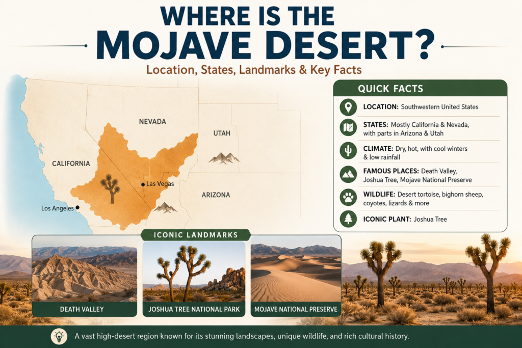
The Mojave Desert is one of the best-known desert regions in the southwestern United States. It is found mostly in southeastern California and southern Nevada, with smaller areas reaching into Arizona and Utah. Known for its dry climate, striking landscapes, and iconic Joshua trees, the Mojave is more than a point on the map. It is a vast high-desert region shaped by elevation, mountain barriers, wildlife, history, and travel routes. This guide gives a clear answer to the question of where the Mojave Desert is and explains why it matters.
Quick Answer: Where Is the Mojave Desert?
The Mojave Desert is in the southwestern United States. It lies mostly in California and Nevada, and it also reaches into Arizona and Utah. It is inland from Southern California and is bordered by other deserts and mountain systems that help create its dry, high-desert climate.
Quick Facts About the Mojave Desert
| Fact | Mojave Desert |
| Main location | Southeastern California and southern Nevada, with parts in Arizona and Utah |
| Climate | Dry, hot, and highly variable, with winter frosts and low precipitation |
| Famous places | Death Valley, Joshua Tree, Mojave National Preserve |
| Neighboring deserts | Great Basin Desert to the north; Sonoran Desert to the south and southeast |
| Ecological identity | Joshua trees are one of the best-known symbols of the Mojave landscape |
That quick snapshot answers the most common search intent. It also shows why people often connect the Mojave with Southern California road trips, Las Vegas travel, Death Valley, Joshua Tree, and desert ecology.
Where the Mojave Desert Is Located
Geographically, the Mojave occupies a large interior zone of the western United States. Britannica describes it as extending from the Sierra Nevada toward the Colorado Plateau and blending into the Great Basin Desert to the north and the Sonoran Desert to the south and southeast. In the southwest, it also meets mountain systems such as the San Gabriel and San Bernardino ranges. In practical terms, that means the Mojave is better understood as a broad desert region than as a neat, closed shape.
If you look at a map of the western United States, the Mojave appears inland from the coast and spreads across a wide belt of desert terrain. It is the region many travelers cross when driving between the Los Angeles area and Las Vegas, but that common highway image only tells part of the story. The Mojave also includes valleys, basins, mountain fronts, dry lakebeds, volcanic features, dune fields, and large protected lands.
A helpful way to picture the Mojave is as a transition zone. It sits between other desert systems and changes gradually at its edges instead of ending at a hard political line. That is why descriptions of its boundaries vary slightly from source to source, even when they agree on the overall location.
What States Is the Mojave Desert In?
The Mojave Desert spans four states: California, Nevada, Utah, and Arizona. California and Nevada contain the largest portions, while Utah and Arizona include smaller sections. The Nature Conservancy states this clearly, and educational material from Britannica also places the Mojave primarily in California while extending it into the other three states.
For most readers, California is the state most closely linked to the Mojave. Large parts of the desert lie in the state’s inland high-desert region, and many of the best-known destinations are there. Joshua Tree National Park, Mojave National Preserve, and the Death Valley area all help explain why the Mojave is such a frequent search topic for California desert travel.
Nevada is the other major state associated with the Mojave. Southern Nevada shares the desert’s dry climate and open basin-and-range scenery, and the region is often discussed in connection with travel around Las Vegas and the broader interior Southwest. The smaller areas in Arizona and Utah remind us that the Mojave is an ecological region, not a boundary line drawn around a map box.
Mojave Desert Map and Boundaries
The Mojave Desert map is easiest to understand as a broad inland desert zone in the southwestern corner of the United States. Its natural edges are shaped by mountains, climate, elevation, and vegetation rather than by state borders alone. Britannica notes that the desert merges with the Great Basin Desert to the north and the Sonoran Desert to the south and southeast, which is why its outer edges feel gradual rather than abrupt.
A map of the Mojave usually communicates three major ideas. First, the desert sits inland from the Pacific coast. Second, it stretches across parts of four states. Third, its identity is tied to high-desert conditions and key indicator plants, especially Joshua trees. The Nature Conservancy and Joshua Tree National Park both reinforce that the desert’s ecology is a core part of what defines it.
Mojave Desert vs. Neighboring Deserts
| Desert | Where it sits | Main identity |
| Mojave Desert | Southwestern U.S., mainly southeastern California and southern Nevada | High-desert region with Joshua trees, low rainfall, and large elevation swings |
| Great Basin Desert | North of the Mojave | Cooler, higher-elevation desert |
| Sonoran Desert | South and southeast of the Mojave | Warmer low desert with different plants and climate |
This comparison helps readers see why the Mojave stands apart. It is not the hottest desert in every location, and it is not the only desert in the Southwest, but it is one of the clearest examples of a high desert with a strong ecological identity.
How Big Is the Mojave Desert?
The Mojave is a very large desert region. The Nature Conservancy says California alone contains about 20 million acres of Mojave Desert land, which is roughly one-fifth of the state. That scale alone shows why the Mojave matters so much in geography, conservation, and travel.
Its size also explains why the landscape feels so varied. A single journey can move through dry basins, rocky foothills, mountain passes, dune fields, lava landscapes, and open plains. The Mojave is not one flat empty stretch of sand. It is a wide ecological zone with many different terrain types and many different microhabitats.
Why the Mojave Is Called a High Desert
The Mojave is often described as a high desert Because much of it sits at a higher elevation than classic low deserts. That elevation affects how the climate feels. Days may be hot, but nights cool down quickly, and winter frosts are common in many places. Britannica specifically describes the region as having extreme temperature variation and frequent winter frosts.
The high-desert character is also tied to the rain shadow effect. In Southern California, mountains block moist Pacific air, so far less moisture reaches the desert interior. Joshua Tree National Park explains that high mountains force air to rise, cool, and drop precipitation before it reaches the desert. USGS notes that daily high and low temperatures in Joshua Tree can differ by as much as 50°F because of the arid climate and nearby mountains.
Climate and Weather Patterns in the Mojave Desert
The Mojave has a desert climate defined by dryness, bright sunlight, and pronounced temperature swings. Britannica says the region has hot summers, cool winters, frequent winter frosts, and an average annual precipitation of about 2 to 6 inches. That is a very small amount of moisture for such a large landscape, which is why water is always a central factor in desert life.
The climate changes from place to place depending on elevation and location. Some areas are low, hot, and exceptionally dry, while others are higher and noticeably cooler. Death Valley is the most dramatic example. The Nature Conservancy notes that Badwater Basin sits 282 feet below sea level, while the Panamint Mountains rise to more than 11,000 feet. That enormous range helps explain why the Mojave can feel like several deserts in one.
Climate Snapshot
| Climate factor | Mojave Desert pattern |
| Rainfall | Very low, often only a few inches a year |
| Temperature | Hot summers, cool winters, strong day-night swings |
| Winter weather | Frost can happen, especially in higher areas |
| Main climate driver | Rain shadow effect and elevation differences |
This climate profile is one of the biggest reasons the Mojave draws both scientists and travelers. It is beautiful, demanding, extreme, and constantly shaped by contrast.
Landscape Features: Sand Dunes, Rocks, Valleys, and Salt Flats
The Mojave is much more than sand. It includes mountain ranges, rocky basins, dry lakebeds, dunes, canyons, lava fields, and playas. Mojave National Preserve describes the area as a diverse mosaic of ecological habitats, while National Park Service geodiversity materials show that the preserve preserves a geologic record that reaches back billions of years.
One of the most famous locations in the region is Death Valley. The National Park Service calls it the hottest, driest, and lowest national park. The park also highlights a striking mix of below-sea-level basins, high peaks, wildflower blooms after rain, desert oases, and rugged landforms. That combination is a perfect example of the Mojave’s dramatic range.
Another major landmark is Mojave National Preserve, where visitors can see the Kelso Dunes, volcanic terrain, and the Lava Tube area. NPS says the preserve includes dunes, the Cima volcanic field, and other scenic desert features that make the landscape feel remote, spacious, and visually diverse. It also protects a vast area of public land with important natural and cultural history.
Flora: Plants of the Mojave Desert
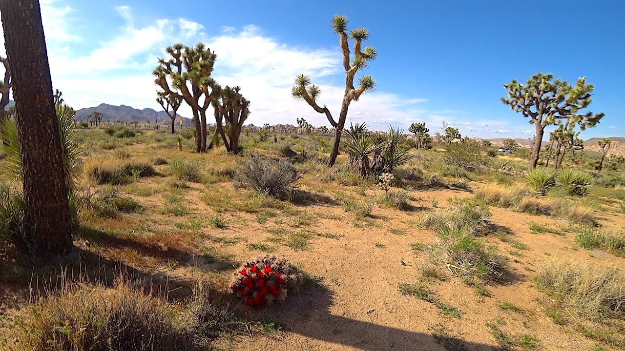
The plant most people associate with the Mojave is the Joshua tree. National Park Service and USGS materials both show why it matters so much. Joshua Tree National Park explains that the region is a rain shadow desert, and the park exists partly to protect the Joshua tree, which is a defining part of the Mojave ecosystem. In simple terms, when people think of the Mojave, they often picture a Joshua tree because it has become one of the clearest symbols of the desert’s identity.
Other Mojave plants include creosote bush, palo verde, ironwood, ocotillo in warmer transition zones, and a variety of shrubs and cacti depending on elevation and soil. The plant mix changes from place to place because the desert is not uniform. Joshua Tree National Park and Mojave National Preserve both demonstrate that plant communities shift with climate, topography, and water availability.
These plants survive by being remarkably efficient with water. Some store moisture, some grow slowly, and some bloom rapidly after rainfall. That is why the Mojave may appear empty at first glance, but actually supports a highly adapted and resilient plant community beneath that dry surface impression.
Fauna: Animals of the Mojave Desert
The Mojave supports a surprisingly rich range of wildlife. Even though the landscape can look harsh, it is home to desert tortoises, kangaroo rats, coyotes, bobcats, bighorn sheep, mule deer, foxes, bats, lizards, snakes, birds, and many insects. Mojave National Preserve notes that wildlife diversity is closely tied to variation in elevation, precipitation, and vegetation communities that supply food, shelter, and water.
The desert tortoise is one of the best-known Mojave species. The U.S. Fish and Wildlife Service says the Mojave population lives in a wide range of habitats, including sandy flats, rocky foothills, alluvial fans, washes, and canyons. That broad habitat range shows how closely the tortoise is linked to the structure of the desert itself.
The tortoise is also one of the species most affected by human pressure. USFWS and NPS materials point to threats such as habitat loss, fragmentation, wildfire, invasive vegetation, road mortality, and broader development impacts. That makes the tortoise a powerful example of why conservation in the Mojave matters.
Birds are also important in the desert, especially around springs, washes, and riparian corridors. Mojave National Preserve emphasizes that water sources and habitat links help support a wide range of species. In a dry landscape, even a small spring can become a major life-support system.
Human History and Cultures in the Mojave Desert
The Mojave is not an empty wilderness. It has a long human history, and the National Park Service says the preserve reflects roughly 10,000 years of human connection with the desert. That includes Indigenous communities, trade paths, travel corridors, settlement, mining, rail history, and modern conservation efforts.
The region has deep ties to Indigenous peoples, including the Mojave and Chemehuevi peoples. NPS materials on the preserve and nearby park lands show that desert travel routes were vital long before modern highways were built. These routes connected communities, supported exchange, and helped people move through an environment that outsiders often misread as empty.
Later history brought railroads, mining, ranching, and military use to portions of the desert. Today, historical interpretation in the region helps visitors understand the Mojave as both a natural system and a human story. That matters because the desert is not only about climate and plants. It is also about memory, movement, adaptation, and survival.
Famous Mojave Desert Landmarks
When people search for the Mojave Desert, they often also want to know what famous places define it. Three of the most important are Death Valley, Joshua Tree National Park, and Mojave National Preserve. Each shows a different dimension of the desert. Death Valley represents the extremes. Joshua Tree represents the ecological edge and its iconic tree species. Mojave National Preserve represents the wide-open, remote desert experience.
1) Death Valley National Park
Death Valley is one of the most famous places in the Mojave. NPS calls it the hottest, driest, and lowest national park. USGS notes that it is the driest place in North America and says some areas receive less than two inches of rain per year. This is the place many people picture when they hear the word “Mojave,” even though the desert includes much more than one park.
2) Joshua Tree National Park
Joshua Tree sits at an important ecological meeting point, and the park’s desert page explains that southeastern California is a rain shadow desert. The Joshua tree itself has become an emblem of the Mojave, and FWS notes that climate change and invasive grasses are increasing fire risk for Joshua tree habitat. That makes the park both a travel icon and a conservation priority.
3) Mojave National Preserve
Mojave National Preserve is one of the clearest windows into the desert’s open, spacious character. NPS says the preserve holds a diverse mosaic of ecological habitats, a 10,000-year history of human connection, current road and weather updates, maps, camping information, and desert travel guidance. It is also where visitors can see landmarks such as Kelso Dunes and the Lava Tube.
Things to See and Do in the Mojave Desert
The Mojave is a major destination for desert travel because it combines scenery, geology, wildlife, and history. NPS trip ideas highlight Kelso Dunes, cinder cones and lava flows, Teutonia Peak, Boulders Viewpoint, Hole-in-the-Wall, and stargazing. That makes the preserve a strong choice for travelers who want more than a roadside stop.
Kelso Dunes are one of the best-known experiences in the preserve. NPS says the dunes are over 600 feet tall, are the preserve’s most popular hike, and can even produce a booming sound under the right conditions. The same page also warns that summer hiking is not recommended because temperatures can reach 120°F. That is a clear reminder that Mojave beauty and Mojave safety must go together.
The Lava Tube area is another popular stop, but NPS notes that it is reached by an unpaved road and recommends high-clearance vehicles. That kind of guidance is exactly why travel content for the Mojave should be practical, not only inspirational. Desert travel works best when readers know what to expect before they go.
Travel Tips for Visiting the Mojave Desert
Visiting the Mojave can be unforgettable, but it requires preparation. The National Park Service repeatedly advises visitors to check road conditions, use official maps, and plan carefully because the preserve is remote. It also provides camping and current-condition information for travelers. In the desert, those basics are not optional; they are essential.
The smartest travel habits are simple. Start early in hot weather. Carry more water than you think you need. Keep your fuel tank full. Do not assume that phone service will be reliable. Respect the trail and road conditions. These are not dramatic tips, but they matter because the Mojave’s distances and weather can quickly turn a normal outing into a risky situation.
Practical Safety Guide
| Situation | Smart move |
| Hot-weather hiking | Start early and carry extra water |
| Remote driving | Keep the tank full and check road conditions |
| Night travel | Expect colder temperatures after sunset |
| Wildlife viewing | Watch from a distance and do not disturb the habitat |
| Off-road or dirt-road travel | Use a suitable vehicle and follow park guidance |
This kind of travel guidance transforms a broad geography article into something genuinely useful. Readers do not just learn where the Mojave is. They also learn how to experience it responsibly and safely.
Conservation and Environmental Challenges
The Mojave is visually stunning, but it is also under pressure. The Nature Conservancy says the western deserts represent the largest intact ecosystem in the contiguous 48 states, which shows how important this region is from a conservation standpoint. At the same time, development, habitat fragmentation, and energy projects continue to shape the desert’s future.
Fire and climate stress are major issues. FWS says Joshua tree habitat is threatened by a warming climate, more severe droughts, and invasive grasses that increase fire frequency, size, and intensity. That matters because desert ecosystems often recover slowly after disturbance, and some plant communities may never bounce back the way people expect.
The desert tortoise is another major conservation focus. USFWS monitoring materials and related science show that the species is tracked across the Mojave region and faces habitat risks from development and land use change. In some places, road closures and route restrictions are used to protect the tortoise and other sensitive desert life.
Conservation in the Mojave is therefore not simply about one plant or one animal. It is about keeping an entire desert system connected, resilient, and functional. That includes wildlife habitat, cultural sites, travel corridors, and the big open spaces that give the region its identity.
Interesting Facts About the Mojave Desert
The Mojave has several features that make it stand out in any geography guide. One of the most striking is its elevation contrast. The Nature Conservancy says Badwater Basin is the lowest point in the U.S. at 282 feet below sea level, while nearby mountains rise to more than 11,000 feet. That is an extraordinary difference for a single desert region.
Another important fact is that the Mojave sits in a key ecological transition zone. Britannica and Joshua Tree National Park both show that climate and vegetation change as elevation and mountain barriers shift. That helps explain why the desert can contain such different environments as low basins, dunes, volcanic fields, and Joshua tree woodlands.
A third fact is that the Mojave is not only a travel destination. It is also a scientific and conservation landscape. The park service, USGS, FWS, and The Nature Conservancy all treat it as an important ecological region with long-term value. That is a strong signal that the Mojave deserves more than a one-line map answer.
Pros and Cons
Pros
The scenery is memorable, with dunes, mountains, dry basins, and wide open skies.
It includes famous landmarks like Death Valley, Joshua Tree, and Mojave National Preserve.
Wildlife and plant life are richer than many visitors expect.
It offers excellent photography, hiking, stargazing, and road-trip potential.
Cons
Heat, dryness, and remote roads can make travel dangerous without preparation.
Services may be spread far apart, especially in preserved areas.
The ecosystem is fragile and can recover slowly from damage.
FAQs
Yes. Most of the Mojave Desert is in California, especially in the southeastern and high-desert parts of the state.
Yes. The Mojave also extends into southern Nevada, which is why it is often linked with desert travel around the Las Vegas region.
Yes. Death Valley is one of the best-known places in the Mojave Desert and a key landmark for understanding the region’s extremes.
It is called a high desert because much of it sits at relatively higher elevations, which creates cooler nights, winter frosts, and strong temperature swings.
It is famous for Joshua trees, Death Valley, its dry climate, dramatic landscapes, and major protected areas such as Joshua Tree National Park and Mojave National Preserve.
Conclusion
So, where is the Mojave Desert? It is a major high-desert region in the southwestern United States, centered mainly in California and Nevada, with smaller portions in Arizona and Utah. Its boundaries are shaped by climate, elevation, and surrounding desert systems, not just state lines. From Death Valley to Joshua Tree and Mojave National Preserve, the Mojave stands out for its dramatic scenery, unique ecology, and lasting importance for travel, conservation, and history.


