Introduction
When people search for desert states in the US, they usually want a simple answer: which states contain deserts and what makes them desert landscapes. The truth is a little broader than a basic list. Several western states have major desert regions, while others include smaller high-desert areas Connected to the larger desert West. This guide gives a clear breakdown of the main desert states, the four major desert systems, and why these regions matter.
Overview: What Are Desert States in the US?
When people say desert states, they often mean the states most closely associated with desert climate, desert scenery, and desert travel. But not every desert state is desert from one border to the other. In many cases, only a portion of the state is arid, semi-arid, or high desert.
That is why the phrase works best when you think of it in three ways:
Desert-heavy states — states with extensive desert regions and a strong desert identity.
Desert-border states — states that contain major desert land but also include forests, mountains, grasslands, or coastlines.
Desert-fringe states — states with some high desert, dry basin country, or transitional arid zones that connect to larger desert systems.
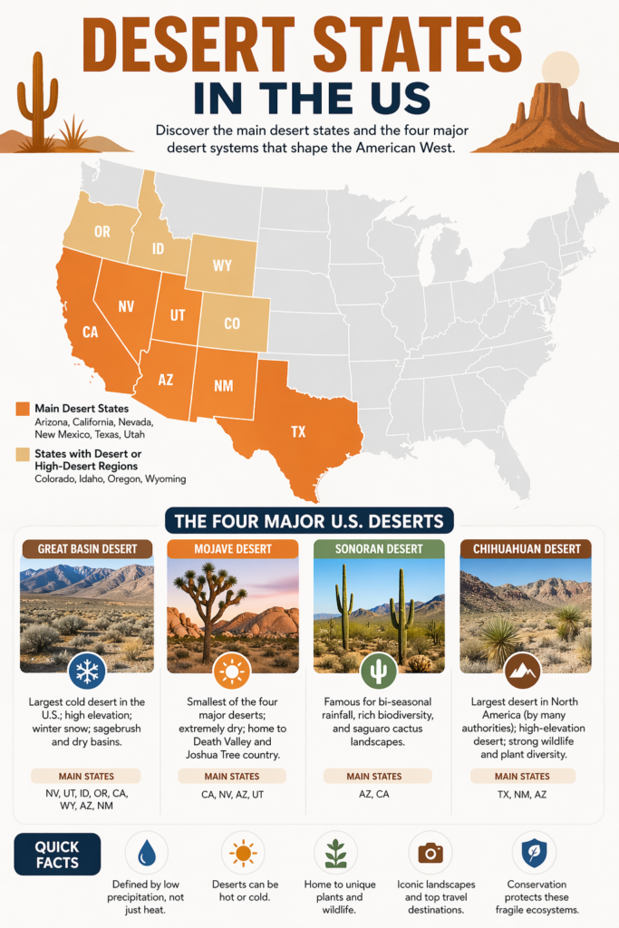
In the United States, the most widely recognized desert states are:
Arizona
California
Nevada
New Mexico
Texas
Utah
In broader geographic discussions, parts of Colorado, Idaho, Oregon, and Wyoming are also included because they connect to the Great Basin and to the wider desert West. This wider view matters because desert geography does not stop at state lines. Climate zones, rain shadows, elevation changes, and landforms cross borders in a way that makes the desert region a connected system rather than a neat political outline.
So the real answer is not just a list. It is a landscape story. Deserts shift with altitude. They behave differently depending on rainfall, snowfall, soil type, wind patterns, and mountain barriers. That is what makes the topic valuable for readers and powerful for SEO.
What Makes a Place a Desert?
A desert is not defined by heat alone.
That is one of the biggest misconceptions people have. Many readers imagine a desert as a place of burning temperatures, endless sand, and nothing but glare. In fact, a desert is mainly defined by low precipitation. If a region receives very little rainfall or snowfall over time, it can be classified as a desert even if it is cold.
This is why the Great Basin Desert matters so much. It is a cold desert, which means winter snow can be part of the climate. It is still a desert because moisture is limited. The same idea explains why some deserts are blisteringly hot, some are high-elevation plateaus, and some contain rocky valleys rather than dunes.
A desert can include:
dunes
salt flats
gravel plains
rocky slopes
mountain ranges
dry washes
cactus fields
sagebrush valleys
lava fields
basins and canyons
So when we talk about desert states in the US, we are really talking about a large family of dry landscapes that look very different from one another but still share the same core environmental condition: not enough water.
Quick Answer: Which States Have Deserts?
Here is the simple state-by-state answer.
The main desert states in the US
Arizona
California
Nevada
New Mexico
Texas
Utah
States with desert or high-desert regions in broader maps
Colorado
Idaho
Oregon
Wyoming
This list matters because many searchers are not asking whether the entire state is desert. They want to know whether the state includes desert land, major desert parks, iconic desert scenery, or desert travel destinations.
The Four Major U.S. Deserts at a Glance
| Desert | Main U.S. States | What Makes It Special |
| Great Basin Desert | Nevada, Utah, Idaho, Oregon, California, Wyoming, Arizona, New Mexico | Largest cold desert in the U.S.; high elevation; winter snow; sagebrush and dry basins |
| Mojave Desert | California, Nevada, Arizona, Utah | Smallest of the four major deserts; extremely dry; home to Death Valley and Joshua Tree country |
| Sonoran Desert | Arizona and California | Famous for bi-seasonal rainfall, rich biodiversity, and saguaro cactus landscape |
| Chihuahuan Desert | Texas, New Mexico, Arizona | Largest desert in North America, according to many authorities; high-elevation desert; strong wildlife and plant diversity |
This table gives readers the fast answer they came for. But the deeper value comes from understanding how each desert feels on the Ground, how each ecosystem works, and why each one matters in the larger map of the American Southwest.
Desert States in the US: State-by-State Breakdown
Arizona
Arizona is one of the most iconic desert states in the US.
Why? Because a large part of the Sonoran Desert lies in the southern third of the state. Arizona also connects to other dry regions and desert transition zones. That is why the state appears in nearly every search about desert maps, desert wildlife, desert road trips, and desert travel.
Arizona is known for:
saguaro cactus landscapes
dry mountain valleys
desert wildlife
mild winter travel
national parks and monuments
long scenic drives
Arizona is not a desert state only because it is hot. It is a desert state because desert conditions shape its identity. Its southern lands are deeply influenced by arid climate, sparse rainfall, and resilient ecosystems. That gives Arizona a central place in any article about desert states in the US.
Why Arizona stands out
strong Sonoran Desert presence
iconic cactus scenery
popular desert routes and parklands
clear desert identity
excellent travel appeal
California
California contains major desert regions in both the Mojave Desert and the Sonoran Desert.
The state’s southeastern and southern desert lands are among the most visited in the country. Travelers know California for places such as Death Valley, Joshua Tree, and Mojave National Preserve. These destinations give California a major role in desert tourism, scenic photography, and nature travel.
California’s desert zones are famous for:
dramatic heat extremes
dunes and salt flats
Joshua trees
dry basins
mountain-and-valley scenery
protected parklands
A lot of people think of California only as coastal, urban, or forested. But the desert side of California is just as important. It adds depth to the state’s geography and gives it a leading position in any discussion of desert states in the US.
Nevada
Nevada is often the clearest Great Basin Desert state.
A large part of Nevada lies within the Great Basin region, which gives the state its classic high-desert identity. The state also overlaps with the Mojave Desert in the south. That is why Nevada feels like a place of wide-open basins, mountain blocks, dry valleys, and long-distance horizons.
Nevada’s desert character includes:
high desert landforms
sparse vegetation
long dry distances
cold desert areas
basin-and-range geography
Nevada is one of the best examples of how desert geography is tied to elevation and rain shadows, not simply to heat. It belongs in any serious discussion of desert states because it shows the structure, scale, and complexity of the western arid zone.
New Mexico
New Mexico is one of the strongest Chihuahuan Desert states in the United States.
The state includes major desert lands, high desert plateaus, and famous natural landmarks such as White Sands. It also connects to larger desert systems across the Southwest. For many readers, New Mexico is the perfect example of a desert state that combines dry climate, open space, and deep cultural history.
New Mexico is known for:
desert basins
high desert plateaus
gypsum dunes
cactus and shrub ecosystems
mountain-desert transitions
strong tribal and cultural landscapes
New Mexico shows that desert states are not empty. They are full of history, identity, movement, and ecological richness. That makes the state highly relevant in search intent, travel planning, and educational content.
Texas
Texas is one of the most important states in the Chihuahuan Desert conservation.
The Trans-Pecos region and the Big Bend area are central to Texas desert identity. In fact, the desert lands in far West Texas are some of the most striking in the country. They include mountains, rivers, canyons, open desert, and protected wilderness.
Texas desert regions are known for:
Big Bend landscapes
desert wildlife
remote road trips
rugged mountain-desert scenery
strong ecological variety
Texas matters because it proves that desert country is not limited to the postcard version of the Southwest. The desert reaches into the western edge of the state and shapes the landscape in a powerful, memorable way.
Utah
Utah is a major desert state, even though many people first think of it as canyon country.
The state contains desert zones linked to the Great Basin and Mojave systems, especially in western and southern Utah. This is why Utah is often described as a place of red rock, mesas, dry plateaus, and high desert terrain.
Utah’s desert side includes:
Red Rock Country
canyon systems
dry valleys
high desert plateaus
national parks and scenic byways
Utah is very important for travel content because it connects desert geography with some of the most photogenic landscapes in the United States. It shows that desert terrain can be dramatic, colorful, and visually rich.
Colorado
Colorado is not usually called a classic desert state, but parts of it belong in broader desert-region discussions.
Some areas connect to dry interior landscapes, high desert zones, and the wider Great Basin and Southwest arid systems. That is why Colorado sometimes appears in ecological maps and regional geography guides, even when it is not the first state people think of.
Colorado matters because it reminds readers that desert geography does not always follow state labels in a neat, simple way. Real landscapes often cross boundaries and blend into neighboring ecosystems.
Idaho
Idaho is another state that appears in broader Great Basin Desert discussions.
Most people know Idaho for mountains, rivers, and agriculture, but parts of the state are also connected to dry interior desert landscapes. That makes Idaho useful when discussing the western desert region in a wider sense.
Idaho reinforces the idea that desert maps are about climate patterns and landform systems, not just about popular stereotypes. The desert West is more spread out and more diverse than many readers expect.
Oregon
Oregon may surprise some readers, but it contains parts of the broader Great Basin and dry interior desert systems.
This is a strong example of why desert geography is more complex than simple assumptions. Not all deserts are hot. Not all deserts look like dunes. And not all desert states are known only for cactus, sand, and intense summer temperatures.
Oregon shows the value of a broader geographic lens. It demonstrates that arid interior land can exist in a state better known for forests, rain, and coastline.
Wyoming
Wyoming also belongs in broader desert-region discussions because parts of the state connect to the Great Basin and dry high-desert zones.
Like Idaho and Oregon, Wyoming proves that the desert West is a wide geographic system, not just a list of the most famous tourist destinations. The state is part of the larger ecological picture, even if it is not the first one people mention in a casual conversation about desert scenery.
The Four Major Deserts in the US Explained
1. Great Basin Desert
The Great Basin Desert is the largest cold desert in the United States.
That single fact makes it one of the most important parts of any article about desert states in the US. A desert is not defined by extreme heat, but by low moisture, elevation, and climate patterns. Many desert regions experience cold winters, including snowfall. This makes them a strong example of how a landscape can be cold, elevated, and still qualify as true desert terrain.
Key features of the Great Basin Desert
cold desert climate
high elevation
winter snow
sagebrush and dry grasslands
mountain ranges and basin floors
sparse but resilient plant life
The Great Basin is a powerful example of desert diversity. A traveler may see broad valleys, rugged mountain ranges, sagebrush plains, and silent winter scenery, all within one desert system. It is a landscape of space, contrast, and endurance.
Why it matters
The Great Basin shows that a desert can be snowy, cool, and high-altitude while remaining truly arid.
2. Mojave Desert
The Mojave Desert is one of the driest and most extreme deserts in the United States.
It is strongly associated with southeastern California, but it also extends into parts of Nevada, Arizona, and Utah. It is famous for harsh climate conditions, powerful heat, and dramatic desert scenery.
Key features of the Mojave Desert
extremely dry climate
hot summer conditions
Joshua tree habitats
salt flats and dry basins
desert mountains
famous parklands and preserves
The Mojave is the desert many people picture first when they imagine the American Southwest: bright sun, open roads, rough rock formations, and long stretches of empty-looking land that are actually full of ecological detail.
Why it matters
The Mojave is important because it contains some of the most recognizable desert views and travel destinations in the country.
3. Sonoran Desert
The Sonoran Desert is one of the most biologically rich deserts in the world.
It is famous for bi-seasonal rainfall, which means it can receive moisture in both winter and summer. This rainfall pattern supports a wider range of plants and animals than many people expect from a desert. It is one of the best examples of an ecosystem that is dry but not lifeless.
Key features of the Sonoran Desert
bi-seasonal rainfall
warm climate
saguaro cactus forests
high biodiversity
desert wildlife diversity
strong borderland identity
The Sonoran is often described as one of the richest deserts in terms of living organisms. It does not look empty. It looks vibrant, adapted, and ecologically active. This is one reason it is so valuable in both educational and travel-focused content.
Why it matters
The Sonoran Desert proves that desert does not mean sterile, lifeless, or barren.
4. Chihuahuan Desert
The Chihuahuan Desert is widely described as the largest desert in North America by many authorities.
It covers a huge region across the southwestern United States and northern Mexico. In the U.S., it is strongly linked to Texas, New Mexico, and parts of Arizona.
Key features of the Chihuahuan Desert
high-elevation desert zones
strong biodiversity
dry but varied terrain
important wildlife habitat
major protected areas like Big Bend and White Sands
The Chihuahuan Desert is often less famous in general pop culture than the Mojave or Sonoran, but it is just as significant. It has major ecological value, conservation importance, and travel appeal. It is one of the richest regions for understanding how desert systems operate across broad scales.
Why it matters
The Chihuahuan Desert shows how large, varied, and biologically important North American desert systems can be.
Climate and Weather in Desert States
A true desert is usually defined by low precipitation, not just by high temperature.
That means a desert can be hot, cold, windy, rocky, or snowy. The key factor is limited moisture. This is why desert states in the US can include places with very different weather patterns and still fit the same broad desert definition.
Main climate patterns in desert states
low annual rainfall
strong sun exposure
dry air
large day-night temperature swings
seasonal variation in some regions
mountain rain shadows
The Great Basin climate
The Great Basin is a cold desert. Winters can bring snow, and the land can remain very dry overall. This makes it one of the best examples of why a desert is not the same thing as hot weather.
The Mojave climate
The Mojave is known for intense heat and dryness. It is one of the harshest environments in the American desert system.
The Sonoran climate
The Sonoran receives rainfall in more than one season. That makes it more complex, more productive biologically, and more visually varied than many people assume.
The Chihuahuan climate
The Chihuahuan is dry but often high-elevation and ecologically rich. It combines desert conditions with altitude, seasonal shifts, and impressive biodiversity.
Landscape Features You Can See in Desert States
Desert landscapes are much more interesting than many people expect.
When readers hear the word “desert,” they often imagine only sand. But real desert states include many landforms and visual patterns that make the region far more dynamic.
Common desert landforms
dunes
salt flats
canyons
mesas
mountain ranges
dry lakes
rocky plains
volcanic fields
alluvial fans
dry riverbeds
These features matter because they make desert maps and desert travel guides much more useful. A strong pillar article should help readers picture the land, not just memorize names.
Examples of famous desert landscapes
Death Valley: dramatic basin scenery and extreme heat
Joshua Tree: unique desert plant life and rocky terrain
White Sands: bright gypsum dunes
Big Bend: broad desert scale and rugged mountains
Great Basin National Park: cold desert scenery and dark skies
These places show why desert states are such a major part of U.S. geography, tourism, and outdoor recreation.
Flora: Plants That Define Desert States
Desert plants survive in difficult conditions. They deal with heat, dryness, poor soil, and long periods between rain events.
How desert plants survive
deep roots
waxy surfaces
small leaves
water storage
slow growth
drought tolerance
seasonal timing
Plants in the Sonoran Desert
The Sonoran is famous for saguaro cactus and other striking desert plants. Its rainfall pattern supports more plant life than many other deserts.
Plants in the Mojave Desert
The Mojave is known for Joshua trees and other drought-resistant species. The vegetation is tougher, more scattered, and deeply adapted to heat and dryness.
Plants in the Great Basin Desert
The Great Basin has a very different plant mix. Instead of giant cacti, you see sagebrush, grasses, pinyon-juniper woodland, and other species adapted to cold, dry conditions.
Plants in the Chihuahuan Desert
The Chihuahuan contains cacti, succulents, shrubs, and other desert plants that thrive in dry, high-elevation terrain. Some species are highly specialized to microclimates and local soil conditions.
Important point
Deserts are not plant-less. They are plant-adapted, drought-smart, and ecologically specialized.
Fauna: Animals, Reptiles, Birds, and Insects in Desert States
Desert wildlife survives by being clever, fast, hidden, nocturnal, or active during cooler parts of the day.
Common desert animals
coyotes
foxes
jackrabbits
kangaroo rats
roadrunners
lizards
snakes
bats
owls
desert birds
insects and pollinators
How desert animals survive
Many desert animals are nocturnal or crepuscular, meaning they are active at night or during dawn and dusk. This helps them avoid the hottest part of the day and conserve water and energy.
Wildlife examples by region
Mojave: reptiles, birds, small mammals, and desert-adapted predators
Sonoran: a wide variety of insects, reptiles, birds, and mammals
Great Basin: species adapted to cold winters and dry summers
Chihuahuan: mule deer, peccary, jackrabbit, roadrunner, kangaroo rat, rattlesnake
Why wildlife matters
Desert states are not empty. They are full of life that has evolved to survive with very little moisture.
Human History and Culture in Desert States
Deserts were never empty lands.
Long before modern tourism, Indigenous peoples lived in and moved through these regions. They created homes, trade routes, food systems, art, seasonal movement patterns, and cultural traditions that remain important today.
Why this matters
A strong article about desert states in the US should not treat deserts only as scenic backdrops. They are homelands, working landscapes, cultural spaces, and living histories.
Desert history includes:
Indigenous lifeways
Spanish exploration
ranching and settlement
mining history
conservation and park creation
modern tourism and land stewardship
This means desert geography belongs in human history as much as it belongs in physical geography.
Why the Term “Desert States” Is Useful, but Imperfect
The phrase desert states is useful because it helps readers find the right content quickly. But it is also imperfect.
Pros
fast and simple search phrase
Good for travel and geography readers
helps people compare states
useful for maps and educational content
Cons
not an official scientific category
can imply that an entire state is a desert
desert boundaries are not always clear
Different sources may define desert regions differently
So the best way to use the term is carefully. It works well as a search label and a reader-friendly shortcut, not as a strict legal or scientific category.
Desert Travel Tips for Visitors
Traveling through desert states is exciting, but it requires smart planning.
The desert can look calm and simple, but it can become dangerous if visitors are unprepared.
Simple desert travel tips
carry more water than you think you need
start early in the day
Use sun protection
Check park alerts
Keep a map or GPS
Do not rely on cell service.
Avoid long exposure during peak heat.
Watch for sudden weather shifts
What makes desert travel tricky
heat can rise fast
roads may be long and isolated
shade may be limited
The weather can change suddenly.
distances may look shorter on a map than they are in real life
Best time to visit
For many desert places, the best time is fall, winter, or early spring. Summer can be extremely hot, especially in lower-elevation areas like Death Valley and parts of the Sonoran and Mojave deserts.
Best activities
sunrise walks
sunset viewing
scenic drives
wildlife watching
photography
stargazing
visitor center stops
short trail hikes
Desert travel is usually better when it is slow, deliberate, and planned rather than rushed.
Top Desert Destinations in the US
If readers want to see desert states in real life, these are some of the best-known places to visit.
Death Valley
Death Valley is famous for record heat, huge empty basins, and unforgettable desert scenery. It is one of the most iconic desert landscapes in the United States.
Joshua Tree National Park
Joshua Tree is special because it brings together desert ecosystems in one place. It is one of the most photogenic desert areas in the country.
White Sands National Park
White Sands is known for its bright gypsum dunes. It is visually unusual, highly memorable, and unlike most other desert destinations.
Big Bend National Park
Big Bend gives visitors the scale of the Chihuahuan Desert with mountains, river views, canyons, and wide open desert.
Great Basin National Park
Great Basin National Park shows the cold desert side of the American West. It has mountain scenery, caves, dark skies, and broad desert views.
These places show why desert states are so important to U.S. geography and tourism. They also provide high-value semantic associations for readers searching related terms like desert parks, scenic desert drives, and Southwest landscapes.
Interesting Facts About Desert States in the US
Here are some useful facts readers usually enjoy:
The Great Basin Desert is the only cold desert in the United States.
The Sonoran Desert gets rainfall in more than one season.
White Sands contains the world’s largest gypsum dunefield.
Big Bend protects a major portion of the U.S. Chihuahuan Desert ecosystem.
Joshua Tree is one of the best places to see where desert ecosystems meet.
Desert maps often show transition zones, not sharp borders.
A state can be called a desert state even if only part of it is arid.
These facts make the topic more memorable, more useful, and more search-friendly.
Environmental Issues and Conservation
Desert areas may look tough, but they are actually fragile.
A small change in water supply, land use, or development can have a big impact. Desert ecosystems recover slowly because moisture is limited, and plant growth often happens at a slower pace.
Main conservation issues
climate change
groundwater stress
habitat loss
invasive species
road and development pressure
wildlife disturbance
fragile soil and plant damage
Why conservation matters
Desert plants and animals often depend on very specific conditions. If those conditions shift, recovery may take a long time. Even small disruptions can ripple through the system.
Why readers should care
Desert states are not just travel destinations. They are living ecosystems that need careful protection, responsible recreation, and long-term stewardship.
FAQs
There is no official number because desert states are not a formal government category. In a practical sense, the main desert states are Arizona, California, Nevada, New Mexico, Texas, and Utah. In broader desert-region maps, parts of Colorado, Idaho, Oregon, and Wyoming may also be included.
That depends on how you define it. The Great Basin is widely described as the largest cold desert in the United States. The Chihuahuan Desert is often described as the largest desert in North America overall. Different sources use slightly different boundaries, so both answers can be correct depending on the question.
No. Arizona is one of the best-known desert states, but it is not the only one. California, Nevada, New Mexico, Texas, and Utah also contain major desert regions.
For many first-time visitors, Joshua Tree, White Sands, and Great Basin National Park are good choices because they are scenic and easier to understand. Death Valley is unforgettable, but it requires more caution because of the extreme heat. Big Bend is beautiful, too, but it involves longer distances and more remote travel.
A desert is dry land with low precipitation. A high desert is a desert at a higher elevation. High deserts are often cooler than low deserts and may have more dramatic temperature changes between day and night.
No. The Great Basin Desert is cold, and it can get snow. This is one of the clearest examples of why deserts are defined by dryness, not just heat.
Desert states support many animals, including coyotes, foxes, jackrabbits, kangaroo rats, roadrunners, lizards, snakes, bats, owls, and many insects. Many of these animals are active at night or during cooler times of day.
Desert states offer some of the most famous natural attractions in the country, including Death Valley, Joshua Tree, White Sands, Big Bend, and Great Basin National Park. They are also great for photography, road trips, stargazing, and scenic drives.
Conclusion
Desert states in the US are more than dry, empty landscapes. They are diverse regions shaped by climate, elevation, Wildlife, culture, and conservation needs. From Arizona and Nevada to Texas and Utah, each desert state adds something unique to the story of the American West.