Introduction
The Mojave Desert is one of North America’s most remarkable landscapes. It is more than hot, dry land—it is a living ecosystem filled with unique plants, wildlife, dramatic geology, and a deep human history. From Joshua trees and desert tortoises to dunes, salt flats, and volcanic formations, the Mojave offers a striking mix of natural beauty and scientific interest.
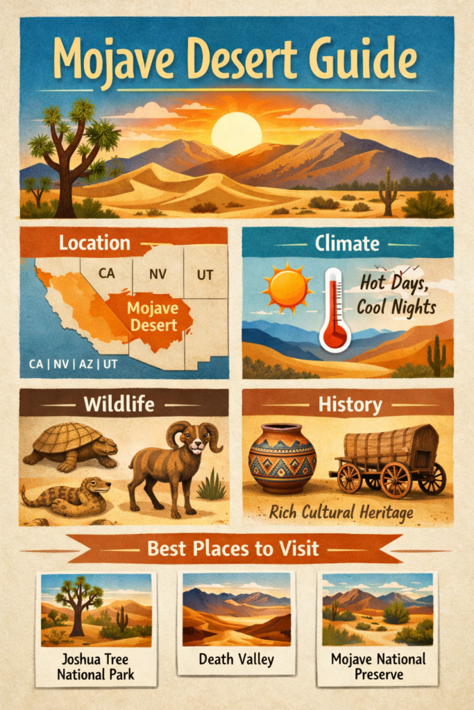
Mojave Desert at a Glance
| Fact | Detail |
| Main location | Southeastern California, southern Nevada, and smaller parts of Arizona and Utah |
| Size | Varies by definition; different sources use different boundaries |
| Climate | Desert climate with low precipitation and wide temperature swings |
| Signature plant | Joshua tree |
| Signature animals | Desert tortoise, kangaroo rat, sidewinder rattlesnake, bighorn sheep |
| Best travel season | Cooler months, especially fall through spring |
| Famous places | Mojave National Preserve, Joshua Tree National Park, Death Valley National Park |
This quick snapshot gives you the basic frame. But the Mojave becomes much more interesting once you start looking at its terrain, its elevation zones, its ecology, and its story of human presence.
Mojave Desert Map and Location
Understanding the Mojave Desert map begins with one important idea: the desert is better understood as a transition zone than as a hard-edged block. It sits between major desert systems and mountain systems, which means it connects to other regions rather than existing in isolation. To the north, it blends toward the Great Basin. To the south and southeast, it transitions toward the Sonoran Desert. That overlap is one reason different maps may show slightly different outlines.
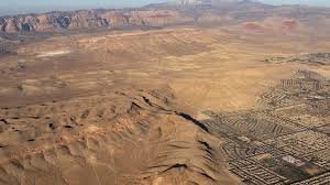
In practical terms, the Mojave occupies a large portion of the American Southwest. It is best known for southeastern California and southern Nevada, but its influence extends farther in ecological and geographic terms. The landscape includes valleys, mountain fronts, rocky uplands, dune fields, dry lake beds, and basin-and-range formations. It is not one uniform surface. It is a patchwork of environments linked by arid conditions and elevation change.
Elevation plays a huge role in how the Mojave looks and feels. Lower basins are hotter and more exposed. Higher slopes can be cooler and support different plant communities. That means the desert changes quickly as you move across it. A short drive can take you from broad open valleys into higher woodlands, from sandy flats into stone ridges, or from scorching dry basins into surprisingly cool mountain corridors.
This is also why the Mojave is so rich for travelers, photographers, and hikers. A map of the Mojave is not only a navigation tool. It is a guide to shifting ecosystems. When you understand the geography, the desert stops looking like a blank expanse and starts looking like a living system with layers of meaning.
Geography and Landscape Features
The Mojave Desert geography is one of the most compelling parts of the region because it is so varied. The stereotype of a flat, sandy desert does not fit the Mojave very well. Instead, the land features basins, mountain chains, mesas, dry washes, cinder cones, lava fields, rock outcrops, salt flats, and dune systems. This variety creates a dramatic and constantly changing visual experience.
One of the most recognizable landforms is the dune field. Dunes reveal the power of wind in a desert environment. They show that even in a dry landscape, sediment is always being transported, deposited, and reshaped. In the Mojave, dunes are not simply scenic backdrops. They are active geological features that tell a story about weather, erosion, and time.
Salt flats and dry lake beds are equally important. These flat white or pale surfaces mark places where water once gathered in shallow basins, then evaporated over time. The minerals left behind create a harsh and often dazzling landscape. These spaces help explain the hydrology of the Mojave. Even though the desert is dry now, water has shaped it deeply over long periods.
Volcanic features add another layer to the desert’s character. Cinder cones, lava flows, and ancient volcanic deposits show that the Mojave was shaped not only by wind and water but also by fire from within the earth. These features are powerful because they remind us that the desert is a geologically active story, not a frozen one. The land continues to reveal evidence of old eruptions, uplift, faulting, and erosion.
The basin-and-range structure is another central feature. This means the desert consists of alternating valleys and mountain ranges. These changes in height affect Temperature, drainage, soil type, and vegetation. A higher ridge may support one kind of plant community, while a lower basin supports another. That spatial variation is one reason the Mojave contains so many microhabitats.
Mojave Desert Climate and Weather Patterns
The Mojave Desert climate is often described simply as hot and dry, but that description is too narrow. The real climate of the region is one of contrast and fluctuation. Heat, cold, drought, wind, rare rainfall, seasonal change, and elevation differences all shape the way life survives here.
The most obvious feature is low precipitation. Rain is limited, irregular, and unevenly distributed across the region. Some areas receive more moisture because they are higher in elevation, while lower basins may remain extremely dry. That means the desert is not equally arid everywhere. Instead, it contains a gradient of dryness that changes from place to place.
Temperature variation is just as important. Daytime heat can be intense, especially in summer, but nights may cool sharply. In higher locations, winter can bring frost or even snow. This sharp shift between day and night, and between summer and winter, creates a demanding environment for plants and animals. Species that live here must be highly specialized, efficient, and resilient.
The desert’s weather also depends on location within the region. A lower valley may feel much more severe than a higher plateau. A shaded slope may be cooler than an exposed basin. A mountain area may capture a little more precipitation and support different vegetation. Because of this, the Mojave is best understood as a climate mosaic rather than a single condition.
Mojave Desert Plants and Flora
The Mojave Desert plants’ story is really a story of adaptation. Every plant species here has to solve the same basic problem: how to survive with limited water, intense sunlight, difficult soils, and temperature stress. The result is a plant community that is elegant, efficient, and surprisingly diverse.
The most famous plant in the region is the Joshua tree. It is the strongest visual symbol of the Mojave and one of its most important ecological indicators. When you see a Joshua tree, you are likely in a Mojave habitat. The plant is not a true tree in the botanical sense, but a yucca species that has become deeply associated with the desert’s identity. Its branching form, spiky leaves, and unusual silhouette make it instantly recognizable.
The Joshua tree is important not only because it is iconic, but also because it marks the environmental conditions of the region. It grows in specific elevation ranges and climate zones. That means its presence tells you something about the land itself. In that sense, the Joshua tree is both a symbol and a biological signal.
But the Mojave flora is far richer than one famous species. Creosote bush is one of the most widespread plants in the desert and is known for its resilience. Mojave yucca, blackbrush, desert scrub, pinyon pine, juniper, cacti, and seasonal wildflowers all contribute to the ecological texture of the landscape. Near springs, riparian plants appear and create small pockets of greener life.
Mojave Desert Wildlife and Animals
The Mojave Desert wildlife is far richer than many people expect. The region supports a wide variety of mammals, birds, reptiles, amphibians, insects, and arachnids. What makes this possible is not the abundance of water but the diversity of habitat. The desert contains dunes, valleys, slopes, washes, rocky areas, and riparian pockets, each of which supports different forms of life.
One of the most famous animals is the desert tortoise. It is a key symbol of Mojave conservation and a species strongly tied to habitat health. Its presence tells us something important about the condition of the ecosystem. Because the tortoise depends on stable habitat and specific environmental conditions, it is highly vulnerable to disturbance, fire, and fragmentation.
Other notable Mojave animals include kangaroo rats, sidewinder rattlesnakes, bighorn sheep, coyotes, foxes, bats, jackrabbits, lizards, and birds of prey. Each species has its own method of managing heat, conserving water, avoiding predators, and finding food in a dry and difficult world. Many burrow underground. Some are active at dawn or dusk. A few of us rely on camouflage. Some travel long distances to find resources.
Nocturnal behavior is especially common in the Mojave. Many animals avoid the midday heat by becoming active at night or during the coolest parts of the day. This is one of the most important survival patterns in the desert. It helps explain why the landscape may appear silent or empty in the afternoon, but alive with motion at sunrise, sunset, and nighttime.
Mojave Desert History and Indigenous Cultures
The Mojave Desert’s history reaches far beyond modern roads, national parks, and travel guides. It is a region shaped by thousands of years of human presence. Long before the area became a destination for tourists and road-trippers, it was home, route, resource, and homeland for Indigenous communities.
The desert takes its name from the Mojave people, which is a reminder that the region’s identity is tied directly to Native history and culture. This is not a decorative detail. It is central to understanding the desert as a living place with human meaning. The land was never blank. It was known, used, traveled, and cared for by the people who lived there.
Indigenous trail networks were especially important. These routes connected water sources, seasonal camps, trade corridors, and community locations across a demanding landscape. In a desert environment, knowing where water was available could mean the difference between survival and failure. Native travelers developed deep knowledge of the terrain and used it to move safely and efficiently across long distances.
This history shaped later routes as well. One of the most important examples is the Mojave Road, which reflects older Indigenous pathways and later settler infrastructure. What may appear today as a historic route for recreation and tourism was once part of a much older network of movement and survival. That means the road is not just a transport corridor. It is a cultural archive.
European contact and later American expansion changed the region dramatically. Exploration, military activity, railroads, settlement, reservation systems, and boarding schools all affected Indigenous peoples in the Mojave. These are difficult parts of history, but they need to be acknowledged. A meaningful guide should not reduce the desert to scenery alone. It should also recognize the impacts of colonization and the endurance of Native communities.
Mojave Desert Geology and Landforms
The Mojave Desert geology is one of the most visually exciting aspects of the region because it reveals a landscape built by multiple forces over immense periods of time. Uplift, faulting, erosion, sediment movement, volcanic activity, and climate have all helped shape the terrain.
The basin-and-range structure is especially important. This pattern creates alternating low valleys and high mountain ranges. The effect is dramatic because it changes how the desert functions. Water flows differently, soil develops differently, temperature shifts differently, and plant communities change differently. The geology becomes a map of ecological possibility.
Volcanic landforms add another striking dimension. Cinder cones, lava flows, domes, and rough basaltic surfaces show that the desert was shaped by eruptions and cooling rock in the distant past. These features are not only scientifically interesting. They also give the landscape a raw, textured look that makes it visually unforgettable.
Dunes are another major geological attraction. They are shaped by persistent wind and by the supply of loose sediment. Their curves and ridges change over time, sometimes subtly and sometimes dramatically. Standing near dunes can feel like standing at the edge of a moving natural sculpture.
Dry lake beds and salt flats tell a different story. They indicate where water once accumulated and later evaporated. The minerals left behind create pale, flat surfaces that can seem almost lunar. These areas are important because they show the desert’s long hydrological history. The Mojave may be dry now, but it was shaped by water for ages.
The Rocky Mountains and exposed cliffs also contribute to the landscape. They create shelter, shade, elevation differences, and travel corridors for animals and humans. They also reveal layers of earth history that are otherwise hidden beneath the desert surface.
Best Places to Visit in the Mojave Desert
If you are building out Mojave Desert travel guide content, the best places to visit are the sites that combine scenery, access, history, and ecological value. The Mojave is large, so the ideal destination depends on what kind of experience you want. Some places are famous for iconic views. Others are better for hiking, stargazing, photography, learning, or quiet reflection.
Mojave National Preserve is one of the strongest places to start. It offers dunes, volcanic terrain, Joshua tree woodland, historic trails, and huge open desert spaces. It is a place where travelers can see the Mojave in a highly concentrated form. The preserve also helps visitors understand how multiple habitat types exist in one protected region.
Travel Tips for Visiting the Mojave Desert Safely
A practical Mojave Desert travel guide must include safety, because the desert can be unforgiving if you are unprepared. The first rule is simple: bring more water than you think you will need. Even a short walk can become risky if the heat is stronger than expected. Dehydration can happen fast, and rescue may be far away.
Timing is another major factor. The most comfortable season for visiting is generally the cooler part of the year, especially from fall through spring. Summer heat can be severe, especially at lower elevations. Early morning and late afternoon are often the best times for outdoor activity because temperatures are lower and the light is better for photography.
Route planning is crucial. Some roads are well-maintained and easy to travel. Others are remote, rough, or isolated from services. Never assume that cell service will be strong everywhere. Tell someone your route, check the current road conditions, and know how much fuel you have before heading into more remote areas.
Clothing and equipment matter too. Sun protection, sturdy shoes, backup water, snacks, a map, and a basic emergency kit can make a huge difference. In a desert environment, small preparation habits have large benefits.
Travel pace also matters. The Mojave is not a place for rushed sightseeing. It is better to visit fewer places and experience them properly than to try to cover everything too quickly. The desert rewards calm attention. If you slow down, you are more likely to notice birds, tracks, rocks, plants, and changing light.
For many visitors, the best memory is not the fastest route or the longest checklist. It is the feeling of space, quiet, and scale. That is part of what makes the Mojave so special.
Conservation Issues and Environmental Challenges
No modern Mojave Desert guide is complete without conservation, because the region is under serious pressure. The desert may look timeless, but it is affected by climate change, invasive species, wildfire, water stress, and habitat disruption.
One of the biggest issues is changing fire patterns. Invasive grasses can spread across parts of the desert and create fuel where little fuel existed before. That increases fire risk in places that evolved under very different conditions. This is especially dangerous for slow-growing species like Joshua trees, which are not adapted to frequent burns.
Joshua tree loss is a major concern. Large wildfires have destroyed huge numbers of trees in some areas, and recovery is slow. Because these plants grow and reproduce slowly, repeated fire can do long-term damage. Their decline is not only an ecological problem. It is also a cultural and visual loss, because the Joshua tree is one of the region’s defining symbols.
Interesting Facts About the Mojave Desert
The Mojave is often described as the smallest of the major North American deserts, but that label can be misleading. “Small” does not mean simple. In fact, the desert is remarkably complex, with a broad range of elevations, landforms, and habitat types. It is one of the most biologically and geographically interesting desert systems in the United States.
Joshua trees are more than a scenic symbol. They are also an indicator species. That means their presence helps signal that a location belongs to the Mojave ecological zone. This makes them useful not only for visitors but also for scientists and conservation planners.
The desert contains many protected and historically important landscapes. National parks, national preserves, wilderness areas, and cultural sites all reflect their value. The Mojave is not just a place to pass through. It is a place people study, protect, and experience deeply.
Another interesting fact is that the desert looks different depending on the kind of boundary you use. Some maps are based on climate. Others use vegetation or ecoregion data. That means the Mojave is best viewed as a living region with shifting edges rather than a perfectly fixed shape.
The desert is also richer in life than people expect. Large numbers of mammals, birds, reptiles, and plants thrive here by adapting to the environment. The idea of a lifeless desert is simply inaccurate. The Mojave is a place of hidden abundance, especially when viewed with patience and ecological awareness.
FAQs
1. Where is the Mojave Desert located?
The Mojave Desert is in the southwestern United States, mainly in southeastern California and southern Nevada, with smaller parts in Arizona and Utah. Different sources draw the edges a little differently, but they all place it between major desert and mountain systems in the region.
2. What is the Mojave Desert best known for?
It is best known for the Joshua tree, Death Valley, wide basins, salt flats, dunes, mountains, volcanic landforms, and a deep Indigenous history. It is also known for its strong conservation value and its mix of travel, science, and culture.
3. What animals live in the Mojave Desert?
The Mojave supports desert tortoises, kangaroo rats, sidewinder rattlesnakes, bighorn sheep, foxes, coyotes, bats, jackrabbits, birds of prey, reptiles, and many insects. NPS says Mojave National Preserve alone supports over 50 mammal species and over 200 bird species.
4. When is the best time to visit the Mojave Desert?
The best time to visit is usually during the cooler months, especially from fall through spring. Summer can be very hot in low-elevation places, so travelers should plan carefully, carry extra water, and avoid risky conditions.
5. Is the Mojave Desert dangerous to visit?
It can be dangerous if you are not prepared, mainly because of heat, distance, rough roads, and limited water. But with good planning, it is very manageable and rewarding. Route planning, water, and checking current conditions are essential.
Conclusion
The Mojave Desert is a place of contrast, resilience, and lasting beauty. It is harsh but alive, remote but meaningful, and ancient yet still changing. Its plants, animals, landforms, and history make it one of the most fascinating desert regions in the world.


