Introduction
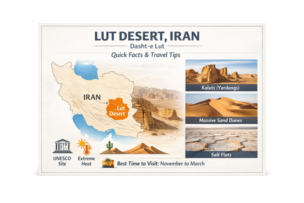
The Lut Desert, also called Dasht-e Lut, is one of Iran’s most dramatic natural wonders. Known for extreme heat, vast dunes, wind-carved landforms, and UNESCO World Heritage status, it is a desert of striking beauty and scientific importance.
Quick Overview
| Key detail | What you should know |
| Main name | Lut Desert |
| Persian name | Dasht-e Lut |
| Location | Southeast Iran |
| UNESCO status | World Heritage Site, inscribed in 2016 |
| Famous landform | Kaluts / yardangs |
| Climate | Hyper-arid, extremely hot, windy |
| Best travel season | Cooler months, especially late autumn to early spring |
| Why it matters | Outstanding scenery, geology, and desert processes |
UNESCO states that the property covers 2,278,015 hectares, with a buffer zone of 1,794,134 hectares. It also explains that the desert lies in a rain-shadow basin surrounded by mountains, which helps create its extreme dryness and the unusual character of its landscapes.
What Does Lut Mean?
In Persian, the word “Lut” refers to bare land that has no water and very little or no vegetation. UNESCO uses this meaning clearly, and it suits the desert perfectly. The name is more than a label; it is a description of the place itself. It suggests dryness, exposure, scarcity, and the difficulty of survival in a landscape where moisture is rare and plant life is limited.
That meaning gives the desert a strong identity, especially for readers who first encounter the name and wonder what it represents. The Lut Desert is famous not only because it looks impressive, but because its name captures the essence of the place. It is land stripped down to its most severe conditions. Water is scarce, greenery is minimal, and the environment is shaped by pressure, evaporation, and wind.
Why the name matters in travel content
When people search for Dasht-e Lut, they are often trying to understand more than just a location. They want to know why this desert is so well known, why it has become a global talking point, and whether it is really as extreme as travelers and scientists say. The answer is yes, and the name itself already hints at that reality.
A strong article on the Lut Desert should therefore do more than list facts. It should explain the meaning behind the name in a simple, human way. The identity of the desert is built around absence: absence of water, absence of dense vegetation, and absence of comfortable conditions. That is exactly what makes it unforgettable.
Where is the Lut Desert Located?
The Lut Desert is located in southeast Iran. Britannica describes it as a desert in eastern Iran extending roughly 320 kilometers from northwest to southeast and about 160 kilometers wide. UNESCO similarly places it in southeast Iran and explains that it lies in a mountain-surrounded interior basin.
This geographic setting is one of the main reasons the desert is so dry. The surrounding mountains block much of the incoming moisture, leaving the basin in a rain-shadow environment. Over time, this has produced a hyper-arid climate, extremely high evaporation, salt accumulation, wind-shaped landforms, and a wide variety of desert surfaces.
Geography in simple words
A useful way to imagine the Lut Desert is as a huge dry bowl in southeastern Iran. The mountains around it act like a wall, limiting the amount of rain that can enter the basin. As a result, water is scarce, and evaporation is intense. Winds then continue to reshape the surface, moving sand, stripping away loose material, and carving the Dramatic ridges and corridors that make the desert look almost otherworldly.
The location also matters for travel. Because the desert is remote and expansive, reaching its most spectacular areas requires planning, transportation, and awareness of local conditions. It is not the kind of place you simply pass through casually. Its geography is part of its power and part of its challenge.
Whyis thes Lut Desert Famous?
The Lut Desert is famous for several major reasons. First, it is known for its extreme heat, with NASA reporting some of the highest land-surface temperatures ever detected by satellite in the region. Second, it is famous for its extraordinary landforms, especially the giant wind-carved ridges known as kaluts or yardangs. Third, it is internationally recognized because UNESCO inscribed it as a World Heritage Site.
UNESCO describes the Lut as a globally important hot-desert landscape, while NASA has highlighted it as one of the hottest places on Earth in terms of land-surface temperature. Together, these descriptions help explain why the desert stands out in both scientific discussions and travel writing.
It is also famous because it is not a single-type desert. Some deserts are mostly sand. Others are mostly rock. The Lut Desert contains a mixture of huge dunes, rock pavements, salt features, dry basins, and wind-shaped ridges. That combination gives it visual depth and geological variety.
Why travelers remember it
Many deserts can appear similar at first glance, especially to someone who has never spent time in one. The Lut Desert is different. Its massive ridges, open basins, stony flats, and towering dunes create a landscape that feels layered and varied. It is not just space; it is a whole desert ecosystem of forms and textures. That is one of the reasons it leaves such a strong impression on visitors.
Lut Desert Location and Geography
The Lut Desert is more than a single scenic site. It is a very broad desert system with distinct zones and landform patterns. Britannica explains that the eastern side contains a major dune massif, while the western side features elevated ridges separated by corridors shaped by wind. That contrast creates one of the desert’s most memorable visual effects.
UNESCO also notes that the western portion is dominated by yardang fields, while the eastern side contains a major sand sea. In addition, the property includes extensive stony deserts, salt pans, and broad dune systems. In other words, the Lut is not one uniform surface. It is a highly varied desert landscape where rock, sand, salt, and open flats exist together in one enormous natural setting.
Main geographic zones
| Zone | Main surface type | What it looks like |
| West | Yardangs / kaluts | Long ridges and narrow corridors |
| East and south | Sand seas | Huge dunes and sandy expanses |
| Flat areas | Desert pavement/hamada | Stony, dark, barren ground |
| Low basins | Salt pans/playa | White crusts and evaporite surfaces |
UNESCO states that the property also includes basaltic surfaces, pediplains, salt pans, and wide dune systems. Some of the dunes are enormous, with heights reaching up to 475 meters, placing them among the tallest recorded dunes on Earth. That scale alone helps show how exceptional the Lut Desert really is.
What Makes Lut Desert a UNESCO World Heritage Site?
The Lut Desert was inscribed on the UNESCO World Heritage List in 2016 under criteria (vii) and (viii). Criterion (vii) refers to outstanding natural beauty, while criterion (viii) relates to exceptional geological processes and earth history. UNESCO recognized the site for both its visual splendor and its scientific importance.
UNESCO describes the desert as a remarkable example of ongoing geological activity in a hot desert environment. The yardang fields, dune seas, salt features, and erosion patterns demonstrate how wind and dry conditions continue to shape the land in real time.
UNESCO significance in simple English
The UNESCO label does not mean only that the place is pretty. It means the Lut Desert has global importance. It is valuable because it reveals how deserts form, how wind sculpts terrain, how minerals accumulate through evaporation, and how extreme environments evolve. That combination of beauty and scientific value is what makes the desert special on a world scale.
For travelers, the UNESCO designation adds another layer of meaning. It tells you that the place is not just a travel destination. It is part of the planet’s natural heritage, something rare, fragile, and worth understanding carefully.
Climate and Weather Patterns
The Lut Desert has a hyper-arid climate, which means it is far drier than most places people are used to. UNESCO explains that the region sits in a rain-shadow basin surrounded by mountains, and this geography greatly reduces rainfall. Strong winds, especially those active from June to October, also play a major role in shaping the desert’s surface and increasing erosion.
These winds are not a minor weather detail. They are one of the most important natural forces in the region. UNESCO notes that they move large volumes of sediment across the landscape, while NASA explains that they help carve bedrock into long corrugated ridges known as yardangs.
NASA’s research has also shown that the Lut Desert can reach extraordinary land-surface temperatures. One study reported a reading of 80.8°C, while earlier work recorded 70.7°C in the region. It is important to understand that these are surface temperatures, not air temperatures, but they still show just how intense the desert heat can be.
What this means for visitors
The climate makes timing extremely important. The Lut Desert is best visited during the cooler season, because summer conditions can be severe and dangerous for casual travelers. Even though the scenery is calm and silent, the environment itself is harsh and demanding. Anyone planning a visit should treat it as a serious desert journey, not a simple sightseeing stop.
For comfort, safety, and photography, the cooler months are the most suitable period. During that time, the heat is more manageable, the air is more bearable, and the desert becomes far more accessible.
Landforms of the Lut Desert
The Lut Desert is especially famous because it contains so many different landforms in one large area. UNESCO says the site includes some of the finest examples of aeolian yardangs in the world, along with extensive desert pavement, dune fields, salt pans, and evaporite features. This diversity is unusual and makes the landscape both visually compelling and scientifically valuable.
1) Kaluts / Yardangs
The most iconic feature of the Lut Desert is the kalut. These are large wind-carved ridges and corridors formed by erosion over long periods. UNESCO says they are massive corrugated structures shaped by sand-laden winds. Some are up to 155 meters high, and their ridges can extend for more than 40 kilometers.
NASA also highlights these formations, explaining that strong winds, particularly from the northwest, continue to carve the bedrock each year. The result is a spectacular terrain of parallel ridges, narrow gaps, and broad erosion corridors. From a distance, the area can look almost like a ruined stone city built by nature itself.
These formations are not only visually iconic. They are also important because they reveal how persistent wind erosion can sculpt rock into dramatic and highly organized shapes. That is why the kaluts are often the first image that comes to mind when people think of the Lut Desert.
2) Sand seas and dunes
The desert also includes enormous sand seas. UNESCO says these dune fields cover large sections of the property and include active dunes that reach up to 475 meters in height. The dunes appear in several shapes, including linear, crescent-shaped, star-shaped, and funnel-shaped forms. That variety makes the Lut an important natural site for studying how wind builds and reshapes sand landscapes.
NASA notes that many of the dunes in the eastern and southern parts of the desert are rust-colored and highly prominent. These dunes are not just picturesque. They are evidence of wind transport, sediment sorting, and long-term landscape construction.
For photographers and travelers, the dunes provide a sense of scale and softness that contrasts beautifully with the harder, more angular rock formations elsewhere in the desert.
3) Stony desert pavements
Another major feature is the hamada, or desert pavement. UNESCO describes these areas as stony surfaces covered with wind-polished fragments and coarse material. They are widely distributed throughout the desert and contribute to the variety of terrain.
These stony zones are important because they prove the Lut Desert is not just about sand. It is a mixed desert system. Some areas are rocky, some are sandy, some are salty, and some are shaped by a combination of all three. This diversity creates a more complex and interesting landscape than many people expect.
4) Salt flats and evaporite landforms
The Lut Desert also includes salt pans, salt crusts, crystal deposits, salt polygons, tepee-like fractured crusts, salt pingos, salt karren, and gypsum domes. UNESCO explains that many of these features form when dissolved minerals from incoming water evaporate and leave behind crusts or other mineral accumulations.
These white and cracked surfaces create a striking contrast with the darker stony pavements and the golden or red dunes. They also give the desert a strange, almost lunar appearance in some places. This is part of what makes the Lut Desert feel so unique and unforgettable.
Landform table
| Landform | Simple description | Why it matters |
| Kaluts | Wind-carved ridges and corridors | Signature feature of the desert |
| Dune seas | Huge fields of moving sand | Show major wind deposition |
| Hamada | Stony desert pavement | Adds variety and texture |
| Salt pans | Flat salty basins | Reveal evaporation and mineral buildup |
| Evaporite crusts | White or cracked salt surfaces | Show how water and minerals behave in a desert |
UNESCO describes the kalut and yardang formations as among the best expressed in the world in terms of size, continuity, and height. That is a powerful statement, and it is one of the clearest reasons the Lut Desert has earned worldwide fame.
Flora and Fauna in the Lut Desert
Some people assume the Lut Desert contains no life at all, but that is too simple. UNESCO explains that the site does have flora and fauna adapted to severe conditions, including a notable adapted insect fauna. The truth is that the ecosystem is sparse and specialized rather than abundant and lush.
That means you should not expect dense vegetation, green fields, or large numbers of animals. Instead, life in the Lut Desert exists in very limited and highly adapted forms. Organisms here survive because they have evolved to handle heat, dryness, and nutrient scarcity.
What kind of life exists?
UNESCO does not provide a full species catalog on the main site description, but it does note that the region supports desert-adapted plants, animals, and insects. It also suggests that further biological study would help deepen knowledge of the ecosystem.
The most important point is that the desert is not lifeless. It is life-sparse. That distinction matters because it helps readers understand how nature functions in extreme environments. Even the harshest places on Earth can support fragile ecological systems, provided the organisms are suited to them.
A simple truth about desert ecology
The Lut Desert is not a place of abundance; it is a place of adaptation. The plants and animals that live there must cope with extreme heat, very little water, and a difficult landscape. That makes the environment ecologically interesting even if it appears empty to the casual observer.
Human History and Culture Around the Lut Desert
Although the interior of the Lut Desert has always been extremely difficult to inhabit, the surrounding areas have a long human history. UNESCO states that the wider region shows evidence of habitation going back 7,000 years, though settlement has generally remained around the edges rather than in the desert core.
This makes sense. The central desert is too harsh for most permanent habitation, but the margins have long supported human life, movement, and adaptation. Communities along the borders of the desert have had to deal with water scarcity, heat, and the need to live in harmony with a demanding environment.
UNESCO also notes that Shahdad sits in the buffer zone and that villages are mainly located on the western edge. This detail is important because it shows how people have historically found ways to live near the desert without trying to conquer its interior.
Why this history matters
A strong article on the Lut Desert should not treat the site as if it were a blank, lifeless natural space. It is tied to human settlement, survival, and land use at the edges of an extremely harsh basin. That historical dimension adds depth to the landscape and helps readers understand the desert as part of a larger regional story.
Why the Lut Desert Is So Important Scientifically
The Lut Desert serves as a natural laboratory for studying wind erosion, sand movement, salt processes, and desert landform development. UNESCO emphasizes that it is an exceptional example of ongoing geological processes in a hot desert, especially those related to erosion and deposition.
NASA’s satellite observations have also made the desert important in remote sensing and climate studies. Researchers use the region to examine surface heating, terrain patterns, and seasonal changes. The Lut Desert, therefore,e matters not just to geographers and travelers, but also to earth scientists and climate researchers.
Why geographers love it
The value of the Lut Desert lies partly in the sheer number of landforms packed into one area. It is rare to find such a broad combination of yardangs, dune seas, stony pavements, salt features, and open basins in one place. That diversity makes it a powerful site for studying how different desert processes interact.
It is also a place where large-scale erosion is easy to observe. Wind has visibly shaped the land over long periods, leaving behind forms that are both beautiful and highly instructive. This makes the Lut Desert a kind of open-air textbook for desert geomorphology.
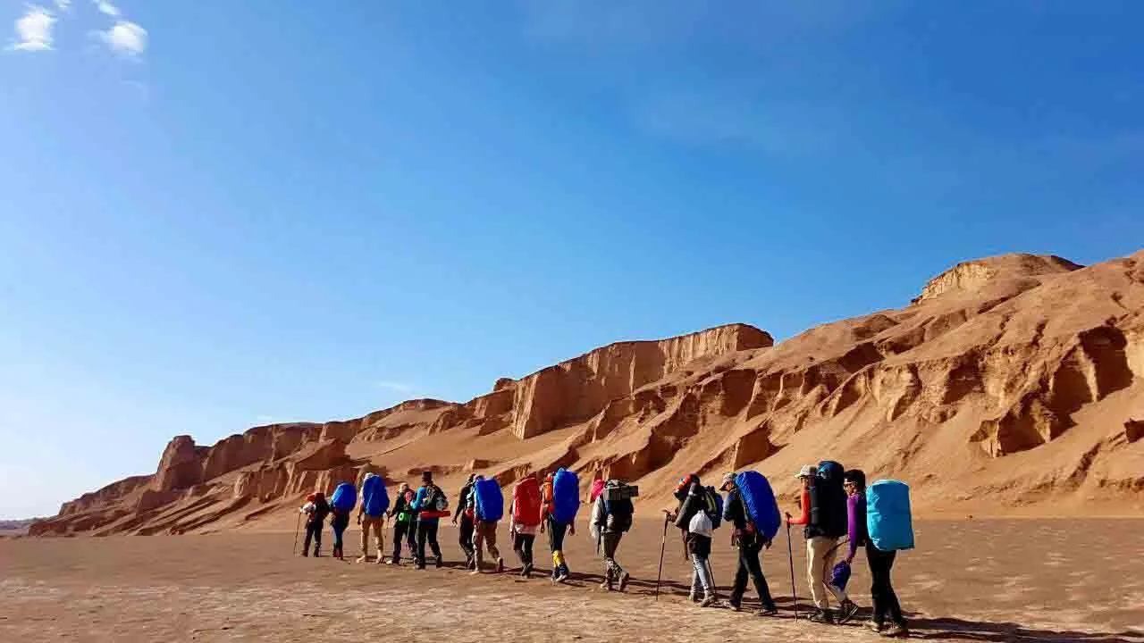
Travel Guide: How to Visit the Lut Desert
The Lut Desert is not an ordinary urban destination or a casual sightseeing stop. UNESCO states clearly that much of the area is inaccessible because of remoteness, lack of water, and extreme heat. That means a trip to the desert should be planned carefully, with the mindset of a desert expedition rather than a day trip.
In practical terms, many travelers use Kerman as a main base and Shahdad as the usual gateway to the Kaluts area. From there, visitors often continue by road, sometimes with local guide support or 4×4 transport, especially when heading deeper into remote desert zones.
Practical access snapshot
| Travel point | Practical note |
| Main base | Kerman |
| Common gateway | Shahdad |
| Best transport | Overland travel, often with a local guide |
| Desert exploration | Often done with 4×4 support in remote areas |
Because the terrain is remote and the environment is severe, many travel sources recommend going with someone experienced in desert travel. That advice is sensible. The Lut Desert rewards preparation, caution, and good timing.
Best Time to Visit the Lut Desert
The best time to visit the Lut Desert is during the cooler season. Travel guidance commonly points to late autumn through early spring, with November to March often mentioned as the most suitable window. Some travel sources narrow the comfortable period further to November and December, while others also recommend March and early April.
This makes sense because the summer heat is intense, and the winds between June and October can be strong. The cooler months are safer, more comfortable, and more suitable for walking, photography, and camping.
Best months by purpose
| Purpose | Best timing |
| General sightseeing | November to March |
| Photography | Early morning or sunset in cool months |
| Camping | Winter or late autumn |
| Comfort | December and January are often best |
The simplest rule is to go when the heat is lower and the nights are manageable. The desert will still be harsh, but the experience becomes much more enjoyable and much safer.
Travel Tips for the Lut Desert
The Lut Desert rewards careful planning. Because UNESCO highlights the area’s remoteness, extreme heat, and lack of water, visitors should prepare for a serious desert environment. That means bringing more water than seems necessary, protecting yourself from the sun, and avoiding unnecessary risk.
Simple travel tips
Carry enough water for the full trip, and ideally more than one person expects to use. Wear sun protection, including a hat, sunglasses, and sunscreen. Bring layered clothing, because desert nights can become cold even after hot daytime temperatures. Travel with a local guide, especially if you plan to go beyond the most accessible points.
Do not wander far from the planned route. Desert terrain can be deceptive. A flat and empty surface can look simple, but the ground can change quickly, and heat, distance, and lack of shade can turn a small mistake into a serious problem.
What to pack
- Water and extra water
- Light, breathable clothing
- Warm layer for night
- Hat and sunglasses
- Sunscreen
- Snacks
- First-aid kit
- Power bank
- Good shoes for sand and stone
These are basic desert essentials, but in the Lut Desert, they are especially important because the environment is remote, dry, and unforgiving.
Top Things to See in the Lut Desert
The most famous thing to see in the Lut Desert is the Kaluts. UNESCO says these yardangs are among the best examples in the world, and they remain the visual symbol most closely associated with the desert.
The next major attraction is the dune sea. UNESCO and NASA both emphasize the size and variety of the dunes, including some of the tallest dunes on Earth. For many visitors, the dunes are as unforgettable as the ridges.
Other things worth seeing
You can also look for stony plains, salt crusts, dry channels, and the transition between dark rocky surfaces and pale salty flats. These changes in color, texture, and shape are part of what makes the Lut Desert so photogenic.
A simple visitor’s bucket list
- Sunrise or sunset over the Kaluts
- A walk near the dune fields
- A look at salt crusts and flat desert basins
- Night sky viewing away from city lights
- A guided desert drive from Shahdad or nearby access areas
Photography and Stargazing in the Lut Desert
The Lut Desert is a fantastic destination for photography because the shapes are bold, the shadows are dramatic, and the scenery changes greatly with the light. UNESCO even describes the site as a visually stunning mosaic of desert colors and landforms, with broad open views that emphasize scale.
The best light usually comes in the early morning and late evening. At those times, the ridges appear deeper, the dunes look smoother, and the whole desert takes on a more cinematic character. This is especially true in the Kaluts area, where long shadows can make the landforms stand out with remarkable clarity.
Stargazing is another major appeal. Because the desert is remote and far from dense urban lighting, the night sky can feel vast and bright on a clear night. For many travelers, the quiet of the desert after sunset is one of the most memorable parts of the journey.
Interesting Facts About the Lut Desert
The Lut Desert is among the hottest places on Earth in terms of land-surface temperature. NASA has reported a record reading of 80.8°C, while UNESCO has documented a temperature of 70.7°C within the property. These are surface temperatures rather than air temperatures, but they still demonstrate how extreme the environment can be.
Some of the desert’s yardangs are up to 155 meters high and can be traced for more than 40 kilometers. That scale helps explain why the landscape looks so vast and unusual.
The dune systems are equally impressive. UNESCO says some dunes rise to 475 meters, placing them among the largest dunes recorded anywhere on Earth. That alone makes the Lut Desert a major reference point in world desert geography.
Another important fact is that the wider region has evidence of human habitation stretching back 7,000 years, although permanent settlement has always remained mostly around the margins. This gives the area both a natural and a cultural story.
Environmental Issues and Conservation
Even a huge desert requires protection. UNESCO says the Lut Desert is partly safeguarded by its remoteness and severe conditions, but it still needs active management. The organization also notes that more detailed biodiversity research would help improve long-term conservation planning.
UNESCO identifies several bodies involved in oversight, including the Forests, Range and Watershed Management Organization, the Iranian Department of Environment, and the Iran Cultural Heritage, Handicrafts and Tourism Organization. That arrangement reflects the fact that geology, ecology, tourism, and land management all overlap in the desert.
Why conservation matters
The Lut Desert may feel endless, but it is still vulnerable. Salt crusts can be damaged, vehicle tracks can scar the surface, and delicate desert margins can be disturbed by human activity. Responsible tourism matters because the site’s very features depend on natural processes that are slow and fragile.
Protecting the Lut Desert means respecting the landscape, staying on approved routes, and recognizing that even severe environments can be harmed by careless use.
Pros and Cons
Pros
The Lut Desert offers world-class scenery, especially in the Kaluts, dune fields, and salt flats. Its UNESCO World Heritage status adds major natural-historical value, and the cooler season can make the journey deeply rewarding for photographers, desert travelers, and nature lovers.
It is also an excellent place to see geology in action. You do not need to be a scientist to notice how wind, sand, heat, and salt have shaped the terrain. That makes the desert both educational and inspiring.
Cons
The desert is extremely hot, very dry, and highly remote. That means it is not a place for careless travel or last-minute decisions. UNESCO clearly notes the lack of water and difficult access, both of which should be taken seriously.
The ecological system is fragile, too. Life exists there, but it is limited and adapted to harsh conditions. Visitors need to travel respectfully so the landscape stays protected for future generations.
FAQs
NASA says the Lut Desert has ranked among the hottest surfaces on Earth in satellite studies, and UNESCO records a land-surface temperature of 70.7°C within the property. These are land-surface temperatures, not air temperatures, but they show how extreme the desert can be.
The most famous feature is the Kaluts, the giant wind-carved yardangs. UNESCO says they are among the best examples in the world and that some are up to 155 meters high.
The best time is usually during the cooler season, especially November to March. Travel sources often recommend late autumn, winter, and early spring because the desert becomes dangerously hot in summer.
Travel sources commonly use Kerman as the main base and Shahdad as the usual access point for the Kaluts area. From there, travelers often continue by road and may use guided desert transport for deeper exploration.
UNESCO inscribed it in 2016 because of its exceptional beauty and outstanding geological processes. The site is important for its yardangs, dune fields, salt features, and the ongoing wind-driven shaping of the desert landscape.
Yes, but life is limited and highly specialized. UNESCO says the property has flora and fauna adapted to harsh conditions, including adapted insect fauna, although biological knowledge of the site is still incomplete.
Conclusion
The Lut Desert is more than a harsh desert landscape. It is a world-famous natural site shaped by wind, heat, and time, offering rare scenery, rich geological value, and an unforgettable travel experience.


