Introduction
The Taklamakan Desert is one of the harshest places on Earth, and its nickname, “Sea of Death,” reflects just how dangerous and difficult it is to cross. Located in Xinjiang, western China, this vast desert is known for shifting dunes, severe dryness, dust storms, and a long history of challenging travelers. Its deadly reputation comes from real geography, extreme climate, and centuries of survival risk.
Quick Answer: Why Is the Taklamakan Desert Called the Sea of Death?
The Taklamakan Desert is called the Sea of Death because it is enormous, arid, storm-prone, and extremely difficult to cross. Its interior is dominated by shifting dunes, water is scarce, visibility can collapse during dust storms, and the temperature can swing sharply between seasons. For centuries, Silk Road travelers avoided the center and traveled along the desert’s edges, where oasis towns offered water, rest, and shelter. In practical terms, the nickname reflects a landscape where a wrong turn could become life-threatening.
What Does Taklamakan Mean?
The meaning of Taklamakan is debated, but the most widely cited scholarly explanation connects it to a Uyghur toponym likely derived from Arabic roots. One interpretation links it to the idea of “leaving, “” relinquishing, or “abandoning” a place. That gives the name a sense of distance, loss, or separation, which fits the emotional feel of the desert very well.
In popular usage, people often describe Taklamakan as something like “place of no return” or “if you enter, you may not get out.” That is not a strict dictionary translation, but it captures the psychological truth of the region. The desert is so vast, so dry, and so unstable that it has long seemed like a place where normal rules of travel stop applying. The name itself, therefore, sounds like a warning, and the landscape lives up to that warning.
Where Is the Taklamakan Desert?
The Taklamakan Desert lies in the central part of the Tarim Basin in Xinjiang, western China. It stretches roughly 960 km from west to east and covers about 320,000 square km, making it one of the largest sandy deserts in the world. It is enclosed by some of Asia’s major mountain systems: the Kunlun Mountains to the south, the Tian Shan to the north, and the Pamir and Karakoram region to the west.
This location is a major part of the desert’s harshness. The Taklamakan is not dry by accident; it sits in a basin where water collects but does not circulate through a healthy internal river system. Much of the runoff from surrounding mountains is trapped in the basin, while precipitation stays very low, and evaporation is intense. The result is an inland desert core that can support life only in scattered edge zones and oases.
Key facts at a glance
| Feature | Taklamakan Desert |
| Location | Tarim Basin, Xinjiang, western China |
| Size | About 320,000 sq km |
| Length | About 960 km from west to east |
| Climate | Markedly continental desert climate |
| Rainfall | Extremely low, about 10–38 mm per year |
| Main landform | Shifting dunes |
| Major challenge | Water scarcity and sandstorms |
These basic facts help explain why the Taklamakan is so often described as one of the harshest desert regions on the planet. It is not just large. It is structurally difficult to live in, difficult to cross, and difficult to predict.
Why the Taklamakan Desert Is Called the Sea of Death
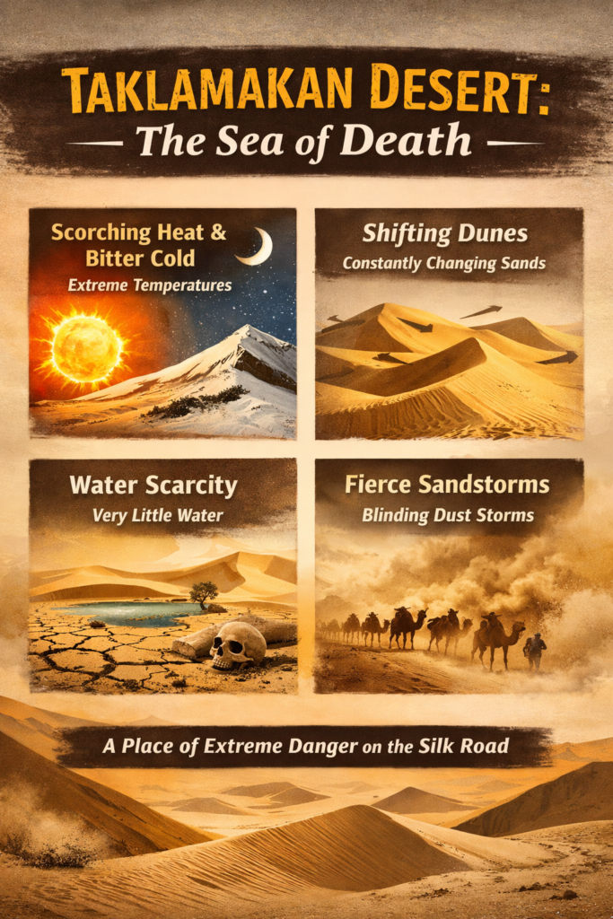
The nickname makes sense once you look at the desert’s main hazards as a system rather than as isolated problems. The Taklamakan is dangerous because it combines water scarcity, moving dunes, dust storms, temperature extremes, and severe isolation. Each factor is serious on its own. Together, they create a landscape that has Historically punished anyone who underestimated it.
1) Extreme lack of water
Water is the first and most obvious reason the Taklamakan earned such a fearsome reputation. Annual precipitation is tiny, and in some parts of the desert it can fall to only a few dozen millimeters per year. That is not enough to sustain reliable surface water across the interior. Rivers from the surrounding mountains may feed parts of the basin, but many of them disappear into sand, seep away, or dry out before they can cross the desert in full.
For travelers, this is the decisive danger. People can tolerate heat if they have water. Caravans can cross long routes if they know where the next oasis or well is located. But in the Taklamakan, water is irregular, limited, and often far apart. That is why the desert feels like a sea: once you enter it, the route is not obvious, and your survival depends on hidden, scattered “islands” of life.
2) Shifting dunes that erase the route
The Taklamakan is not a flat, stable expanse of sand. Its core is a massive erg, meaning a dune sea made of constantly shifting sand. In practical terms, this means the ground is in motion. Wind reshapes the terrain, tracks disappear, and landmarks become unreliable. What looked like a safe passage yesterday may be buried or altered today.
This is one of the reasons the desert is compared to the ocean. Just as waves are never still, the sand surface keeps changing. The landscape seems to flow. For anyone trying to navigate by memory or by visible signs, that movement creates confusion and risk. A path can vanish with surprising speed, which is why the desert has long inspired caution and dread.
3) Violent dust storms and low visibility
Dust storms are among the Taklamakan’s most dangerous features. Strong winds can lift huge amounts of sand and dust into the air, reducing visibility to almost nothing. In some seasons, the atmosphere can become thick with airborne particles, turning the sky into a wall of haze. Winds may also carry dust high into the atmosphere, spreading it across long distances.
For travelers, that is a serious threat. Dust storms can obscure direction, bury tracks, damage equipment, irritate the eyes and lungs, and leave people disoriented. In older times, a storm could easily separate a caravan from its route or its water supply. Even now, these storms remain a major environmental and infrastructure challenge.
4) Severe temperature swings
The Taklamakan is harsh in every season, but the nature of that harshness changes throughout the year. Summer temperatures can become intense, while winter can bring bitter cold. In other words, this is not just a hot desert; it is a desert with a wide and punishing annual temperature range.
That distinction matters. Many people imagine desert danger only as scorching daytime heat. The Taklamakan proves otherwise. Its winter cold can be just as dangerous as its summer heat, especially when combined with wind, dry air, and exposure. The desert is therefore a year-round test of endurance rather than a seasonal challenge only.
5) A long history of danger on the Silk Road
The Taklamakan’s reputation did not arise from legend alone. It was built through centuries of real human experience. Silk Road routes did not run safely through the center of the desert. Instead, they followed the margins, because the middle was too risky. Oasis towns offered the water, rest, and orientation that caravans needed to survive.
This historical pattern is important. The nickname Sea of Death was not invented in a vacuum. It reflects the practical knowledge of merchants, monks, explorers, and local communities who understood the consequences of entering the interior without preparation. A desert becomes infamous when it repeatedly defeats travelers, and the Taklamakan did exactly that.
The Silk Road and the Taklamakan Desert
The Silk Road is central to the Taklamakan’s fame. This vast network of caravan routes connected China with Central Asia and beyond, but it did not pass through the most dangerous part of the desert. Instead, it traced the northern and western edges, where settlements and oasis systems made travel possible.
That choice says a lot. It shows that the Taklamakan was never ignored; it was simply respected. Traders, monks, and diplomats moved around its perimeter because the center posed too much danger. The caravan route depended on strategic planning, seasonal timing, and reliable stops. In that sense, the Taklamakan shaped the route just as much as the route shaped the region.
Important oasis towns around the desert
Several oasis and river-valley settlements became essential to life around the Taklamakan. These include Kashgar, Miran, Niya, Yarkand, Khotan (Hotan), Kuqa, Turpan, Loulan, and Dunhuang. These were not just rest stops. They were living hubs where trade, religion, culture, and language converged.
For travelers, these towns meant three critical things: water, shelter, and direction. In desert geography, those three things are more valuable than almost anything else. A city at the edge of the Taklamakan was not simply a settlement; it was a survival anchor.
Why traders avoided the center
The center of the desert was avoided for a simple reason: the cost of failure was too high. When a caravan became lost, it could run out of water before reaching the next safe point. If the wind changed the terrain, routes could vanish. If a dust storm rose suddenly, visibility could drop to nearly zero. The combination of uncertainty and exposure made the interior a poor choice for ordinary travel.
This is why the Sea of Death nickname is also a history lesson. It tells us that geography can control movement, commerce, and settlement patterns over long periods of time. The Taklamakan was not simply a historical background. It was one of the forces that shaped history.
Climate of the Taklamakan Desert
The Taklamakan’s climate is not only dry; it is strongly continental. That means the desert experiences large seasonal shifts, little moisture, and intense atmospheric instability compared with more moderate environments. The climate is a major reason the desert remains so difficult to inhabit and cross.
What the climate feels like in simple terms
In summer, the Taklamakan can become scorching. In winter, it can turn sharply cold. At certain times of the year, the desert behaves almost like two different environments. This wide temperature range makes clothing, shelter, water management, and travel timing all critically important.
The climate is also wind-driven. Strong air currents help shape the dunes, move dust, and intensify erosion. Spring is especially notorious for storms, but dust activity can affect the desert throughout much of the year. The result is not a still, silent wasteland but a dynamic, unstable system.
Why does rainfall stay so low?
The Tarim Basin is bordered by mountains, and those mountains block or redirect much of the moisture that would otherwise reach the interior. Because the desert sits inside an enclosed basin, rainfall does not distribute evenly across the landscape. The little moisture that arrives is quickly offset by evaporation.
This is why oases can exist near the edges while the center remains extremely harsh. Water is present in the broader region, but it does not circulate evenly through the whole desert. The geography keeps the interior dry and the outer margins comparatively livable.
Geography and Landscape Features
The Taklamakan is often imagined as one endless stretch of sand, but the landscape is more varied than that. It contains shifting dunes, clayey zones, sparse vegetation in certain areas, and more hospitable margins near river valleys and groundwater-fed depressions.
The center of the desert
The heart of the Taklamakan is the most extreme and unstable part of the landscape. Here, sand dominates. Dunes rise, shift, and merge with the wind. Ground markers are unreliable, and the terrain can feel almost liquid in its motion. This is the true “sea” part of the Sea of Death image.
The center is also the least forgiving zone for humans and animals alike. It offers very little in the way of shelter, food, or dependable water. The desert’s most intimidating reputation comes from this core region.
The edges of the desert
The margins are different. They are not comfortable, but they are more survivable. River valleys, deltas, and groundwater-fed zones support more plants, more wildlife, and more human activity. These edges are where oasis societies developed, where caravans stopped, and where agriculture was possible in limited but meaningful ways.
The contrast between the center and the edges is one of the Taklamakan’s defining features. It shows that the desert is not a uniform space. It is a layered environment with zones of extreme hostility and zones of relative refuge.
Why does the landscape look like? a sea
The sea comparison is not merely poetic. Dune ridges can resemble waves. Wind makes them shift. The overall surface looks alive, as if the ground is moving under the sky. For a traveler standing in the middle of the desert, this can feel deeply unsettling, because the familiar anchors of land-based navigation are missing.
That is why the name Sea of Death works so well. It is visually accurate, emotionally powerful, and historically grounded.
Flora: What Plants Can Survive in the Taklamakan?
Plant life in the Taklamakan is extremely limited, but not absent. The majority of the desert has little to no permanent plant cover. Wherever groundwater is close to the surface, however, life begins to appear. In depressions, along edges, and near river systems, you can find hardy desert vegetation that has adapted to dry conditions.
Typical plants include tamarisk, nitre bushes, reeds, Turanga poplar, oleaster, camel thorn, and salt-tolerant shrubs. These species survive because they are tough, resource-efficient, and adapted to harsh aridity.
Why is plant life sparse?
Plants need water, and most of the Taklamakan does not provide enough of it for broad vegetative growth. Sand also shifts constantly, making root stability difficult. As a result, the landscape is mostly bare except in places where water creates a narrow ecological foothold.
A simple way to picture it
Imagine walking from an oasis edge into the dune field. At first, you may see shrubs, trees, and reeds. A little deeper in, the vegetation thins. Eventually, it disappears almost entirely. That transition is the Taklamakan in miniature: life exists in pockets, and only where conditions allow it.
Fauna: What Animals Live There?
Animal life is sparse, too, but the desert is not lifeless. The better-supported areas near river valleys, deltas, and peripheral habitats can host a surprising range of species. These include gazelles, wild boars, wolves, foxes, Siberian deer, wild camels, rabbits, gerbils, field mice, jerboas, hedgehogs, bats, larks, and the Tarim jay.
This tells us something important: the Taklamakan is not a dead zone. It is a survival zone. Life persists where conditions permit it, and the animals that survive here are the ones adapted to scarcity, heat, cold, and long distances between reliable resources.
Why animals stay near the edges
The edges provide food, water, and shelter. The deep core provides much less support. So the animal distribution follows the same pattern as the plant distribution: denser near the margins, thinner toward the center. This is one more reason the desert is so closely tied to the idea of boundaries.
Human History, Exploration, and Archaeology
The Taklamakan is not only a geographical formation. It is also a historical landscape. Human communities lived, traded, worshipped, and built settlements around their margins for centuries. Some of those communities left behind ruins that were later buried by sand or abandoned as trade patterns changed.
Exploration of buried ruins
Scientific exploration of the region became especially important in the late 19th century, when explorers such as Sven Hedin and Aurel Stein investigated ruined settlements and uncovered Buddhist artifacts. These discoveries showed that the desert had once been part of a much more active human world than many outsiders had imagined.
That matters because it corrects a common misconception: the Taklamakan was never truly empty. Its edges supported life, exchange, and culture. The desert’s reputation for emptiness comes from its most inhospitable core, not from the whole region.
The desert as a landscape of memory
The Taklamakan is also a landscape of disappearance. Towns were buried, routes changed, water shifted, and some communities faded from the map. As a result, the desert holds not only danger but also archaeological memory. It preserves traces of the people who once lived near its edge.
Why the Taklamakan Was So Hard to Cross
Crossing the Taklamakan was difficult for several connected reasons:
- There was no reliable water across the interior.
- The dunes shifted and erased landmarks.
- Dust storms reduced visibility and direction.
- Temperatures changed dramatically across the year.
- The desert sat inside a basin that limited easy escape routes.
To survive, a traveler needed a string of advantages all at once: water, navigation, stable ground, timing, and a workable plan. If even one of those failed, the result could be disastrous.
A simple survival chain
First, a traveler needed water. Then they needed a route. Then they needed terrain that would hold. The Taklamakan made all three difficult at the same time. That is why it became infamous. A place that defeats preparation over and over eventually becomes known as a place of death, even though it is not “evil” in any human sense. It is simply unforgiving.
Modern Roads, Railways, and Human Adaptation
The Taklamakan is still harsh today, but modern engineering has changed the way people move around and through parts of it. Roads have been built around the edge of the basin, and in some cases across portions of the interior. These routes make the desert more accessible than it once was, especially for nearby communities and regional transport.
The railway loop
One of the most notable modern developments came in June 2022, when China opened the Hotan-Ruoqiang Railway, creating the world’s first railway loop around a desert. The line is about 825 km long and forms part of a broader 2,712-km loop around the Taklamakan. Much of the construction had to contend with sand, wind, and unstable conditions.
The engineering behind this project is striking. Workers planted shrubs and trees along parts of the line, and bridges were used in some areas, so wind and sand could pass beneath them more easily. This is a major example of how humans are learning to coexist with a hostile landscape rather than simply trying to conquer it.
What this changes—and what it does not
Infrastructure has improved access, logistics, and regional connection. But it has not made the Taklamakan gentle. The interior remains harsh, and the basic climate challenge remains the same. Modern roads and railways make navigation more reliable, but they do not erase the desert’s core identity.
Environmental Problems and Conservation Updates
The Taklamakan is not only a survival challenge; it is also an environmental challenge. Desert expansion, sand movement, dust storms, and ecosystem fragility all create pressure on the surrounding regions. Conservation work has therefore become a major part of the modern story.
The role of poplar forests
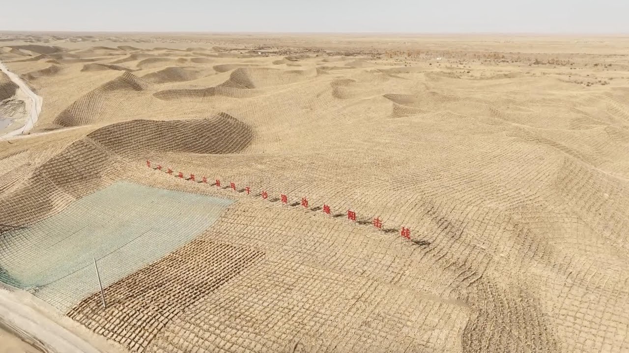
Poplar forests along the Tarim River are especially important because they help stabilize dunes, slow desertification, reduce dust storm impact, and support biodiversity. These forests function as ecological buffers, protecting both human communities and fragile riverbank systems.
Green belt efforts
In November 2024, Reuters reported that China completed a 3,000-km green belt around the Taklamakan after a long-running anti-desertification campaign. This effort is meant to help reduce sand movement and stabilize the desert’s edge. At the same time, the reporting also highlighted ongoing concerns about plant survival and the continued difficulty of controlling such a massive desert system.
That balance is important. The green belt is a significant achievement, but it is not a magic solution. The desert remains immense, and climate pressures are still real. Conservation is a long-term effort, not a one-time fix.
Interesting Facts About the Taklamakan Desert
The Taklamakan is one of the largest sandy deserts in the world and among the harshest arid environments in Asia. It is characterized by extremely low rainfall, strong dust activity, and dramatic seasonal temperature changes. Its dunes can be highly mobile, and its interior is one of the least forgiving environments for overland travel.
Another important fact is that the desert is not just a local phenomenon. It contributes to broader dust systems and regional environmental dynamics. It is therefore both a geographic feature and a climatic force.
More fast facts
- The desert lies inside an internal drainage basin.
- Silk Road routes ran around its edges rather than through the most dangerous core.
- Oases were the lifeline for trade, settlement, and survival.
- Modern rail and road systems now improve access around parts of the basin.
- Conservation and sand-control work continue to reshape the region’s borders.
Myths vs Facts
| Myth | Fact |
| The Taklamakan is just empty sand with no life. | Oasis edges support plants, animals, and human settlements. |
| Nobody ever traveled through it. | Silk Road routes skirted the desert and connected major oasis towns. |
| The nickname is only a poetic exaggeration. | The nickname reflects real danger from water loss, dunes, storms, and isolation. |
| Modern infrastructure made the whole desert safe. | Roads and railways help around the basin, but the interior remains harsh. |
Pros and Cons of the Taklamakan Desert
Pros
The Taklamakan has enormous historical value because it sits beside the Silk Road and contains important ruins, old trade networks, and archaeological remains. It is also visually dramatic, which makes it valuable for research, photography, and environmental study. Modern roads and railways have improved access around parts of the basin, making the region more connected than it used to be.
Cons
The desert is extremely dry, highly windy, and dangerous to cross without support. Dust storms can be severe, water is scarce, and the interior remains very hard on both people and machinery. Even modern conservation projects cannot remove the fundamental harshness of the climate.
Why Is the Taklamakan Desert Nicknamed the Sea of Death?
The Taklamakan Desert is called the Sea of Death because its dry climate, moving dunes, dust storms, temperature extremes, and long history of isolation made it one of the hardest places for travelers to survive. The name Taklamakan is often linked to ideas of leaving or abandonment, which fits the desert’s reputation as a place entered at serious risk. The Silk Road avoided the desert’s center and stayed near oasis towns, proving that people understood the danger long before modern roads and railways changed the region.
FAQs
It is called the Sea of Death because it is extremely dry, filled with shifting dunes, hit by strong dust storms, and historically dangerous for travelers. The nickname reflects real geography and real survival risk.
Scholars usually connect it to a Uyghur name probably derived from Arabic tark and makan, with meanings that suggest leaving or relinquishing a place. Popular usage often turns this into the idea of a place of no return.
No, but it is very hard to cross safely. Historically, travelers avoided the center and used the oasis routes around the edges. Today, roads and railways improve access around parts of the basin, but the interior remains harsh.
There is no fixed population in the desert core. Human life is concentrated around oasis towns, river valleys, and the desert’s outer margins where water is available.
Its mix of huge shifting dunes, very low rainfall, internal basin geography, strong dust storms, and Silk Road history makes it one of the most famous and feared deserts in the world.
Yes. China completed a 3,000-km green belt around the desert in 2024, and the region is also surrounded by major transport projects like the 2022 railway loop. These changes help manage sand and connect communities, even though the desert itself remains harsh.
Conclusion
The Taklamakan Desert earned the name “Sea of Death” because it is vast, dry, unstable, and extremely difficult to survive in. From its shifting sands to its Silk Road history, the desert has long been a place of danger, mystery, and respect. Even today, it remains one of the world’s most formidable landscapes.


