Introduction
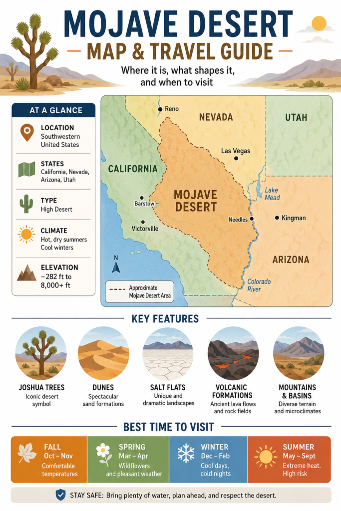
The Mojave Desert is one of the most famous desert regions in the southwestern United States. It stretches mainly across southeastern California and parts of Nevada, Arizona, and Utah. Known for its dramatic landscapes, Joshua trees, dunes, salt flats, and wide open views, the Mojave attracts travelers, photographers, and nature lovers from around the world. This guide explains where the Mojave Desert is, what defines its boundaries, what its climate is like, and when it is safest to visit.
Where Is the Mojave Desert on the Map?
If you open a map of the southwestern United States, the Mojave Desert appears inland, mainly in southeastern California and southern Nevada, with smaller extensions into Arizona and Utah. It occupies a wide desert corridor between major mountain systems and higher plateaus, which is one reason it has such a distinct appearance and identity.
Its position on the map is important because the Mojave is not a neatly defined political boundary. It is a transition zone. Its edges are influenced by ecology, elevation, geology, rainfall, and plant communities rather than county or state boundaries. In practical terms, that means the Mojave changes gradually as you move outward, rather than stopping at a clean line.
This is why a Mojave Desert map can look different depending on the source. Some maps emphasize landforms. Some highlight vegetation. Some focus on protected lands. Some define the desert by climate or species distribution. All of those approaches are valid, but they all show the same basic truth: the Mojave is a broad high-desert region of the American Southwest, with most of its area in California and Nevada.
That map location also explains its travel appeal. The desert sits between famous mountain ranges, national parks, and interstate routes, which makes it accessible while still feeling remote. For many visitors, that mix of accessibility and openness is exactly what makes the Mojave so memorable.
Which States Does the Mojave Desert Cover?
The Mojave Desert covers California, Nevada, Arizona, and Utah. That is the simplest answer, but the distribution is uneven. The largest share lies in California and Nevada, while the Arizona and Utah portions are smaller and more transitional.
This uneven spread matters for travelers because the desert is often experienced through landmarks rather than as one continuous block. A person entering from Southern California may connect the Mojave with Joshua Tree, Mojave National Preserve, or the Kelso Dunes. Someone traveling from Nevada may think first of the desert near the Colorado River or the perimeter of Lake Mead. In Arizona and Utah, the Mojave usually appears as a fringe ecology or an overlapping desert zone rather than an obvious standalone expanse.
That is one reason the Mojave is so interesting. It is not a simple rectangle of hot land. It is an ecological region that crosses administrative boundaries, shifts in character from one area to another, and includes several famous destinations that each represent a different side of the desert experience.
What Are the Boundaries of the Mojave Desert?
The boundaries of the Mojave are ecological, not political. The desert blends into the Great Basin Desert to the north and the Sonoran Desert to the south and southeast. That means the outer edge is gradual rather than abrupt. Instead of a hard stop, there is a transition in elevation, plant life, moisture, and terrain.
This is why different sources may show slightly different Mojave outlines. Some definitions are broader and include the full ecological footprint. Others are narrower and focus on certain plant indicators, especially the Joshua tree. Some versions are based on geology or landform patterns. Some are based on protected lands and management zones. The desert is real, but its boundary is flexible because nature does not follow administrative borders.
A good way to picture the Mojave is as a basin-and-range landscape where topography, water availability, and elevation matter more than state lines. That is also why the region includes such a wide range of terrain: open flats, rocky slopes, dunes, volcanic fields, dry washes, salt crusts, and isolated water sources.
Why the Mojave Desert Feels So Different
The Mojave has a very strong identity because it is often a high desert rather than a low, flat heat zone. Some areas sit at elevations that produce cool nights, frosty winters, and wide temperature swings between day and evening. That makes the Mojave feel more layered and more varied than many people expect.
The terrain also changes quickly. One valley can be broad and open, with pale gravel and sparse vegetation, while a nearby ridge may be cooler, rockier, and covered in different plant communities. In a single road trip, travelers can pass from dunes to lava fields to salt basins to mountain passes. That contrast is a major part of the Mojave’s visual power.
Another reason the desert feels unique is scale. The basin-and-range structure creates long sightlines, distant horizons, and dramatic silence. It is the kind of landscape that makes distance feel bigger and time feel slower. For photographers, road-trippers, hikers, and stargazers, that atmosphere is one of the biggest attractions.
Climate and Weather Patterns in the Mojave
The Mojave Desert climate is dry, but it is not uniform. Some places are hotter, some are windier, and some are cooler because elevation changes quickly across the region. The desert gets only a small amount of annual precipitation, and many parts experience strong temperature extremes between day and night.
Summer is the most difficult season. Heat can become intense, dehydration can happen fast, and driving or hiking without planning can become dangerous. Spring and autumn are usually the most comfortable travel seasons because Temperatures are more manageable and outdoor activities feel safer. Winter can be cold, windy, and frosty in higher areas or at night, which surprises many first-time visitors who expect desert conditions to mean constant heat.
Elevation is one of the biggest factors shaping weather. Lower basins can feel scorching, while higher ridges and mountain zones may remain much cooler. That is why the Mojave is often described as a land of contrasts. In one day, a traveler may move through blazing sunshine, dusty wind, cool canyon shade, and chilly evening air.
Rain, Wind, and Seasonal Changes
Rain in the Mojave is scarce, but when it arrives, it can have a huge impact. Most of the precipitation comes in cooler periods, and many backcountry water sources can be unreliable after long dry spells. That makes planning essential for anyone hiking, camping, or driving through remote areas.
The desert also has a strong wind story. Wind can sweep across open basins, shift sand, shape dunes, and make temperatures feel more severe than they actually are. Even when the sky looks clear, desert wind can be strong enough to change comfort, visibility, and travel conditions.
Seasonal change matters a great deal here. In spring, the desert can briefly feel alive with color after rain. In summer, it becomes harsher and riskier. In autumn, temperatures start to soften again. In winter, some areas can be quite cold at night. The Mojave is never static; it shifts with the season in ways that are easy to underestimate.
Landscape Features: More Than Sand
The Mojave Desert is not simply a sandy expanse. It is a landscape of enormous variety. It includes mountain ranges, dry basins, salt flats, canyons, caves, lava flows, dune systems, and broad open views that seem to continue forever. That diversity is part of what makes it such a strong travel destination.
People often imagine the desert as a monotone environment, but the Mojave proves otherwise. One area might feature pale salt crust and flat white ground. Another might show dark volcanic rock and jagged cliffs. Another may carry tall dunes or Joshua tree woodland. This mixture gives the desert a dramatic, almost layered character.
The region is also geologically rich. Its rock formations, volcanic remnants, and mountain-and-basin structure reveal a long history of tectonic movement and erosion. That means the Mojave is not only beautiful; it is also a powerful outdoor classroom for geology, ecology, and landscape history.
Mountain-and-basin terrain
One of the defining features of the Mojave is its mountain-and-basin pattern. Broad dry basins lie next to isolated mountain ranges, creating a rugged but open visual rhythm across the landscape. This is why the desert often feels spacious. The eye can travel across wide flats toward distant ridges, which makes the land seem immense.
This terrain also creates microclimates. A basin may be hot and dry while a nearby slope is cooler and more sheltered. Different elevations support different species, which is another reason the Mojave looks and feels varied from one zone to the next.
Dunes
The Mojave includes some of California’s most famous dune systems. The dunes are not just visually impressive; they are also fun to explore during sunrise, sunset, or cooler parts of the day. Their shifting forms make them one of the most photogenic parts of the desert.
Dunes are important for both travel and search intent because many readers want to know what the Mojave actually looks like. Dunes help answer that instantly. They bring motion, texture, and a classic desert image into the broader Mojave story.
Salt flats
The Mojave is also known for its salt-flat landscapes, especially in Death Valley. Salt flats create one of the most dramatic desert views in North America. Their bright, cracked surfaces can look solid, but they are often delicate and fragile. That fragility is part of their beauty and part of why visitors must treat them with care.
Salt flats also remind travelers that the desert is not lifeless. It is just highly specialized. Even a surface that appears empty may hold ecological, geological, or cultural significance.
Volcanic rock, caverns, and desert formations
Another striking aspect of the Mojave is its volcanic and subterranean geology. Ancient lava flows, limestone caverns, black rock fields, and eroded desert formations give the region a dramatic, almost otherworldly quality. This is one reason the Mojave is so appealing to road-trippers and landscape photographers.
Instead of one repeated desert scene, the region delivers a sequence of changing visuals. That variety helps turn the Mojave into a destination with real depth, not just a pass-through zone between larger cities.
Plants of the Mojave Desert
Plant life in the Mojave has evolved to handle heat, dryness, sudden rain, cold nights, and poor soil. The region’s vegetation is sparse in some areas but surprisingly diverse overall. Plants must conserve water, withstand stress, and survive in an environment that does not offer easy growing conditions.
The Joshua tree is the plant most closely associated with the Mojave. It is one of the strongest visual symbols of the desert, and many people recognize the look of the landscape even if they do not know the plant’s name. The Joshua tree gives the Mojave much of its identity.
Other important desert plants include creosote bush, yucca species, blackbrush, and a range of shrubs, grasses, and forbs that support desert habitat and restoration work. This is a key point for readers who assume desert means emptiness. The Mojave is not empty. It is a functioning biological system built for survival in harsh conditions.
Why Joshua trees matter
Joshua trees matter because they are both ecological and symbolic. They help define the visual profile of the Mojave, and they are strongly tied to the region’s identity in travel photography, conservation, and public memory. When people picture the desert with spiky silhouettes against a glowing sky, they are often picturing Joshua trees.
That makes them important for SEO as well. A Mojave Desert article naturally benefits from including Joshua tree-related wording because it matches how people search, how they imagine the landscape, and how they recognize the region.
Animals and Wildlife in the Mojave
The Mojave Desert supports wildlife that has adapted to heat, drought, and open terrain. The animal community includes reptiles, birds, mammals, and insects that depend on timing, shelter, and scarce water sources. Many species avoid the harshest heat by moving at dawn, dusk, or night.
The desert tortoise is one of the best-known species associated with the Mojave. It is an especially important symbol of desert conservation because it reflects the delicate balance of the region’s ecosystem. The presence of desert tortoise habitat also signals the broader health of the land.
Wildlife in the Mojave is often hidden rather than obvious. That does not mean it is absent. It means the desert rewards patience, quiet observation, and respect for habitat. If travelers slow down, they may notice tracks, burrows, birds of prey, lizards, or insects that reveal how active the ecosystem actually is.
Human History and Indigenous Heritage
The Mojave is not an empty place. It has a long human history stretching back thousands of years. People have crossed, lived in, traded through, and depended on this desert for a very long time. Its history includes adaptation, migration, survival, and cultural continuity.
The Mojave people are central to that story. They were deeply connected to the Colorado River, trade routes, seasonal movement, and the practical knowledge needed to live in a demanding desert environment. The desert was not simply a backdrop to their lives. It was a homeland, a pathway, and a living cultural space.
Later centuries brought new layers of history, including railroads, mining, tourism, federal land designations, and conservation efforts. Historic depots, old travel corridors, and preserved landscapes now tell part of that story. When visitors drive through the region, they are crossing a landscape shaped by both natural forces and human memory.
Best Places to Visit in the Mojave Desert
The best Mojave travel content should answer a practical question: where should a visitor actually go? That depends on the kind of experience they want. Some people want famous landmarks. Others want solitude. Some want easy scenic access. Others want dramatic geology or classic desert photography.
Here is a useful overview:
| Place | Why it matters | Best for |
| Death Valley National Park | Famous for extreme salt-flat scenery and the lowest point in North America. | Scenic drives, photography, and geology |
| Joshua Tree National Park | Where two desert ecosystems meet, with iconic trees and dramatic rock formations. | First-time visitors, classic desert views |
| Mojave National Preserve | A vast remote preserve with dunes, lava flows, caverns, and Joshua tree habitat. | Road trips, hiking, solitude |
| Mojave Trails National Monument | A broad desert monument with historic routes, dunes, and rugged terrain. | Backcountry scenery, historic travel corridors |
| Lake Mead National Recreation Area | A place where desert and water meet in a striking contrast. | Recreation, scenic variety |
This list works well because it reflects how real visitors search and plan. Most people do not come to the Mojave in the abstract. They come to specific destinations inside it.
Death Valley National Park
Death Valley is one of the strongest anchors for any Mojave travel guide. It is famous for its stark salt basin, extreme landscape, and record-setting low point below sea level. Its scenery is powerful because it combines scale, heat, stillness, and geological contrast.
For many travelers, Death Valley is the moment when the Mojave becomes unforgettable. The land feels immense, silent, and almost lunar in places. That sense of intensity is part of its appeal.
Joshua Tree National Park
Joshua Tree is where many people first encounter the Mojave in a visual sense. The park is iconic because it blends open desert, sculpted granite, and the distinctive shape of the Joshua tree. The result is a landscape that feels both wild and approachable.
It is also one of the easiest places for first-time visitors to connect with the desert. The roads, vistas, rock formations, and well-known plant life make it a strong entry point into the broader Mojave story.
Mojave National Preserve
Mojave National Preserve is ideal for travelers who want more space, more quiet, and a deeper desert feeling. It brings together dunes, lava fields, Joshua tree forests, wide roads, and a long human timeline. It is less crowded than some famous parks and more immersive for visitors who want open silence.
The preserve also helps explain the Mojave as a whole because it contains so many of the region’s major features in one protected area.
Mojave Trails National Monument
Mojave Trails National Monument broadens the travel story beyond the best-known parks. It includes rugged mountains, desert corridors, and historic travel routes, which makes it especially interesting for people who like road-trip style exploration and backcountry scenery.
This monument is important because it shows that the Mojave is not only about one or two famous spots. It is a wide system of landscapes connected by ecology and history.
Best Time to Visit the Mojave Desert
For most travelers, the best time to visit the Mojave Desert is from fall through spring, especially October through April. During that window, temperatures are usually more manageable, outdoor travel feels safer, and the experience is far more comfortable.
Summer is the toughest season. The heat can become intense very quickly, and the risks rise when people underestimate distance, water needs, or vehicle trouble. Desert travel is not only about beauty. It is also about preparation.
Winter can also be interesting, especially for visitors who enjoy cooler air, clear skies, and fewer crowds. But nighttime temperatures can drop sharply, so even winter trips need planning.
In short, the Mojave is best enjoyed when the weather supports slower travel, longer stops, and safer outdoor movement.
How to Stay Safe in the Mojave
Safety should be one of the central sections in any Mojave Desert travel guide. This is not a place for casual improvisation. It is remote, exposure can be severe, and services may be far apart.
The most important safety principle is simple: bring more water than you think you need. People often underestimate how fast dehydration can happen in the desert. It is also essential to start with a full tank of fuel or a fully charged vehicle, because service stations and charging points may be limited.
Travelers should also tell someone where they are going, keep track of route timing, and never assume a phone will work everywhere. In many parts of the Mojave, cell coverage is weak or unreliable.
Another crucial rule is to respect the terrain. Do not drive off-road on fragile surfaces, do not trust a dry wash during rain, and do not walk on delicate salt or soil formations if the area says not to. The desert may look tough, but many of its surfaces are surprisingly easy to damage.
A safe Mojave trip is a prepared Mojave trip.
Travel Tips for a Better Mojave Trip
A strong Mojave trip combines planning, patience, and respect for the landscape. Early starts are helpful because temperatures are cooler and the light is better for photography. Extra water is always necessary. Sun protection matters even when the temperature feels mild. Offline maps are smart because signal loss is common.
Visitors should also check road conditions, weather forecasts, and park alerts before heading out. Desert conditions can change quickly, especially after rain or strong winds. If you are visiting dunes, salt flats, or remote roads, move slowly and carefully. If you are driving long desert stretches, make fuel a top priority.
The best trips in the Mojave usually happen when people stop rushing. The desert rewards stillness. Sunrise, sunset, wide pullouts, and quiet scenic stops often create the most lasting memories.
Conservation and Environmental Challenges
The Mojave Desert is not just a travel destination. It is also a fragile ecosystem facing real environmental pressure. Invasive grasses can increase wildfire risk, human development can fragment habitat, and recreation can damage sensitive terrain if visitors are careless.
Climate stress also matters. Rising temperatures, lower moisture availability, and reduced groundwater recharge can place additional pressure on plants and animals that already live close to environmental limits. That is especially important in a region where survival already depends on scarcity and adaptation.
This is why conservation belongs in the same article as travel. Visiting the Mojave responsibly means staying on roads, avoiding damage to crusts and plants, respecting cultural sites, and treating the desert as a living system rather than an empty backdrop. Good travel behavior is also conservation behavior.
Interesting Facts About the Mojave Desert
The Mojave Desert has many memorable facts that make it easy to explain and easy to remember. One of the most striking is how little precipitation it receives each year. Another is the existence of Badwater Basin, one of the most famous low points in North America. Another is the desert’s ecological complexity, which gives it a boundary that is easier to describe in natural terms than in political terms.
A second important fact is that the Mojave is not empty. It contains specialized plants, hidden wildlife, historical travel routes, protected lands, and living cultural landscapes. That makes it one of the most interesting desert regions in the world from both a scientific and a travel perspective.
A final fact worth remembering is that the Mojave combines scenery, geology, ecology, and human history in a single region. That combination gives it lasting search value and strong real-world appeal.
Pros and Cons
Pros
The scenery is incredibly varied, with dunes, salt flats, lava flows, caverns, Joshua trees, and mountain basins.
It is excellent for road trips, landscape photography, geology, hiking, and stargazing.
It has deep cultural meaning, including Indigenous heritage and historic travel corridors.
Cons
Summer heat and dehydration risk can be severe.
Gas, charging, and cell service can be limited in remote areas.
Sensitive ground, salt crusts, and habitat zones can be damaged easily if visitors are careless.
FAQs
No. Mojave National Preserve is one protected area inside the larger Mojave Desert. The preserve is part of the broader ecological region, but it is not the entire desert.
There is no single fixed answer because the Mojave is an ecological region, not a political boundary. Its size depends on how it is defined, whether by landform, vegetation, climate, or management map.
For most people, October through April is the most comfortable and practical window. Temperatures are usually easier to manage, and travel is safer than during peak summer heat.
The Mojave supports a wide range of desert-adapted wildlife, including reptiles, birds, mammals, insects, and the desert tortoise. Many species are active at cooler times of the day or night.
It matters because it combines distinctive geography, iconic landscapes, cultural heritage, specialized plants and animals, and serious conservation issues. It is one of the most recognized desert regions in the American Southwest.
Conclusion
The Mojave Desert is more than a dry place on the map. It is a vast and varied landscape shaped by climate, elevation, geology, and time. Spanning parts of California, Nevada, Arizona, and Utah, it offers some of the most striking desert scenery in North America. Whether you are looking at a Mojave Desert map or planning a trip, this desert is memorable for its beauty, history, and unique natural character.


