Introduction
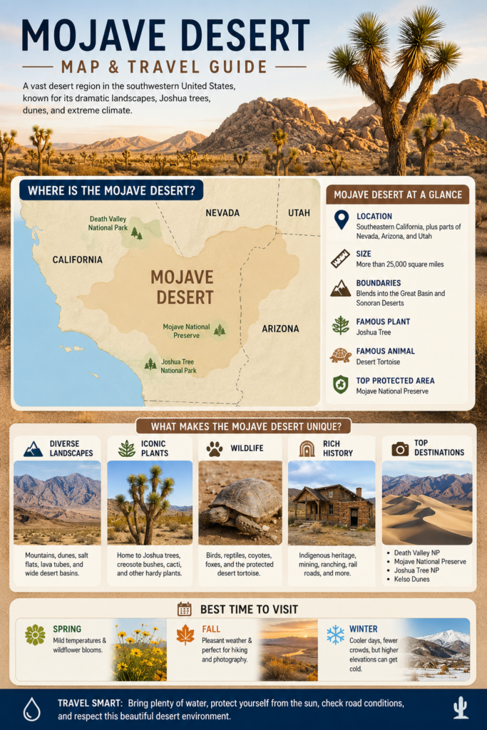
The Mojave Desert is a vast desert region in the southwestern United States, mainly in southeastern California, but also reaching parts of Nevada, Arizona, and Utah. Known for its dramatic landscapes, Joshua trees, dunes, and extreme climate, it is one of North America’s most famous desert regions. This guide explains where the Mojave Desert is, what borders it, and the best time to visit safely.
Mojave Desert at a Glance
| Topic | Key detail | Why it matters |
| Main location | Southeastern California, plus parts of Nevada, Arizona, and Utah | Shows the desert crosses state lines |
| Size | More than 25,000 square miles | Explains why it feels vast and varied |
| Boundary type | Blends into the Great Basin and Sonoran deserts | Helps explain the changing scenery |
| Famous landmark | Death Valley sits near the Great Basin–Mojave border | A major reason people search for the region |
| Best-known plant | Joshua tree | A signature symbol of the Mojave |
| Best-known protected area | Mojave National Preserve | A top destination for visitors |
The Mojave is not a single-purpose place. It is part scenic wonder, part scientific landscape, part protected ecosystem, and part road-trip destination. That is why it has remained one of the best-known desert regions in North America.
Where Is the Mojave Desert Located?
The Mojave Desert is located in the inland Southwest of the United States, in a region where dry basins, mountain ranges, and high desert plateaus meet. Its strongest association is with California, especially the southeastern part of the state, but it is not limited to California alone. The desert also extends into Nevada, Arizona, and Utah. That means the Mojave is a cross-state desert region rather than a single-state feature.
A helpful way to picture it is as a high-desert corridor. Instead of one uniform flat expanse, the Mojave consists of connected landscapes that shift as elevation rises or falls. Some areas feel wide open and barren, while others are dotted with vegetation, ridgelines, volcanic features, dunes, or dry washes. This is one reason the Mojave Desert map can be misleading if people expect one simple boundary line. The region has ecological edges, not fence-like borders.
The Mojave also sits between other large desert systems. It connects with the Great Basin Desert to the north and the Sonoran Desert to the south and southeast. In some places, the transition is gradual, so the scenery changes slowly rather than abruptly. That blending helps explain why the Mojave has such a strong identity but is still part of a broader desert network in the American Southwest.
For many travelers, the Mojave is best known through landmark destinations such as Death Valley, Joshua Tree National Park, and Mojave National Preserve. These places help people understand the desert not only as a location, but as a sequence of distinct environments.
Quick answer for searchers
If someone asks, “Where is the Mojave Desert?”, the shortest accurate answer is: it is a large desert region in the southwestern United States, mainly in southeastern California and southern Nevada, with parts that extend into Arizona and Utah. It lies between other desert systems and includes some of the most recognizable desert scenery in North America.
Mojave Desert States and Boundaries
The Mojave Desert is spread across California, Nevada, Arizona, and Utah. Many people assume it is entirely a California desert because so much of its famous scenery is found there, but that is only part of the story. California does contain the largest and most visible share of the region, yet the desert itself does not stop at the California border.
The Mojave Desert boundaries are ecological, not political. That means the region is defined more by climate, elevation, plant communities, and landforms than by state lines. It merges into the Great Basin Desert in the north and into the Sonoran Desert in the south and southeast. In practice, this creates a Transition zone rather than a sharply drawn border. If you are driving through the area, the landscape can shift from one type of desert character to another without a dramatic line marking the change.
That boundary idea matters a lot for understanding the Mojave. Some people imagine a desert as a flat, endless, identical surface. The Mojave is not like that. It contains mountain fronts, dry basins, gravel plains, dunes, salt flats, rocky ridges, and elevation-driven habitat changes. The desert’s edges blend naturally into surrounding systems, which is why the region feels connected to, but still distinct from, the Great Basin and Sonoran deserts.
Joshua Tree National Park is especially helpful for understanding this overlap because the park lies where different desert systems meet. That makes it a useful reference point for anyone trying to understand desert boundaries in the Southwest. A visitor standing in one area may see vegetation and terrain that feel Mojave strongly, while another nearby area may show influences from a different desert zone.
Death Valley also helps explain the region’s border logic. It sits near the undefined boundary between the Great Basin and Mojave deserts and is famous for its extremely low elevation. That geography underscores the idea that the Mojave is shaped by terrain and climate, not by a tidy geometric shape.
Mojave Desert Climate: Hot, Dry, and Full of Contrasts
The Mojave Desert climate is defined by dryness, bright sun, low rainfall, and wide temperature swings. It is often described as hot, but heat alone does not fully explain the experience. The Mojave is also a desert of sharp contrast, where the temperature can feel very different from day to night, and where elevation changes can dramatically alter conditions.
On average, the Mojave receives very little precipitation, and the air is often dry enough to make the landscape feel stark and open. Rainfall is limited, evaporation is high, and water is one of the region’s most precious resources. In many parts of the desert, what looks dry is not just visually dry—it is climatically dry in a deep and sustained way.
Another major feature of the Mojave climate is elevation. Some locations sit much lower than others, and that elevation difference changes temperature, plant life, and even the feel of the air. Higher elevations tend to be cooler and can even receive snow in winter, while lower elevations can become extremely hot in summer. That is why the Mojave can feel like several different deserts rolled into one.
For visitors, the practical takeaway is simple: the best time to experience the Mojave comfortably is usually spring or fall. During those seasons, daytime temperatures are more manageable, the light is beautiful, and travel is less punishing. Summer can be brutal, especially in the lowest and most exposed places. Winter may be pleasant in some areas, but higher terrain can still get cold, windy, or snowy.
The climate is one of the main reasons the Mojave is both beautiful and dangerous. It rewards careful planning, but it punishes carelessness. That is why any serious Mojave Desert travel guide should include hydration advice, weather awareness, sun protection, and route planning.
Best Time to Visit the Mojave Desert
The most comfortable time to visit the Mojave Desert is generally spring or fall. These seasons offer milder temperatures, clearer conditions for sightseeing, and a better balance between daytime warmth and nighttime coolness. Spring is especially appealing because the desert can show subtle bursts of color after seasonal rains, while fall often provides stable weather and excellent outdoor conditions.
Summer is a different story. It can be intensely hot, especially in lower-elevation areas. Long hikes, midday road travel, and off-road exploration become much riskier during peak heat. If summer is the only possible travel window, then early morning starts, short outings, and a strong hydration plan become essential.
Winter can also be rewarding, especially for travelers who enjoy quiet landscapes, crisp air, and fewer crowds. But conditions vary. A valley floor may be mild while a higher pass is cold, windy, or icy. That’s why the Mojave is not one single climate experience. It changes by elevation, season, and location.
Joshua Tree National Park’s visitor patterns also help support the same idea. The park sees heavier travel in cooler months, which aligns well with the general comfort window for the region. That makes fall through spring the most travel-friendly period for many visitors.
Landscape Features: Dunes, Mountains, Salt Flats, and Lava Tubes
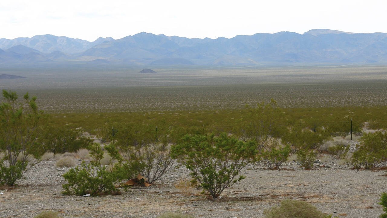
One of the biggest misconceptions about the Mojave Desert is that it is flat and empty. In reality, it is a landscape of texture and variation. The region includes mountain ranges, dry lakebeds, broad basins, rocky hills, volcanic features, dunes, and areas with surprisingly diverse vegetation. The result is a desert that feels visually rich rather than one-dimensional.
The Mojave is commonly described as a mountain-and-basin desert. That means the terrain alternates between elevated landforms and lower basin areas. In many places, the viewer can see wide horizons punctuated by ridges, cliffs, and distant peaks. Salt flats and gravel plains add another layer of visual contrast, especially in low-lying areas where water once pooled or still occasionally accumulates after rainfall.
The region is also famous for its dunes. Dune fields can look soft and flowing compared with the harder rock surfaces nearby. These dune areas create a dramatic sense of scale and movement, especially in changing light. They also remind visitors that deserts are not static. Wind keeps shaping them over time.
Volcanic geology is another important Mojave feature. Lava flows, volcanic cones, and lava tubes reveal the region’s deeper geological past. These features matter because they show that the Mojave is not just a climate zone; it is a geologic record of ancient eruptions, tectonic forces, erosion, and long-term environmental change.
Example: the Lava Tube
The lava tube in Mojave National Preserve is one of the best examples of the region’s geological variety and travel realities. It is not a roadside attraction in the casual sense. The access road is rough, sandy, and washboarded in places, and a high-clearance vehicle is recommended. Visitors must also prepare for the fact that remote desert sites often lack basic conveniences such as restrooms, trash cans, and regular services.
That makes the lava tube useful for more than geology. It is also a lesson in desert preparedness. A site can be fascinating and memorable, but it may also be isolated, difficult to reach, and unforgiving if a traveler arrives unprepared. That combination is part of the Mojave experience.
Flora: Plants of the Mojave Desert
The plant life of the Mojave Desert is sparse compared with wetter regions, but it is far from lifeless. Instead of thick forest cover, the desert features hardy, highly adapted vegetation that survives with minimal water and intense sun. This is one of the reasons the Mojave feels so distinct. The plants are few in number compared with many other biomes, but they are extremely well-suited to the environment.
The most iconic Mojave plant is the Joshua tree. It has become the visual emblem of the desert in the popular imagination, and for good reason. Its unusual shape, spiky leaves, and stark silhouette make it one of the most recognizable plants in the American Southwest. Joshua trees are strongly associated with the Mojave and help define its identity.
Another widespread and important plant is the creosote bush, which is one of the dominant shrubs in many desert landscapes. It is a classic Mojave species, often appearing in wide, open stands across dry ground. Alongside it, visitors may encounter other desert shrubs, cacti, yucca, and burroweed, each adapted to conserve water and survive punishing conditions.
Elevation plays a major role in the plant’s story. As the land rises, plant communities shift. In lower and mid-level areas, Joshua trees and desert shrubs may dominate. Higher up, more woodland-like desert associations can appear, such as pinyon-juniper communities. This gives the Mojave a layered botanical structure that many visitors do not expect.
Water-dependent zones, such as desert riparian habitats, are especially important. These areas may occupy only a small part of the landscape, but they support a disproportionate amount of life. Where water is available, plant diversity increases, and animals also become more concentrated. In a desert ecosystem, even a small spring or streamside corridor can have outsized ecological significance.
The plant life of the Mojave is a reminder that desert adaptation is not about abundance in the usual sense. It is about resilience, efficiency, and survival under pressure.
Fauna: Animals, Birds, Reptiles, and the Desert Tortoise
The Mojave Desert supports a wide range of wildlife, much of it adapted to heat, dryness, and long stretches between water sources. At first glance, the landscape may appear quiet or nearly empty, but that is misleading. The desert is full of life that is often hidden, nocturnal, burrowing, or active only during cooler parts of the day.
Birds are among the more visible animals in the Mojave, especially around water sources, shrubs, and open terrain. Raptors, songbirds, and ground-feeding birds all play a role in the ecosystem. Lizards are also common and highly visible in warm seasons, often darting across rocks or basking in the sun before retreating into cover.
Reptiles are particularly important in the Mojave because they are well-adapted to the desert environment. Their body structure, behavior, and water conservation strategies help them survive in harsh conditions. Some species are active in the morning or evening, while others avoid the hottest parts of the day entirely. The desert’s reptile communities are a strong example of evolutionary adaptation to extreme environments.
The most famous animal associated with the Mojave is the desert tortoise. This species has become a powerful symbol of desert conservation because it is vulnerable to habitat loss, human disturbance, drought, fire, and other pressures. The tortoise spends much of its time underground or in sheltered places, a strategy that helps it survive heat and reduce water loss. It is one of the clearest examples of how desert creatures must balance exposure and protection.
Other animals commonly connected with the Mojave include coyotes, foxes, bats, bighorn sheep, rodents, and birds of prey. Not all of these animals are easy to see, and many are most active in cooler periods. That is why early morning and late evening are often the best times for wildlife observation. The desert becomes more alive when temperatures fall, and shadows stretch across the land.
The wildlife of the Mojave makes one thing clear: the desert is not empty. It is simply inhabited on a different schedule and under different rules than more temperate landscapes.
Human History: The Mojave Is Not Empty Land
The Mojave Desert has a deep and layered human history. Long before it became a travel destination or a conservation region, it was a lived-in landscape, a route corridor, and a place of survival for Indigenous peoples and later settlers. That history should never be treated as an afterthought. It is central to understanding the region.
The desert was named for the Mojave people, which reminds us that place names are not neutral labels. They carry cultural memory and historical identity. That connection makes the desert more than a scenic zone. It is a homeland, a travel corridor, and a place shaped by human presence over many centuries.
The region also has a strong ranching and mining history. In the late nineteenth century, people attempted to make the desert economically productive through cattle operations, extraction, and transportation routes. Those efforts were difficult and often harsh, but they left traces across the landscape in the form of cabins, ruins, old roads, and industrial remains. These remnants help tell the story of how people adapted to the desert and tried to survive within it.
The Mojave’s history also includes rail lines, roads, military activity, homesteads, and modern conservation efforts. In other words, the desert is not only a natural place. It is a cultural and historical landscape shaped by generations of use, movement, and protection.
That is why a strong Mojave Desert travel guide should include history, not just directions. When visitors drive across the region, they are passing through land that carries Indigenous heritage, settlement history, and environmental legacy all at once.
Tourism: Best Places to Visit in the Mojave Desert
The best way to experience the Mojave is to think in terms of different travel experiences rather than one single destination. The region is large enough to support many styles of visitation: extreme landscape viewing, scenic drives, hiking, photography, stargazing, geology exploration, and heritage-based travel.
Death Valley National Park
Death Valley is the place for dramatic superlatives. It is famous for being one of the hottest and driest places in North America, and it attracts visitors who want to see extreme desert landscapes up close. Its huge scale, stark colors, salt formations, and broad open vistas make it one of the most unforgettable desert environments anywhere in the United States.
Mojave National Preserve
Mojave National Preserve is one of the best all-around destinations for understanding the desert as a whole. It combines ecological diversity, geological interest, historical layers, and wide-open space. Visitors can see dunes, lava tubes, Joshua trees, rugged roads, and long views that capture the scale of the region. It is especially valuable for travelers who want a more complete and less crowded Mojave experience.
Joshua Tree National Park
Joshua Tree National Park is especially useful for understanding the meeting point between the Mojave and Colorado desert systems. It is known for its iconic trees, climbable rock formations, and photogenic desert scenes. It is also one of the most accessible and popular introductions to the larger desert world of the Southwest.
Kelso Dunes
Kelso Dunes are a striking example of the Mojave’s wind-shaped landscapes. They are ideal for visitors who want to see a big dune field and experience how sand, sky, and silence combine in a desert environment. The dunes are also excellent for landscape photography and day hiking.
Travel comparison table
| Place | Why it stands out | Best for |
| Death Valley National Park | Hottest and driest place in North America | Scenery, geology, extreme landscapes |
| Mojave National Preserve | Diverse habitats and a long human history | Hiking, road trips, lava tube, dunes |
| Joshua Tree National Park | Where the Mojave and Colorado deserts meet | Joshua trees, photography, climbing |
| Kelso Dunes | Big dune landscape and open terrain | Hiking, photography, and wide desert views |
Each of these places shows a different side of the Mojave. Together, they create a fuller picture than any single viewpoint ever could.
Travel Tips: How to Visit the Mojave Safely
Traveling in the Mojave can be deeply rewarding, but the desert should always be treated with respect. The biggest risks come from underestimating heat, distance, isolation, and the lack of services in remote areas. It is not a place to approach casually.
The first rule is hydration. Bring much more water than you think you will need. In hot conditions, the desert can drain a traveler faster than expected, and dehydration can become dangerous quickly. Water should never be an afterthought in the Mojave. It is the first item on the packing list.
The second rule is sun protection. Wide-brimmed hats, sunscreen, sunglasses, long sleeves, and sturdy footwear all help reduce risk. The desert sun is intense, and its effects are amplified by open ground, reflection, and prolonged exposure. Even a short outing can become uncomfortable without proper protection.
The third rule is timing. Start early in the day, especially in warm months. The sun becomes harsher as the day moves on, and midday is often the least forgiving time for hiking or long outdoor travel. Early starts reduce heat stress and also improve the quality of light for photography.
Simple desert travel checklist
Bring more water than you think you need.
Start early in the day.
Check road conditions before leaving pavement.
Carry a paper map and backup navigation.
Wear a hat, sunscreen, and sturdy shoes.
Tell someone where you are going.
Road and vehicle tips
If your route includes dirt roads, washboard surfaces, or rough backcountry terrain, do not assume a normal passenger car will be enough. Many desert roads require higher clearance, and some may become unsafe after storms. A vehicle that is appropriate for the route is part of safe desert travel.
It is also wise to remember that cell service can be unreliable or nonexistent in many parts of the Mojave. That means phone maps should never be your only navigation tool. A paper map, downloaded route, or known road plan can make a major difference if service disappears. Desert navigation is about preparation, not convenience.
Off-pavement travel should be treated seriously. Always let someone know where you are going, when you expect to return, and what route you plan to use. In a remote country, even a small delay can become a real issue if nobody knows your location.
Survival Tips and Desert Challenges
The Mojave Desert is beautiful, but it can also be unforgiving. The main challenge is the combination of heat, dryness, distance, and limited services. Each of these factors is manageable on its own, but together they create a setting where poor planning can quickly become dangerous.
Heat-related illness is one of the biggest threats. Travelers who push too hard, stay in the sun too long, or fail to drink enough water can develop fatigue, dizziness, or more serious health problems. The best prevention is simple: avoid overexertion during hot periods, rest often, and do not wait until you feel thirsty to start drinking water.
Flash floods are another serious desert hazard. Dry washes may look harmless most of the time, but heavy storms can turn them into fast-moving channels of water. That is why narrow canyons, low crossings, and wash areas should be avoided during storm conditions or when rain is forecast upstream.
Remote breakdowns also pose a challenge. A flat tire, a dead battery, or a navigation error in the desert can become much more serious than it would be in a city or suburb. That is why spare tires, emergency tools, food, first aid supplies, and backup navigation matter so much.
The most important survival mindset is respect. The desert is not trying to be difficult, but it is inherently demanding. It rewards people who plan and punishes those who assume they can “figure it out later.”
Interesting Facts About the Mojave Desert
The Mojave Desert is larger than many people expect. It covers more than 25,000 square miles, which makes it a major landscape region rather than a small regional feature. That scale helps explain why the desert can feel so varied from one place to another.
It also has dramatic elevation differences. Some areas sit much higher than others, creating noticeable changes in temperature, vegetation, and visual character. This is one reason the same desert can feel cool in one zone and harshly hot in another.
The Mojave is also a place of strong contrasts. You can find iconic Joshua trees, dry salt flats, rocky mountains, and broad sandy valleys within the same larger region. That visual diversity gives the desert a much richer identity than many people expect.
It is also deeply tied to conservation. Rare species such as the desert tortoise face major pressure from development, invasive species, fire, drought, and human disturbance. Protected lands matter here because desert ecosystems recover slowly and can be damaged quickly.
Finally, the Mojave is not an isolated natural island. It is part of a larger desert system across the western United States. It connects with other great deserts and contributes to the ecological and cultural story of the American Southwest.
Environmental Issues and Conservation
The Mojave Desert is valuable partly because it is vulnerable. Desert ecosystems may appear tough, but many are actually quite fragile when exposed to roads, development, invasive grasses, off-road use, habitat fragmentation, and climate stress. A desert can look rugged and still be ecologically delicate.
The desert tortoise is one of the clearest examples of this vulnerability. It faces threats from habitat loss, fire, drought, predators, and human activity. Because its survival depends on a healthy habitat and low disturbance, it has become a symbol of Mojave conservation.
Protected areas are essential in the Mojave because they keep the habitat connected. Conservation is not only about saving a single park or preserve. It is about maintaining ecological corridors that allow wildlife to move, breed, and survive across a broader landscape. That is one reason large connected protection efforts matter so much in the Southwest.
Visitors can also play a role in preservation. Staying on designated roads and trails, respecting wildlife, packing out trash, and avoiding damage to plants or geological features all help reduce impact. In a desert, recovery takes time. Small actions can matter more than people realize.
The Mojave’s future depends on balancing access, recreation, and protection. It is possible to enjoy the region while also helping preserve it, but that requires mindfulness and restraint.
FAQs
No. Most of the Mojave Desert is in California, but the region also extends into Nevada, Arizona, and Utah. California contains the largest and most familiar share, but it is not the only state involved.
The Mojave Desert is famous for Death Valley, Joshua trees, Mojave National Preserve, dune fields, salt flats, extreme heat, and wide-open desert scenery. It is also known for its dramatic landscapes and strong conservation value.
The Mojave Desert blends into the Great Basin Desert to the north and the Sonoran Desert to the south and southeast. It also connects with other desert systems in the broader Southwest landscape.
The best time to visit is usually spring or fall. These seasons are more comfortable for outdoor travel, scenic drives, hiking, and photography. Summer can be dangerously hot, especially at lower elevations.
The Mojave Desert is home to birds, lizards, reptiles, desert tortoises, coyotes, foxes, bats, bighorn sheep, rodents, and many other desert-adapted species. Some are easy to spot, while others are active mainly at dawn, dusk, or night.
Conclusion
The Mojave Desert is more than a place on the map. It is a unique landscape shaped by climate, elevation, wildlife, and history. Located mostly in southeastern California and extending into nearby states, it offers unforgettable scenery and powerful desert experiences. Whether you are studying it or planning a trip, the Mojave is a remarkable region worth exploring and protecting.


