Introduction
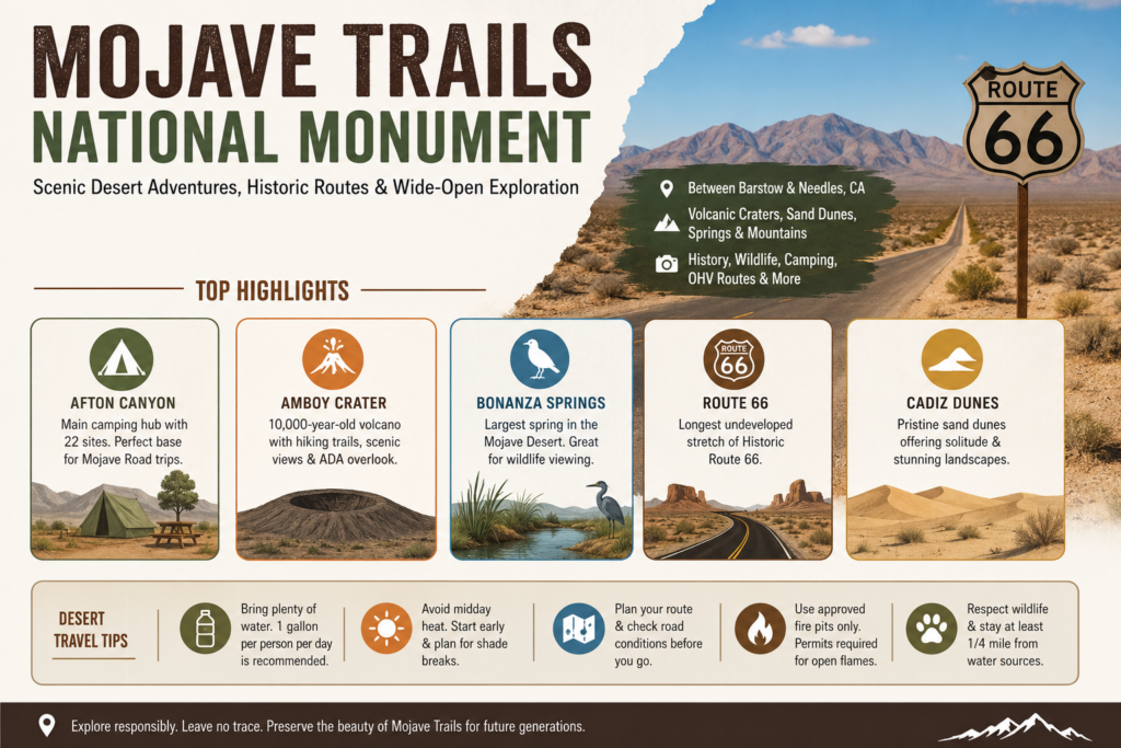
Mojave Trails National Monument is one of Southern California’s most remarkable desert landscapes, where Route 66 history, volcanic scenery, camping, wildlife, and wide-open public land all come together. Stretching across a vast corridor between Barstow and Needles, the monument offers travelers a rare mix of adventure, quiet, and cultural heritage. Whether you want to camp at Afton Canyon, hike Amboy Crater, follow Historic Route 66, or simply take in the desert views, this guide will help you plan a safe and rewarding visit.
What Mojave Trails National Monument Is
At its core, Mojave Trails National Monument is a conservation landscape and recreation landscape managed by the Bureau of Land Management. It was established on February 12, 2016, and its purpose reflects a modern public-land balance: protect key natural and cultural resources while still allowing traditional and recreational use on appropriate routes and in designated areas. The monument includes rugged mountain ranges, broad desert basins, ancient lava fields, dunes, dry washes, wildlife habitat, historic roads, and archaeological and cultural resources that span thousands of years of human presence.
That mix is what makes the monument distinctive. It is not a tidy national park with a single entrance, one visitor center, and a neatly packaged loop. Instead, it is a layered desert region where each major stop highlights a different dimension of the landscape. Afton Canyon is the camping and route-planning anchor. Amboy Crater is the geological centerpiece. Bonanza Springs is the wildlife stop. Route 66 is the historic corridor that gives the region cultural continuity. The Mojave Road is the adventure route that pulls everything together for overlanders, explorers, and slow travelers. The result is a destination with depth, range, and character.
Location and Geography
Mojave Trails National Monument sits in California’s Mojave Desert between Barstow and Needles. This east-west corridor is important because it links two well-known desert destinations and creates a broad passage of protected public land in between. The BLM explains that the monument connects Mojave National Preserve and Joshua Tree National Park, and that connection is not just symbolic. It helps support ecological movement, historic travel routes, and the preservation of open desert space across a large and varied region.
The geography is diverse enough to reward repeat visits. You will find volcanic features, rocky mountain fronts, sandy expanses, broad valleys, dry alluvial fans, and quiet basins. This is not a one-landform destination. It is a mosaic of desert environments, each with its own mood and use. Some areas feel stark and exposed. Some feel sheltered and intimate. Some are ideal for driving. Some are better for hiking. Some are rich in history. Others are rich in silence.
For travelers, geography is not an abstract concept here. It shapes the trip itself. Barstow is a practical western gateway, especially if you are heading toward Afton Canyon or exploring the Route 66 side of the monument. Needles is a useful eastern gateway for visitors approaching from Arizona or the lower Colorado River region. Twentynine Palms is another helpful base because it gives access to several monument highlights within a day’s drive. That is why most visitors do better choosing a focused route rather than trying to cover everything at once. This landscape rewards pacing.
Main places to know before you go
| Place | Why it matters | Best for | Key note |
| Afton Canyon | Main camping base and route hub | Camping, Mojave Road trips | The BLM says the access road is generally passable by passenger cars until the campground. |
| Amboy Crater | Signature geology stop | Hiking, photography, Route 66 | Visit 29 Palms describes it as a 10,000-year-old volcano with visitor amenities and an ADA overlook. |
| Bonanza Springs | Wildlife-focused stop | Wildlife viewing, quiet travel | Visit 29 Palms calls it the largest spring in the Mojave Desert. |
| Route 66 corridor | Historic travel spine | Scenic driving, heritage travel | The BLM says it contains the longest remaining undeveloped stretch of Route 66. |
| Cadiz Dunes Wilderness | Major dune landscape | Solitude, scenery | Visit 29 Palms describes it as pristine sand-dune country in the monument. |
Climate and Weather Patterns
The Mojave Desert is a true desert environment, but it is not static or simple. The region experiences dramatic daily temperature swings, intense summer heat, cold winter nights at higher elevations, low humidity, and periodic wind events that can transform a calm day into a difficult one. USGS descriptions of the Mojave emphasize that Precipitation is limited, seasonal, and unevenly distributed, with most moisture arriving during cooler months. Summer thunderstorms are possible, too, and when they do occur, they can create sudden flooding in dry washes and dramatic changes in road conditions.
For travelers, this means timing matters. Fall, winter, and spring are usually the most comfortable seasons for hiking, camping, and scenic driving. These are the months when the landscape is more forgiving,g and the temperatures are less punishing. Summer travel is still possible, but it requires a more deliberate strategy: early starts, high water reserves, shaded breaks, route awareness, and a willingness to adjust plans if heat or weather becomes dangerous.
The BLM’s safety guidance emphasizes planning, checking local conditions, and treating the desert as a self-sufficient environment. In practical terms, that means you should not rely on frequent cell service, nearby services, or last-minute improvisation. The desert does not reward casual assumptions. It rewards preparation, patience, and situational awareness.
The Best Stops in Mojave Trails National Monument
The most satisfying visits to Mojave Trails National Monument usually combine several kinds of experience: one heritage stop, one geological landmark, one outdoor activity, and one scenic route. The monument is large enough to support all of that, but the trick is not trying to do everything in a single rushed day. Instead, build a trip around a few anchor destinations and let the rest of the landscape unfold naturally.
Afton Canyon
Afton Canyon is often the most useful first stop for new visitors because it works as both a campground and a route hub. The BLM identifies it as a developed recreation site with 22 primitive campsites, each featuring a shade structure, parking area, picnic table, fire pit, and grill. Sites are first-come, cost $6 per night, and carry a 14-day stay limit. The campground is also a logical starting or ending point for a Mojave Road trip and a convenient midpoint for travelers moving between Las Vegas and Los Angeles.
What makes Afton Canyon especially valuable is that it provides structure inside a landscape that is otherwise very open and remote. Visitors still need to come prepared, but the campground reduces some of the uncertainty that comes with wilderness-style desert travel. The BLM also warns that strong winds, flash floods, limited cell coverage, and wildlife hazards are part of the area’s normal conditions. This is not a place to arrive underprepared.
Fire rules are also strict and important. Campfires are allowed only in approved fire pits and grills. Rock-ring fires are not permitted. Controlled-flame devices require a California campfire permit. These rules matter because the desert is fragile, fire-sensitive, and highly exposed to damage from careless use. Afton Canyon is one of the most practical and accessible places to camp in the monument, but it is still a real desert setting, not a convenience campground.
Amboy Crater
Amboy Crater is one of the monument’s most iconic landmarks and one of its most photogenic stops. Visit 29 Palms describes it as a 10,000-year-old volcanic crater near the original Route 66 alignment, and that combination of geology and road history gives the site special appeal. It is not just a scenic pullout. It is a landform that helps visitors understand the volcanic origin of parts of the Mojave landscape.
The site includes a paved access road, parking, shade ramadas, picnic tables, vault toilets, an interpretive kiosk, and an accessible viewing platform. Those features make it an excellent stop for families, casual travelers, geology enthusiasts, and photographers. It is also a useful reminder that desert travel does not have to be extreme to be rewarding. Sometimes one memorable landform is enough.
Timing is the key to enjoying Amboy Crater well. Visit 29 Palms notes that the dark basaltic rock absorbs and reflects heat, making the site especially challenging during warmer months. Late fall through early spring is usually the best period for a hike or longer stop. That advice holds for much of the monument. In the desert, shade, temperature, and daylight length are not minor details. They are trip-defining factors.
Bonanza Springs
Bonanza Springs offers a completely different kind of experience. Instead of volcanic terrain or campground infrastructure, it presents water, vegetation, and wildlife in a landscape where those elements are often scarce. Visit 29 Palms identifies it as a major wildlife viewing area in the foothills of the Clipper Mountains and says it is fed by the Fenner Basin aquifer. It is also described as the largest spring in the Mojave Desert.
That matters because springs in desert environments are ecological lifelines. They support mesquite, cottonwood, cattails, birds, insects, reptiles, and mammals that depend on a reliable water source. Bonanza Springs is a reminder that the Mojave is not empty. It is selective. Life concentrates where conditions allow it. Visitors should treat such places with care, patience, and quiet observation.
Route 66
For many travelers, Route 66 is the emotional and symbolic heart of the monument. The BLM says Mojave Trails National Monument contains the longest remaining undeveloped stretch of Route 66, and Visit 29 Palms reinforces that point while framing the road as a major scenic and heritage travel corridor. That gives the monument a rare kind of appeal: it is both a historic roadway and an intact desert landscape.
The power of this experience is not only nostalgic. Yes, Route 66 carries all the cultural memory of road trips, westward movement, and American highway mythology. But in Mojave Trails, it also remains embedded in a real landscape that still feels open, raw, and expansive. Long sight lines, old alignments, scattered historic remnants, and broad desert horizons make the route feel less like a museum piece and more like an active corridor through time. For SEO purposes, Route 66 is one of the strongest naturally recurring terms in any article about this monument because it connects history, travel, photography, and landscape all at once.
Mojave Road
The Mojave Road is the monument’s adventure spine. Visit 29 Palms describes it as a 138-mile historic route that crosses the desert through a chain of watering points, and the BLM has also identified the monument as a destination for Jeep touring and overlanding. That makes the route especially attractive to travelers who enjoy planning, navigation, and the slow discovery of remote country.
This is not a route for spontaneity alone. Good maps, reliable water, a vehicle suited to the conditions, and a calm pace are essential. The Mojave Road rewards travelers who understand that the journey itself is the destination. It is less about speed and more about reading the land: where water once existed, where movement was possible, where people traveled, and how the desert still guides passage today.
Cadiz Dunes Wilderness
The Cadiz Dunes Wilderness adds a softer, more open, more wind-shaped side of the monument. Visit 29 Palms describes it as pristine sand-dune country east of Twentynine Palms and notes that the route to the dunes passes through some of the monument’s most beautiful terrain. This area helps broaden the visitor’s understanding of Mojave Trails because the monument is not just mountains and rock. It is also sand, texture, motion, and quiet expanse.
Dunes create a different kind of desert experience. They feel less rigid than lava fields or canyon walls, and they often invite reflection, photography, and slow walking. In the Cadiz area, the landscape can feel especially remote and visually expansive, which makes it ideal for travelers seeking solitude.
Rockhounding Areas
Rockhounding adds another layer of appeal to the monument. Visit 29 Palms says collecting rocks and invertebrate fossils has been popular in the region for more than a century, especially around the Marble Mountains and Trilobite Wilderness. That gives the monument a strong experiential dimension for visitors who prefer hands-on exploration rather than passive sightseeing.
This is also where responsible travel becomes especially important. Casual-use collection is not the same as unlimited collection, and visitors need to follow BLM rules carefully. The point is not to strip the desert of its treasures. It is to appreciate its geologic history, observe it respectfully, and collect only where and when allowed. In a place as old and layered as Mojave Trails, restraint is part of the experience.
Climate, Plants, and Desert Life
The plant life of the Mojave is built on adaptation, endurance, and seasonal timing. Desert shrubs, cacti, annual wildflowers, and drought-tolerant trees all use different strategies to survive in a place where water is scarce, and temperature shifts can be extreme. The Nature Conservancy describes the desert as both biologically rich and ecologically fragile, which is a helpful way to understand the region. It may appear bare at first glance, but it supports a surprisingly diverse living system underneath that apparent simplicity.
The desert also changes dramatically after rainfall. When conditions are favorable, the ground can green up, flowers can appear, and wildlife activity can increase. In drier periods, the same terrain may look austere, still, and almost monochrome. That seasonal variation is part of the appeal. It means the Mojave is not a fixed postcard. It is a changing system with rhythms of dormancy and renewal.
For visitors, this means plant life is worth noticing, not overlooking. Vegetation often marks drainage patterns, springs, and sheltered spaces. It also helps reveal how life organizes itself in harsh terrain. The more you look, the more you realize the desert is structured by water even when water is not visible.
Wildlife in Mojave Trails National Monument
Wildlife is one of the most underappreciated strengths of Mojave Trails National Monument. The broader Mojave Desert supports birds, reptiles, mammals, insects, and amphibians that have adapted to limited water and intense environmental stress. The Nature Conservancy emphasizes that the desert contains a wide variety of living things, while the BLM reminds visitors not to disturb animals around sensitive water sources like Afton Canyon.
One of the best-known species in the region is the desert tortoise, a threatened species often used as a symbol of Mojave conservation. Even if you never see one in person, its presence matters because it helps explain why habitat protection, route discipline, and low-impact recreation are central to the monument’s management. This is not just about scenic access. It is also about coexistence.
Wildlife viewing in the monument is best approached as patient observation rather than active pursuit. Move quietly. Keep your distance. Do not approach animals, especially near water. Watch for tracks, bird activity, and signs of movement near springs, washes, and shaded areas. The desert often appears still until you begin noticing how much life it actually supports.
Human History and Cultural Layers
The human history of Mojave Trails National Monument is deep, complex, and essential to understanding the place. Visit 29 Palms says the area contains evidence of more than 10,000 years of human occupation and identifies the Mojave Indian Trail as the earliest known route through the region. The monument also lies within a broader network of cultural and trade connections associated with the Chemehuevi, Shoshone, Serrano, Kawaiisu, and Paiute peoples.
This matters because it shifts the monument’s identity from “scenic desert” to “living cultural corridor.” Long before modern highways or recreational vehicle travel, people moved across this landscape, located water, exchanged goods, and followed routes that connected communities and ecosystems. The land was never empty. It was traversed, known, and used in specific ways for thousands of years.
The later historical layers are equally meaningful. The BLM says the monument includes some of the best-preserved Desert Training Center sites from the World War II era. Visit 29 Palms adds that the region preserves Native American trade routes, military history, and Route 66 heritage together. That combination makes the monument unusually rich. Few desert landscapes contain such a direct overlap of ancient travel, wartime preparation, and modern recreation.
The BLM managers’ report also shows that the monument remains a live and active destination. Visitors hike Amboy Crater, drive Historic Route 66, and increasingly use the area for Jeep touring and overlanding. The report also notes that Afton Canyon is the only developed overnight campground in the monument, which makes it strategically important for trip planning. History here is not a separate category. It is embedded in how people still use the land.
Camping in Mojave Trails National Monument
Camping is one of the strongest reasons people search for the Mojave Trails National Monument, and for good reason. The BLM says Afton Canyon Campground is the only developed overnight campground inside the monument. It offers 22 developed campsites plus a group campsite, and each site includes basic features such as a picnic table, shade structure, restrooms, and trash receptacles. The campground is especially useful because the access road is generally passable by passenger vehicles up to that point, although high-clearance 4×4 vehicles are required beyond it.
That makes Afton Canyon the most straightforward overnight option for most visitors. It is accessible, structured, and clearly managed. But the monument also offers dispersed camping on most BLM lands, except within the Afton Canyon ACEC and the main Amboy Crater parking area. The BLM states that dispersed campers may stay in one site for up to 14 days, then must move at least 25 miles away. Camps should be placed at least one-quarter mile from wildlife water sources, and previously disturbed sites are preferred. No permit or fee is required for dispersed camping on general BLM lands.
The practical takeaway is simple. If you want a reliable, easier overnight stay, choose Afton Canyon. If you want more solitude and understand the rules, dispersed camping may be a better fit. Either way, the desert demands self-reliance. There is no substitute for carrying enough water, food, fuel, navigation tools, and emergency supplies. Camping here is not about convenience. It is about thoughtful, low-impact access to a remarkable landscape.
Travel Safety Tips for the Desert
Desert travel can be unforgettable, but it can also be unforgiving. The BLM consistently emphasizes preparation because the conditions in the Mojave Trails National Monument can shift quickly. Heat, wind, flash floods, poor cell coverage, rough roads, and wildlife are all normal features of the environment. These are not rare surprises. They are part of the operating conditions of the region.
Water is the most critical item. The BLM advises at least one gallon of water per person per day, and that minimum should be treated as a starting point, not a luxury. Sun protection, route planning, and realistic time management are equally important. Avoid the hottest part of the day for hiking. Start early. Built-in rest. Know where you are going, how long it should take, and what your backup plan is if something changes.
Flash floods deserve special attention. Dry washes may look harmless, but they can become dangerous rapidly during storm events. Strong winds can also make driving and camping more difficult than expected. If the weather is uncertain, the safest decision is often to delay, reroute, or shorten the outing. The desert is still beautiful when you adapt to it; it becomes much less beautiful when you fight it.
Fire safety is another major issue. Approved pits and grills are the only acceptable campfire locations in developed sites like Afton Canyon. Rock-ring fires are not allowed. Controlled-flame devices require a California campfire permit. These rules are not bureaucratic extras. They protect the landscape, reduce wildfire risk, and preserve the visitor experience for everyone else.
Best Things To Do in Mojave Trails National Monument
The best experiences in Mojave Trails National Monument usually combine history, scenery, and one focused outdoor activity. One highly effective first visit would include Afton Canyon for camping, Amboy Crater for geology and photography, and a stretch of Historic Route 66 for the heritage driving experience. That combination captures the monument’s identity without forcing you into an exhausting itinerary.
You can also shape the trip around a specific interest. History-focused travelers may spend more time on Route 66 and Desert Training Center sites. Hikers can concentrate on Amboy Crater and nearby desert walks. Wildlife enthusiasts may gravitate toward Bonanza Springs and quieter corridors. OHV users and overlanders can focus on the Mojave Road and designated routes. The monument is broad enough to support all of these approaches.
Simple trip ideas
| Trip style | Simple plan | Best stops |
| One-day scenic trip | Drive a Route 66 segment, stop at Amboy Crater, and finish with sunset photos. | Amboy Crater, Route 66, roadside viewpoints |
| Camping weekend | Base at Afton Canyon, explore part of the Mojave Road, and return for a second day. | Afton Canyon, Mojave Road, scenic dirt routes |
| Wildlife and solitude trip | Visit Bonanza Springs and quieter corridors with minimal stops. | Bonanza Springs, designated roads, open viewpoints |
Environmental Issues and Conservation
The Mojave may seem vast, but it is not invulnerable. The Nature Conservancy describes the desert as finite and fragile, despite its richness. That is a crucial point. Open space is not the same as unlimited resilience. Every vehicle track, campfire, roadside stop, and footpath has the potential to affect habitat, water sources, and sensitive landforms.
That is why conservation is part of the visitor experience, not separate from it. Staying on designated routes helps protect resources. Keeping a respectful distance from springs and wildlife reduces stress on animals. Packing out trash preserves the sense of remoteness that draws people in the first place. Responsible behavior is not just ethical here. It is practical.
The BLM’s management approach reflects this balance. Mojave Trails National Monument exists to protect biological connectivity and historic resources while still allowing recreation and traditional use. That is a classic multiple-use public-land model, but it depends on visitor cooperation. The rules around camping, fire use, and route access are there to preserve the qualities that make the monument worth visiting.
Pros and Cons
Pros
The monument offers huge, varied desert scenery. Mountains, lava fields, dunes, open valleys, and wilderness all appear in one place.
It supports a wide range of activities. Camping, history, hiking, OHV travel, rockhounding, scenic driving, and wildlife viewing all fit naturally here.
The Route 66 connection is unusually strong. Few landscapes combine road history and intact desert scenery this well.
Afton Canyon gives the monument a practical overnight base. That makes trip planning easier than it would be in a fully undeveloped desert.
Cons
The area is remote. Self-sufficiency is not optional.
Heat can be severe. Summer travel requires discipline and planning.
Some routes need higher-clearance vehicles or 4×4 capability.
Rules are specific and must be followed carefully, especially for camping and fire use.
FAQs
Yes. The BLM allows developed camping at Afton Canyon and dispersed camping on most BLM lands in the monument, with rules for stay length, distance from wildlife water sources, and site selection.
Yes. The BLM says the monument contains the longest remaining undeveloped stretch of Route 66, and Visit 29 Palms connects the monument directly with the historic Route 66 experience.
Not for every stop, but many unpaved routes are easier and safer with high clearance. The BLM says the access road is generally passable by passenger cars to Afton Canyon Campground, but high-clearance 4x4s are required beyond that point.
For most first-timers, Afton Canyon and Amboy Crater are the best pair. One provides camping and route logistics, and the other gives you a clear geological landmark with visitor facilities.
Yes, but only on designated routes and with proper preparation. The BLM emphasizes route awareness, self-reliance, and caution because the monument is remote and conditions can be demanding.
Conclusion
Mojave Trails National Monument is more than a desert drive. It is a place where history, geology, and outdoor recreation meet in one Unforgettable landscape. With the right preparation, you can enjoy camping, scenic routes, wildlife viewing, and iconic landmarks while traveling responsibly through this fragile environment. For first-time visitors and repeat explorers alike, Mojave Trails offers a true desert experience that is both rugged and rewarding.