Introduction
A Mojave Desert Map helps you understand one of the most important desert regions in the southwestern United States. It shows where the desert lies, how its boundaries shift, and which roads, towns, parks, and landmarks matter most. Because the Mojave covers a vast and varied landscape, a good map is essential for both learning and travel planning.
Why the Mojave Desert map matters
The Mojave Desert is one of those places that can seem straightforward on a screen but much more complex on the ground. On a map, it may look like a broad tan region with a few labeled parks and highways. In reality, it contains dry basins, rugged ridges, volcanic terrain, open desert flats, valley corridors, and long stretches where services are sparse, and distances are deceptive. That contrast is exactly why mapping the region matters.
A well-built Mojave Desert map helps you answer the questions that matter most before you travel or study the area. Where are the main protected lands? Which roads are paved, and which are rough or remote? What towns offer fuel, lodging, or food? Which parks are close together, and which are separated by long desert drives? What areas are suitable for scenic exploration, and which areas are better left to experienced backcountry travelers? In a region this large and this dry, those questions are not minor details. They are the difference between a smooth trip and a frustrating one.
The map also matters because the Mojave is a region where geography, ecology, and travel intersect. Providing you are studying the landscape, the map helps you understand basin-and-range structure, vegetation zones, and ecological transitions. If you are driving, it helps you see the highway network, access roads, and visitor hubs. If you are exploring parks, it helps you connect trails, scenic overlooks, and backcountry destinations. In other words, the map is both a learning tool and a survival tool.
For many visitors, the easiest way to understand the Mojave is to anchor it around a few major names: Death Valley National Park, Joshua Tree National Park, Mojave National Preserve, and Mojave Trails National Monument. Those places do more than mark points on a map. They reveal the entire character of the region, from extreme heat and salt basins to Joshua tree woodlands, lava beds, dunes, and historic travel corridors. Once you understand those anchors, the rest of the Mojave becomes much easier to read.
Where the Mojave Desert is located
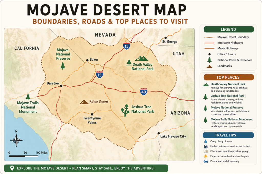
The Mojave Desert sits in the southwestern United States and spans a wide sweep of land across four states. Most commonly, it is described as covering parts of southern California and southern Nevada, with additional portions extending into southwestern Utah and northwestern Arizona. That multi-state footprint is one reason different sources may present the Mojave in slightly different ways. A state road atlas, a geological survey, a national park brochure, and a conservation map may all emphasize different edges of the same region.
The Mojave is not defined by one simple political boundary. Its limits are shaped by climate, elevation, landforms, and vegetation. This is why the desert often fades into neighboring areas instead of stopping abruptly like a county line or state line. On one side, you may move from the low desert into the foothills or mountain zones. On the other hand, the transition may be gradual, with plant communities shifting little by little rather than changing all at once. That transition zone is part of the Mojave story, too.
Another useful way to picture the Mojave is to see it as a desert network rather than a single blank expanse. The region is linked by highways, historic routes, protected lands, wildlife habitat, and gateway communities. That network structure is what makes the map so valuable. It reveals how people actually move through the desert, where services are located, and how landforms shape both travel and ecology.
Which Mojave Desert map should you trust?
Not every Mojave map is built for the same purpose. Some are best for research, others for road trips, and others for park visits. The smart move is to match the map to the task.
| Map type | Best for | What it shows | Why it matters |
| Ecological map | Geography and boundaries | Desert extent, vegetation patterns, transition zones | Useful when you want to understand the Mojave as a natural region rather than a political one |
| Park map | Visiting a protected area | Entrances, trails, viewpoints, roads, services | Best for on-the-ground navigation inside a park or preserve |
| Road-condition map | Travel safety | Closures, detours, washes, and current route status | Critical in the desert, where roads can change quickly after storms |
| Regional travel map | Trip planning | Towns, highways, parks, and major landmarks | Helps connect the desert to real-world driving routes and services |
The most reliable Mojave Desert map is not necessarily the prettiest or most colorful one. It is the one that fits your purpose. Whether you are studying ecology, choose a map that shows habitat and transition zones. If you are planning to drive, use an official park map and live road updates. If you are building an itinerary, combine a regional travel map with a park brochure map. That layered approach gives you the clearest picture.
Boundaries: why the Mojave edges look different on different maps
One of the most confusing things about the Mojave Desert map is that its boundaries do not always look exactly the same from one source to another. That does not mean the maps are wrong. It means they are serving different goals.
A conservation map may draw boundaries around vegetation communities or habitat zones. A travel map may include more of the surrounding road network and service corridors. A park management map may focus on visitor areas and Protected units. A classroom atlas may simplify the region to make it easy to understand at a glance. Each version is a simplified model of reality, not reality itself.
This is why it helps to think of the Mojave as a landscape with soft margins. Its identity is clear on the ground, but its outline on paper is always a little approximate. The real value is in seeing the zone around the edge, not just the edge itself. That broader transition area is where the Mojave meets neighboring ecological systems, and that is where many of the desert’s most interesting geographic patterns appear.
Joshua Tree National Park is a perfect example. The park contains two distinct desert ecosystems, the Mojave and the Colorado, meeting in one place. That overlap makes it a boundary zone rather than a clean-cut one-desert landscape. It is a strong reminder that desert maps are often about transition, complexity, and overlap rather than neat separation.
Cities and gateway towns on the Mojave Desert map
A practical Mojave Desert map should include the towns that function as entry points, supply points, and access hubs. In a desert region, gateway towns are not minor labels. They are essential reference points.
Barstow, Baker, and Twentynine Palms are especially important. Barstow is a key logistics and access center for the western Mojave. Baker serves as a major approach point for travelers heading toward Mojave National Preserve. Twentynine Palms is closely associated with Joshua Tree National Park and provides one of the most recognizable access points for visitors. These towns help organize the desert into routes, stops, and service corridors.
Gateway towns matter because the Mojave is not built around dense urban clusters. It is built around distance, access, and connection. A map that shows the desert without towns may look clean, but it is not very useful for real travel. The towns tell you where to refuel, where to rest, where to buy supplies, and where to turn off the highway before entering more isolated terrain. That is why a good travel map should always combine natural features with human infrastructure.
The broader desert also connects to major road networks in southern California and nearby Nevada. Historic corridors, scenic byways, and long-haul desert roads all pass through or near the region. This makes the Mojave particularly appealing for road trips, heritage travel, and cross-country desert exploration.
Roads and highways that matter most
Roads are one of the most important elements on any Mojave Desert map. In a region this large and remote, roads are not just lines. They are lifelines. They determine whether a place is accessible, whether a route is efficient, and whether a scenic drive is manageable or risky.
In Mojave National Preserve, several roads are especially significant: I-15, I-40, Kelbaker Road, Cima Road, Nipton Road, Essex Road, and Goffs Road. These are the routes that shape travel through the preserve and connect it to nearby towns, highways, and landmarks. Some are primary access roads, while others are more remote connectors. Together, they form the preserve’s internal and external circulation pattern.
Road conditions in desert country can change quickly. Weather can damage surfaces, washes can cut across routes, and remote segments may be rough even when they appear straightforward on a map. That is why official road pages matter so much. A third-party navigation app may show a route as open long after a storm has altered it. In a desert setting, this can create delays or safety problems. The road on the map and the road on the ground are not always the same thing.
A strong Mojave travel map should help you read distance intelligently. The gap between towns may seem short on the screen, but the actual drive can be much slower than expected if the route is unpaved, under repair, or exposed to weather impact. That is why the best desert travelers plan by time, surface type, and service availability rather than by mileage alone.
Road tips that belong on every Mojave travel map
Check official road conditions before leaving.
Carry a paper map as a backup.
Do not rely on GPS alone in remote desert zones.
Expect washboards, potholes, sand, and storm damage.
Build extra time into every desert drive.
Parks, preserves, monuments, and landmarks
The Mojave Desert map becomes much more meaningful when you connect it to the major protected areas that define the region. Three of the biggest anchors are Death Valley National Park, Joshua Tree National Park, and Mojave National Preserve. A fourth important feature is the Mojave Trails National Monument. Together, these places show the desert’s range, depth, and diversity.
Death Valley is the end of the spectrum. It is famous for severe heat, dry basins, salt flats, towering peaks, and some of the most dramatic landforms in North America. On a map, it is one of the most distinctive and memorable places in the entire Mojave. It helps explain why the desert has such a powerful reputation.
Joshua Tree National Park offers a different face of the desert. It combines iconic trees, giant boulders, wildlife habitat, dark skies, and striking geologic formations. It is one of the best examples of how desert ecosystems can be surprisingly rich and visually distinctive. On a map, it also shows the importance of ecological overlap, because two desert systems meet there.
Mojave National Preserve is a place where map reading becomes especially important. It is large, remote, and crossed by multiple routes with different levels of accessibility. Visitors need official maps and updated road information because conditions can shift. The preserve shows why the desert should never be approached casually with a generic app alone.
Mojave Trails National Monument adds a broad regional dimension. It includes a huge landscape with historic travel routes, rugged mountains, dunes, and volcanic terrain. It is especially helpful for understanding the western and central Mojave on a bigger scale. If you are building a comprehensive understanding of the desert, it belongs on the map.
Climate and weather patterns on the map
The Mojave is a desert, but that does not mean its weather is simple. In fact, one of the most important things a map can help you understand is how climate shapes travel, habitat, and seasonal planning.
The region is known for intense heat, low rainfall, and large day-to-night temperature swings. Summer can be brutally hot, while winter nights can become surprisingly cold. In many desert areas, precipitation is low and uneven, with rainfall often concentrated in certain seasons or linked to storm events. In some locations, sudden thunderstorms can produce flash floods even when the land has been dry for long periods.
Death Valley is the most dramatic example of Mojave climate extremes. It is widely associated with record heat and very low rainfall, and it illustrates how severe desert conditions can become. But the climate story does not end there. Joshua Tree and other Mojave areas also show how temperature, moisture, and drought influence plant communities, wildlife behavior, and fire risk.
Climate change adds another layer. The Mojave is not a frozen-in-time landscape. Some areas are getting hotter and drier over time, and those changes affect water availability, vegetation health, wildlife movement, and human safety. That is one more reason a Mojave Desert map should be read together with weather forecasts, seasonal patterns, and current road reports.
Landscape features: dunes, rocks, valleys, salt flats, and lava
The Mojave Desert is not a flat field of sand. That is one of the biggest misconceptions people bring to the map. In reality, the region is a mosaic of landforms: mountains, basins, dunes, cliffs, dry lakes, rocky slopes, badlands, and lava fields. This variety is what gives the Mojave its character.
The basin-and-range structure of the region means that mountain chains and wide lowlands alternate across the landscape. That creates dramatic elevation changes over relatively short distances. A route that looks simple on paper may cross multiple landforms, each with its own surface conditions and visual identity. That is one reason the Mojave map feels so layered.
Death Valley offers the clearest example of this variety. It contains below-sea-level basins, peaks, canyons, salt flats, colorful hills, and dune systems. Each of those features can influence travel and exploration differently. A visitor map should not only show the name of the park; it should help you understand the internal geography of the park itself.
The Mojave also contains volcanic terrain, including lava beds and cinder cones. These features are important because they show that the desert is geologically active in its own old and powerful way. When you see these features on a map, you are seeing more than scenery. You are seeing the deep structure of the land.
Flora: plants of the Mojave Desert map
Plants are one of the best ways to understand the Mojave. Even though the desert is dry, it is not barren. The plant life is adapted, resilient, and ecologically important. A good Mojave Desert map should therefore be read as a vegetation map as much as a travel map.
The region supports shrubs, grasses, forbs, succulents, and specialized desert plants that have learned to survive in harsh conditions. Creosote bush, blackbrush, cacti, and wildflower communities are all part of the broader plant mosaic. At higher elevations or in different ecological zones, the vegetation can shift toward pinyon pine, juniper, and other species that are more typical of cooler or slightly moister environments.
Joshua Tree National Park is one of the clearest examples of plant richness in the Mojave. It contains an unusually diverse plant community for a desert environment, and that diversity changes with elevation, soil, and exposure. The iconic Joshua tree itself is only one part of the story. The park also contains many annuals, shrubs, and other species that define seasonal color and habitat structure.
Native plants are not only visually important. They are essential for habitat stability, erosion control, food webs, and restoration work. In conservation terms, the vegetation on a Mojave map tells you where ecosystems are healthy, where they are stressed, and where recovery work may be needed. That makes plant communities one of the most important layers of the map.
Fauna: wildlife, reptiles, birds, and mammals
The Mojave may look austere at first glance, but it supports a surprisingly rich animal community. A strong map of the region should therefore be read not only in terms of roads and landforms, but also in terms of habitat and wildlife movement.
Mammals are a major part of the ecosystem. Desert-adapted species like kangaroo rats, ground squirrels, coyotes, foxes, bobcats, mule deer, and bighorn sheep all play a role in the broader biological network. Many of these animals are active at night to avoid heat, which is a perfect example of adaptation to desert life.
Reptiles are especially visible in the Mojave. Lizards, snakes, and desert tortoises are among the region’s best-known reptile inhabitants. These animals depend on specific habitat conditions, including soil type, native vegetation, and shelter opportunities. That means habitat mapping matters a great deal. A good Mojave Desert map can help explain why some species appear in one zone and not another.
Birdlife is another major part of the region’s ecological identity. The desert may seem quiet, but it is used by a wide variety of birds, including resident species and seasonal migrants. Some areas of the Mojave function as important migration corridors, which gives the region even more ecological significance. A map that shows habitat and water sources can help explain why birds concentrate in certain areas.
Human history and cultures
The Mojave Desert has a long and deep human history. It has never been empty, even when it appears empty on a modern map. People have lived, moved through, hunted in, traded across, and adapted to the desert for thousands of years.
Indigenous peoples are central to that story. Communities such as the Mojave and Chemehuevi, along with others in the region, shaped travel routes, resource use, and cultural patterns long before modern highways or visitor centers existed. The desert was not a void; it was a lived-in, traversed, and understood landscape. Trails connected water, shelter, trade, and seasonal movement. Those historic networks still influence the way the region is read today.
Later, explorers, settlers, miners, ranchers, and transportation systems changed how the desert was used and mapped. Historic travel routes became wagon roads, then highways, then scenic corridors. Mining camps, rail-linked communities, and military routes also left their mark. In many cases, the modern road network still echoes older patterns of movement.
That layered human history is another reason the Mojave Desert map is so compelling. It is not just a geography chart. It is also a cultural archive. Roads, cabins, rock art, ruins, and preserved route segments all tell part of the same story: the desert has always been part of human life, not apart from it.
Travel tips: how to use the map safely
A Mojave travel map is most useful when it helps you avoid common desert mistakes. The first rule is to check current road conditions before departure. Desert routes can be affected by storms, washouts, maintenance, and changing surface conditions. A road that was open yesterday may not be the best choice today.
The second rule is to carry a backup map. Phones are convenient, but desert travel is not always convenient. Battery failure, weak signal, and app inaccuracies are all possible. A paper map is still an excellent backup, and an official brochure map often gives you a much better sense of the region than a tiny phone screen.
The third rule is to think in terms of real distance and real time. On a Mojave Desert map, many places look closer than they are. Sparse services, slow dirt roads, and long stretches without fuel can change the entire rhythm of a trip. Planning only by mileage can be misleading. Planning by route type, access point, and service availability is smarter.
The fourth rule is to prepare for weather variation. The desert can be dangerously hot during the day, cold at night, and vulnerable to flash flooding during storms. A map does not show all of that by itself, so it should always be paired with current weather information and official alerts.
Simple desert travel checklist
Check road conditions before you leave.
Carry water, fuel, food, and a paper map.
Do not trust GPS alone in remote sections.
Expect heat, cold nights, wind, and flash flood risk.
Leave enough time for slow driving and unexpected detours.
Tourism: the best ways to read the map for a trip
For trip planning, the Mojave Desert map should answer four basic questions: Where do I enter? Which roads should I use? Which landmarks are worth stopping for? How far are services from my route? Once you can answer those questions, the map becomes a planning system instead of just a drawing.
For most visitors, the strongest anchor points are Death Valley National Park, Joshua Tree National Park, Mojave National Preserve, and Mojave Trails National Monument. These areas are different enough to create a varied experience. Death Valley delivers extreme desert drama. Joshua Tree offers iconic landscapes and wildlife. Mojave National Preserve gives you a more remote and road-focused desert experience. Mojave Trails adds scenic breadth, heritage value, and open-road atmosphere.
The most efficient trips often combine one gateway town, one main road, one protected area, and one planned exit route. That structure keeps the journey manageable. For example, a traveler can build a route around a town with services, a park entrance, a scenic road, and a return path that avoids unnecessary risk. That way, the map becomes a practical itinerary tool.
The desert is especially rewarding for road-trippers, photographers, hikers, birdwatchers, and travelers interested in American landscape history. But even casual visitors benefit from reading the map carefully. In the Mojave, “close” and “convenient” are not always the same thing. That is why a travel map should be read with patience, not haste.
Interesting facts about the Mojave Desert map
One of the most famous features of the Mojave is Badwater Basin, the lowest point in North America. Another is the historic heat record associated with Furnace Creek, which has made Death Valley one of the best-known extreme environments on the continent. These are not just trivia items; they are map landmarks that help define the region’s identity.
Joshua Tree is equally striking from an ecological perspective. It supports a remarkable number of species for a desert park, including many plants, mammals, reptiles, and birds. That diversity makes the park an ecological hotspot and not just a scenic destination. On a map, it stands out as a place where habitat variety is exceptionally important.
Mojave Trails National Monument adds a different kind of fact value. It preserves a huge landscape and includes major Route 66 heritage, as well as dunes, mountains, and lava fields. That means the map is not only about natural features. It is also about transportation history and cultural memory.
A final fact worth remembering is that the Mojave is changing. Temperature, rainfall, vegetation patterns, and habitat conditions are all under pressure from long-term environmental shifts. So the map is not simply a fixed object. It is a snapshot of a living region in motion.
Environmental issues and conservation
The Mojave faces several environmental challenges at once. Climate change is one of the biggest. As temperatures rise and precipitation patterns shift, the desert’s plants, wildlife, and water sources all feel the strain. Some areas are becoming drier, and that can alter fire behavior, species distribution, and habitat health.
Wildfire is another major issue. Invasive grasses can create fuel where the natural ecosystem is not adapted to burn so readily. That increases the risk of damaging fires, especially in sensitive habitats such as Joshua tree communities. Once those fires spread, recovery can be slow, uneven, and ecologically costly.
Restoration and land protection are, therefore, critical. Native plant work, habitat management, and conservation planning all play a role in keeping the Mojave functioning as a living ecosystem. A map is useful here because it helps people see where protected areas are, where corridors connect, and where ecological pressure may be building.
This is one reason the Mojave Desert map deserves more attention than a casual overview usually gets. That‘s not just a tourist tool. It is also a conservation tool. It helps identify vulnerable zones, protected landscapes, and the human routes that pass through them.
FAQs
The Mojave Desert is in the southwestern United States, mainly across southern California and southern Nevada, with parts extending into southwestern Utah and northwestern Arizona.
The key places are Death Valley National Park, Joshua Tree National Park, Mojave National Preserve, and Mojave Trails National Monument. These places show the desert’s main landforms, roads, ecology, and travel corridors.
No. GPS alone is not a good enough plan in remote desert areas. Official park maps and current road-condition pages are safer because desert roads can change, and third-party apps may not reflect those changes accurately.
Because the Mojave is an ecological region rather than only a political zone, some maps show habitat, some show park boundaries, and some show travel routes. That is why the edges can shift slightly from one map to another.
For Mojave National Preserve, the official brochure map and the current road conditions page are the best starting points. They are designed for visitor safety and real-time trip planning.
Conclusion
The Mojave Desert map is more than a simple outline. It brings together geography, highways, parks, wildlife, climate, and travel access in one view. Whether you are studying the region or planning a trip, the right map makes the Mojave easier to Understand, safer to explore, and more useful to navigate.


