Introduction
The Great Indian Desert (Thar Desert) is a large sun-baked area in the north-west of the Indian subcontinent – a patchwork of dunes, salt pans, rocky expanses, and seasonal green plains that covers mainly Rajasthan and extends to some of Gujarat, Haryana, Punjab, and neighbouring Pakistan. This guide has combined the location, size, climate, plants,s and animals (with the critically endangered Great Indian Bustard) conservation concerns, and practical travel tips into a single publish-ready guide so that the reader can learn in a brief time about what is unique about the Thar and why it is important.
What is the Thar Desert?
In the ecological-information-processing perspective, you may consider the Thar Desert as a vast corpus of nature: a heterogeneous conglomerate of landforms, habitats, human settlements, and time-based weather conditions. Similarly, a text corpus has tokens, sentences, and documents; the Thar has dunes, interdunal plains, saline pans, rocky tracts, ephemeral streams, and villages and towns, each a different kind of token, with its distribution, frequency, and co-occurrence patterns.
Quick facts (a compact vector of top attributes)
- Alternate names: Thar Desert, Great Indian Desert.
- Geographic kernel: northwest Indian subcontinent, primarily Rajasthan.
- Cross-border extent: stretches into Pakistan (Sindh, Punjab).
- Area (scalar ranges): approximately 200,000–264,000 km², depending on the boundary model used.
- Climate class: subtropical desert (low annual precipitation, high seasonal temperature variation).
- Key species of conservation interest: Great Indian Bustard (GIB) — classified as Critically Endangered.
- Tourism anchors: Jaisalmer, Jodhpur, Bikaner.
- Notable protected area: Desert National Park (Jaisalmer district).
Exact location: states and provinces that the Thar Desert spans
If we treat the Thar as a geospatial entity to be tokenized by administrative units, the highest-probability tokens (states/provinces) are:
India
- Rajasthan – the modal state (has the greatest concentration of the number of tokens of desert: dunes, cultural heritage sites, and nature reserves).
- Gujarat – particularly the Rann-fringed and southwestern fringe zones; observe that saltwater sceneries (Rann of Kachchh) can also be enclosed in wider definitions of Thar.
- Small, drier margins and semi-arid patches on the north fringe, which are frequently covered by wider definitions, are Haryana and Punjab.
Pakistan
- Sindh south eastern plain, which changes to the Indus river plain, has some western Thar scenery.
- Punjab (Pakistan) – south eastern regions, which descend into Thar-like conditions.
Why do different maps differ
Forms of the boundary models include: ecologists use vegetation and climatic limits, geologists use substrate and landforms, and political maps use administrative divisions. This way, the eastern border, where Thar becomes the semi-arid Aravalli foothills, and the plains become blurred in comparison to the sharp western border that borders the Indus plain.
How big is the Thar? Area, boundaries & mapping
When you report “how big,” you must choose a mapping model and justify it. Common figures:
- ~200,000 km² — a conservative number often used by general encyclopedias (e.g., Britannica-style sources).
- ~264,000 km² — a broader ecoregion estimate that includes transitional semi-arid zones.
Why the discrepancy matters (decision boundary)
Different studies apply different thresholds for including land as “desert”: e.g., annual precipitation less than 250 mm, vegetation cover below X%, dune dominance, or cultural-land-use patterns. This is similar to machine learning, where different classification thresholds yield different precision/recall trade-offs.
Mapping tips for publishers
- Choose and cite a source (e.g., an ecologist’s ecoregion map vs. a national atlas) and present both numbers as a range if readers require a single figure.
- Use a map card (interactive if possible) that allows toggling between “core desert” and “extended Thar” overlays. This gives readers transparency and improves engagement.
Top landscape features
In an NLP-style ontology, these are the major classes of features in the Thar.
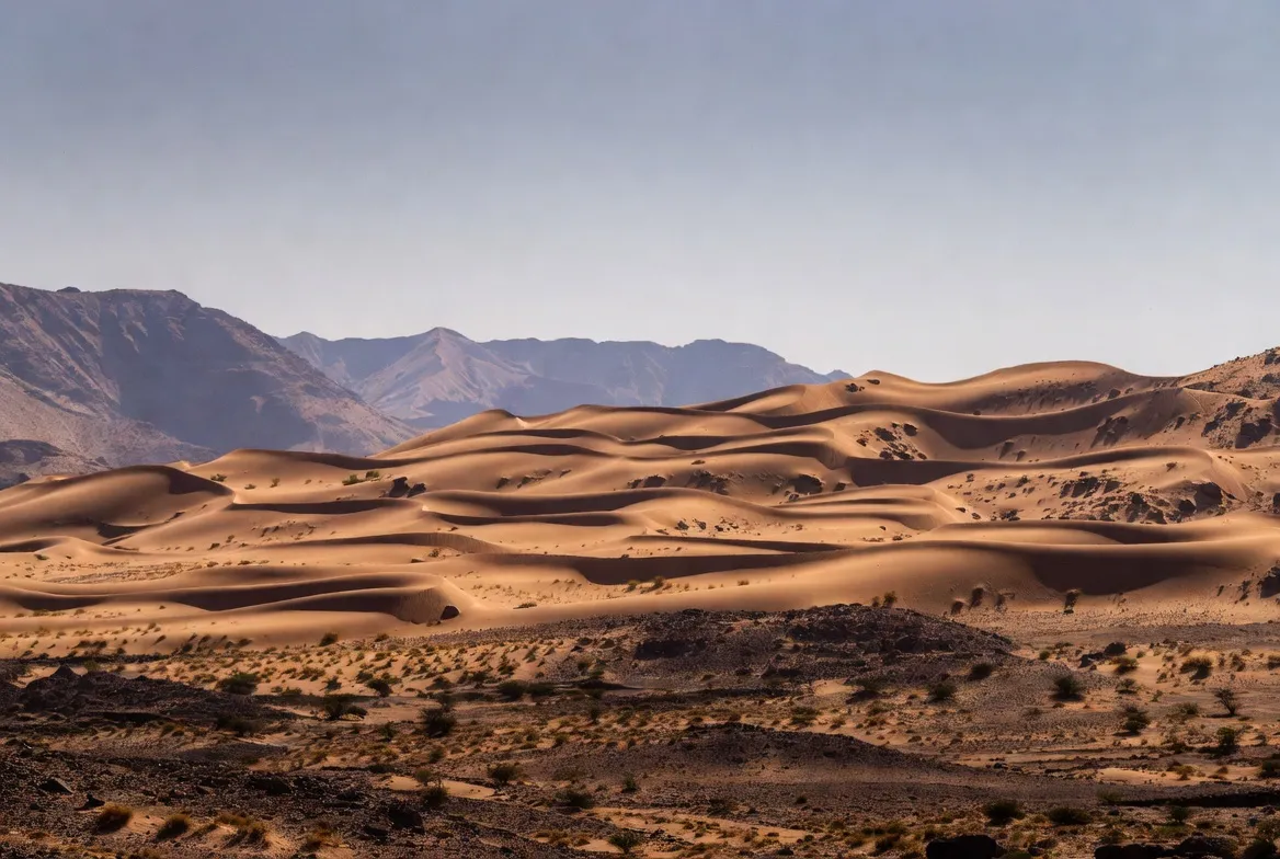
4.1 dunes
High-variance, mobile tokens that produce the visual signature readers expect from a desert. Dune forms vary from crescentic (barchan) to longitudinal and complex star dunes. Famous dune fields near Jaisalmer (Sam, Khuri) are high-engagement features for tourism.
4.2 Interdunal plains
Low-variance tokens: flat zones between dunes that episodically support ephemeral grasses and forbs after rains. Functionally, these zones act like “stop words” — frequent, low-importance,e but structurally necessary to the landscape.
4.3 Salt lakes & pans
Sambhar Lake is a major example of evaporative basins that produce saline crusts and host specialized flora and birds.
4.4 Rocky tracts & plateaus
Eastern Thar and Aravalli-adjacent areas are less sandy and more rocky; these are higher-signal regions for biodiversity and human settlement.
4.5 Ephemeral rivers
Streams like the Luni River are Intermittent but crucial — they function like rare, long-range dependencies in a language model: they connect distant landscape tokens across seasons and support human ecologies.
Climate: seasons and hazards
The Thar’s climate is best described in time-series terms: seasonal pulses driven by the southwest monsoon, a hot-summer peak, and a cool winter trough.
Rainfall
- Primarily during the southwest monsoon (June–September). Highly variable; many locations receive <250 mm/year, especially in western sectors.
- Eastern fringes get somewhat higher rainfall and more regularity.
Temperature
- Summer maxima can exceed 45–50°C in peak months.
- Winter minima sometimes fall near or below freezing at night in some locations.
Hazards
- Sandstorms — pre-monsoon, can reduce visibility and create transport failures.
- Heatwaves — health risks; similar to high outlier values in a dataset that must be clipped for safe analysis.
- Flash floods — occasional intense monsoon bursts causing rapid inundation in ephemeral drains and low-lying settlements.
Seasonal advice
- October–March: recommended for tourism and fieldwork.
- April–June: extreme heat — avoid if possible.
- June–September: monsoon — can be pleasant but also unpredictable; travel logistics may be affected.
Plants and trees
From an ecological lexicon, the Thar’s flora contains drought-tolerant categories: deep-rooted trees that modulate microclimates, thorny shrubs, short perennial grasses, and opportunistic annuals that germinate after rain.
6.1 Key species and functional groups
- Prosopis cineraria (Khejri) — a keystone tree with cultural and ecological importance: fixes nitrogen, provides fodder and shade, and resists drought.
- Acacia spp., Tamarix, Calligonum — thorny shrubs and small trees common on interdunal and rocky soils.
- Grasses (e.g., Cenchrus spp.) — patchily distributed; crucial for grazing species and sustaining small mammals.
- Human-planted vegetation — roadside tree belts and irrigated orchards have reshaped some local vegetation distributions.
6.2 Vegetation patterns and anthropogenic change
Plant cover is highly heterogeneous — reflecting local water availability and land use. Canal irrigation (e.g., areas influenced by the Indira Gandhi Canal) has converted sections into productive farmland, acting like an exogenous feature injection into an otherwise sparse landscape: beneficial for people but potentially harmful to native grassland-dependent species.
Animals and birds (Fauna) — including Great Indian Bustard
Although seemingly inhospitable, the Thar hosts a surprising suite of fauna adapted to aridity. If species were classes in a classifier, many would be in specialized, small-label subclasses with narrow niche occupancy.
7.1 Mammals
- Chinkara (Indian gazelle) — a grace-adapted ungulate of open plains.
- Blackbuck — grassland specialist, locally common in protected pockets.
- Nilgai — generalist, larger-bodied ungulate.
- Desert fox, Indian wolf — predators maintaining trophic dynamics.
- Small mammals — hares, rodents — key prey resources.
7.2 Birds
- Sandgrouse, larks, pipits — small passerines adapted to open scrub.
- Raptors — steppe and tawny eagles, harriers — apex avian predators.
- Vultures and scavengers — important for carcass removal and nutrient cycling.
- Great Indian Bustard (GIB) — a large flighted ground bird, critically endangered.
7.3 Reptiles & invertebrates
- Spiny-tailed lizards (Uromastyx-like taxa), geckos, and varied snakes. Insects and arthropods create the base of the food web.
7.4 Protected areas
- Desert National Park (near Jaisalmer) — conserves desert grasslands, dune ecosystems, and resident fauna, including some GIB individuals. Protected patches are analogous to curated validation sets in ML — small yet crucial for population persistence and monitoring.
The Great Indian Bustard (GIB): Why it matters
The Great Indian Bustard is a conservation flagship: a large ground-dwelling bird dependent on open grasslands and low-rise shrubland. It is Critically Endangered, a label that signals immediate high extinction risk. Threat vectors include habitat loss, collisions with overhead power lines, and disturbance from development (mining, renewable-energy projects). Conservation strategies mirror intervention design in systems engineering: captive-breeding, egg-replacement, carefully managed release trials, and protected-area enforcement are all active “interventions” intended to increase recruitment and survival.
Monitoring and outcomes
Population monitoring uses systematic surveys, call-playback trials, and satellite telemetry on tagged birds — analogous to collecting labeled data and tracking key performance metrics. While there have been promising local increases in small, protected populations, new threats (e.g., infrastructure expansion near release sites) mean the model (i.e., population trajectory) remains fragile and needs ongoing corrective updates.
Human history, culture & major desert cities
People are not anomalous to the Thar — they are part of the landscape’s long-term dataset. Human settlement patterns, trade routes, and cultural practices have co-evolved with the desert’s rhythms.
9.1 Historical and cultural context
Centuries of trade caravans and princely-state politics shaped towns and architecture. Folk music, dance, crafts, and camel culture are cultural elements that make the Thar region unique.
9.2 Major cities and what they offer
- Jaisalmer — the “Golden City” (sandstone architecture), a tourism hub for dune safaris and heritage stays.
- Jodhpur — a large urban center; gateway to eastern Thar landscapes; Mehrangarh Fort is a major cultural node.
- Bikaner — historic forts (Junagarh), temples, and a cultural hub with camel-related traditions.
- Smaller towns: Barmer, Phalodi, Pokhran — local centers with authentic desert life.
9.3 Culture and events
Folk festivals, regional fairs, and camel melas (market/fair) produce periodic high-engagement events, similar to peak-use intervals in traffic data. Art and handicrafts (textiles, leather goods, jewelry) are both culturally significant and economically important.
Conservation issues & recent developments
Conservation here involves multiple stakeholders (local communities, NGOs, government agencies) and competing objectives (livelihoods vs. habitat protection vs. development).
10.1 Major themes
- Habitat change — canal irrigation (Indira Gandhi Canal segments), agricultural expansion, and afforestation programs alter grassland extent and patch connectivity; these changes can fragment suitable habitat for species like GIB.
- GIB recovery programs — captive breeding, egg-replacement, release trials, and protected-area enforcement are core strategies. These are iterative interventions that require adaptive monitoring.
- Mining and energy projects — wind and solar farms, mining leases, and infrastructure projects are sources of potential habitat disruption. They are often justified by developmental benefits (jobs, electricity) but require landscape-level environmental impact assessments to avoid unacceptable biodiversity loss.
10.2 How to report on conservation in a live article
- Use dated local reporting (e.g., news articles, government notifications) to support claims about recent developments. Conservation facts can change quickly — a time-stamped “Latest updates” module is recommended for live pages.
- Whenever possible, link to primary resources (e.g., BirdLife/IUCN species accounts, government protected-area maps) and local NGO reports.
Travel planner: Best time, sample itineraries
Treat travel as a pipeline: ingestion (arrive), processing (activities), output (memories and returns). Below are optimal windows and sample flows.
11.1 Best time
October–March — cool, dry, and festival season. Daytime is pleasant; nights can be cold: bring warm layers.
11.2 3-day Jaisalmer sample itinerary
1: Arrive Jaisalmer — visit Jaisalmer Fort, explore old bazaars, and rooftop dining at sunset.
2: Head to Sam or Khuri dunes — sunset camel safari, overnight at an organized desert camp with live folk music.
3: Visit Kuldhara (abandoned village) and local salt pans (Sambhar is a day trip depending on distance), then depart for Jodhpur or onward travel.
11.3 3-day Jodhpur/Bikaner sample itinerary
Jodhpur: Mehrangarh Fort, Umaid Bhawan Museum, and village day trips. Good transport hub.
Bikaner: Junagarh Fort, Karni Mata temple (the rat temple is nearby), local markets, and camel research centers.
11.4 How to get there
Air: Jodhpur (regional hub), Jaipur (major hub), limited flights to Jaisalmer and Bikaner.
Rail: Direct trains to Jodhpur, Bikaner, and Jaisalmer from major Indian cities.
Road: Highways and private buses; 4×4 is recommended for off-road excursions.
Quick comparison table: Jaisalmer vs Jodhpur vs Bikaner
| Feature | Jaisalmer | Jodhpur | Bikaner |
| Main draw | Dunes (Sam/Khuri), Jaisalmer Fort | Mehrangarh Fort, city culture | Forts, temples, and traditional fairs |
| Best for | Desert camping & heritage | Architecture + city base | Cultural festivals & local research |
| Nearest airport | Jaisalmer (limited) / Jodhpur / Jaipur | Jodhpur | Bikaner (limited) / Jaipur |
| Wildlife access | Desert National Park is nearby | Countryside day trips | Grasslands and reserves nearby |
| Peak season | Oct–Mar | Oct–Mar | Oct–Mar |
Practical tips: packing, safety & survival in the Thar
Think of fieldwork protocols: Plan for harsh conditions, build redundancy, and respect local rules.
13.1 What to pack
- Sun protection: wide-brim hat, UV sunglasses, high-SPF sunscreen.
- Clothing: light, breathable garments for day; insulated layers for nights.
- Dust protection: a scarf or mask for windy/sandstorm days.
- Health: basic first-aid kit, ORS (oral rehydration salts), and personal medications.
- Misc: torch, power bank, photocopies of ID/passport, bottled water.
13.2 Safety tips
- Hydration & heat avoidance: carry water and avoid mid-day heat in summer.
- Use licensed guides for deep desert travel. Dunes can be disorienting — local guides reduce navigational risk.
- Driving: 4×4 vehicles, spare fuel, and communication devices recommended.
- Respect wildlife and park regulations — do not disturb nests or approach animals.
- Check local weather and route advisories ahead of travel.
13.3 Survival quick-check
- Water: know refill points and carry extra.
- Navigation: GPS okay in towns; in dunes, rely on local expertise.
- Cultural respect: cover shoulders/heads in villages and ask permission before photographing people.

Interesting ecological & development facts
- The Thar is one of the most densely populated deserts globally — many communities live in small towns and villages adapted to arid life.
- High solar potential: NASA and national agencies have both highlighted the Thar’s suitability for large-scale solar projects due to consistent sunlight and broad open areas, which have led to renewable-energy planning and debate about land use.
- Paleoenvironments: Fossils and stratigraphy indicate parts of the Thar were once wetter or occupied by lakes — the landscape has a dynamic geological and climatic history.
Editorial module: Pros & Cons for travel or school pages
Pros
- Distinct desert scenery, sandstone architecture (forts, havelis), and living cultural traditions.
- Strong conservation narratives (Great Indian Bustard focus) and growing eco-tourism can benefit communities.
- Unique photo and storytelling opportunities for travel publishers.
Cons
- Extreme summer heat and cold desert nights require careful planning.
- Habitat pressures (irrigation, mining, energy projects) threaten wildlife.
- Cross-border travel to Pakistani Thar is tightly controlled — not an option for most tourists.
FAQs
A: Yes. “Thar Desert” and “Great Indian Desert” are two labels for the same principal geographic region. Semantically, they are aliases in the geographic lexicon.
A: The Thar is mainly in Rajasthan, with peripheral parts in Gujarat, Haryana, and Punjab.
A: Estimates vary. Encyclopedic sources often use ~200,000 km², while broader ecological mappings list around ~264,000 km². Choose a trusted source for a single figure and explain why you chose it.
A: Desert National Park (near Jaisalmer) is a prime location for desert wildlife and GIB conservation; other reserves and grassland patches also support fauna.
A: October–March — cooler, dry, and festival-rich. Avoid the extreme heat of April–June unless you are very well prepared.
Conclusion
It is not just another dramatic dune of the Thar: a landscape inhabited by people, wildlife, and Development that collide. The future of the region will depend on protecting its grasslands and species such as the Great Indian Bustard, but at the same time, sustaining the livelihood and sustainable tourism in the region. It is a starting point to use this guide and connect to one of the local reports on recent events to provide breaking conservation news, and include the downloadable cheat sheet and map card to make your article practical and shareable.