Gobi Desert — Introduction
This concise guide bundles print-ready A0 maps, GPX/KML/GeoJSON routes, and MBTiles with clear provenance, checklists, and a one-page field handbook so explorers, overlanders, and researchers can prepare reproducible, offline-ready Navigation and logistics for the Gobi. It prioritizes practical usability (printing, device installs, and app tips) and strict fossil-ethics to keep fieldwork safe, legal, and scientifically valuable.
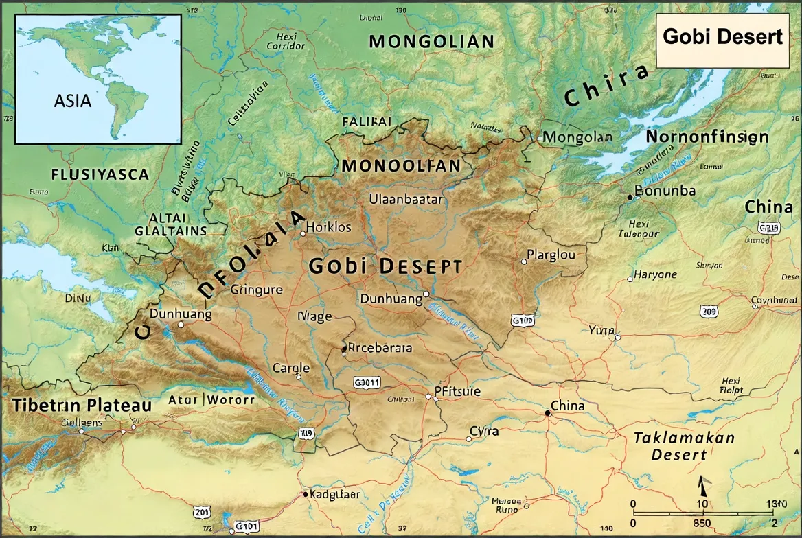
At a glance: area, countries, climate, and terrain
Area & jurisdiction: the Gobi covers roughly 1.3 million km², crossing national borders and ecological gradients. Core countries covered in the pack: Mongolia and China. Treat the coverage as a spatial corpus with fuzzy margins — the map pack explicitly annotates boundary uncertainty and the metadata lists the spatial extent of every layer.
Climate: the Gobi is a cold desert: extreme diurnal swings, frigid winters, hot summers, and low annual precipitation. From a planning perspective, this means you must parameterize logistic models for thermals (human, vehicle) and water consumption with conservative margins.
Terrain characteristics: not an endless sand sea. Most of the domain is gravel plains (reg), gravel plateaus, interdune corridors, and isolated erg fields. Dune fields (e.g., Khongoryn Els) are visually dominant but spatially limited — this matters when you build route plans or estimate surface traction. Elevation-derived hillshade is a critical feature to help predict microrelief and dune slipfaces.
Mapping consequences: treat imagery-based dune polygons as probabilistic features with seasonal variability; annotate uncertainty and capture dates. Offline navigation must combine robust vector GPX with printed A0 maps for situational awareness when GNSS signal or battery life is limited.
What’s included in the Map Pack — deliverables & why they matter
Primary deliverables (packaged as a single ZIP with checksums):
- Printable A0 PDF (300 DPI) — two primary variants: topo and photomap. CMYK, bleed/crop marks, a separate legend layer, and a print-optimized scale bar. Purpose: a foldable wall or glovebox map that’s legible at scale for route planning and emergency navigation.
- Vector GeoJSON & KML — administrative boundaries, protected areas, manually digitized dune polygons, fossil-formation extents, and vetted POI layers (water, fuel, ranger stations). Purpose: easy import to QGIS and Google Earth for analysis or editing.
- GPX route files — three curated routes exported as GPX with route segments, named waypoints, and optional recorded tracks. Each waypoint has structured attributes (name, type, verification_date, notes).
- MBTiles offline tile package — pre-generated raster tiles covering the pack area at multiple zooms, suitable for OsmAnd, Maps.me, and other offline apps. Purpose: mobile basemap with imagery + terrain hillshade.
- Field Handbook (1-page PDF) — critical logistics: water/fuel guidance, permit summaries, templated fossil-report email, safety checklists sized to fold into a glovebox.
- README + MD5 checksums + attribution.txt — metadata, licenses, source dates, and an md5sum example to validate every file after download.
Why this matters: the pack is interoperable across formats and devices. The A0 PDF handles large-scale Situational awareness and printing; GeoJSON/KML enables scholarly analysis and integration with GIS workflows; GPX allows straightforward device navigation. MBTiles make the map usable when satellite coverage or network connectivity fails.
How the Gobi is mapped — data sources, processing pipeline & best practices
Think of this as the data engineering section of the pack.
Layering strategy (feature engineering):
- Base elevation (DEM): SRTM at 30m/90m for contours and derived hillshade; also process DEM-derived microrelief to highlight dune slopes and gravel ridges.
- Imagery: Sentinel-2 mosaics for recent optical context; Landsat composites used historically. Implement cloud filtering and seasonal mosaicking to reduce noise.
- Vectors: OpenStreetMap baseline for settlements and roads; national protected-area shapefiles for formal boundaries; targeted manual digitization for dune polygons and fossil-formation outlines based on published geological maps.
- Points of interest (POIs): vetted water points, fuel stations, ranger stations, and institutional contacts. Each POI entry includes a verification date, a source note, and a confidence score for reliability in the field.
Data provenance & metadata: every layer includes:
- source name and URL or citation,
- capture or compilation date,
- license or usage restrictions,
- limitations (e.g., dune polygons approximate, water points seasonally variable).
Projection & coordinate practice: edit in local UTM zones for accuracy, then export to WGS84 (EPSG:4326) for GPX/KML compatibility. Include EPSG tags in the GeoJSON.
Versioning & reproducibility: include a changelog and a versioned release tag. Use MD5 checksums for integrity. For teams, keep a changelog of any field-verified edits (date, editor, note) and include a “last verified” timestamp for critical water/fuel POIs.
Printable A0 (300 DPI) — print checklist & technical specs
File name example: Gobi_A0_topo_300dpi_CMYK.pdf
Printing checklist (step-by-step):
- Confirm CMYK color profile and 300 DPI resolution. Don’t print RGB exports.
- Request bleed and crop marks if printing at a commercial lab; export with a 3–5 mm bleed.
- Print at 100% scale — do not scale “to fit”.
- Paper: 140–170 gsm outdoor/tear-resistant stock; consider lamination or water-resistant coating for durability.
- Include a clear scale bar (metric & imperial), north arrow, and a legend with large, legible symbols.
- Place a QR code (optional) that links to the pack’s checksum and latest changelog (for teams to verify field updates).
Legend & symbology advice: use large icons that match GPX waypoint labels: fuel (FUEL-XX), water (WTR-XX), campsite (CAMP-XX), fossil-area polygons (FOSSIL-XX). Numbered waypoints should map directly to GPX names for consistency.
GPX / KML / GeoJSON — usage notes and app-specific quick installs
GPX structure: each GPX file contains route segments, named waypoints with structured attributes (type, notes, verification_date), and, where available, a sample track. Include a README example for importing.
App-specific instructions
- OsmAnd: copy GPX to device OsmAnd/tracks or import via menu. Load MBTiles via OsmAnd’s offline maps manager.
- Maps.me: open KML/GPX from the device file manager; save to bookmarks for offline use.
- Gaia GPS / Gaia: upload GPX via Gaia’s website or app import flow; addMBTiles if supported.
- Google Earth (desktop): open KML directly; GPX can be opened but may be converted to paths — test before relying on automatic conversions.
Verification example: after extracting the ZIP, run:
md5sum Gobi_A0_topo_300dpi_CMYK.pdf
and compare to the checksums.md5 file. This ensures file integrity if your download was interrupted.
Offline strategy: load MBTiles to your mapping app and pre-cache tiles for the zoom levels you plan to use. Keep both the offline tile basemap and GPX route on the device so that if one fails, you have redundancy.
Three curated routes — operationally annotated
Each route is supplied as GPX (route + waypoints ± track) and a printable route card. Waypoints classify camps, fuel, water, and photo viewpoints. Every waypoint includes a verification_date attribute.
Short — Khongoryn Els loop (1–2 days)
About: classic dune visitis ideal for first-timers and photography. Short loop focused on dune ridge access, sunrise/sunset viewpoints, and a low-impact overnight camp.
Distance & vehicle: 60–140 km, depending on your start. A high-clearance 4×2 can manage most short legs, but local guidance/4×4 recommended for deep-sand approaches.
Key waypoints included: Sunset Ridge Viewpoint, a recommended low-impact campsite, the nearest fuel stop, and a marshy oasis spot. Each waypoint includes notes about surface conditions and a confidence score.
Operational notes: Avoid steep sand ridges at peak midday when sand temperatures and sun exposure increase the risk. Plan water per person and include a small first-aid kit.
Medium — Bayanzag (Flaming Cliffs / Bayanzag fossil route) (3–5 days)
About: historic paleontological localities, dramatic red cliffs, and museum visits. Route designed for fossil observation (photography only), stratigraphic viewpoints, and engagement with local institutions.
Distance & vehicle: 200–450 km loop, depending on start and museum detours. 4×4 recommended for optional side-tracks.
Permit & ethics notes: fossil removal is illegal without permits. The pack includes a templated reporting email and recommended contacts for the nearest accredited museums.
POIs and metadata: each fossil-area polygon includes formation attribution (e.g., Nemegt), a short stratigraphy note, and legal status. Coordinates are provided in WGS84 with declared accuracy.
Long — South Gobi circuit (7–12 days)
About: an extended overland loop for remote camping, varied terrain, and a deep desert experience. Designed for teams that can self-recover and carry extended supplies.
Distance & vehicle: 700–1,400 km depending on chosen stops.
Inclusions in GPX: fuel waypoints with verification dates, vetted water points, ranger stations, hospital contacts, and alternate route segments for seasonal passability.
Safety & logistics: carry spare fuel, recovery gear, two spare tyres recommended, and satellite communications (PLB or satellite messenger). Mark an emergency extraction waypoint with coordinates and the nearest medical facility.

Field logistics: water, fuel, permits, and timing
Water (human): baseline 1–2 L per person per day under moderate activity; increase to 3–5 L per person per day for hikes or hot conditions. For vehicles, carry sufficient spare jerrycans and include filtration/purification tablets.
Fuel (vehicle): remote sections require significant reserves. Typical practice: carry 40–100 L extra depending on vehicle consumption and remoteness. The GPX includes fuel POIs; each is tagged with the last verification date.
Permits & legal constraints: Fossil collecting is strictly controlled. Do not remove specimens. The handbook contains a short legal summary and points to local museum contacts for reporting.
Timing & seasonal considerations: optimal windows are spring (April–June) and autumn (September–October). Avoid deep winter unless thoroughly prepared. Rain is uncommon but can rapidly make tracks impassable — always check recent reports and use conservative timing for river crossings and ephemeral streambeds.
Fossil-ethics, permits, and reporting
The Gobi has produced globally significant fossils — dinosaur eggs, skeletons, and Mesozoic fauna, especially from formations like the Nemegt Formation. Follow a short, reproducible workflow when you encounter potential fossils:
Do not remove the specimen. Context is scientific value: the matrix, position, and stratigraphic layer matter.
Photograph comprehensively. Include a scale object (ruler or coin) and shoot multiple angles.
Record coordinates. Use WGS84 and note the datum and GPS accuracy.
Describe stratigraphy. Briefly note lithology: sandstone, mudstone, siltstone.
Report promptly. Use the templated email (provided) to contact the nearest accredited museum or authority. Attach photos, coordinates, date/time, and a short stratigraphic note.
Why this matters: removing specimens can destroy scientific context and may be illegal. The pack’s templates and contacts are designed to facilitate rapid, cooperative reporting and to protect you from unintended legal consequences.
Flora, fauna, human culture & survival tips
Flora: drought-adapted shrubs like saxual (Haloxylon) and ephemeral annuals after rain.
Fauna: wild Bactrian camels, Asiatic wild ass (khulan), fox species, occasional snow leopard in rocky margins, and migratory and resident birds at seasonal oases.
People & culture: nomadic pastoralism is common; customs vary locally. Always ask permission before photographing private property or people, and consider hiring local guides — they provide both safety and culturally sensitive access.
Survival basics:
- Navigation: GPS + printed A0 map backup.
- Vehicle kit: two spare tyres if possible, snatch strap, shackles, compressor/pump, spare belts & essential fluids.
- Communication: satellite messenger or PLB recommended for remote travel.
- Health: carry a comprehensive first-aid kit and know basic dehydration/heat-stress treatment. Carry warm layers for nocturnal cold.
Quick planning checklist
| Category | Essentials |
| Navigation | GPX routes, MBTiles offline, A0 printed map, compass, GPS device |
| Water & food | 10–30 L spare water per vehicle, high-calorie rations, purification tablets |
| Vehicle | Spare tyres (1–2), pump, snatch strap, basic tool kit, spare fuel jerricans |
| Safety & comms | First aid kit, PLB/satellite messenger, fire extinguisher, warm layers |
| Documents | Permits, vehicle papers, insurance, and local contact numbers |
Pros & Cons
Pros
- Vast, photogenic, and sparsely visited landscapes.
- World-class paleontological sites.
- Excellent for solitude and overland photography.
Cons
- Harsh temperature extremes and long distances between services.
- Legal restrictions on fossil collecting.
- Slow rescue or repair options in remote sections.
CTA — Get the Map Pack
- Free Preview: A0 PDF (preview page) + sample GPX (short route). Use this to evaluate print quality and waypoint naming conventions.
- Premium Pack: Full A0 print-ready PDFs, GeoJSON/KML, GPX pack, MBTiles, and the field handbook with templates and contact lists. Premium downloads include MD5 checksums and a short support window for POI verification.
FAQs
No. Large parts are gravel plains and rocky plateaus; dunes are present but limited to pockets and dune fields.
Spring (April–June) and autumn (September–October) are the best windows for comfort and road reliability.
Generally no. Most fossil localities are protected — photograph, record coordinates, and report finds to local museums or authorities.
For most curated routes (especially the South Gobi circuit), a high-clearance 4×4 is strongly recommended. Short dune visits can be possible with local transport or guided tours.
Conclusion
Treat the map pack as a tested data product: use the A0 prints, vector assets, and GPX routes together with conservative planning and local permissions to Minimize risk and maximize scientific and personal safety on Gobi expeditions.


