Introduction
The Gobi Desert map pack bundles field-ready, provenance-aware cartography: high-res A0 printable maps, GeoJSON/KML vector layers, and GPX route packs with satellite + elevation overlays. Designed for travelers, researchers, developers, and conservationists working across Mongolia and China, it pairs practical navigation assets with clear metadata, ethical guidance for fossil sites, and offline workflows.
Quick facts — at a glance
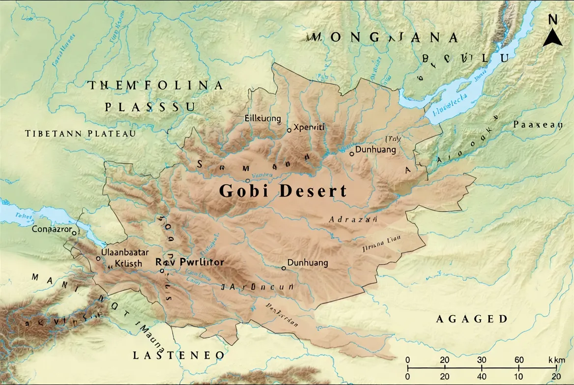
- Estimated area: ≈ 1.3 million km² (arc spanning southern Mongolia and northern China).
- Countries: Mainly Mongolia and China (including the Inner Mongolia region).
- Climate: cold desert — large diurnal & seasonal thermal variance (winters can approach −40°C, summers can exceed +40°C).
- Primary terrain: gravel plains (reg), rocky outcrops, localized erg/dune systems, mountains, ephemeral wetlands.
- Notable attractions: Khongoryn Els; Yol Valley (Yoliin Am); Flaming Cliffs (Bayanzag).
Why this map pack matters
A map pack is not merely pixels or lines — it is the data schema that powers decisions. Consider each map artifact as a labeled example in an NLP training set:
- Overland drivers: require sequential navigation data (GPX sequences annotated with fuel stops, campsite POIs, and passability labels) — analogous to a sequence classification and tagging task.
- Field researchers: need vectorized feature collections (GeoJSON) that carry attribute schemas for protected area status, fossil sensitivity, and confidence scores — analogous to NER + attribute extraction.
- Web developers & content creators: require embeddable vector tiles, optimized MBTiles, and readable legends — analogous to producing pre-processed embeddings for fast inference.
- Conservationists & cultural institutions: require authoritative polygons, reporting contacts, and audit trails — analogous to labeled training corpora with provenance metadata, legal disclaimers, and DOIs.
A single, well-designed A0 topographic PDF (contours, hillshade, and a satellite inset) functions like a human-readable model card on the Basecamp desk: it summarizes the data, lists assumptions, and indicates provenance and limitations. Use the digital GeoJSON/KML for live navigation and the printed map as an immutable backup.
How the maps were built — provenance, sources & transparency
Mapping must be reproducible and auditable. Treat your map pack like a scientific dataset: include a data-source table, version tags, and a “last verified” timestamp in every artifact.
Primary sources and compilation layers used in the pack (canonical data pipeline):
- Base cartography: Natural Earth for country/coastline/major features; OpenStreetMap for tracks, minor roads, and service POIs (fuel, shops, clinics).
- DEM/elevation: SRTM and ALOS as primary DEM sources (conceptually, these are continuous feature fields used to derive hillshade and contours). For provenance labeling, recordthe dataset name, version, spatial resolution, and acquisition date. Use SRTM where lat/lon coverage is reliable and ALOS to fill gaps or smooth artifacts. (We will refer to these as SRTM and ALOS once each.)
- Protected areas: World Database on Protected Areas (WDPA) for global protected-area polygons and local management maps for granularity. (Reference: WDPA.)
- On-ground validation: GPX tracks and trip logs were cross-checked against public route reports; where possible, we added a confidence score per GPX segment.
Good practice: embed a small metadata JSON with each download containing: sources[], date_compiled, last_verified, license, contact. This is your dataset manifest — the model card for field use.
Location and geography — reading the Gobi as a spatial language model
The Gobi Desert is not a homogeneous token stream. It is a composition of subregions and micro-typologies that matter for routing and safety. From a Mapping perspective, we need to expose those subtypes so queries like “find drivable corridor from A to B” return high-confidence results.
Key feature classes to include in vector schema:
- Mountain ranges (e.g., Gurvan Saikhan, Altai fringes) — polygon or line features with elevation attributes.
- Dune fields (ergs) — polygon features with a dune-type attribute (crescentic, linear, star) and dune-crest line geometry for high-resolution navigation.
- Gravel plains (reg) — wide-area surface-type polygons with a passability score and traction risk polygons (soft-sand pockets).
- Badlands & cliffs — line/polygon features flagged as fossil-rich where sampling is regulated.
- Playas & salt pans — seasonal polygons with hydrological seasonality metadata (months active).
- Valleys & gorges — narrow polygon/line features with contour density and stream attributes.
Map tip: include a terrain_type attribute (dune, gravel, rock, playa) for each major polygon. This helps automated routing engines assign traversal costs (a cost function analogous to a loss function in optimization).
Climate & weather layers to include — dynamic features and temporal labels
Because the Gobi Desert exhibits strong seasonal and diurnal variance, include temporal overlays to inform pathfinding and planning:
- Monthly mean extremes — store as 12 rasters or an attribute table: month -> min/max mean temperature extremes. Color-code months with exponentiated risk.
- Precipitation isolines — iso-precipitation contours (<50 mm, 50–100 mm, 100–200 mm, etc.) useful for hydrological inference and soft-sand likelihood.
- Wind roses — vector descriptor per gridcell for dominant wind direction and mean wind speed. Useful for dune migration prediction and camping site selection.
- Seasonal accessibility tag — per-track or segment label: passable_dry_months (list), spring_thaw_risk (boolean), snow_closure_months (list). This is essentially a temporal annotation schema for each vector feature.
Add metadata: “verified on [YYYY-MM-DD]” for each temporal layer. This reduces label drift and communicates where retraining (recompilation) is necessary.
Landscape features — what to draw and why
A good map surfaces the right features at the right scale and with the right symbology. Treat map design as feature engineering.
- Dunes (ergs): include dune-crest polylines and approach tracks. Crest lines act like sequence boundaries in a text: crossing a crest is an event with energetic cost (for vehicles/hikers).
- Gravel plains are represented as large polygons with soft-spot risk polygons inside them. Each risk polygon should carry a confidence attribute derived from trip reports and satellite-inferred surface roughness.
- Rock outcrops/badlands: mark fossil zones with a “protection_level” attribute and an associated museum_contact field. These are sensitive NER tags — consider redaction in public datasets if legal constraints require.
- Salt pans/playas: mark as temporal landmarks with “flooded_if_mm> X” attributes.
- Valleys & gorges: use dense contours and include micro-trail markers.
Flora & fauna layers — ecological NER and confidence scoring
Vegetation and wildlife are sparse but essential semantic signals:
- Vegetation zones: saxaul/tamarisk patches, steppe grasses, willow/riparian corridors. Provide a percent_coverage attribute and seasonal_foliage flag.
- Forage/fuel areas: mark community-managed grazing polygons to help reduce human-wildlife-livestock conflict.
- Wildlife hotspots: store point features with species, observation_date, and observation_confidence. For conservation products, consider adding a temporal decay to observation weight (older sightings reduce confidence).
For conservation outputs, provide a confidence_score (0–1) for each wildlife feature and document your observation sources. For sensitive species or breeding grounds, use spatial fuzzing or generalized polygons to avoid exposing precise nest/breeding coordinates.
Human history & cultural layers — sensitive labels & respectful design
The Gobi Desert has a rich human record. Your mapping taxonomy should carry cultural sensitivity flags:
- Historical caravan routes — interpretive overlay with a provenance attribute (source: historical record or local knowledge).
- Settlements & service nodes — point features with service_quality attributes and distance-to-next-fuel metrics. These are critical for logistic planning.
- Sacred or culturally sensitive sites — mark as restricted access with an advisement attribute: “request permission / local contact required”.
- Museums and reporting contacts for fossils — include contact_info fields and a reporting_procedure description.
When publishing fossil site maps, always include an ethics statement in plain language: do not remove artifacts; report discoveries to the listed museum contacts.
Spotlight: major sites, waypoints & what to map
Khongoryn Els — Khongoryn “Singing Dunes”
- Map items: basecamp polygons, campsite flats, 4×4 approach tracks, nearest fuel node, elevation profiles across crest.
- Why: Dune fields are highly localized; a precise approach track avoids vehicle strandings and protects herder land.
Yol Valley (Yoliin Am) — Yol Valley
- Map items: trailheads & parking, stream crossings, emergency egress routes.
- Why: Narrow gorges can retain ice year-round; contour detail and micro-elevation data matter.
Flaming Cliffs (Bayanzag) — Flaming Cliffs / Bayanzag
- Map items: protective polygons, visitor access corridors, and museum contacts.
- Why: paleontological sensitivity — removal and export of fossils is often illegal and ethically wrong.
Dalanzadgad — Dalanzadgad
- Map items: fuel & service points, accommodations, emergency contacts.
- Why: main operational base for south Gobi.
Ulaanbaatar — Ulaanbaatar
- Map items: long-distance transport links, vehicle rental hubs, spare-parts suppliers, and initial route planning infrastructure.
(Each of these named entities is a node in the route graph; compute shortest-paths subject to constraints: fuel range, seasonal closures, and passability.)
Survival tips — map-centric advice
Maps minimize risk, but they do not eliminate it. Treat maps as part of a redundant navigation stack:
- Carry redundant navigation: printed A0 (or A2) map + two independent digital devices with MBTiles.
- Use standardized waypoint names: fuel_1, camp_A03, water_cache_1 — this reduces confusion when merging GPX sequences from multiple contributors.
- Mark soft-sand hazard polygons where vehicles frequently bog down; assign a soft_sand_risk_score and an advice string (e.g., “use deflated tires; max axle pressure X PSI”).
- Plan emergency egress: always mark at least two exit corridors and the nearest towns with medical capabilities. Include estimated transit time assuming a conservative average speed and a margin for recovery.
Operational metadata pattern: each GPX segment should include attributes: composer, date_recorded, confidence, and verification_notes.

Tourism: attractions & travel planning
Common activities and recommended map assets:
- Sand hiking & duneboarding at Khongoryn Els — supply an A0 inset, GPX access tracks, and an elevation profile for the dune crest.
- Canyon walks at Yol Valley (Yoliin Am) — provide trail maps, parking, and emergency egress routes.
- Fossil visits at Flaming Cliffs (Bayanzag) — include protected polygons and visitor guidance.
- Best seasons: late spring through early autumn for most road access. Mark seasonal closures (spring thaw) and local weather advisories.
Vehicle advice: high-clearance 4×4 recommended. Annotate tracks with vehicle_suitability tags.
Fuel planning: annotate distances between confirmed fuel points (many stretches exceed 200 km). For route validation, include an estimated fuel_consumption field based on vehicle assumptions.
Permits: map permit offices and protected-area ranger stations; add an attribute permit_required=true/false and a contact_info field.
Interesting map facts
- The Gobi Desert is more of a cold desert than a classic hot sand sea — dunes can freeze.
- The Flaming Cliffs (Bayanzag) were the site where dinosaur eggs and many important specimens were first documented.
- Some dunes “sing” due to grain friction and resonance — a physical phenomenon that is delightful, verifiable, and worth annotating as a cultural curiosity layer for tourists.
Environmental issues & responsible mapping
Maps can cause both benefits and harm. Use spatial ethics:
- Fossil poaching & illicit trade — mark no-go zones, museum reporting contacts, and publish an ethics statement. If publishing raw fossil locations, get legal counsel.
- Desertification and land change — include a land-change overlay (NDVI / soil erosion index) to indicate where anthropogenic pressure is growing.
- Tourism impact — suggest visitor routes that avoid fragile dune crests and wildlife breeding areas.
- Community lands — mark community-managed zones and indicate where to obtain local consent.
When making datasets public, consider two tiers: a public dataset with blurred/aggregated sensitive features and a restricted dataset for vetted institutions with a data-sharing agreement.
Practical mapping how-to
Treat your GIS workflow like a data science pipeline: ingest → clean → transform → annotate → validate → publish.
Recommended file & CRS conventions
- Web tiles: EPSG:3857 (Web Mercator) for Mapbox/Leaflet tiling. Use the standard XYZ tile schema.
- GPS / raw data: distribute GPX and GeoJSON in EPSG:4326 (WGS84). This is the ground-truth coordinate system for consumer devices.
- A0 PDFs: export at 300 DPI with embedded legend and georeference tags (a georeferenced PDF or associated worldfile).
- Contours: 20–50 m intervals depending on local relief; choose denser contours in valleys/gorges and sparser in flat reg plains.
Tooling & attributions
- Use OpenStreetMap for tracks and service POIs — remember to include OSM attribution.
- When serving tiles via a third-party service, include required attributions for imagery and DEM sources (SRTM/ALOS/others).
Minimal Leaflet snippet
// Add hillshade tile + GeoJSON boundary
L.tileLayer(‘https://{s}.tile.provider/{z}/{x}/{y}.png’).addTo(map);
L.geoJSON(gobiBoundaryGeoJSON, {onEachFeature: onFeature}).addTo(map);
// Remember OSM & DEM attribution in footer
(If you use a hosted provider, include the proper attribution strings in your map footer.)
Offline workflows — MBTiles, import manifests & device readiness
For field-ready maps, prepackage MBTiles for satellite and hillshade. Provide import manifests for common mobile tools (e.g., Gaia and QField). The manifest should contain:
- filename, filetype, extent (minlon, minlat, maxlon, maxlat), CRS, and suggested import instructions.
- a short README explaining how to import MBTiles in the app (steps for Gaia/QField).
- checksums (SHA256) for integrity.
Table — Comparison of major Gobi sites
| Site | Type | Best Season | Map assets to include | Notes |
| Khongoryn Els | Dune field | June–Sept | A0 inset, GPX access tracks, elevation profile | Great for camping; localized, be mindful of herders |
| Yol Valley (Yoliin Am) | Canyon/gorge | June–Sept | Trail map, parking, emergency egress routes | Ice pockets may persist into late summer |
| Flaming Cliffs (Bayanzag) | Paleontological badlands | May–Sept | Protected polygons, visitor access map | Fossil removal restricted |
| Dalanzadgad | Town (service hub) | Year-round | Fuel & services layer | Main south Gobi base |
| Ulaanbaatar | City/hub | Year-round | Transport links, rental, spare parts | Route start for many expeditions |
Pros & Cons
Pros
- Unique landscapes and world-class paleontology.
- Concentrated hotspots make targeted mapping highly effective.
- Low light pollution facilitates night-sky mapping and astro-navigation overlays.
Cons
- Very long distances between services — precise mapping of fuel and service nodes is mission-critical.
- Weather extremes and seasonal closures make stale maps dangerous.
- Legal & ethical restrictions around fossil sites require authoritative mapping and outreach.
Detailed step-by-step: build a sample A0 map
Treat each step as a pipeline stage with input and expected output.
Step 1 — Gather base data (ingest)
Download: Natural Earth for country and major features; OpenStreetMap for tracks; DEMs from SRTM / ALOS. Build a folder structure: base/, dem/, osm/, protected/, gpx/.
Step 2 — Clean & clip (preprocessing)
Clip DEM to map extent, reproject to working CRS. Remove slivers and tiny OSM features that clutter the final map. Run topology checks on polygons.
Step 3 — Generate hillshade & contours (feature extraction)
Use DEM to compute hillshade, slope, and contours (20–50 m). Export contours as GeoJSON/SHP. Consider deriving a multi-directional hillshade for printing clarity.
Step 4 — Style map (visual encoding)
Choose a restrained palette. Dunes: warm sand tones; gravel plains: light grey; water: blue; hillshade: soft shadows. Include a satellite inset in one corner to connect abstracted cartography with the photographic baseline.
Step 5 — Add POIs & tracks (annotation)
Add GPX routes with waypoints labeled as fuel, camp, clinic, and water_cache. Verify distances between fuel points and add a fuel_distance_km attribute.
Step 6 — Build legends & metadata (model card)
Add legend, scale bar, north arrow, and a data-source block listing sources and the last verification date. Append a small JSON metadata block that will be downloadable alongside the map.
Step 7 — Export (packaging)
Export A0 at 300 DPI. Save editable source files (QGIS/Arc project, style files) for future updates.
Example: create a simple GPX route
Route name: Ulaanbaatar → Dalanzadgad → Khongoryn Els
Waypoints: UB_start, fuel_1 (GOBI_FUEL_1), camp_KH01, khongor_view, dalanzadgad_fillup.
Notes: mark fuel distances — Ulaanbaatar to Dalanzadgad ~ 460 km (verify before travel); always add 20% fuel margin.
GPX segments should include attributes: recorded_by, recorded_date, confidence, and notes for seasonal passability. Use standard GPX extensions or attach an adjacent gpx_manifest.json for richer metadata.
FAQs
A: The Gobi is roughly 1.3 million km² in area and stretches across southern Mongolia and northern China. (This is the canonical estimate used in our dataset metadata; include this number in the A0 map’s data block.)
A: Yes — Khongoryn Els is routinely visited by 4×4 vehicles. Use mapped GPX approach tracks and plan fuel carefully. Always verify local conditions and seek recent trip reports before committing to a route.
A: No. Many fossil sites (including the Flaming Cliffs (Bayanzag)) are protected. Removing fossils without proper permits is illegal. Maps should show restricted zones and museum contacts, and you should include an ethics statement advising users to report rather than remove specimens.
A: Late spring to early autumn for most road access. Always check local conditions and seasonal closures, especially spring thaw windows, which can render tracks impassable.
Conclusion
Use the A0 PDF as your basecamp planning sheet, GeoJSON/KML for web/GIS integration, and GPX for on-device Navigation and verification. Tell me which artifact you want first — a legend-ready A0, a GeoJSON boundary, or a GPX route — and I’ll produce it.


