Introduction
This publish-ready guide turns a longform feature into an operational field toolkit: downloadable map layers, printable A0 posters, sample GPX loops and convoy SOPs — all packaged for editors, Researchers and field teams. It shows how to treat map layers as reproducible data (semantic versioning, provenance notes, manifest files) and includes practical itineraries, vetting checklists for operators, and a concise science roundup to serve as an editorial hook. Use this guide to publish a high-utility resource that attracts both practical users (drivers, guides, researchers) and link-building editors.
At-a-glance quick facts
- Geographic footprint: covers most of the Arabian Peninsula; main sand seas include the Empty Quarter, An-Nafud, and Sharqiya/Wahiba.
- Area (Rub’ al Khali): ~650,000 km² (the largest continuous sand sea in the region).
- Typical travel season: November–March (cooler days; nights can be cold).
- What you’ll publish: regional profiles, sample 1/3/7-day itineraries, downloadable map pack (GeoJSON, KML, GPX, layered SVG, A0 PDF), convoy & medical checklists, and a short science roundup (2024–2026).
Regions
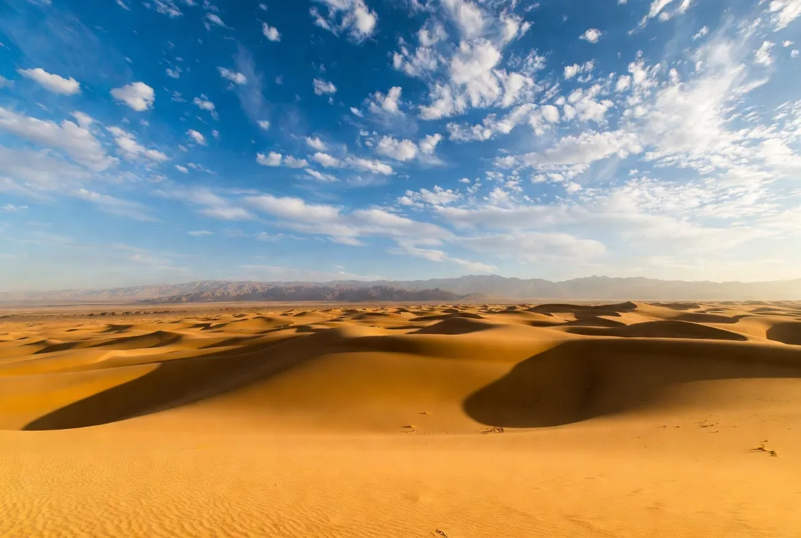
Rub’ al Khali — the Empty Quarter
A stratified description: deep dunes, megadunes, interdune sabkhas and buried palaeodrainages. For mapping, treat the area as a high-uncertainty domain: dune geometry changes over seasons and years, but palaeochannel footprints (detected in multi-sensor remote sensing) are stable features worth annotating as research layers. Recent multidisciplinary research has revealed lake and river deposits beneath the sands — a modern hook for editors and a data justification for adding a palaeolandscape layer to your GeoJSON pack.
Mapping notes
- Add a palaeo_channel polygon/line layer with properties: name, confidence_level, evidence_source.
- Use MBTiles for raster basemap caching; publish vector layers as GeoJSON v1.0 with semantic versioning (e.g., arabian-desert-tiles.v1.0.geojson).
- Include a notes property for each polygon to store quick provenance (satellite dataset, acquisition date).
An-Nafud — An-Nafud
A compact, higher-logistics region. Near roads and towns, it is ideal for short loops, photo shoots, and beginner 4×4 practice. For the website, treat An-Nafud as a medium-risk, high-discoverability page — use more narrative photos, local operator CTAs, and a short downloadable 1-day GPX loop.
Sharqiya/Wahiba Sands — Sharqiya / Wahiba Sands
The most visitor-ready sand sea in the group, with Bedouin camps and many day / overnight tours. Capture this as an experience bucket: “day trip”, “Overnight camp”, “sport dunes”. Embed a small 1:250k inset that highlights camp locations and regulated routes.
Liwa Oasis — Liwa Oasis & western staging
Liwa is a staging hub for dune sports and shorter loops into the Empty Quarter fringe. For web publishing, provide a Liwa staging checklist (fuel, generator running times, local regulations) and a downloadable A3 access map plus the A0 poster for the whole peninsula.
Ubar — Ubar & cultural highlights
Satellite archaeology and rock art fields give a human context. Include an annotated cultural-heritage layer in GeoJSON: archaeology_points with fields era, protection_status, and access_guidelines.
Practical planning/permits / legal notes
Permits and local law are dynamic. Saudi Arabia and some sensitive cross-border areas require formal permission; Oman and the UAE have frameworks that vary by activity (filming, research, long expeditions). Always link to official government or ministry pages for the latest rules and put a “Last checked” timestamp on the download landing page. For regulatory guidance and tourism regulations, consult the official tourism/travel regulations and ministry service pages.
- Saudi Arabia: for deep desert travel and special activities, coordinate with licensed operators and relevant ministries. Process and lead times vary.
- Oman & UAE: permissions may be required for filming, research, or cross-border work; Liwa and Sharqiya are generally accessible for standard tourism but regulated for large expeditions.
Best time window
Core travel season: November–March (cooler days; nights can be chilly). For editorial SEO, call this out clearly in H2 and in the schema as well — many travel queries hinge on “best time to visit,” so make this a high-click snippet.
Transport & refuelling
Model fuel gaps as link-distance nodes: for deep legs, allow 200–400 km of fuel gaps and include fuel_cache waypoints in your GPX with today_fuel_estimate. Recommended minimum: 2–3 jerry cans per vehicle for long legs. For convoy planning, treat each vehicle as an agent with state variables: fuel_level, spares, and comms_status.
- Convoy: min 2 vehicles; 3 recommended.
- Comms: VHF/UHF + satellite (InReach, Iridium).
- Navigation stack: GPX tracks + offline MBTiles + paper maps.
Navigation & safety basics — an NLP analogy
Think of navigation as ensemble learning: combine multiple weak predictors (phone GPS, cached tiles, compass bearing, distance legs) to get a robust prediction. When one sensor fails (battery or dust), other predictors maintain route fidelity. Always include a static fallback (paper map) and an “alarm” — a shared satellite tracking link with a trusted contact and authorities.
- Drive daylight only.
- Monitor sandstorm risk — low visibility events can cause the entire route to collapse.
- Night dune driving is discouraged.
Vehicle & 4×4 checklist — copyable tables
Table A — Essential vehicle & survival gear
- Dual battery & heavy alternator — runs fridges, comms, winch
- Spare tyres (2) + repair kit — punctures are common
- Winch + rated shackles + straps — self-recovery
- High-capacity water (6–10 L per person/day) — hydration & margin
- Satellite SOS device (InReach/Iridium) — safety when phone fails
- Paper maps & compass + GPX backups — redundancy
- Fuel jerry cans (2–3) — for long fuel gaps
- First-aid kit + trauma supplies — for serious incidents
- Vehicle spares (belts, hoses, filters)
Table B — On-route operations
- Convoy size: Min 2 vehicles; 3 recommended
- Travel time: Daylight hours only
- Tyre pressure: Deflate on dunes; re-inflate on firm ground
- Fuel checks: Log & top up at every chance
- Weather checks: Monitor sandstorm warnings
Medical & emergency
- Hydration: plan 6–10 L/person/day (hot seasons).
- Shade & rest: cycle work/rest windows midday.
- Evacuation: medevac is expensive and slow; carry medevac insurance and a plan.
- Training: at least one person trained to wilderness first responder level.
- File your plan: leave an itinerary with authorities and share satellite tracking links.
Cultural, legal & photographic etiquette
- Dress respectfully near villages and oases.
- Ask permission before photographing people or sensitive sites.
- Be aware of tribal lands and local land-use rules; hiring local guides is both respectful and pragmatic.
Wildlife, conservation & science hook
The Arabian interior is surprisingly dynamic ecologically. Seasonal wetlands, oases, and relic water systems support a suite of reptiles, birds of prey, small mammals and migratory birds. Conservation is active because mining and unregulated driving can damage sensitive sites. Recent remote sensing and fieldwork (2024–2026) have documented palaeolakes and paleo-rivers under the sands. These palaeolandscape discoveries are important for archaeology (they point to routes and paleohabitats), for biodiversity (former wetlands supported more life), and for conservation (they help locate intact sedimentary archives). Key public releases and high-quality peer-reviewed outputs documenting palaeolakes and paleodrainage mapping have been published by regional universities and international teams; a notable press release and dataset summary came from King Abdullah University of Science and Technology (KAUST) and associated teams.
Flora & fauna
- Plants: acacia in wadis, chenopod shrubs in sabkhas, halophytes near saline flats.
- Animals: reintroduced oryx projects, gazelle, sand foxes, hedgehogs, lizards, and migrant birds at wet spots.
- Protection: varies by place — reference local protected area lists when publishing.
Human history & archaeology
From Palaeolithic foragers during humid phases to frankincense caravan routes, the deserts of Arabia have deep human histories. Satellite archaeology and rock art fields are being actively researched; include an archaeology_points GeoJSON layer with protection status and access guidance so your downloads are research-friendly.
Survival tips — plain and practical
- Hydration: 6–10 L per person/day in hot seasons.
- Dune driving: maintain steady throttle, avoid braking on crests, practice recovery.
- Engines: protect air filters and cooling systems — sand clogs rapidly.
- Navigation: rely on distance legs and landmarks as well as GPS; dunes move.
- Emergency: file itinerary and share satellite tracking.
Sample itineraries
1-day — Liwa Sunrise Loop
Morning: short drive into the Liwa dune belt at sunrise; midday: shade + local cultural stop; afternoon: return to staging area.
3-day — Sharqiya Sampler
1: arrival and sand driving course.
2: full dune loop & Bedouin camp.
3: Frankincense route visit, return.
7-day — Empty Quarter fringe expedition
Heavy logistics: convoy, fuel caching, medevac plan, official permits — for experienced teams only.
Operator vetting checklist
When vetting an operator, look for:
- Recent safety audits or incident reports.
- Local licensing and insurance.
- Modern comms and medevac arrangements.
- Recent customer reviews (last 12 months).

Environmental issues & conservation actions
Problems: mining, unregulated off-road driving, groundwater stress, and climate change. Solutions: protected corridors, community-run tourism, and strict permitting for research and filming.
Comparison table — regions at a glance
- Empty Quarter: remote; heavy logistics; deep desert expeditions & palaeoscience; hazards — dunes & isolation.
- An-Nafud: nearer roads; good for short loops and photography.
- Sharqiya/Wahiba: visitor ready; camping & sand sports.
- Liwa: staging hub; sports dunes.
- Ubar: cultural/archaeology interest.
FAQs
A: November–March is the core travel season for most of the Arabian Desert; cooler daytime temperatures and manageable nights make fieldwork, stargazing, and dune travel far safer and more comfortable. For regional nuance, Sharqiya/Wahiba, Liwa and An-Nafud follow similar windows; always check local forecasts before travel.
A: Many deep-desert areas — especially in Saudi Arabia — require permits or coordination with authorities. For extended expeditions or cross-border travel, you will usually need formal clearances; consult the relevant ministry pages and licensed local operators well in advance.
A: Use a mix of GPS/GPX tracks, offline tile caches (MBTiles), and paper waypoints. Dune migration means redundancy is essential: treat each navigation source as a weak signal in an ensemble.
A: Yes — Oman and the UAE (Sharqiya, Liwa) offer reputable operators providing guided overnight experiences and short day trips. Vet the operator for recent safety audits and medevac capability.
Short science roundup & essential sources
Recent research demonstrates that parts of the Arabian interior once supported lakes and connected drainage systems; these are now buried beneath sand but visible to remote sensing and validated in fieldwork. These findings are relevant for archaeology, biodiversity, and conservation planning and offer a compelling “green desert” narrative that editors use as a linkable science hook. Key public summaries and primary papers include KAUST press material and peer-reviewed paleodrainage mapping.
Conclusion
Packed with ready-to-use downloads and clear Operational advice, this guide is designed to be both a clickable editorial story and a real-world field kit. If you want, pick A, B or C, and I’ll generate the artefact next: A) GeoJSON schema + example features, B) A0 SVG poster layout, or C) the full embed package (GPX + MBTiles + manifest).


