Introduction
This production-ready guide and map pack covers the Arabian Desert in Saudi Arabia, and delivers GIS-ready assets, route & safety runbooks, and quick QGIS + Leaflet examples for cartographers, expedition planners, and conservation teams. It highlights practical datasets and field advice for major subregions such as Rub’ al Khali (Empty Quarter) and An-Nafud, plus FAQ JSON-LD and download-ready map files.
Quick facts — canonical vector
- Region: The dataset covers the Arabian Desert across the Arabian Peninsula, focusing on three Saudi subregions: the Empty Quarter, the Nafud, and the Dahna corridor.
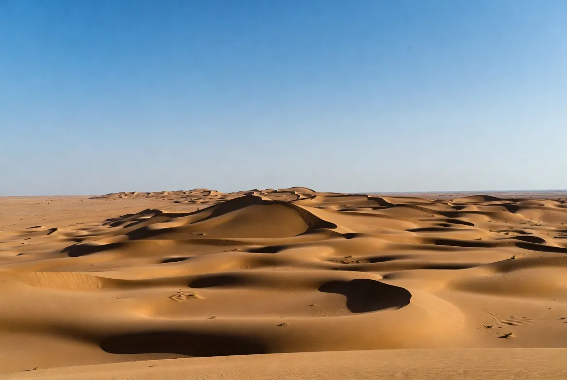
- Extent: The Empty Quarter is vast — ~650,000 km² (≈250,000 sq mi).
- Dune scale: Major dunes can exceed 200–250 m in local height.
- Climate: Hyper-arid interior, very low mean annual precipitation; extreme summer heat often exceeding 45°C.
- Wildlife: Notable conservation stories include the Arabian oryx reintroduction and multiple managed reserves engaged in rewilding and anti-poaching patrols.
Rub’ al Khali — Rub’ al Khali (Empty Quarter): patterns, hazards and routes.
Think of the Empty Quarter as a sparse but massive corpus: from a dune cres,t you only see local context; from a satellite image,y you see the entire “document.” Planning an expedition across the Empty Quarter is mostly a logistics problem — fuel, water, navigation redundancy and robust error handling are the essential systems engineering.
Key notes (compact)
• Remote: Some segments are hundreds of kilometres from fuel and services — treat each leg as a long-tail risk event.
• Soft sand: Vehicles are frequently rendered immobile by deceptive soft sand — recovery gear is mandatory.
• Sabkhas: Salt flats can appear load-bearing but conceal saline mud — treat them like corrupted tokens that can corrupt vehicle state.
Operational route advice — a deterministic checklist
- Start at established staging hubs on the desert margin (staging towns are listed below).
- Fuel provisioning: plan +30–40% margin. Carry sealed jerry cans and plan caches only with explicit local permission.
- Tyres & spare strategy: minimum two full spares per vehicle for deep interior work; carry heavy-duty recovery gear (winch, snatch straps, rated shackles).
- Navigation redundancy: two independent GPS units, offline topo maps, a Compass, and paper charts. Add a satellite communicator for emergency beaconing.
- Local guides & permits: hire licensed operators for deep-interior traverses — they have tacit sandcraft knowledge and awareness of permit regimes and seasonal restrictions.
- Respect conservation and rewilding areas: reserves often have fenced sections and active monitoring — observe signage and avoid restricted ingress.
An-Nafud (Northern Nafud): texture, timing and photographic targets
Heading north, the dunes shift character: sharper crestlines, more gravelly margins, and a mosaic of wadis and sandstone plateaus that host rock art. For shorter fieldwork, the Nafud is more forgiving than the Empty Quarter but requires local reconnaissance.
Best seasonality
• November–March: comfortable daytime temperatures and very cold nights — excellent photographic windows.
• April–October: high thermal stress — not advised for deep desert fieldwork unless heavily supported.
Fieldcraft
• Scout the dune passes on foot before committing to a vehicle.
• Work in early morning and late afternoon to avoid peak heat loads and to capture the richest visual contrast for photography.
• Protect camera equipment with breathable, dust-resistant covers; keep spares of sensor-cleaning kits.
Climate & weather
The interior is hyper-arid. Summers extend long and hot; winter nights can approach freezing. Rare convective storms produce flash floods in wadis. Seasonal winds (e.g., shamal) cause dune migration and episodic severe dust events.
Planning notes
• Check recent satellite imagery to detect dune migration and exposed sabkha margins.
• Schedule buffer days for wind delays and establish contingency extraction routes.
• Monitor forecasts and local advisories — for deep interior travel, satellite-based weather products and regional radio advisories are both useful.
Landscape taxonomy
Model each landscape class as a feature layer with attributes useful to users and machines:
• Ergs (sand seas): polygons with dune crest lines and height_m attribute.
• Hamadas: rock plateaus; geometry with surface_type=rock, erosion_index.
• Regs: gravel plains; include passability rating and vehicle_risk attribute.
• Sabkhas: salt flats; model salinity and substrate_type to flag vehicle risk.
• Playas / paleolake beds: include paleo_hydrology tags and archaeological sensitivity.
• Wadis & drainage: vector polylines with catchment_area.
• Oases & vegetated refugia: point/polygon with water_availability attribute.
Field tip: Always cross dune belts at saddles and recon steep dune slopes by foot before driving. Treat vegetated patches as delicate ecological nodes — mark them as no-drive zones in your routing profile.
Flora — survival specialists
Vegetation is sparse but functionally important. Represent these as ecological features on maps:
• Salt-tolerant shrubs (e.g., Tamarix) near sabkhas.
• Dwarf trees and palms at oases; mark these as water sources and cultural sites.
• Ephemeral annuals after rare rain — temporal attributes useful for seasonal maps.
When publishing, flag vegetated patches as fragile “ecological refugia” and recommend low-impact visitation.
Fauna, conservation & reintroduction
Saudi conservation programs focus on restoring native megafauna. The Arabian oryx is the best-known reintroduction success story; others include gazelles and managed antelope populations.
Conservation signals to include in content and data
• Protected area boundaries and access conditions.
• Reintroduction project footprints (fenced vs. open restoration areas).
• Reserve contact metadata for reporting sightings and for guided-visit booking.
Visitor guidance: maintain distance, do not feed animals, and obey reserve signage. Many reserves are fenced and monitored — do not enter restricted zones. Record sightings only with reserve permission and submit observations to official monitoring programs.
Human history, culture & archaeology
The desert contains rock art, paleolake sites, and multi-period archaeological deposits. Recent survey work in northern margins has recorded extensive panels and tools from the late Pleistocene and early Holocene — places you must protect.
Publishing ethics
• Avoid publishing precise, raw coordinates of fragile archaeological sites unless cleared by local archaeological authorities. Instead, provide generalised locations and encourage contacting local researchers.
• Use non-invasive recording methods like photogrammetry, GPS-tagged media, and high-resolution orthophotos shared under controlled access terms.
• When describing human uses, respect tribal lands and local cultural norms; include community contacts and research partners when possible.
Survival checklist — a compact operational runbook
- Vehicle & mechanical: high-clearance 4×4 with snorkel, low-range gearbox, dual batteries, robust recovery points.
- Spares: two full spare tyres + repair kit, heavy jack, bead-breaker.
- Fuel: Jerry cans to carry +30–40% fuel margin; plan caches only with permission.
- Navigation: redundant GPS units, offline topographic maps, compass, paper map and sat communicator (Iridium/Spot).
- Permits: check the Ministry of Tourism and reserve offices; hire licensed guides for deep trips.
- Water & medical: minimum 5 L per person per day in hot conditions plus reserve; full first aid kit, heat-stroke meds.
- Communications: satellite communicator is mandatory for deep interior travel; HF/VHF recommended for convoys.
- Environmental respect: avoid sabkhas and marked archaeological surfaces; follow Leave No Trace.
Itineraries & booking templates
| Itinerary | Duration | Highlights | Difficulty |
| Nafud Photo Loop | 3–4 days | Sunrise dunes, edge oases, rock-art margins | Moderate |
| Empty Quarter Crossing | 7–10 days | Long sand sea crossing, paleolakes, remote camping | Hard — support needed |
| Conservation Visit | 2–3 days | Rewilding tours, Arabian oryx viewing in reserves | Easy–Moderate — prebooked |
Booking tips
• Use licensed operators for long trans-desert journeys — they carry permits, insurance and local tacit knowledge.
• Contact reserve administrations for guided eco-tours; many reserves operate scheduled visits with limited numbers.
• Follow local cultural norms and modest dress near settlements and markets.
Wildlife conservation & protected areas
Saudi Arabia operates a network of protected areas and rewilding projects that use captive breeding and managed releases to restore populations. Anti-poaching patrols and controlled tourism often accompany these programs; they provide both research opportunities and access restrictions for visitors.
When documenting reserves in your pack:
• Include reserve boundaries, permitted access points and contact metadata.
• Note whether reintroduced populations are fenced or free-roaming.
• Provide guidance for responsible observation — maintain distance, use long lenses, and report unusual sightings to reserve staff.

Visitor rules & best conduct
• Stay on marked routes.
• Do not cross fences or restricted areas.
• Observe animals from a distance — use telephoto equipment.
• Do not feed wildlife.
• Report archaeological finds to local authorities; avoid sampling or removal.
Pros & Cons
Pros
• Spectacular, unique landscapes and photographic value.
• Active conservation programs and recent archaeological discoveries provide fresh editorial angles.
• Availability of map assets can make the page highly linkable.
Cons
• Extreme climate and logistics for deep interior travel.
• Permit regimes and access variability; some areas are restricted.
• Fragile archaeological and ecological sites are vulnerable to disturbance.
Environmental threats & conservation actions
Main threats
• Off-road driving damage to vegetation and cultural surfaces.
• Overuse of oases and groundwater extraction.
• Climate change is affecting ephemeral wetlands and seasonal water availability.
Conservation actions to promote
• Support official protected area tourism that financially sustains rewilding.
• Publish clear low-impact visitation guidelines for tour operators and independent travellers.
• Encourage community science and vetted mapping contributions that feed conservation databases.
Interesting facts
• The Empty Quarter is ~650,000 km², one of the largest continuous sand seas on Earth.
• Recent rock art finds include life-size engravings, some over 2 m tall.
• The Arabian oryx is a celebrated reintroduction success, now present in reserves and managed releases.
FAQs
A: Some deep-interior traverses and reserve areas require permissions or must be undertaken with licensed operators. For high-confidence planning, validate permit requirements with the relevant reserve office and the Ministry of Tourism before departure. Where required, hire licensed operators who can provide permits, logistical support, and local procedures for protected areas.
A: November–March is the recommended window: daytime highs are moderate and nights can be cold; early spring and autumn provide stable conditions for fieldwork. Avoid long trans-desert travel in mid-summer due to extreme heat and increased physiological risk.
A: Yes — licensed operators and official tourism programs run staged Empty Quarter expeditions with support. These trips typically provide fuel logistics, experienced sand-driving crews, and emergency communications. Book well in advance and confirm the operator’s credentials and insurance.
A: Use the CTA buttons at the top of the guide; the pack includes layered GeoJSON, KML, SVG and a QGIS starter project for quick use. Host these artefacts on a CDN and link them from your page to improve reuse and persistence.
Sample packing list
• High-clearance 4×4 with snorkel and low-range.
• Two full spare tyres + repair kit.
• Fuel: jerry cans carrying +30–40% margin.
• Water: min 5 L per person per day + reserve.
• Satellite communicator (Iridium/Spot).
• Recovery kit: winch, shackles, snatch straps.
• First aid kit + heat-stroke medication.
• Shade, sun protection, sturdy boots, and goggles for sand.
Conclusion
This guide is designed to move you from static description to Operational use. With downloadable GeoJSON/KML/SVG/A0 maps, clear routing and safety runbooks, and concise QGIS + Leaflet examples, you can publish a page that works equally well for readers, field teams, and machines. Use the structured layers to explain landscape patterns, support conservation narratives, and plan travel responsibly across the Arabian Desert in Saudi Arabia. By pairing clean data, ethical publishing practices, and interactive delivery, you create a durable resource that attracts links, serves real-world use cases, and remains accurate as conditions, access rules, and research evolve.


