Introduction
Publish a production-ready map pack for the Arabian Desert: clean GeoJSON/KML, layered SVG, and an A0 poster, reproducible QGIS/CLI scripts, GPX samples, and field safety checklists so researchers, designers, and field teams can download, embed, print, or import data immediately.
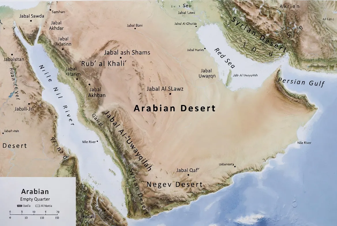
What layers should be in the pack?
Design the pack like a feature schema. Each GeoJSON layer acts like one column in a feature table, with geometry in a geom field and standardized attributes (id, name, type, source, date). Provide both full-resolution vectors and simplified web-friendly derivatives.
Primary layers (GeoJSON group names and intended use):
- admin0 — country boundaries (contextual backdrop). Useful as a low-zoom baselayer and for clipping operations.
- sand_seas — polygons representing large dune seas (Empty Quarter, An-Nafūd, Sharqiya). Primary subject layer for many queries.
- protected_areas — WDPA polygons for reserves, national parks, and strict protection areas.
- elevation_contours — 100m and 500m contours derived from merged SRTM DEM; include elev attribute.
- oases_and_wadis — point dataset for perennial oases, key water points, and named wadis.
- transport — main roads, track classes, and towns for logistics planning.
- gpx_samples — two GPX sample routes (short day loop and a multi-day survey loop) in both .gpx and GeoJSON format.
- metadata.json — the single source of truth for dataset schema and attribution.
Recommended GeoJSON attribute schema
| Field | Type | Description |
| id | string | unique identifier (slug) |
| name | string | human name |
| type | string | category: sand_sea / protected_area / oasis / admin |
| source | string | original data source (Natural Earth, SRTM, WDPA, Sentinel) |
| date | date | snapshot date (YYYY-MM-DD) |
| geom | geometry | geometry in EPSG:4326 |
How audiences use them:
- GIS users load the GeoJSON into QGIS, clip to areas of interest, and run spatial joins.
- Designers drop the layered SVG into Illustrator or Inkscape and tune typography for posters.
- Field teams copy GPX samples to handheld units and use offline OSM tiles.
- Web devs load tiles/MBTiles produced from GeoJSON for embed viewers and enable “Download selection” exports.
Interactive map: features, embed pattern, and UX best practices
The interactive viewer is the single best instrument to convert page views into downloads. Treat it like a model-serving endpoint: a light, robust UI with Predictable query parameters (permaling & layer toggles) and an export API.
Must-have viewer features
- Layer toggles — allow users to switch sand_seas, protected_areas, contours, roads, and oases.
- Measure tool — distance and area in metric and imperial units.
- Place search & permalinks — search bar that updates query string, e.g.,?layer=sand_seas¢er=25.0,20.0&zoom=6.
- Export selection — allow users to draw a bounding box or polygon and export the selection as GeoJSON, KML, or PNG.
- Mobile & print presets — quick buttons to export A3, A2, A1, A0. Allow vector outputs for print (SVG / PDF).
- Embed snippet — one-line iframe pattern for easy copy/paste.
One-line embed pattern:
<iframe src=”https://example.com/embed/arabian-desert-map” style=”width:100%;height:600px;border:0″ loading=”lazy”></iframe>
Permalink examples: append ?layer=sand_seas to pre-enable the sand layer; include &bbox=minlon,minlat,maxlon,maxlat to focus on a study area.
UX tips (practical heuristics):
- Keep the default iframe height 500–600px; on long-form pillar pages, place the embed near the top so users can interact before they scroll away.
- Provide a “Download this selection” CTA inside the map UI for instant exports.
- Implement a server-side export endpoint that accepts a polygon and returns zips with the relevant layers (prettified filenames and metadata).
- Include a persistent “cite this dataset” modal with suggested citation text and a COPY button.
How we made these maps — a reproducible pipeline
Think of the mapping process as a reproducible preprocessing pipeline on raw geospatial corpora. Steps below describe the raw data collection, cleaning, feature extraction (contours, sand masks), and packaging with provenance.
Primary data sources and how to cite them in metadata:
- Base vectors: Natural Earth (admin0, populated places).
- Elevation: SRTM DEM tiles (merged).
- Protected areas: WDPA extracts (snapshot).
- Sand masks: derived from Sentinel multi-date composites vectorized to polygons.
- Local validation: in-country open datasets and peer-reviewed literature.
Short reproducible pipeline (QGIS + CLI):
- Download raw tiles
- Natural Earth vectors (admin0, cultural)
- SRTM tiles covering lon 20°E–60°E, lat 10°N–36°N
- WDPA shapefiles filtered by region
- Sentinel composites (or use Google Earth Engine)
- Merge SRTM tiles (GDAL):
gdal_merge.py -o srtm_merged.tif SRTM/*.hgt
- Create 100m contours (GDAL):
gdal_contour -a elev -i 100 srtm_merged.tif contours_100m.shp
- Derive sand mask from Sentinel composites:
- Band-stack relevant Sentinel bands (e.g., SWIR+NIR+Red)
- Apply thresholding and morphological cleaning.
- Vectorize the cleaned raster to polygons using gdal_polygonize.py or rasterio.features.shape.s
- Tools: SNAP, Google Earth Engine (recommended for reproducibility), or rasterio + numpy for scripts
- Load layers in QGIS:
- Set CRS to EPSG:4326 for exchange files; EPSG:3857 for web tile preview.s
- Use labeling and rule-based symbology.
- Export GeoJSON and layered SVG (maintain attribute schema)
- Simplify for web:
- Use topojson or mapshaper to simplify geometry.
- Always keep the full-resolution vectors inside the zip for print and high-accuracy use.e
- GeoJSON → KML conversion (GDAL/ogr2ogr):
ogr2ogr -f KML arabian_desert.kml arabian_desert.geojson
- Tiling (Tippecanoe for vector tiles):
Tippecanoe -o arabian_desert.mbtiles –drop-densest-as-needed –extend-zooms-if-still-dropping arabian_desert.geojson
- Metadata and license packaging:
- Create metadata.json with dataset_name, version, snapshot_dates, sources (with URLs and retrieval dates), license, and contact.
- Include a CHANGELOG.md for future versions.
Projection advice
- Use EPSG:3857 for web tiles and interactive embed.
- Use EPSG:4326 for GeoJSON and KML exchange files.
- For high-accuracy print projects, local UTM zones or a custom Lambert conformal projection are recommended.
Regional deep dives — mini-pages as subcorpora
Create three supporting mini-pages, each focused on a major sand sea. These act as “subcorpora” that support the main pillar article: they target niche queries and provide internal linking benefits.
Rubʿ al-Khali (Empty Quarter) mini-page
Offer a high-resolution hillshade overlay emphasizing dune heights and paleo-lakebeds. Provide an A1/A0 poster download focused on dune crest lines. Add scientific sample GPX routes for surveys (not tourist crossings) and an explicit safety block: do not cross without experienced guides and a satellite-based emergency plan.
An-Nafūd & Ad-Dahna corridor
Include vector overlays of dune orientation (azimuth) and sand-movement vectors derived from change detection on multi-temporal Sentinel composites. List practical access points — towns, regional airports — for planning scientific logistics. Include a printable mobile map optimized for offline use.
Sharqiya / Wahiba Sands
This mini-page is tourism-friendly: provide short itineraries, seasonal travel advice, licensed tour operator contacts (link to operator lists — but avoid direct endorsements), dune-driving best practices, and biodiversity notes for photographers and naturalists.
Travel & Field Safety
Treat safety advice as operational constraints and requirements in a dataset’s README. Provide a downloadable single-page checklist PDF adjacent to the downloads.
Vehicle & gear
- 4×4 with full service history and two spare tyres.
- Air compressor, recovery straps, sand ladders, hi-lift jack, shovel.
- Carry an extra 25–50% fuel beyond the route estimate.
- Navigation: offline OSM tiles, GPX tracks, paper map backup, and a satellite communicator (SPOT/Iridium).
- Water & food: at least 5–7 L per person/day, adjusted for heat & exertion.
- Shelter & sun protection: high-UV shelter, hats, long sleeves, sunscreen.
- First aid kit and heatstroke response protocol.
Operational rules & permits:
- Check local permit requirements for protected areas and border/transit regulations.
- Respect protected areas and avoid off-route driving in fragile dune habitats; use mapped routes.
- Avoid daytime travel in high summer heat; prefer early morning and late afternoon windows.
Emergency & medical:
- Carry a satellite-capable emergency beacon and an evacuation plan with ground/air extraction contacts.
- Maintain a list of local emergency numbers and consular contact info in both paper and digital forms.
Licensing & attribution
We recommend releasing your derived pack under CC-BY-4.0. This permits reuse while requiring attribution, which maximizes reuse and inbound links. Inside each zip include:
- LICENSE.txt with CC-BY-4.0 text and an explicit statement: “This package (vector styling and derived layers) © 2026 YourSiteName under CC-BY-4.0. Third-party datasets retained under their original licenses.”
- metadata.json listing sources and snapshot dates for data provenance.
Why CC-BY works: many institutions (universities, NGOs, bloggers) will reuse datasets if they have a clear license. A liberal license combined with explicit attribution increases citations and crawl-linkage.

Technical appendix for cartographers & developers
Treat the technical appendix like an Appendix in a dataset paper: include PostGIS examples, tippecanoe, and ogr2ogr commands, and a reproducible command sequence.
SQL example (PostGIS) — clip to a study area
SELECT a.* FROM arabian_sand_seas a
WHERE ST_Intersects(a.geom, ST_MakeEnvelope(minlon, minlat, maxlon, maxlat, 4326));
Processing & tiling
Tippecanoe -o arabian_desert.mbtiles –drop-densest-as-needed –extend-zooms-if-still-dropping arabian_desert.geojson
Common conversions
ogr2ogr -f KML arabian_desert.kml arabian_desert.geojson
gdal_merge.py -o srtm_merged.tif SRTM/*.hgt
gdal_contour -a elev -i 100 srtm_merged.tif contours_100m.shp
Packaging checklist
- GeoJSON: arabian-desert-map-geojson-v1.0.zip
- KML/KMZ: arabian-desert-map-kml-v1.0.zip
- SVG: arabian-desert-map-svg-v1.0.zip
- A0 poster: arabian-desert-map-a0-v1.0.pdf
- Metadata: arabian-desert-metadata-v1.0.json
- License: license.txt
Pros, cons
Pros
- Fills a gap: few sites provide production-ready GeoJSON, KML, SVG, and A0 PDFs in one place.
- Multi-audience: appeals to researchers, teachers, designers, and field teams.
- Link magnet: datasets are frequently cited and reused.
Cons
- Maintenance required: update snapshots when Natural Earth, WDPA, or SRTM updates.
- Legal checks: protected-area access and border specifics are country-dependent and should be validated before recommending travel.
- File sizes: A0 PDFs and MBTiles can be large — serve via CDN and use efficient compression (gzip for GeoJSON, or provide .geojson.gz).
Natural history, people & conservation
The Arabian Desert is ecologically heterogeneous: dune seas, gravel plains (hammada), volcanic fields (harrat), salt flats (sabkha), and palaeolakebeds. Vegetation is sparse but specialized; fauna includes reintroduced species like the Arabian oryx, gazelles, reptiles,s and migratory birds. Threats include overgrazing, illegal hunting,g and off-road damage. Use the protected_areas layer to guide low-impact routing and research planning.
FAQs
A: Definitions vary. The Arabian Desert broadly covers about 1.8–2.3 million km², depending on ecoregion definitions. Specific sand seas like the Rub’ al Khali are around ~650,000 km² for the sand sea alone.
A: GeoJSON for web and modern GIS; KML/KMZ for Google Earth; layered SVG for print and design; A0 PDF for large printable posters.
A: That depends on third-party source licenses. We recommend releasing your derived pack under CC-BY-4.0 while clearly attributing Natural Earth, SRTM, and WDPA in metadata.json.
A: Use EPSG:3857 for web tiles and the embedded map. Use EPSG:4326 for GeoJSON and KML. For high-quality print near a specific area, use a local UTM zone or a custom Lambert conformal projection.
Conclusion
A well-packaged map pack (data + metadata + pipeline) turns a static page into a long-term resource: more downloads, more citations, and a steady stream of Backlinks from researchers, educators, and mapmakers.


