Introduction
Saudi Arabia’s Deserts — from the vast Rubʿ al-Khālī to the red crescents of the An-Nafūd and the narrow Dahna corridor — offer some of the most cinematic and remote landscapes on Earth. This concise guide gives you the practical routes, vehicle prep, safety checks, permit notes, and sample 2–7 day itineraries you need to plan a responsible, well-prepared desert trip, whether you’re chasing dunes at sunrise or stargazing beneath pristine skies.
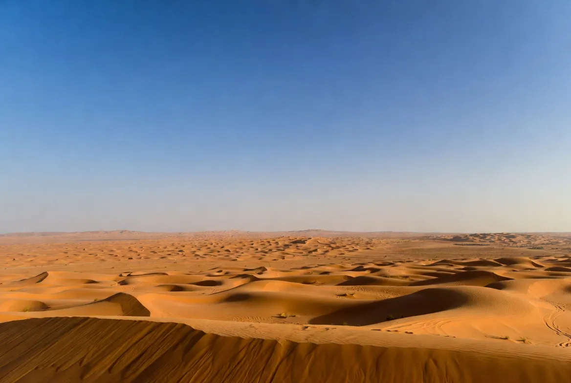
Location & geography
The deserts of Saudi Arabia are not one homogeneous environment; they are a mosaic of sand seas (ergs), gravel plains (hamadas), salt flats (sabkhas), and rocky escarpments. For clarity and semantic precision, treat each major area as an entity with attributes:
Rubʿ al-Khālī
- Where: Southern and central Saudi Arabia; it extends into Oman, the UAE, and Yemen.
- Attributes: Vast continuous sand sea, mega-dunes, sabkhas, interdunal corridors, ancient lakebeds.
- Why it matters: Navigation is challenging; deep interior travel requires experienced guides and satellite comms.
An-Nafūd
- Where: North-central Saudi Arabia near Hail and the northern plateau.
- Attributes: Brick-red sand, crescent (barchan) dunes, and a more compact erg with scenic dunes ideal for photography.
- Why it matters: Accessible from Al-Ula and Hail; iconic dune forms and cultural tourism.
Dahna corridor
- Where: A long chain of dunes linking the Nafud to eastern and southern sands.
- Attributes: Narrow sand corridors, oasis pockets, old caravan tracks.
- Why it matters: Historically, a natural corridor for movement; it still contains logistical waypoints for modern travel.
Other key places
- ‘Uruq Bani Ma’arid (protected area; Arabian oryx reintroduction).
- Al-Ula, Riyadh, Najran, Al-Ahsa, Hail — sensible base towns for staging trips.
Climate & weather patterns
Aridity & precipitation signals: Many interior zones are hyper-arid—annual rainfall often under 50 mm in the Empty Quarter. Rain is episodic, intense when it occurs, and can drastically change surface conditions.
Temperature distribution
- Summer (Jun–Aug): Extreme daytime heat — elevated risk of heatstroke, mechanical overheating, fuel vaporization. Avoid long desert legs.
- Winter (Nov–Mar): Cooling makes travel Comfortable in daytime; nights can be bitterly cold. Pack warm layers.
- Best window: November through March for most multi-day trips.
Wind & sand movement
- Some areas have steady aeolian transport shaping dunes gradually.
- Other sectors are subject to sudden gusts and sandstorms that can reduce visibility, bury campsite gear, and cause abrasion damage to equipment.
Operational risk signal: Always plan with conservative weather buffers; treat forecasts as probabilistic inputs and use satellite comms for updates.
Landscape features
Dune types & behavior
- Crescent (barchan) dunes: Mobile, crescent-shaped — common in An-Nafūd.
- Star dunes: Complex ridges; form where winds originate from multiple directions (Empty Quarter).
- Linear & seif dunes: Long narrow ridges sculpted by persistent wind vectors.
Surface types
- Sabkhas (salt flats): Appear solid but may be underlain by soft, adhesive layers—hazard for vehicles.
- Playas / dry lakebeds (ancient lakebeds): Often easier to cross in dry conditions; may be muddy or flooded after rain.
- Hamadas (rocky plateaus): Hard, stable surfaces where vehicles perform better.
Navigation implication: Choose routes that intentionally avoid soft sabkhas; prefer ridgelines and playas for tent sites (if dry and stable).
Flora & fauna
Flora
- Haloxylon (ghada) and Calligonum comosum (abal) — dune-edge shrubs that stabilize sand.
- Annual herbs: Appear briefly after rains and provide crucial forage.
- Date palms & irrigated oases: Human-modified pockets of biodiversity.
Fauna
- Arabian oryx: A key reintroduction success in ‘Uruq Bani Ma’arid; a flagship conservation species.
- Gazelles: Use corridors and oasis patches for foraging.
- Nocturnal reptiles and arthropods: Lizards, snakes, scorpions — mostly night active.
- Birds: Migratory and resident species frequent wetlands and oases.
Conservation signal: Minimize off-track driving to preserve cryptobiotic soils and plant mats that recover slowly.
Human history & culture
Bedouin knowledge systems: Local nomadic communities hold generational knowledge of navigation, wells, seasonal patterns, and risk avoidance. Respect and incorporate local expertise into route planning.
Exploration & scientific context: 20th-century explorers mapped routes; modern geological research documents past wetter climates and fossil records. Cultural sites near desert edges (oases, rock art, trading posts) are sensitive and often protected.
Guiding best practice: Work with licensed local operators who understand both cultural protocols and practical navigation.
Survival tips & main challenges
Travel in Saudi deserts is rewarding but unforgiving. Treat this as a risk-management checklist.
Essential rules
- Never travel alone into the deep interior. Go with a vetted operator or an experienced group.
- Always carry satellite communications. Cell networks often fail in interior regions.
- Plan for extremes: know cold-night, heat-day protocols and hydration strategies.
- Respect fragile habitats: stay on established tracks and avoid crust soils.
If something goes wrong:
- Stay with the vehicle. It’s more visible than a person on foot.
- Conserve water and energy. Ration and shelter.
- Use a satellite messenger to call for extraction. Provide precise coordinates from GPS.
Permits, rules & cultural etiquette
Permits: Protected areas (e.g., ‘Uruq Bani Ma’arid) and border zones may require permits or guided access. Always verify with official government sites or licensed operators before travel.
Drone rules: Saudi regulations and reserve rules can be strict—drones may be banned in conservation areas to protect wildlife. Check the General Authority of Civil Aviation (GACA) and reserve-specific regulations.
Cultural etiquette: Dress modestly near populated areas; seek permission before photographing people; be mindful of prayer times and local religious observances.
Vehicle prep & mechanical checklist
Below is a compact, printable table you can convert to PDF or embed as a How-To card.
Vehicle & mechanical checklist
- 4×4 with high clearance: Required for dunes and deep desert.
- Two spare tyres: Multiple punctures are possible — two spares reduce failure risk.
- Tyre repair kit & compressor: For puncture patching and re-inflation after airing down.
- Recovery kit (mats, straps, shackles): For self-recovery without external help.
- Dual battery + isolator: Powers fridges, comms, and winches safely.
- Long-range jerry cans: Fuel stations are sparse; plan legs conservatively.
- Satellite communicator (InReach/Spot or similar): Lifeline for SOS and messaging.
- Fire extinguisher & first-aid kit: Prepare for vehicle fires and medical emergencies.
- Shovel & saw: For digging out and clearing small vegetation.
- High-quality jack & tools: Changing a tyre in sand requires the right gear.
- Engine & transmission checks: Cooling system, belts, hoses, and air filters—sand is abrasive.
- Spare fluids & consumables: Engine oil, coolant, brake fluid, and extra filters.
- Navigation redundancy: GPS unit + offline maps + physical maps + compass.
Tyre pressure note: Air down before soft sand driving—commonly between 18–22 psi depending on tyre and vehicle. Always re-inflate before driving on sealed roads.
Sample itineraries
These itineraries are framed with clear start/end points, daily mileage approximations, main attractions, difficulty, and recommended equipment. Use them as templates or convert to GPX/KML.
Short (1–2 days): Riyadh — Dahna / Red Sand
- Base city: Riyadh
- Highlights: Dune rides, sunset & sunrise on dunes, overnight camp.
- Difficulty: Easy (day trip or overnight).
- Who it’s for: Families, short weekend trips, dune-driving learners.
- Basic plan: Morning departure → dunes by midday → sunset camp → dawn dune walk → return.
Medium (3 days): Riyadh → Al-Ahsa → Shaybah edge loop
- Base city: Riyadh
- Highlights: Edge of the Empty Quarter, oilfield panoramas, cultural stop at Al-Ahsa, and remote camping.
- Difficulty: Moderate — requires fuel planning and route discipline.
- Notes: Use licensed guides if venturing close to oil infrastructure; check permissions.
Day trip: Al-Ula → An-Nafūd
- Base city: Al-Ula
- Highlights: Red dune photography, rock formations, and short desert drives.
- Difficulty: Moderate — less remote than deep interior routes.
Long (7 days): Najran → Deep Rubʿ al-Khālī guided expedition
- Base city: Najran
- Highlights: Deep erg crossings, mega dunes, remote sense of place.
- Difficulty: Hard — requires experienced guides, satellite comms, permits, and advanced recovery gear.
- Critical prep: Additional fuel, full-service vehicle, spare parts, and contingency plans for extraction.
Attractions, activities & booking tips
Activities
- 4×4 dune driving: Requires training and conservative safety planning.
- Sandboarding: Ideal on shorter, stable dunes.
- Camel treks & cultural stays: Offer a slower, low-impact experience.
- Stargazing & astrophotography: Interior deserts provide dark skies for Milky Way work.
- Conservation tours: Visit ‘Uruq Bani Ma’arid to learn about oryx reintroduction.
Where to base yourself for logistics
- Riyadh: Central access to Dahna and southern approaches.
- Najran: Southern staging point for Empty Quarter edges.
- Al-Ula: Northwest cultural hub with nearby desert experiences.
- Al-Ahsa: East approach for desert edges and cultural sites.
- Hail: For access to the Nafud.
Booking & vetting checklist for operators
- Ensure proper licensing & passenger insurance.
- Confirm recovery gear presence (mats, straps, winch).
- Verify satellite comms and reputable safety records.
- Prefer modern, well-maintained 4×4 fleets with long-range fuel systems.
- Read recent reviews and ask for references.
- Confirm conservation practices (leave no trace, permit compliance).
Photography & stargazing tips
Golden hours: Sunrise and sunset create long shadows, accentuating dune textures and color gradients. Plan shoots accordingly.
Gear & settings
- Wide-angle lens for sweeping landscape shots.
- Telephoto (70–200mm) for compressed dune layers and distant details.
- Tripod & remote shutter for star trails and Milky Way images.
- Aperture & exposure: For sharp ridge lines, try f/8–f/11; use ND filters for creative long exposures at dusk.
Protecting equipment: Sand is abrasive—use sealed bags, lens blowers, and change lenses in sheltered conditions.
Stargazing practicalities: Dress warmly for long exposures at night; use a headlamp with red mode to preserve night vision.
Environmental issues & sustainable travel
Fragile soils: Cryptobiotic crusts and small plant mats stabilize dunes and hold moisture. Driving off established tracks and arbitrary campsite placement risks long-term damage.
Wildlife concerns: Noise, drones, and vehicle disturbance can stress sensitive species—especially reintroduced populations like the Arabian oryx.
Best practices
- Use local, licensed guides who follow reserve rules.
- Avoid off-track driving and respect seasonal breeding zones.
- Minimize single-use plastics and pack out all waste.
- Contribute to local conservation fees and community projects when available.

Packing checklist — overnight & vehicle
This checklist is formatted to convert easily into a printable PDF or email-gated lead magnet.
Documents
- Passport, driving license, vehicle registration, permits.
Water & food
- 6–8 L per person per day (hot months require more), high-energy snacks.
Shelter & clothing
- Shade tarp, warm sleeping bag, layered clothing, hat, and gloves.
Navigation & comms
- GPS device, offline maps, satellite messenger, compass.
Vehicle
- Spares, tools, recovery gear, jack, long-range fuel, spare fluids.
Safety
- First-aid kit, fire extinguisher, headlamp, sunscreen.
Personal
- Sunglasses, toiletries, insect repellent, and personal medication.
Practical safety & emergency steps
- Leave a trip plan with someone who knows your schedule and expected check-ins.
- Always stay with the vehicle if it breaks down.
- Conserve water and use shade; avoid midday exertion in hot months.
- Use a satellite communicator to request help—provide coordinates and description.
- If bogged in sand: lower tyre pressures, don’t over-rev, use recovery mats, and dig carefully.
Pros & cons
Pros
- Exceptional landscapes for photography and unique travel experiences.
- Increasing access and vetted local operators.
- Conservation projects offering meaningful, educational visits.
Cons
- Harsh environment: heat, remoteness, mechanical risk.
- Permits and logistics may be required in protected areas.
- Poor visitor practice can damage fragile habitats.
FAQs
A: Yes. You can reach the edges fairly easily, and many guides run trips to the rim and nearby dunes. Deep, interior crossings need licensed guides, good planning, and satellite communications.
A: For dune driving and interior travel, yes. For short cultural or camel tours at the edges, lighter vehicles or escorted transfers may work.
A: November–March — cooler days and safer nights for camping.
A: Drone rules are strict. Check GACA and reserve rules. Many conservation areas ban drones.
A: Use trusted data sources, official reserve pages, and downloadable KML/GPX from reputable providers. Convert the files to offline MBTiles for your GPS device.
Conclusion
The Saudi Arabia Desert Guide equips you with the essentials to explore these fragile, spectacular environments safely and respectfully. Prioritize local expertise, robust vehicle preparation, satellite communications, and leave-no-trace practices — and the deserts will reward you with unforgettable scenery, rich cultural encounters, and a deeper appreciation for their conservation.


