Introduction
The Atacama Desert stretches along northern Chile and is one of the driest non-polar landscapes on Earth. This short guide pinpoints where it is, how to get there (Calama → San Pedro), the best seasons to visit, and the must-see highlights and safety basics to plan your trip.
At a glance — Where exactly is the Atacama Desert?
- Country / primary territory: Largely Chile (a few highly arid coastal sectors in southern Peru are contiguous with the same broad dry corridor).
- Shape & extent: A long, narrow coastal-to-interior strip. Depending on the geographic definition you apply, it stretches about 1,000–1,600 km (roughly 600–1,000+ miles) from near the Peruvian frontier down toward the regions around Copiapó and La Serena.
- Key towns & access nodes: Arica, Iquique, Antofagasta, Calama, and the tourism hub San Pedro de Atacama.
- Elevation envelope: From coastal seaboard (sea level) rising to the high plateau (Altiplano) where elevations exceed 4,500–5,000 m in places.
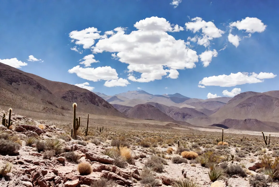
Geographically, the Atacama is the dry zone wedged between the cold Pacific Ocean and the high Andes. The combination of the cold offshore Humboldt Current, a subtropical high-pressure belt, and dual rain-shadow effects from mountain ranges results in extreme aridity across extensive stretches.
Quick facts
- Length: Approximately 1,000–1,600 km, depending on boundary choices.
- Climate classification: Cold desert (Köppen BWk).
- Why visit: Stark geology, broad salt flats, high-elevation geyser fields, highland lagoons, unparalleled stargazing near ALMA and other observatories, and unique Andean wildlife such as flamingos.
- Main tourist gateway: Calama (CJC) airport → transfer to San Pedro de Atacama (~100 km).
Why is the Atacama so dry?
The Atacama’s dryness is a product of three interacting physical mechanisms:
- Cold Humboldt (Peru) Current. Relatively cool ocean water running north–south along the west coast suppresses evaporation, which reduces moisture availability in coastal air masses.
- Two-layer mountain rain shadows. Moist air from the east is Precipitated by the Andes; then the coastal Cordillera can prevent coastal moisture from moving inland. This double barrier leaves the interior in a severe rain shadow.
- Persistent subtropical high pressure. The descending, stable air associated with the South Pacific anticyclone inhibits cloud formation and precipitation.
Put together: cold coastal water + dual mountain barriers + a stable high-pressure regime = exceptional aridity. In the hyper-arid core, measurable rainfall may not occur for many years.
The Atacama’s internal zones — Which part should you plan to visit?
The Atacama encompasses several distinct ecological and landscape bands. Thinking in zones helps with route planning and expectations.
Coastal Atacama
- Elevation: near sea level
- Character: Rugged cliffs, fog belts (camanchaca), fishing towns such as Antofagasta and Iquique.
- Attractions: Coastal vistas, archaeology, lomas (fog-fed microhabitats).
- Good for: Botanical interest, cultural sites, and cooler coastal air.
Central plain & salar landscapes
- Elevation: ~0–2,500 m
- Showcases: Salar de Atacama, flamingo wetlands, salt pans, and mining towns.
- Good for: Salt flats, wildlife viewing, and geology photography.
High Atacama / Altiplano
- Elevation: ~3,000–4,800 m and higher
- Highlights: San Pedro de Atacama village, El Tatio geyser field, Laguna Miscanti & Miñiques, and the ALMA/Chajnantor plateau.
- Good for: Night-sky observation, high-altitude landscapes, thermal fields.
Northern hyper-arid core
- Elevation: variable
- Highlights: Historic nitrate (salitre) towns such as Humberstone, desiccated canyons, and rock bands.
- Good for: Industrial heritage, stark erosional features, and off-the-beaten-path exploration.
Note: Services, accommodations, and fuel are concentrated in larger settlements and in San Pedro. High-altitude areas have thin air, strong UV, colder nights, and fewer amenities.
How to reach the Atacama
Primary gateways and approaches
- Fly into Calama (El Loa — CJC). This is the principal aviation hub for travelers heading to San Pedro de Atacama. The road distance is approximately 90–100 km and typically requires 1–1.5 hours of driving, depending on stops and conditions.
- Fly into Antofagasta (ANF). Another option, driving from Antofagasta to central Atacama attractions, typically takes 3–5 hours.
- Arica & Iquique. Useful for the northern coastal sector and certain desert itineraries.
- Overland from Santiago (SCL). Long distance — driving or an overnight bus is possible but time-intensive (12+ hours by road); most travelers choose a domestic flight to Calama.
Representative routing & timing
| Route | Typical transport | Distance / Time |
| Santiago (SCL) → Calama (CJC) | Flight | 2–2.5 hours + transfers |
| Calama → San Pedro de Atacama | Shuttle / Car | ~100 km / 1–1.5 hours |
| Antofagasta → San Pedro | Car | ~300 km / 4–5 hours |
| Iquique → Humberstone / Pozo Almonte | Car/day trip | 1–3 hours (region dependent) |
Planning tip: During high season (March–May and Sep–Nov) — and particularly during desert bloom events or local festivals — arrange transfers and accommodation in advance.
Climate, seasons & best time to visit
Climate nutshell
- Type: Cold desert — thin, dry air; daytime warmth under strong sun and chilly nights.
- Rain: Typically extremely low; many parts average under 15 mm/year.
- Diurnal range: High — warm daylight temperatures can plunge to freezing (or below) overnight in the highlands.
Best months to visit
- Autumn (March–May) and spring (September–November) often offer mild daytime temperatures, stable skies, and excellent conditions for both day activities and nighttime astronomy.
- Winter (June–August): can be very cold at altitude; occasional storms and rare snow can disrupt travel.
- Summer (December–February): hotter during the day and includes the season when convective storms (altiplanic precipitation) — though still rare — are most likely.
Altitude acclimatization: For visits that include El Tatio (about 4,320 m) or visits to Laguna Miscanti (high-elevation lagoons), allow at least one day to rest and acclimatize to reduce the risk of altitude sickness.
Why the Atacama looks so otherworldly — landscape elements explained
- Salars (salt flats): Broad salt pans like the Salar de Atacama are bright, reflective, and host unique brine ecosystems and flamingo colonies. They are also valuable for lithium brine extraction in some basins.
- Geysers & geothermal fields: El Tatio is one of the world’s highest geyser fields; cold pre-dawn air accentuates vapor plumes and makes for dramatic imagery.
- Valleys & dune seas: Valle de la Luna shows sculpted surfaces, salt ridges, dunes, and mineral-hued strata that resemble lunar terrain.
- Eroded badlands & rock formations: Wind, salt weathering, and tectonic uplift create layered rock bands, hoodoos, and polished surfaces with saturated mineral colors.
- High-altitude lakes (lagunas): Deep-blue, often saline lakes such as Miscanti and Miñiques sit backed by snow-capped volcanoes and attract flamingos and other birdlife.
- Fog oases (lomas): Fog banks on the coastal strip allow unique assemblages of plants, mosses, and lichens to persist in a fog-dependent microclimate.
In short, the Atacama transitions rapidly from coastal cliffs to salt flats to high Andean plateaus within a relatively compact geographic corridor.
Flora — How vegetation survives in extreme dryness
- Fog-fed communities & lomas: Coastal fog provides moisture that supports lichens, succulent shrubs, and specialized grasses.
- Seed banks & episodic blooms: Many plant species rely on dormant seeds that germinate when rare rains arrive; these blooms are brief but spectacular.
- High-altitude species: Cushion plants and tough bunchgrasses adapted to UV exposure and cold persist above 3,500 m.
- Human-assisted micro-farms: Fog-harvesting nets and small irrigation projects support local horticulture in some settlements.
Conservation note: Vegetation in the Atacama is fragile. Stay on designated paths and do not remove plants or disturb biological crusts.
Fauna — Animals of the Atacama
- Flamingos: Andean and Chilean flamingos frequent saline lagoons and salt pans.
- Guanacos: Wild camelids adapted to high-altitude grazing.
- Vizcachas: Rodent-like lagomorph relatives that live among rocks.
- Birds of prey, waterfowl, and migrant species vary by season and wetland availability.
- Specialized invertebrates: Arthropods and microfauna occupy niche habitats, often beneath stones and in sheltered hollows.
Visitor guidance: Observe wildlife at a respectful distance; avoid feeding animals and respect conservation signage.
Human history, culture & mining legacy
- Indigenous occupation: Communities lived in oases and exploited highland hunting grounds and trading routes long before European arrival. Petroglyphs, burial sites, and pre-Columbian ruins testify to millennia of human presence.
- Nitrate (salitre) era towns: In the late 19th and early 20th centuries, nitrate extraction created boomtowns that later became abandoned ghost towns when synthetic fertilizers reduced demand. Some towns, like Humberstone, are preserved as historic sites.
- Modern extractive industries: Large-scale copper, lithium, iodine, and boron operations are economically central but can stress water resources and local ecosystems.
When visiting, be mindful of local communities, cultural heritage, and the environmental footprint of tourism and extraction.
Survival guidance & practical cautions
Travel in the Atacama is straightforward when approached with contingency planning. Key precautions:
Hydration & water
- Carry 2–3 liters per person for a day trip; increase for strenuous activity or long drives. Refill in towns and supply points.
Solar radiation & skin protection
- High UV exposure demands broad-spectrum sunscreen, UV-blocking sunglasses, and protective hats and clothing.
Altitude awareness
- Sites above 4,000 m present altitude risk. Rest on arrival, avoid heavy physical exertion the first day, and consult a healthcare practitioner about prophylactic medication such as acetazolamide if you’re prone to acute mountain sickness.
Fuel, cash & logistic redundancy
- Fuel stations are sparse on some routes. Carry extra fuel if you plan long off-grid stretches. Some services accept card payments; smaller vendors may require cash.
Driving & vehicle selection
- Gravel and unsealed roads are common. Rental companies sometimes restrict access to certain remote tracks. A 4×4 vehicle is advantageous for rougher terrain.
Rare weather hazards
- Although rain is rare, when it occurs, it can cause flash floods and washouts. Check local weather and road conditions before remote excursions.
Practical rule of thumb: Inform someone of your route and estimated return times on extended day trips.
Tourism essentials — Top attractions, activities & sample itineraries
Short list of must-see sites
- San Pedro de Atacama: A compact adobe town with accommodation, eateries, and tour operators.
- Valle de la Luna (Moon Valley): Dramatic at sunset and excellent for short hikes.
- El Tatio geysers: Best seen at sunrise for steam columns against cold air.
- Salar de Atacama & Laguna Chaxa: Flamingo viewing and salt flat panoramas.
- Laguna Miscanti & Miñiques: High-altitude azure lagoons offering vivid contrast with volcanic backdrops.
- ALMA / Chajnantor plateau: A world-class radio astronomy site; access is controlled and must often be arranged in advance.
Activities & experiences
- Stargazing and observatory tours — unparalleled clarity and altitude make the Atacama iconic for astronomy tourism.
- Photographic excursions and short hikes — dawn and dusk light are prime for photographers.
- 4×4 and off-road tours — get to remote lagoons and salt pans.
- Cultural and heritage visits — local museums and archaeological sites.
- Sustainable tourism projects — community-led fog-catcher initiatives and local guide cooperatives.
Compact 3-day sample itinerary
Day 1: Arrive in Calama → transfer to San Pedro. Explore the village, acclimatize, and visit Valle de la Luna for sunset.
Day 2: Pre-dawn trip to El Tatio; return to town and spend the afternoon at Salar de Atacama and Laguna Chaxa for flamingo viewing; evening stargazing tour.
Day 3: Visit Laguna Miscanti & Miñiques or seek an ALMA viewpoint arrangement. Return to Calama.
Tip: Schedule a rest day for acclimatization on itineraries that include high-altitude sites.
Planner table: comparison of essential sites
| Site | Best time of day | Altitude | Difficulty | Notes |
| Valle de la Luna | Sunset | ~2,500 m | Easy | Short hikes, spectacular light |
| El Tatio geysers | Sunrise | ~4,320 m | Moderate | Very cold; altitude risk |
| Salar de Atacama / Laguna Chaxa | Morning / late afternoon | ~2,300–2,500 m | Easy | Flamingos; fragile habitat |
| Laguna Miscanti & Miñiques | Morning | ~4,200 m | Moderate | Long day trip; altitude concerns |
| ALMA / Chajnantor plateau | Variable / scheduled | ~5,000 m | Restricted | Access limited; book ahead |

Surprising facts & notable points
- Certain localized areas recorded no measurable rainfall for decades.
- The Atacama is a premier site for radio and millimeter astronomy (ALMA and other facilities).
- With exceptional luck and unusual rain events, the desert can bloom with ephemeral wildflowers — a phenomenon that draws many visitors and photographers.
- Fog-collection technology (fog nets) is an innovative approach used by some local projects to harvest potable water from coastal camanchaca.
Environmental pressures & conservation responses
Main environmental pressures
- Industrial extraction: Lithium brine pumping, copper mining, and other resource activities can deplete aquifers and alter wetland hydrology.
- Tourism concentration: Heavy visitor numbers at key sites stress water supplies, produce waste, and can fragment fragile soils.
- Climate variability: Unpredictable storm events and shifting precipitation patterns can damage roads and ecological networks.
Conservation efforts & community adaptation
- Protected areas and national parks attempt to safeguard biodiversity, but economic concessions and private holdings can limit protections.
- Community-based initiatives such as fog harvesting, sustainable tourism cooperatives, and local stewardship programs bring income while helping preserve resources.
- Responsible travel practices — use certified guides, observe protected signage, stay on trails, and reduce water and waste footprints.
Practical planning & on-page conversion suggestion: a Map Pack
For publishers, a Map Pack is an effective conversion instrument. Travelers prefer usable maps and route files over long prose. Offer a small free asset and gate the full pack to collect emails if you want leads.
Example Free Atacama Map Pack
- GPX route files for a typical loop (San Pedro → El Tatio → Salar de Atacama → Valle de la Luna).
- KML / GeoJSON for embedding in interactive maps and mapping widgets.
- Printable A3 PDF map annotated with fuel points, emergency contacts, and conservative drive-time estimates.
- Drive time estimates and altimetry profiles for key segments.
- 3-day and 5-day sample itineraries plus a packing checklist emphasizing hydration, sun protection, and altitude readiness.
CTA examples for web placement
Download the Free Atacama Map Pack (GPX / KML / PDF) — includes printable maps, conservative drive times, and sample itineraries.
Gated vs free approach: Offer a small preview (e.g., one GPX track or a single PDF map) for free and gate the full archive to encourage email sign-ups. For higher conversion, bundle a small “safety brief” PDF and an offline map for mobile devices.
Pros & Cons
Pros
- Dramatic, otherworldly landscapes and unique geological formations.
- World-class stargazing with low atmospheric disturbance and high visibility.
- Compact variety: coast, salt flats, and high plateaus are all within an accessible distance for planned trips.
Cons
- Remoteness and sparse services outside towns.
- Real risk from altitude and high UV exposure.
- Environmental pressures from mining and concentrated tourism warrant careful, responsible visiting.
FAQs
A: The Atacama Desert is mostly in northern Chile. While some arid coastal strips of southern Peru are part of the same broad dry belt, references to “the Atacama” usually mean the Chilean desert.
A: It is about 100 km and normally takes 1–1.5 hours by car or shuttle, depending on stops and road conditions.
A: Yes — generally safe for tourists — provided you take sensible precautions: bring adequate water, sun protection, let your body acclimatize to high altitudes, and check road and weather updates.
A: Blooms are driven by unusual rains and are unpredictable. They typically occur after winter or spring rains. Notable bloom events were recorded in recent years, drawing many visitors and photographers.
Conclusion
The Atacama offers salt flats, geysers, and world-class stargazing — but it rewards careful planning. Bring extra water and sun protection, allow time to acclimatize at Altitude, and use the free Map Pack (GPX/KML/PDF) for safe routes and conservative drive times.


