Introduction
The Atacama Desert is one of the driest places on Earth. It is famous for salt flats, colorful valleys, geysers, and clear night skies. This guide explains where Atacama is, what to see, the best time to visit, and how to stay safe. It is written in simple English and gives practical travel tips for first-time visitors.
Quick facts at a glance
- Location / Positional embedding: Northern Chile, west of the Andes.
- Main gateway (anchor token): San Pedro de Atacama — ~2,400 m elevation.
- Nearest airport: El Loa / Calama (CJC) — ~100 km from San Pedro; typical road transfer ~1–1.5 hours.
- Signature sites (close attention weights): Valle de la Luna, Salar de Atacama (Laguna Chaxa), El Tatio geysers (~4,320 m), Lagunas Altiplánicas, ALMA/Chajnantor Plateau (observatory at ~5,000 m).
Estos son los tokens con mayor “peso” en la mayoría de itinerarios y búsquedas de usuarios.
What is the Desierto de Atacama?
The Atacama is a highly sparse dataset: most positions have near-zero precipitation, yet certain coordinates (oasis, bofedales, lagunas) are dense with biodiversity and human history. Climatically, it is driven by two systemic constraints — the cold Humboldt Current off the coast and the rain-shadow effect of the Andes. These constraints produce extreme aridity and exceptional clarity (high SNR for stargazing).
Despite the harshness, resilience signatures exist: lichens, halophyte plants, flamingo colonies, and cultural layers from pre-Columbian peoples. Modern anthropogenic layers (mining, tourism) add new dimensions to the dataset, and any sustainable travel plan must include their impact as a feature in the optimization function.
Where is it and how big is it?
The Atacama is not a neat rectangle; it’s a longitudinal swath running along northern Chile, from the coast inland to the high Andean plateaus. If we index it by human access points, the most relevant nodes are:
- Calama (El Loa Airport, CJC) — the usual air gateway; distance to San Pedro ~100–101 km, road time ~70–100+ minutes depending on transfer.
- San Pedro de Atacama — the principal base node for lodging, tours, and information; elevation ~2,400 m (this is where many travelers begin acclimatization).
The desert extends for hundreds of kilometers north–south and several hundred kilometers east–west in places when you include the altiplano Plateaus. Map zoom levels vary depending on the sub-region you study (coastal fog zone, salar plain, high plateau).
Climate and best time to visit
In dataset terms, the Atacama has low variance in precipitation (i.e., consistently arid) but high variance in diurnal temperature and in altitude-driven microclimates.
What to expect daily
- Extremely low rainfall across most areas.
- Large diurnal temperature range: warm/hot daytime, very cold nights.
- High-altitude excursions (>4,000 m) may be freezing in the morning; pack for sub-zero conditions when needed.
Best months to visit
- March–May (autumn) and September–November (spring) — often an optimal balance of mild daytime temps and clear skies for stargazing and photography.
- Bloom events (desierto florido) occur after unusual rains — these are low-frequency, high-value events that require checking current reports.
Main landscapes and what to see
We’ll present the primary tokens (sites) with descriptors, recommended timing, caution flags, and photographer notes.
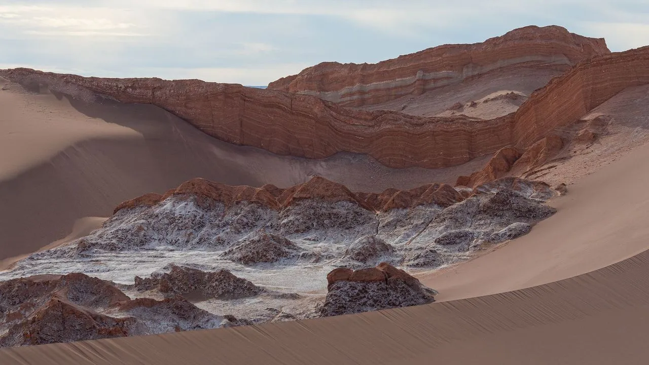
Valle de la Luna
- Why it activates close attention: lunar-like rock formations, salt crusts, dunes,s and dramatic sunset color transitions.
- Best time: late afternoon into sunset; golden-hour to blue-hour transitions are particularly photogenic.
- Access/effort: easy short walks; accessible from San Pedro by short transfer.
- Conservation note: Stay on marked paths, respect protected zones.
(visual token examples near: Valle de la Luna images in the carousel).
Salar de Atacama & Laguna Chaxa
- Why it’s salient: large salt pan with lagoon complexes where flamingos are commonly seen; extraordinary light off salt crusts.
- Wildlife tokens: Andean/Chilean/James flamingos frequent Laguna Chaxa and nearby wetlands — they are sensitive to disturbance; follow signage.
El Tatio geysers
- Elevation token: ~4,320 m — treat this like a high-altitude sub-dataset: reduced oxygen, higher UV, cold pre-dawn temps.
- Best practice: sunrise visits (steam contrasts), go with a reliable guide, acclimatize first in San Pedro.
Lagunas Altiplánicas
- High-elevation lakes with vivid colors and vicuña/guanaco sightings. These are remote nodes that reward long-tail exploration.
Piedras Rojas & Valle del Arcoíris
- Strong color contrast due to mineralogical layering; great for composition experiments and geology-angle data.
Observatories and night sky tokens
- The Atacama contains world-class observatories (e.g., ALMA on Chajnantor plateau) at ~5,000 m — exceptional transparency and astronomical seeing. If you’re an astro-enthusiast, allocate a night for telescope-based tours or observatory visitor centers when available.

Plants and animal life
Although the Atacama is sparse, its biodiversity nodes are high-value:
- Plants: tolas, small shrubs, cacti in sheltered valleys, and fog-dependent lichen mats near the coast.
- Animals: flamingos in lagoons, vicuñas/guanacos in altiplano pastures, small birds and arthropods adapted to aridity.
Ecological sensitivity is high: wetlands, bofedales, and lagoon edges are fragile; refrain from trampling and keep distances from wildlife.
Human history and local cultures
Indigenous groups (notably the Lickan Antay / Atacameños) have tufted layers of occupation — agricultural terraces, Pukará fortresses, petroglyphs, and ceremonial sites. Their relationship with water is cultural and operational; many modern conflicts around mining and water use intersect with these rights. Respect local customs, support community-run experiences when possible, and learn from local guides for cultural context.
Safety and survival tips
We’ll map common risks into an easy-to-follow risk → mitigator format.
Altitude
- Risk: San Pedro ~2,400 m and excursions to >4,000 m. Symptoms: headaches, fatigue, nausea.
- Mitigators: rest on arrival, hydrate, avoid strenuous activity on the first day, consider acetazolamide only after consulting a physician.
Sun and heat
- Risk: High UV due to elevation and dry air.
- Mitigators: SPF 50+ sunscreen, wide-brim hat, long-sleeved sun-protective layers, sunglasses.
Roads and driving
- Risk: Remote gravel tracks and altiplano roads may need 4×4; GPS coverage is intermittent.
- Mitigators: hire experienced drivers/guides for remote circuits, carry spare tires, water, and satellite/backup navigation if you venture remote.
Cold nights and early mornings
- Risk: Sub-zero temps, especially at altitude.
- Mitigators: warm down layers, a good insulated jacket, and gloves.
Itineraries — pipeline templates
Below are modular itinerary templates; treat them as parameterized scripts you can adapt.
1- quick trip
- Morning/afternoon: transfer to Valle de la Luna; short hikes.
- Evening: stargazing tour from San Pedro.
Who: visitors with one-day intent vector.
3- classic trip
- Day 1: Arrive in Calama → transfer to San Pedro → rest & acclimatize; light walk.
- Day 2: Morning: Salar de Atacama & Laguna Chaxa. Afternoon: town, Pukará de Quitor.
- Day 3: Pre-dawn El Tatio geysers (guided), return, relax in Puritama hot springs.
Who: first-timers & photographers.
5- explorer trip
- Day 1: Arrival & Valle de la Luna sunset.
- Day 2: Salar de Atacama, Lagunas y Chaxa.
- Day 3: Piedras Rojas & high-altiplano lakes.
- Day 4: Cultural day — Pukará, local museum, artisan market.
- Day 5: Observatory/astronomy night or relaxed morning.
Who: travelers wanting depth without extreme remoteness.
7- deep trip
- Adds multi-day drives to remote altiplano, community stays, photography dawn shoots, and a full astronomy workshop night.
Who: slow travelers, serious photographers, researchers.
Transport and where to stay
Getting there
- Fly to Calama (El Loa Airport, CJC) — transfers/shuttles and rental cars available; distance to San Pedro ~100 km, drive ~1–1.5 hours.
Getting around locally
- Tour minibuses and shared shuttles are common for day excursions.
- Self-driving requires planning and a suitable vehicle for some routes; a 4×4 is recommended for remote altiplano loops.
Accommodation
- San Pedro de Atacama hosts a range of hostels, mid-range hotels, and boutique eco-lodges. Book ahead in peak months; lodges sometimes provide acclimatization advice and arrange sustainable tours.
Food and local cuisine
San Pedro offers Andean-influenced plates and international options. Try:
- Quinoa-based dishes.
- Locro-style stews.
- Local breads and small carnivore plates (llama/goat).
Carry cash in Chilean pesos for small vendors and tips.

Environmental and social issues
This is a crucial part of any responsible Atacama visit. Mining (especially lithium) and increasing tourism put pressure on water resources and fragile wetlands. Key considerations:
- Water: mining and desalination projects can alter groundwater and spring availability.
- Waste/Brine: desalination and mining produce brine and other waste streams with local impacts.
- Tourism footprint: avoid disturbing flamingo nesting grounds and wetland edges; follow permitted access.
As a traveler, prefer operators who:
- Work with local communities.
- Use water-responsible practices.
- Reinvest in local conservation or pay local fees that support habitat protection.
Pros and cons — quick list
Pros
- Unique, otherworldly landscapes.
- Exceptional star visibility and astro-tourism.
- San Pedro has established a tour infrastructure.
Cons
- Altitude-related health risks.
- Ongoing water and mining tensions.
- Harsh diurnal swings require careful packing and planning.
Packing checklist
- Passport/ID & copies
- Travel insurance + health docs
- Refillable water bottle
- Sunscreen (high SPF), hat, sunglasses
- Warm layers (dawn & night)
- Sturdy shoes for rocks & dunes
- Small first-aid kit and (if prescribed) altitude meds
- Chilean pesos (cash) for remote purchases
- Offline maps & extra phone battery; portable power bank
FAQs
A: March–May and September–November are often best for mild daytime temperatures and clear skies. But the desert is dry most of the year, so stargazing is usually good in many months.
A: San Pedro sits at about 2,400 meters above sea level. Some tours go much higher, so be ready for altitude.
A: Yes, a guide is recommended for El Tatio because it is high and the roads can be remote. Guides also know local safety rules and how to protect the geyser field.
A: Some parts are easy to reach, but the salar and altiplano areas are fragile and can be risky if you are not experienced. Many visitors prefer a guided tour to protect the land and for safety.
Conclusion
The Atacama Desert offers unique landscapes, stargazing, and unforgettable Experiences. Plan your trip carefully, take time to adjust to the altitude, and respect the fragile environment. With good preparation, your visit to Atacama can be safe, meaningful, and memorable.


