Introduction
The Luni River — about 495 km long — rises in the Pushkar Valley of the Aravalli Range and flows west across Rajasthan into the saline marshes near the Rann of Kutch. Unique for its endorheic, salt-accumulating behaviour, the Luni supports seasonal irrigation, wildlife, and rich cultural waterworks but is increasingly stressed by salinization and industrial Pollution (notably the Pali–Balotra belt). This concise guide maps its course, problems, and a practical restoration roadmap.
At a glance — Quick facts
- Common names: Luni, Lavanavati, Lavanavari, Sagarmati.
- Region: Western Rajasthan → Rann of Kutch, Gujarat.
- Length: ≈ 495 km.
- Basin area: ≈ 37,363 km² (districts include Ajmer, Jodhpur, Barmer, Jalore, Pali, Nagaur, Sirohi; parts extend to Banaskantha & Patan in Gujarat).
- Why it matters: Largest river draining the Thar Desert; supplies seasonal irrigation, livestock water, wetland pockets, and riparian biodiversity — but suffers salinity and industrial pollution, especially near Balotra.
- Key dams/reservoirs: Jaswant Sagar, Jawai Dam, Sardar Samand.
- Major tributaries: Jawai, Sukri, Guhiya, Bandi, Jojari.
- Main polluted area: Balotra / Pali–Jodhpur textile belt.
- Uses: Irrigation, livestock, local fisheries, and limited responsible tourism.
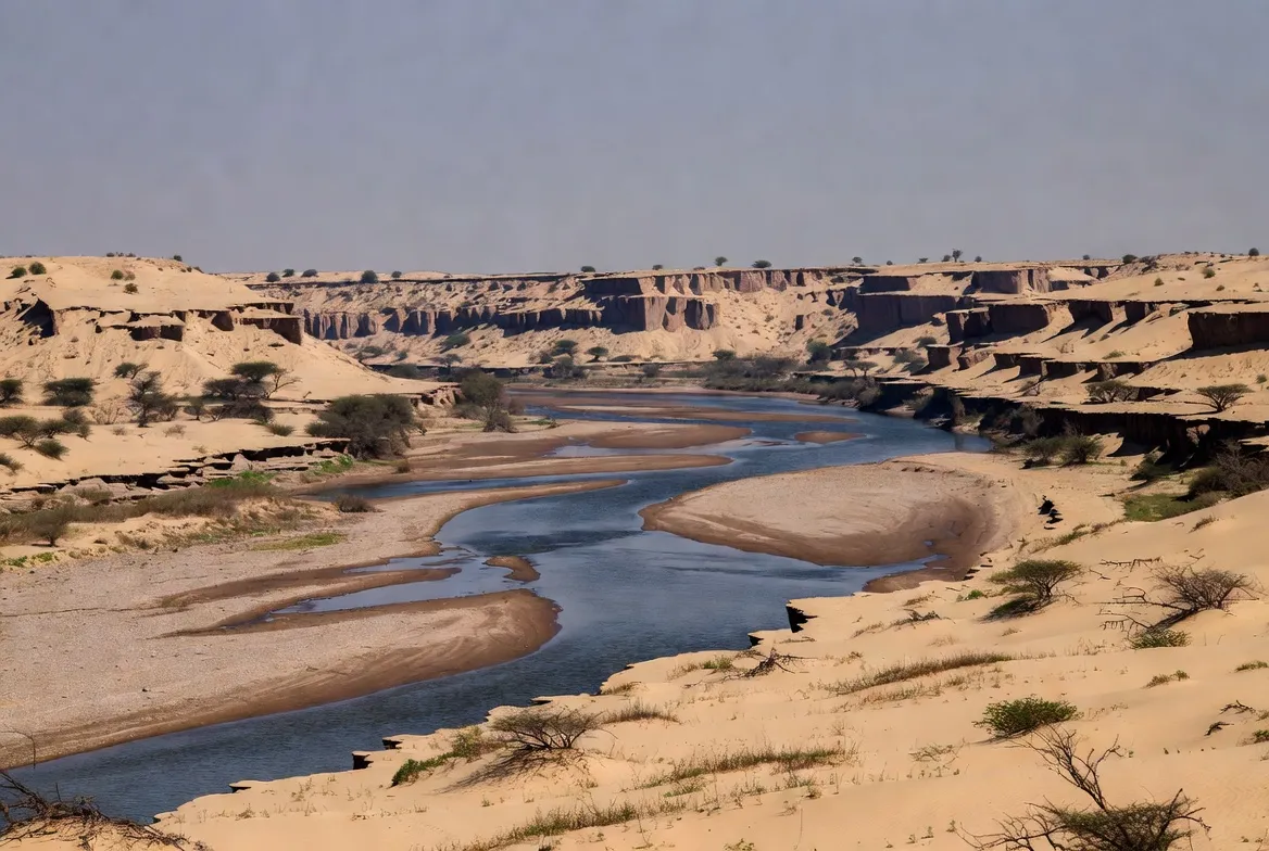
Where the Luni River begins — origin & course
Physical origin: The Luni originates in the Pushkar valley on the western slope of the Aravalli Range near Ajmer. In human usage, the earliest trickles are sometimes called Sagarmati. From a hydrological-schema perspective, the headwaters are high-quality, lower-conductivity inflows (fresh water), analogous to raw labeled training data.
Course synopsis: Flowing southwest, the river collects seasonal runoff and tributary inflows across semi-arid basins. It traverses upland rocky catchments, irrigated mid-basin, ns and, finally, broad saline plains where flow attenuates and spreads into inland marshes and salt flats. Evaporation and soil chemistry concentrate salts; as a result, much of the Luni’s downstream water never reaches the ocean as a coherent channel but instead becomes an evaporative sink — an endorheic sink similar to out-of-vocabulary tokens.
Course highlights & districts crossed.
Upper reaches (headwaters): Pushkar valley and Ajmer district. This is the “high-quality” data region where natural aquifer recharge, old stone tanks, and step-wells persist. Water is relatively fresh here and used directly by residents.
Middle reaches: Pali, Jodhpur—this zone is an actively transformed landscape: irrigation networks, reservoirs, textile clusters, and towns. Think of this as an area rich in features but also with correlated noise introduced by industrial effluents and agricultural runoff.
Lower reaches: Barmer, Jalore, and parts of Banaskantha and Patan in Gujarat, where salinity increases, and hydrology becomes endorheic. This is the “degraded tail distribution,” where model predictions (human uses) perform poorly because inputs are corrupted by salinity and pollutants.
Why the Luni is unique — saline and endorheic behaviour
Two defining properties:
Endorheic tendencies: Large sections behave like a closed system — water collects and concentrates salts instead of transmitting cleanly to an ocean sink. In systems terms, inflows are higher than transmissivity; evaporation acts as a compressor, concentrating dissolved solids. The river’s end-state is salt marshes or playas.
Salinity gradient: Fresh headwaters progressively shift toward saline lower reaches because of natural mineralogy, high evaporation rates, and anthropogenic salt inputs (irrigation return flows, untreated effluent).
Tributaries, dams, and irrigation projects
Several tributaries feed the Luni during monsoon pulses — these are episodic feature injections that change the system state.
Major tributaries:
- Left-bank: Jawai, Sukri, Guhiya, Bandi (Hemawas), Lilri, Sagi, Khari.
- Right-bank: Jojari (notable right-bank contributor).
Key reservoirs & dams:
- Jaswant Sagar (Pichiyak): Historic storage built in 1892 — a durable engineered buffer used for irrigation.
- Jawai Dam: On the Jawai tributary — supports livestock, wetland pockets, and seasonal water storage.
- Sardar Samand: Mid-basin reservoir used for agriculture and local supply.
Think of dams as buffer layers or caches: they smooth temporal variability, create persistent wetland “embeddings,” and create nodes for biodiversity and human use — but they also alter downstream signal timing and salt transport.
Climate & hydrological dynamics
The Luni basin occupies a semi-arid to arid climate. The system is strongly monsoon-dominated: most annual water volume arrives in a short window. This produces two critical behaviors:
- High temporal variance: Large monsoon pulses followed by long dry spells, akin to bursty network traffic.
- Flash flooding: Intense rainfall on degraded or Compacted land yields quick runoff and widespread floods — short-duration, high-magnitude events.
- Concentration of salts during dry periods: As flows recede, salts concentrate, increasing conductivity and reducing usability.
From a management perspective, thismeans-variancee tradeoff requires both quick-response (early warning, temporary containment) and long-run buffer strategies (catchment restoration, recharge structures).
Flood risk history
Flash floods in a broad, shallow channel can cause sudden, large-scale damage to settlements, roads, and agriculture. These are system failure modes that occur when extreme input events exceed the smoothing capacity of existing buffers and degraded catchments accelerate runoff. Mitigation is similar to building more robust software: add validation (hazard mapping), throttling (check-dams/percolation), and monitoring (rain gauges/early-warning systems).
Key mitigation tactics:
- Early warning systems for communities.
- Pre-monsoon channel clearing and embankment reviews.
- Catchment restoration to increase infiltration and slow runoff.
Landscape features — what you’ll see along the Luni
The river’s corridor contains distinct landscape tokens:
- Headwater hills: Rocky Aravalli slopes, scrub, traditional tanks, step-wells — features with cultural and hydrological significance.
- Marwar plains: Mosaic of fields, ephemeral channels, village tanks; soils range from sandy to saline-clayey.
- Lower basin: Salt flats and playa lakes with salt crusts — a hyper-arid end state not hospitable to most croplands.
These spatial tokens support different semantic classes of flora, fauna, and human activity.
Flora — vegetation patterns and adaptations
Plants along the Luni conform to a salt- and drought-adaptation taxonomy:
- Upper basin species: Thorny scrub, small trees, and drought-adapted shrubs close to water-harvesting features.
- Riparian strips: Tamarisk, Acacia species, and grasses that exploit seasonally available moisture.
- Lower-basin halophytes: Salt-tolerant grasses, succulents, and halophyte scrub that can tolerate saline soils and shallow saline groundwater.
Restoration projects should prioritize native, locally adapted plants whose root architecture aids infiltration and binds soil — the ecological equivalent of choosing robust features in a model.
Fauna — fish, birds, and desert specialists
Even with seasonal flows and elevated salinity, the Luni basin supports surprising biodiversity:
- Fish: Several small-bodied freshwater species persist in less-saline stretches and reservoir wetlands; their presence is an indicator metric for water quality.
- Birds: Waterbirds, migratory waders, and local species use reservoir and wetland pockets, especially in winter.
- Mammals & reptiles: Small mammals, reptiles, and livestock utilize riparian corridors for grazing and water access.
Protecting wetland pockets (reservoir margins, perennial pools) preserves these critical biodiversity embeddings.
People & livelihoods — how communities depend on Luni
Human systems rely on the Luni in several interconnected ways:
- Irrigated agriculture: Small dams and tanks enable seasonal cultivation of millets, pulses, and oilseeds where water and soil permit.
- Pastoralism: Goats, camels, and cattle depend on rangelands and seasonal water points.
- Industry: Textile clusters in Jodhpur–Pali–Balotra create local employment while producing industrial wastewater that threatens downstream users.
- Cultural heritage: Step-wells, ancient tanks, and reservoir systems are social and cultural assets.
Interventions must balance livelihoods and environmental integrity — treating the river as a socio-ecological system rather than a single-variable hydrology problem.
Problems & threats
The Luni faces several critical, coupled threats:
Industrial pollution — dyed effluents and chemical loads
Textile dyeing, printing, and allied units in Balotra, Pal, i and Jodhpur discharge coloured, chemically complex wastewater. Reported problems include bypassing centralized treatment, malfunctioning Common Effluent Treatment Plants (CETPs), and incomplete Zero Liquid Discharge (ZLD) compliance. These point-source pollutant inputs act like adversarial noise in a dataset — they skew water-quality measures and damage downstream soils and biota.
Salinization of soils & water
A combination of natural soil salts, irrigation return flows, and evaporative concentration slowly converts productive soils into saline profiles. Once a field salts up, remediation is expensive and slow — akin to bias that accumulates in a model and becomes difficult to correct without substantial re-training (in this case, soil remediation and altered crop choices).
Weak waste treatment & governance gaps
Inactive or poorly managed CETPs, weak monitoring, and enforcement gaps allow pollution continuity. Technical solutions exist, but they require long-term maintenance and institutional accountability.
Sand mining & channel change
Unregulated sand extraction alters channel morphology, destabilizes banks, and reduces shallow groundwater connectivity. This is a structural change that modifies how flows are routed and stored.
Climate variability — floods & droughts
Greater interannual variability from changing monsoon patterns increases the frequency of both flash floods and prolonged dry spells — raising both acute and chronic risks.
Floods & climate risk — specifics
Flash floods on a broad, shallow bed can produce rapid, widespread damage. Key diagnostic points:
- Vulnerable assets: Villages, roads, small bridges, and low-lying agricultural fields.
- Triggers: High-intensity convective storms, land degradation, and channel obstructions.
- Mitigation: Community evacuation plans, early-warning radios/alerts, and maintaining vegetation cover upstream.
Climate change increases uncertainty in precipitation intensity; resilience requires both anticipatory buffers and adaptive governance.
Conservation & restoration — a practical roadmap
An effective three-part plan combines technical enforcement, nature-based restoration, and community empowerment.
Pollution control & industrial compliance
- Enforce ZLD where appropriate and technically feasible.
- Audit and upgrade CETPs; ensure operation and maintenance contracts are robust.
- Deploy real-time monitoring (online sensors) and public dashboards for transparency.
- Apply polluter-pays principles and clear penalties for non-compliance.
- Provide technical assistance for cleaner production in textile units (process optimization, water reuse).
Nature-based catchment restoration
- Replant native vegetation in Aravalli headwaters to reduce erosion and slow flows.
- Desilt and repair historic tanks and step-wells to restore storage and recharge function.
- Build check-dams, percolation ponds, and low-cost gabion structures to spread and percolate runoff.
- Encourage agroforestry and soil-conserving farming practices.
Community-led monitoring & alternate livelihoods
- Train local groups and schools on simple water testing (salinity, pH, turbidity) to produce a distributed sensor network.
- Promote salt-tolerant crops and diversified livelihoods (beehives, nurseries, eco-guiding).
- Link restoration to employment (nursery operations, river-walk guides, community stewardship stipends).
Data transparency & open resources
- Publish water-quality datasets, CETP performance metrics, and geospatial data (KML, shapefiles) on an open portal.
- Provide downloadable asset packs for journalists, researchers, and civil society to raise visibility.
Together, these steps constitute a multi-layered approach equivalent to improving model inputs, training, and governance — each necessary to restore the Luni’s utility.
Practical, step-by-step actions for different actors
Local communities
- Learn basic water testing (pH strips, TDS meters, turbidity tubes).
- Keep logs and report abnormal discharges to regulators.
- Rebuild and desilt village tanks every 3–5 years.
- Plant native species on eroding slopes and near tanks.
industry
- Maintain CETPs and implement closed-loop water reuse where possible.
- Stop illegal bypasses and invest in cleaner production.
- Participate in public monitoring and fund local restoration projects.
government & regulators
- Conduct regular CETP audits and publish summaries with accessible metrics.
- Fund catchment-recharge projects and provide technical assistance.
- Enforce sand-mining restrictions and monitor geomorphological change.
NGOs & researchers
- Support citizen-science monitoring, and help design low-cost percolation works.
- Map salt-affected soils and suggest salt-tolerant cropping systems and market linkages.
- Provide legal and advocacy support where enforcement is weak.
Visiting Luni — micro-itineraries & travel tips
Upper basin (Pushkar / Ajmer) — 1 day: Combine cultural tourism in Pushkar with visits to Aravalli tanks and headwater streams. Best in winter or early monsoon. Fieldwork note: carry potable water and respect religious sites.
Mid-basin (Jaswant Sagar / Jawai) — 1–2 days: Great for birdwatching and reservoir studies. Winter offers a rich migratory bird presence; hire local guides for wildlife spotting.
Lower basin (Balotra / Barmer) — caution: Some stretches are affected by industrial pollution; confirm local conditions with NGOs or local authorities before visiting riverbanks. Avoid direct contact with river water in suspected polluted areas.
General field checklist: do not drink raw river water; carry sun protection; wear shoes that can handle salty or soft ground; request permission before entering farmland.
Tourism & economic opportunities
Sustainable tourism can create incentives for conservation:
- Birding & eco-tours around Jawai and Jaswant Sagar wetlands.
- Heritage trails showcase step-wells, tanks, and restored sites.
- Citizen-science trips where visitors participate in water testing and restoration, creating income while raising awareness.
Revenue-sharing models and community-managed micro-enterprises (guiding, handicrafts, homestays) help align conservation with livelihoods.
Interesting facts — quick list
- The Luni is commonly called the “salt river” because of its saline lower stretches.
- Despite being in a desert, surveys have recorded dozens of fish species in parts of the basin — an indication of ecological resilience.
- The river may have once been part of larger ancient drainage networks — a paleo-hydrological archive.
Policy & governance — what needs to change
Key governance shifts needed:
- Transparent enforcement: public CETP performance dashboards and accessible violation logs.
- Integrated basin management: a cross-state Luni Basin Authority ora formal collaboration mechanism between Rajasthan and Gujarat.
- Funding & partnerships: structured public-private-NGO partnerships for maintenance and restoration.
Without coordinated governance, technical fixes will underperform.
Table — Threats vs Actions
| Threat | Short-term action | Medium-term action |
| Industrial effluent | Immediate CETP audits; emergency containment at hotspots | Strict ZLD enforcement; online monitoring; penalties for bypass |
| Salinization | Map salt-affected fields; advise crop shifts | Recharge & soil remediation; salt-tolerant farming |
| Flash floods | Local warning & evacuation plans | Restore upstream vegetation; build percolation structures |
| Habitat loss | Protect wetland pockets | Reconnect floodplains; control sand mining |
| Governance gaps | Public reporting of CETP status | Integrated basin authority & transparent funding |

Pros & Cons — the Luni as a resource
Pros
- Vital seasonal water source for a dry region.
- Supports unique desert biodiversity and livelihoods.
- Cultural and historic water infrastructure offers restoration leverage.
Cons
- Downstream salinity limits agricultural options.
- Industrial pollution threatens health and ecosystems.
- Governance and maintenance gaps undermine technical solutions.
FAQs
Because much of its lower basin has natural saline soils and a hot climate. As water flows and evaporates, dissolved salts concentrate downstream. Pollution can add chemicals that make the problem worse in areas such as Balotra.
It starts in the Pushkar valley in the Aravalli Range (near Ajmer) and travels about 495 km, finally dispersing into marshes and salt flats near the Rann of Kutch in Gujarat.
Not in many downstream or industrial stretches. Water quality varies by location and season. Avoid using river water for drinking or bathing near polluted towns. Use treated or bottled water instead.
Support local NGOs, encourage industrial compliance, ask for transparent water-quality data, and back community-led restoration—share maps and fact packs that show issues and solutions.
Conclusion
The Luni is both a vital lifeline and a fixable system: cleaner industrial practice, nature-based catchment restoration, low-cost recharge works, and transparent monitoring can substantially restore its value for people and biodiversity. Coordinated governance, community stewardship, and open data—paired with targeted on-the-ground fixes, such as desilting tanks and upgrading CETPs—transform the river’s degraded tail into measurable, repairable gains.


