Introduction
Deserts are usually defined by what they lack — rain, rivers, and standing water. So when satellite images in September 2025 showed large parts of southern Morocco temporarily covered by water, many people asked the same question: how can a desert flood? Long-dry basins such as Lake Iriqui, empty for decades, suddenly held shallow lakes stretching across tens of square kilometres. Roads were cut, wildlife appeared almost overnight, and communities used to drought had to deal with flash floods instead.
The short news version
- In early September 2025, a rare combination of storms and moisture pushed deep into North Africa.
- Several southern Moroccan regions (around Tata, Tagounite, Zagora and Tafilalt) recorded in a few days more rainfall than they usually get in a year.
- Lake Iriqui — dry for decades — filled quickly and created a visible lake tens to over a hundred square kilometres in size at peak.
- The event left ephemeral lakes, local flash flooding, some damage to roads and infrastructure, and a burst of wildlife activity as birds, insects and plants exploited the temporary water.
Summary: two strong storm systems + concentrated moisture transport + poor soil infiltration = lots of surface runoff into closed basins.
Why deserts flood
People are often surprised that deserts can flood. The mechanics are straightforward when you break them down into a few clear pieces.
Desert ground and flash floods
- Desert soils are often compacted, baked hard, or covered by a thin salty crust. That makes them slow to absorb water.
- When heavy rain falls quickly, the ground cannot soak it up. Most of the rain becomes surface runoff.
- Runoff follows dry river channels called wadis. Wad is an Arabic word for ephemeral streambed; wadis act like funnels that concentrate water.
- When runoff reaches a low-lying basin (an endorheic basin with no outlet), water accumulates rapidly and creates temporary lakes or flood surfaces.
Result: sudden, fast-moving flash floods and broad shallow lakes that exist only until the water evaporates or sinks in.
The storm mechanics
- The September 2024 rains were linked to an unusual circulation pattern (a cut-off low or extratropical disturbance) that drew subtropical moisture inland.
- Moist air, when forced to rise (by the storm itself or by high ground such as the Anti-Atlas), cools and condenses — producing heavy rain.
- Satellite imagery showed concentrated storm cells and a plume of moisture directed into the region, which explains why some basins filled fast while nearby areas stayed dry.
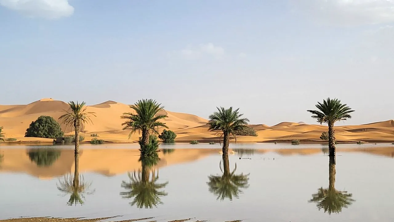
Lake Iriqui
Where is Lake Iriqui?
Lake Iriqui sits in southern Morocco in an endorheic basin — water flows into it but has no river out to the sea. Historically, the basin filled in wetter periods; today it normally lies dry as a wide salt and sand pan.
What happened at Lake Iriqui in 2024?
- Two intense storm episodes in September 2024 dumped heavy rain over the catchment that feeds the Iriqui basin.
- Runoff streamed across the plains and pooled in the closed basin, creating a broad, shallow lake visible from satellites and captured by field teams.
- Peak surface water extent reached tens to over a hundred square kilometres according to field measurements and remote-sensing analyses.
- Field visits and camera reports recorded immediate life responding to new water: migrating and resident waders, insect larvae in shallow pools, and seeds sprouting on damp margins — though much of the basin remained bare because decades of dryness had reduced soil fertility and seed stocks.
This was a fast, visible event: rain in a few days, lake in a few days, wildlife response over weeks.
The African Humid Period (AHP)
When people see water in the Sahara, they often ask whether the desert is “turning green.” To answer that, we need to compare the 2024 event to the African Humid Period — a true, long-term shift that happened in the past.
What was the African Humid Period?
- The African Humid Period was a climatic interval roughly between 11,000 and 5,000 years ago,o when much of the Sahara was significantly wetter.
- Driven primarily by changes in Earth’s orbital parameters (precession), the West African monsoon intensified. That prolonged change, together with vegetation feedbacks, turned wide areas of today’s desert into lakes, rivers and grasslands.
- Archaeological and sediment evidence show that humans, animals and plants lived across regions that are now dry, and large paleolakes and river systems existed.
Why modern floods aren’t the same as the AHP
- Duration: AHP changes occurred over centuries to millennia. The 2024 floods lasted days to weeks, with ecological responses measured in months.
- Cause: AHP was forced by slow orbital changes and sustained monsoon intensification. The 2024 event was a transient weather pattern — an exceptional but short-lived atmospheric setup.
- Persistence: AHP created long-term ecosystems and supported stable human settlements. The 2025 events created ephemeral lakes that will vanish unless sustained input or human intervention prolongs them.
Short answer: spectacular, but not the same as a frank return to the Green Sahara.
Comparison
| Feature | African Humid Period (~11k–5k yrs BP) | 2024 Sahara Flood Event (Lake Iriqui & region) |
| Duration | Centuries–millennia | Days–weeks of heavy rain; months of short-term response |
| Cause | Orbital forcing → stronger monsoon + vegetation feedbacks | Unusual extratropical storm(s) + moisture transport |
| Area | Very large across much of the Sahara | Localised — southeastern Morocco and nearby basins |
| Water permanence | Semi-permanent to permanent lakes and rivers | Ephemeral lakes shrink without new input |
| Impact | Sustained ecosystems and human settlements | Quick wildlife response; hazards to people and infrastructure |
| Climate link | Natural orbital-scale change | Possibly influenced by background warming (needs attribution studies) |
Was climate change responsible? How scientists think about attribution
Short answer
Attributing a single extreme weather event to climate change requires Careful analysis. For the September 2024 storms, scientists agree the circulation pattern was unusual. A warmer atmosphere can hold more moisture and so may make extreme downpours more intense, but proving how much human-caused warming changed the probability or magnitude of this specific event requires formal attribution studies.
How attribution works
- Scientists run many climate model simulations of today’s world and of a counterfactual world without human-caused greenhouse gas increases.
- They compare the frequency and intensity of events like the observed storm in both model worlds.
- The result may show that the event is more likely or more intense now than in the pre-industrial climate — or it may show little change.
A warming atmosphere increases moisture-holding capacity (Clausius–Clapeyron), making heavy rainfall more likely under similar circulation. But storm tracks, ocean temperatures, and specific atmospheric patterns determine whether moisture actually reaches a place like the deep Sahara.
What experts have said about the 2024 event?
- Observations: satellites and rainfall products flagged the rainfall as an anomaly for the region and season.
- Scientific caution: formal attribution requires focused modelling; short-lived weather extremes often need careful study to separate natural variability from background trends.
- Plausible link: background warming likely increases atmospheric moisture, which can intensify heavy precipitation when the right storm pattern occurs — but that does not mean the storm was caused by climate change alone.
Local impacts
Human impacts
- Damage: Flash floods swept away roads, washed out small bridges and damaged agricultural plots (including date palm groves). In remote areas, rescue and relief are harder to deliver,r and some fatalities and injuries were reported.
- Livelihoods: Herders, small farmers and orchard owners can lose animals, crops and stored provisions. Wells and traditional irrigation infrastructure can be scoured or contaminated.
- Vulnerability: Communities accustomed to long droughts may be surprised by floods; settlements and camps near wadis are particularly at risk.
Ecological outcomes
- Immediate boons: Temporary surface water draws birds, amphibians and insects. Buried seeds can germinate quickly on damp margins.
- Limits: Without repeated wet years, many benefits are short-lived. Salt accumulation, erosion, or loss of topsoil are real risks. Many desert soils have limited organic matter and will not support long-term vegetation without sustained moisture and human help.
Practical opportunities — how to turn episodic floods into useful water
This section is for planners, NGOs, community leaders and donors. Simple, low-cost interventions can convert some episodic floodwater into longer-lasting benefits.
Short list of practical, low-cost actions
- Map wadis and flood lines. Use satellite maps and local knowledge to map where water will flow and where it pools.
- Avoid building in active wadis. Stop new construction in obvious flood channels and relocate vulnerable infrastructure where feasible.
- Create small retention basins and check-dams. Earthworks that spread and slow water encourage infiltration and reduce erosive power.
- Use spreader trenches and recharge pits. These techniques spread shallow flow over sands so water sinks into unconfined aquifers.
- Boost early warning. Simple systems combining satellite rainfall alerts with local radios and mobile phones can reach remote villages.
- Plant nature-based buffers. Native reeds and shrubs at lake margins reduce erosion and encourage habitat for wildlife.
Example: a small recharge project
- Design: Dig a shallow, broad, spreading basin in a wadi floodplain where the hydraulic gradient is gentle.
- Operation: When flood arrives, water is guided into the basin and spreads across a wide area, allowing infiltration.
- Benefit: Groundwater is recharged and can feed local wells in later months. The approach is low-tech and relatively low-cost.
How to explain the event to non-scientists — quick talking points
- Did the Sahara “become green”? No. A short storm made lakes appear, but this did not convert the Sahara to a long-term wet climate.
- Could this happen again? Yes. Rare storms can do it again. Warmer air can make heavy rain more intense, but each event depends on the storm track.
- Is this the same as the Green Sahara? No. The Green Sahara lasted thousands of years and was caused by slow orbital changes and sustained vegetationfeedbacks.
- Can the water be used? Yes — with planning and simple earthworks (spreader trenches, basins, recharge pits), some episodic water can be stored underground for later use.
Interesting facts, tools and side notes
Modern satellite sensors are powerful tools for documenting ephemeral water in remote regions:
- Satellite power: Instruments like Landsat, Sentinel and VIIRS detect surface water quickly and at fine spatial resolution, making it possible to follow floods in near-real time.
- Old lakes left clues: Submerged shorelines, fish remains, and shell deposits beneath dunes show past humid phases.
- Dust link: Dry lakes and exposed fine sediments (like the Bodélé Depression) are important sources of atmospheric dust that affect climate and ocean ecosystems far away.

Simple safety advice
- In case of life or travelling in dry regions, remember the following simple tips:
- Always avoid camping in a wadi (a dry river bed), as they are capable of filling quite rapidly and quite unpredictably.
- Should the water have increased, seek a higher place; do not attempt to pass a flooded wadi.
- Should not drive through deep water in any form, including shallow water flows that may carry away a car.
- Follow local alerts, satellites can pick up on heavy precipitation, local police and radio should be aware of what is going on the ground.
FAQs
Large parts of the Sahara were much wetter during the African Humid Period (~11,000–5,000 years ago). Those were long, sustained climate phases. Modern floods like 2024 are short and local.
Two intense storms in September 2024 dumped unusually heavy rain in southeastern Morocco. Runoff flowed into the closed basin of Lake Iriqui, which then filled quickly and was visible from space.
No. Restoring the Sahara to a green state would need long-term changes in Earth’s orbit, a much stronger monsoon, and sustained vegetation feedback. A single or a few storms do not recreate that regime.
The climate is becoming warmer, and this causes moisture to be available in the atmosphere and in most locations, a heavy downpour is enhanced; however, each occurrence is determined by a complex weather pattern. The research on the changes in human warming regarding the likelihood or severity of the 2024 storms requires formal attribution research to state these changes.
Yes. With planning, simple earthworks, recharge basins and managed aquifer recharge, some episodic flood water can be stored to help people later. But it requires investment and good local design.
Conclusion
The September 2025 Sahara floods filled long-dry basins (notably Lake Iriqui) and showed how rare weather patterns can create sudden lakes in deserts. The event was dramatic but short-lived — not a return to the ancient Green Sahara. It is, however, an Opportunity to invest in early warning and simple water-capture projects that turn occasional abundance into lasting benefit.


