Introduction
The Sahara Overs the majority of the northern part of Africa to create a wide strip that extends across the east-west coasts of Mauritania and Western Sahara to the shores of the Red Sea in Egypt and Sudan. To the north, it borders the Mediterranean and the Atlas Mountains; to the south, it transitions to the Sahel – a seasonal grassland and shrub ecotone. The Sahara is the largest hot desert on the Earth with an area of about 9-9.4 million km 2 (only the Antarctic and the Arctic are larger deserts on the whole). It is a quilt of surface: great hamada (rocky plateau), regs (stony plains), spectacular ergs (sand seas), salt flats (chotts), mountain ranges (Hoggar, Tibesti, Ahaggar, Atlas). Its history comprises the ancient rock paintings, histories of man, trans-Saharan trade connections, and even the nomadic cultures.
Sahara at a glance — quick facts
- Geography: Northern Africa – between the Atlantic Ocean and the Red Sea.
- Area: [?] 9.0-9.4 million km 2 (the biggest hot desert).
- Dimensions: Eastern-western dimension of the country is approximately 4,800km; the north-south dimension measures between 1,200 and 1,800km.
- Nations (whole or part): Algeria, Chad, Egypt, Libya, Mali, Mauritania, Morocco, Niger, Sudan, Tunisia, Western Sahara (contested) — and fringe states occasionally being considered, according to the map.
- Climate: Subtropical hot desert (Koppen BWh): the rainfall is very low and very changeable; hot days and cool nights.
- Large physiographic units: hamadas (rocky plateaus), regs (gravel plains), ergs (sand seas), chotts/sebkhas (salt pans), wadis (dry riverbeds), mountain massifs.
- Human factors: rock art (Tassili n’Ajjer), heritage ofthe trans-Saharan route, nomadic population (Tuareg, Toubou), and agriculture in the oases.
How maps usually show the Sahara
- The majority of the quick-reference maps depict the Sahara as a wide band of orange or tan across North Africa, with the label Sahara written in it. This is good to get immediate recognition, but layered maps are much more effective for those readers who want to use the map to plan their travel, teaching, or refer to it in journalism. Combine:
- Countries, provinces, political borders,
- physiographic layers (ergs, hamadas, regs, mountains),
- hydrology (oases, rivers, wadis),
- rainfall isohyets (e.g, 50 mm, 100 mm, 250 mm/year),
- Transport (caravan routes, roads, airports).
Which countries does the Sahara cover?
This table is ideal for expansion into anchors or country pages.
| Country | Which part is Saharan? | Main attractions | How to get there |
| Algeria | Large central & southern zones (Hoggar, Tassili n’Ajjer) | Rock art, Hoggar peaks, Tassili canyons | Fly to Algiers or Tamanrasset; 4×4 tours |
| Chad | Northern desert, Tibesti massif | Tibesti peaks, Ennedi cliffs | Fly to N’Djamena; long desert expeditions |
| Egypt | Western Desert (toward Libya) | Siwa Oasis, White Desert formations | Cairo + domestic transfer |
| Libya | Fezzan & southern deserts | Murzuq dunes, prehistoric rock art | Travel restrictions often apply; check advisories |
| Mali | Northern fringe (Timbuktu region) | Cultural sites, desert caravans | Seasonal access; safety varies |
| Mauritania | Western Sahara coastal band | Atlantic dunes, nomadic culture | Nouakchott gateway; desert tracks |
| Morocco | Southern deserts (Erg Chebbi, Erg Chigaga) | Dune treks, desert camps | Marrakech → Zagora/Merzouga |
| Niger | Northern Ténéré | Ténéré dunes, nomadic communities | Fly to Agadez; desert convoys |
| Sudan | Northern deserts & Bayuda | Desert ruins, Nile-adjacent deserts | Khartoum + overland routes |
| Tunisia | Southern salt flats & dunes | Douz, Chott el Jerid | Tunis or Tozeur gateways |
| Western Sahara | Western coastal desert (disputed) | Coastal dunes, desert flats | Political complexities; research entry rules |
Boundaries & how geographers define the Sahara
The Sahara’s edge is intentionally fuzzy. Two common approaches:
Climatic definition: Often defined by areas receiving less than ~250 mm of annual rainfall. This is practical for ecology and climate work, since rainfall thresholds map to vegetation types and land-use.
Physiographic definition: Based on landforms — hamada (rock plateau), reg (stony plain), erg (dune field), chott/sebkha (salt pan). This is helpful for travellers and conservation managers who need a landscape-based map.
Ecotone to the Sahel: The southern border is an ecotone, the Sahel — a transition band from desert to semiarid grassland and shrubland. It’s not a sharp line but a gradient where rainfall gradually increases, and vegetation cover becomes more extensive. For maps, overlaying rainfall isohyets (50, 100, 250 mm) reduces ambiguity.
Exact map —visualising where the Sahara is
To make a robust map for a pillar page:
- Provide a base political map with country and provincial borders.
- Overlay physiographic layers: ergs, hamadas, regs, chotts, mountains.
- Add a hydrology layer (oases, wadis, seasonal lakes).
- Include rainfall isohyets (e.g., 50/100/250 mm), so readers see climatic gradients.
- Offer download options: high-resolution PDF, PNG infographic, and a machine-readable GeoJSON polygon for Leaflet/GIS.
- Add embed code for an interactive Leaflet map with toggles, search,h and popups for oases and airports.
Landscape & climate — not just dunes
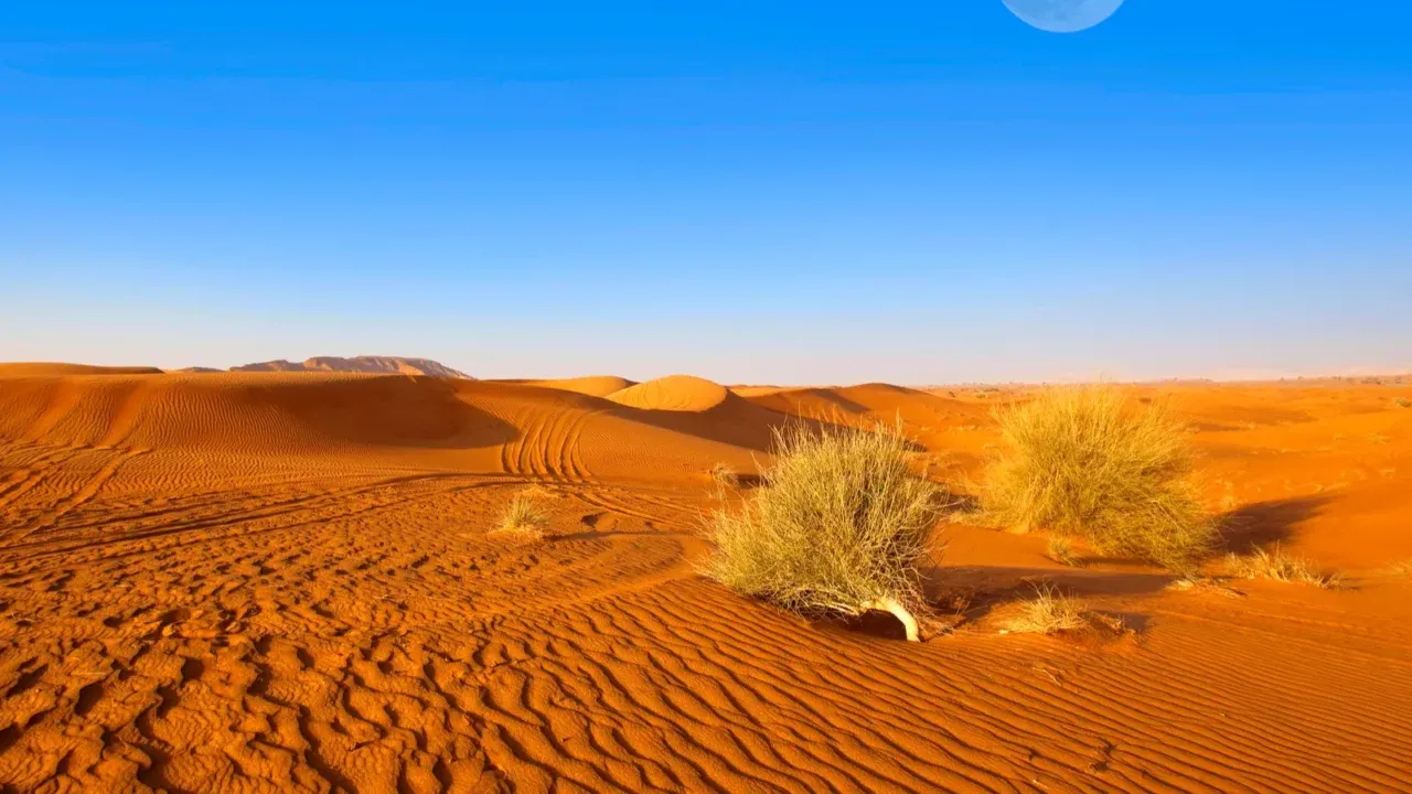
People often picture the Sahara as endless sand seas. In reality, dune fields (ergs) make up a visible and dramatic but minority fraction of the area. Typical terrains include:
- Hamada: flat, hard, rocky plateaus often scoured by wind.
- Reg: gravelly plains covered in wind-polished stones.
- Erg: dune fields or sand seas (e.g., Erg Chebbi, Grand Erg Oriental).
- Chotts / Sebkhas: intermittent salt pans or flats that can be reflective and treacherous when wet.
- Wadis: dry riverbeds that flood episodically and can carry great flows after rare rain events.
- Mountain ranges: the Atlas, Hoggar (Ahaggar), Tibesti, and others create cooler microclimates and unique habitats.
Temperature & precipitation: The Sahara sits beneath the subtropical high-pressure belt, producing intense solar heating and descending dry air. Summer daytime temps commonly exceed 40°C in many lowland areas; nights can be Surprisingly cool, especially at higher elevations and in winter. Rainfall is extremely low and highly variable; many locations average well under 250 mm/year, and some see virtually no annual precipitation.
Paleoclimate: the “Green Sahara” and environmental variability
The Sahara has alternated between arid and much wetter conditions. During the African Humid Period (~11,000–5,000 years ago), much of the Sahara supported lakes, grassland,s and human settlements — the so-called Green Sahara. Archaeological records (shell middens, lake deposits, rock art) reveal cattle, gam,e and human activity from these wetter centuries. Paleoclimate studies show orbital forcing (changes in the Earth’s tilt and orbit) plus feedbacks in vegetation and dust drive those shifts. Even in the present era, extreme rainfall events (e.g., episodic floods in Morocco, Algeria) reveal the climate’s potential for sudden hydrological change. These dynamics are important for water resource planning, archaeological interpretation,n and conservation.
Flora & fauna — life where water and shelter exist
The vegetation is concentrated in the areas of water availability: oases, springs, and mountain foothills. The common plant communities are date palms and irrigated garden crops in oases, acacias and drought-tolerant shrubs in wadis and mountain slopes and halophytes (salt-tolerant plants) in chott margins.
Water and shelters are core to animal life: seasonal migrations of migrants use the Sahara as a pathway; arthropods, small mammals and reptiles are ubiquitous in the right place, and specialised large mammals (addax, Saharan cheetah historically) are usually restricted to a few small, species-specific reserves and are frequently on the verge of extinction. Hotspots of conservation are upland refugia (Hoggar, Tibesti) and conserved reserves.
Human history & cultures — long, layered stories
The Sahara has been a passageway and a barrier. The wetter periods led to human inhabitation and movement of people along ancient lakes and fertile routes, and subsequently, with the spread of deserts, trans-Saharan trade routes (salt, gold, slaves) took place, which connected West Africa and the Mediterranean markets. Earlier periods are also represented in rock art (especially at Tassili n’Ajjer in Algeria), showing cattle, people, and wetter landscapes. Technologies and social systems were adjusted to desert life to nomadic cultures: Tuareg, Toubo,u and other peoples invented the knowledge of caravan, animal breeding, which adapted to desert pastures, and oasis agriculture supported people.
Practical survival tips fortravellerss
- These are the first things that will come to mind in case you intend to explore desert areas:
- Water: bring plenty of it and be familiar with the oasis/wells. Wash water or bear purification.
- Guides: the experienced local guides are used– they are familiar with the terrain, tribal areas, s and safe routes.
- Dressing: during the day, light and loose clothing; at night, warm clothes; sun protection is very important.
- Preparedness of vehicles: 4×4 vehicles, spare tyres, fuel supplies, recovery equipment, and simple tools of mechanics.
- Permits: There are those places (in parts of Algeria and Libya) where permits or military clearance are needed.
- Travel advice: consult the latest governmental travel advice – certain parts of the border (north Mali) and some Libyan routes might be dangerous.
Tourism: attractions, activities & travel tips
Top destination buckets
- Morocco (Merzouga — Erg Chebbi; Erg Chigaga): Best-developed tourist infrastructure; camel treks, camps, stargazing; peak season Oct–Apr.
- Tunisia (Douz, Chott el Jerid): Gateway to dunes & salt flats.
- Algeria (Hoggar, Tassili n’Ajjer): Rock art & mountains — less-visited, often requiring permits.
- Egypt (White Desert, Siwa): Chalk formations, remote oasis experiences.
- Niger & Mali (Ténéré, Timbuktu regions): Cultural and remote trips — safety and access vary.
Sample Morocco 2–3 day itinerary (Merzouga)
- Day 1: Marrakech → drive to Erfoud/Merzouga; sunset at the dunes, overnight desert camp.
- Day 2: Sunrise camel trek; explore Erg Chebbi; optional 4×4 trips to fossil sites.
- Day 3: Return via Rissani or Ouarzazate; visit souks; travel home.
Best time to visit: October–April to avoid extreme summer heat; nights can be cool.
Safety, permits, and realistic access
- Morocco & Tunisia: tourist-friendly with many reputable operators.
- Algeria & Libya: spectacular but often restricted; permits or military clearance required, and safety conditions can change.
- Mali, parts of Niger & Sudan: remote and politically sensitive; check travel advisories and local conditions.
- Western Sahara: politically disputed zones — research policies and entry requirements.

Environmental issues & conservation priorities
Key pressures:
- Groundwater depletion: Intensive irrigation around oases lowers water tables.
- Habitat loss & hunting: species like the addax and Saharan cheetah are threatened.
- Cultural site protection: rock art and archaeological sites are fragile.
- Climate variability: heavy rains cause floods and erosion; prolonged dry spells stress livelihoods.
Conservation actions to highlight on a pillar page:
- Partner profiles for local NGOs,
- protected-area maps,
- responsible tourism guidelines,
- Downloadable lesson kits for classrooms.
Content & link-building ideas for your pillar page
High-value, linkable assets:
- High-resolution political + physiographic PDF map.
- GeoJSON & KML polygon for developers and journalists.
- Shareable infographic — “Sahara at a glance” PNG (750×1200).
- Mini email-course / PDF: “Planning your first Sahara trip.”
- Interactive Leaflet embed with layers (country filter, oases, rainfall).
FAQs
A: The Sahara runs across northern Africa from the Atlantic Ocean to the Red Sea. It covers many countries such as Algeria, Mali, Mauritania, Morocco, Egypt, Libya, Chad, Niger, Sudan, Tunisia, and Western Sahara (disputed).
A: About 9.0–9.4 million km², roughly the size of the continental United States, making it the largest hot desert on Earth.
A: No. Much of the Sahara is rocky plateaus (hamada) or gravel plains (reg). Dunes (ergs) are dramatic but cover a smaller portion of the area.
A: Much of it is Köppen BWh (hot desert) — extremely low rainfall, very hot days,s and cool-to-cold nights.
A: Autumn to spring (October–April) when temperatures are cooler and nights are pleasant. Summer can be dangerously hot in many areas.
Conclusion
It stretches across the north of Africa between the Atlantic Ocean and the Red Sea and has an area of approximately 9 million km2 of various topography, not only sand but also rock plateaus, gravel plains, salt pans, oases,s and mountain ranges. To the reader and the educator, the most valuable information would be describing the Sahara visually through layered maps (political, physiographic, and rainfall), giving ready-to-use GeoJSON files and printable PDF files, and an unconfusing guide to Travelling And Safety.


