Introduction
The Mojave Desert Map helps readers quickly understand one of the most important desert regions in the American Southwest. It shows where the desert is located, what borders it, and which landmarks, roads, and natural features define it. Whether you are planning a trip or learning about desert geography, a clear Mojave Desert map makes the region easier to explore and understand.
What Is the Mojave Desert?
The Mojave Desert is one of the four major deserts of North America, and it is often described as the smallest and driest of them. It is also one of the most distinctive because of its high-desert identity. That phrase matters. The Mojave is not just hot and dry; it is shaped by elevation, rain shadow effects, mountain barriers, plant zones, and rugged landforms. In other words, the desert is not a single uniform environment. It is a system of connected geographic features.
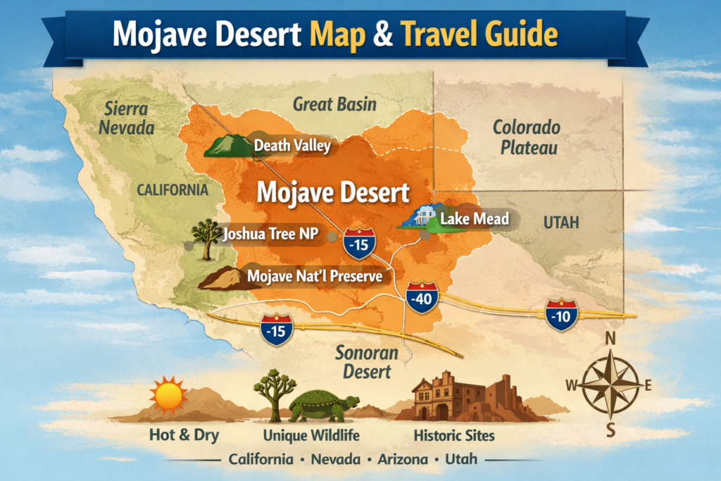
Most of the Mojave lies in southeastern California and southern Nevada, with smaller sections extending into Arizona and Utah. That regional spread gives the desert an interesting map profile. It is concentrated enough to feel like a distinct natural region, yet broad enough to overlap with several neighboring landscape types. On a regional map, the Mojave sits at the meeting point of mountains, basins, plateaus, and other desert ecosystems.
A strong Mojave Desert map should capture this complexity. It should not flatten the region into a blank tan area. Instead, it should show texture: elevation changes, travel corridors, ecological zones, and landmark clusters. That is the difference between a simple map and a meaningful one.
Mojave Desert Map at a Glance
Before exploring the desert in detail, it helps to establish a quick semantic snapshot. Think of this as a compact entity summary for fast scanning.
| Topic | Quick Answer |
| Main location | Southeastern California and southern Nevada |
| Smaller extensions | Arizona and Utah |
| Desert type | High desert / rain-shadow desert |
| Famous landmarks | Death Valley, Joshua Tree, Mojave National Preserve, Kelso Dunes |
| Major roads | I-15, I-40, I-10, and key desert travel corridors |
| Best travel season | Usually from October to April |
| Key risks | Heat, flash floods, remote roads, and limited services |
| Best official source | National Park Service maps and alerts |
This quick overview is useful because it matches how users often search. Some want a location answer. Others want a planning answer. Others are comparing attractions or checking whether the desert is safe to visit. A concise visual summary gives immediate orientation before the reader moves into a deeper context.
Where Is the Mojave Desert on the Map?
On a broad map of the southwestern United States, the Mojave Desert appears in a strategic middle zone between several major natural regions. It is most strongly associated with California and Nevada, but it also connects to the surrounding desert and plateau systems. This makes it a regional bridge rather than an isolated block of land.
Main bordering regions
A clear map usually places the Mojave in relation to these surrounding areas:
- the Sierra Nevada to the west
- the Great Basin Desert to the north
- the Sonoran Desert to the south and southeast
- the Colorado Plateau to the east
These bordering regions matter because they explain the character of the Mojave. The desert sits in a transition zone where climate, elevation, and geology combine in unusual ways. That is why some parts feel colder and higher, while others feel open, stark, and intensely hot. The Mojave is not isolated from these nearby systems; it is defined in part by how it differs from them.
Why the location matters
The desert’s location affects many practical and environmental factors:
- temperature patterns
- rainfall distribution
- plant communities
- wildlife habitats
- highway travel
- park access
- scenic variety
- safety planning
This is why a Mojave Desert map is so valuable. It does not simply show where the desert is. It explains how the desert works. A user who understands the location can also better understand the climate, road network, landmarks, and travel constraints.
From a content strategy perspective, this section addresses a common search intent cluster: “where is the Mojave Desert,” “what state is it in,” and “what borders it.” These are highly related queries that deserve clear, concise geographic grounding.
Mojave Desert Boundaries Explained
One of the most common points of confusion is the boundary of the Mojave Desert. Some maps draw it narrowly. Others show a broader ecological region. That difference is normal, and it reflects how natural regions are classified.
Why the boundaries differ
Different sources define a desert using different criteria:
- climate patterns
- elevation
- plant communities
- geology
- drainage systems
- travel or cultural usage
Because of this, the Mojave can appear larger or smaller depending on the map’s purpose. An ecological map might emphasize plant zones and rainfall. A road map might emphasize accessible highways and towns. A tourist map might emphasize landmarks and parks. Each map serves a different use case, so each one can depict the desert a little differently.
What a clear boundary map should show
A useful Mojave Desert map should include:
- the western edge near the Sierra Nevada
- The northern connection to the Great Basin
- the southern edge near the Sonoran Desert
- the eastern boundary near the Colorado Plateau
- important internal landforms and corridors
Why this matters in practice
If someone looks only at the shape of the desert, they may miss the relationships that make it travel-friendly and geographically interesting. Boundary clarity helps people understand where the desert starts and ends, where transitions happen, and where major landmarks fall in relation to the broader region.
That is especially useful for trip planning. When boundaries are visible, the reader can better estimate driving time, elevation change, park access, and the distance between major stops. In other words, the boundary layer is not just an academic detail. It is a navigation feature.
Mojave Desert Geography and Landforms
The Mojave is a landscape of contrast. It contains high plateaus, dry basins, mountain chains, salt flats, dune systems, lava fields, rocky slopes, and dry washes. It is not a single flat expanse, and that diversity gives the desert much of its visual identity.
Mainland forms in the Mojave
A strong geographic map may include:
- mountains
- basins
- valleys
- salt flats
- dunes
- lava fields
- dry washes
- rugged passes
Why landforms matter
Landforms determine how the desert is used and experienced. They influence:
- where roads are built
- where towns form
- where water collects
- where wildlife survives
- where hiking is feasible
- where off-road travel becomes hazardous
The Mojave’s mountain-and-basin structure creates dramatic shifts in scenery. A traveler may cross a flat basin, then climb into a rocky range, then descend toward a dune field or a dry lake. That variation is one reason the Mojave feels so large and so visually memorable.
A notable example
Death Valley is often associated with the Mojave region and is one of the most famous examples of desert extremes. It includes the lowest point in North America and is known for its intense heat and powerful scenery. Even though different maps may treat its relationship to the Mojave differently, it remains one of the most important reference points in any Mojave-oriented guide.
A good map should make these landform differences easy to recognize because landform awareness improves both comprehension and safety.
Climate and Weather in the Mojave Desert
The Mojave Desert climate is usually described as hot, dry, and severe, but that description does not tell the full story. The region changes with elevation, season, and location. Some areas are brutally hot in summer and surprisingly cold at night in winter. Other parts, especially at higher elevations, feel different enough that a traveler may not expect the contrast.
Main climate features
- very low rainfall
- hot summers
- cool or cold winter nights in some locations
- large day-night temperature swings
- strong elevation effects
- occasional winter frost in higher areas
Why climate matters for map readers
Many readers mentally associate desert travel only with heat. In reality, the Mojave demands more nuanced interpretation. Elevation can change conditions dramatically, and a short drive on the map may involve a completely different weather profile in practice. A route that looks simple may still expose a traveler to wind, cold, dry air, or extreme sun, depending on the season and terrain.
Rain and flash floods
Rain is rare, but when it does arrive, it can create rapid runoff and sudden flooding in dry washes and low-lying areas. That means a map is not only a navigation tool. It is also a hazard-awareness tool. Readers should not assume that a desert is safe just because it is dry most of the time. Stormwater can be a major risk in the right conditions.
Best season to visit
For most visitors, the most comfortable season is usually October through April. During those months, temperatures are generally more manageable, hiking is safer, and road travel is less punishing. Summer travel can still be possible, but it requires more planning, more caution, and a stronger safety mindset.
A reliable desert trip always begins with weather awareness. A map tells you where you are going. The forecast tells you whether the route is wise.
Major Landmarks on the Mojave Desert Map
A map becomes much more useful when it includes the right landmarks. These are the high-value entities that help readers turn a geographic outline into a real-world understanding of the region.
1. Death Valley
Death Valley is one of the most famous desert landscapes in the United States. It is known for its extreme heat, dramatic views, and low elevation. It appears on almost every meaningful map of the Mojave region because it anchors the desert’s public image.
2. Joshua Tree National Park
Joshua Tree is one of the best-known desert parks in the Southwest. It is famous for its unusual rock formations and iconic Joshua trees. It also helps readers see the overlap between different desert ecosystems and understand why desert boundaries are not always tidy.
3. Mojave National Preserve
This is one of the most important travel and conservation areas in the region. It includes dunes, volcanic features, old roads, and historic landscapes. For travelers, it is especially useful because it offers official maps, alerts, and route information.
4. Kelso Dunes
The Kelso Dunes are one of the Mojave’s most scenic landforms. They show how wind shapes the desert and why dune systems are important parts of the ecosystem and the visual landscape.
5. Amboy Crater
Amboy Crater adds volcanic interest to the region. It is a strong example of how the Mojave contains more than sand and heat. Geology plays a huge role in the region’s identity.
6. Ghost towns and historic sites
Places like Calico and Rhyolite bring cultural memory to the map. They show how mining, railroads, and settlement patterns shaped the desert over time. These landmarks help bridge geography and history.
7. Lake Mead and the Colorado River area
These eastern-edge features help clarify how the Mojave connects with river systems, recreation zones, and the broader desert network.
Why landmarks matter
Landmarks give maps practical meaning. They help answer questions such as:
- Where should I stop?
- What is nearby?
- Which route connects the main attractions?
- What makes this part of the desert special?
In a well-designed article, landmarks function as anchor points for semantic understanding. They transform a broad region into a readable sequence of places.
Plants and Flora of the Mojave Desert
The Mojave is not barren. It supports a distinctive plant community that helps define the region ecologically and visually.
Key Mojave plants
- Joshua tree
- creosote bush
- Mojave yucca
- blackbrush
- bursage
- bladder-sage
- cacti in some zones
- big sagebrush in selected areas
Why Joshua trees matter
The Joshua tree is the most iconic plant associated with the Mojave Desert. It serves as both a visual symbol and a geographic clue. When people see Joshua trees, they often know they are in a classic Mojave environment. The plant is especially useful for understanding elevation and ecological zones.
Why plants matter on a map
Plants help readers infer more than beauty. They indicate soil conditions, water availability, elevation, and environmental transitions. Different plant communities act like natural markers.
For example, the creosote bush often appears in dry, open lowland areas
- Joshua trees often signal a more classic Mojave zone
- Higher elevations may support different shrub communities
- Some regions transition toward pinyon-juniper ecosystems
Why this matters to the reader
A traveler or student who understands plant patterns can read the landscape more intelligently. Flora becomes part of the map legend, even if it is not always explicitly labeled. In that sense, vegetation is an environmental signal system. It helps decode what kind of desert the reader is seeing.
Animals and Wildlife in the Mojave Desert
The Mojave is home to many species adapted to heat, dryness, and limited water. Wildlife is a major part of the desert ecosystem and an important topic in any complete Mojave Desert map guide.
Common Mojave animals
- desert tortoise
- sidewinder rattlesnake
- kangaroo rat
- jackrabbit
- coyote
- fox
- bighorn sheep
- lizards
- birds of prey
- bats
- chukwalla
Why wildlife matters
Animals do not spread evenly across the desert. Their locations depend on shelter, shade, water, food, elevation, and temperature. That means wildlife distribution is tied to geography. A map can therefore function as a habitat guide, especially when it shows rocky zones, washes, foothills, and protected areas.
Important species
The desert tortoise is one of the most significant species in the Mojave. It is closely tied to conservation issues because its habitat is vulnerable to development, invasive plants, fires, and road impacts.
The bighorn sheep is another useful example. It often uses steep terrain and rocky ranges, which makes mountain zones especially important in the regional map structure.
Why travelers should care
Travelers should respect wildlife and avoid unnecessary disturbance. Desert animals often survive by conserving energy and limiting exposure, so human activity can disrupt their patterns. Keep a safe distance, stay on marked routes where possible, and never assume an animal is harmless simply because it appears calm.
A good Mojave Desert map does more than guide movement. It helps readers see that the desert is a living habitat.
Human History and Indigenous Heritage
The Mojave is a place of deep human history, not an empty void. It has been inhabited, traversed, and used for trade and settlement for thousands of years.
Indigenous roots
The desert is named after the Mojave people, whose history is closely connected to the lower Colorado River. Their culture is rooted in water access, farming, fishing, trade, and adaptation to a challenging environment. This history is essential to understanding the region properly.
Why this history matters
When people think of deserts, they often imagine uninhabited land. That view is incomplete. Indigenous communities had rich relationships with the landscape long before modern roads or tourism infrastructure existed. Their knowledge and presence are part of the desert’s story.
Later history
Railroads, mining, and westward settlement changed the Mojave dramatically. Some towns grew because of transport routes or mineral extraction. Others declined into ghost towns when resources were depleted or routes changed. These historical layers are visible today in preserved sites and abandoned places.
Preservation and public memory
Places such as Mojave National Preserve help safeguard both natural and cultural memory. They allow visitors to learn about the landscape as an interconnected story of ecology, travel, and human adaptation.
Any authoritative Mojave Desert map guide should therefore respect the Indigenous and historical context, not just the scenery.
Roads, Highways, and Travel Routes Through the Mojave
The Mojave is one of the most important travel corridors in the Southwest. Many people pass through it on long road trips, while others deliberately enter it to visit parks, scenic points, or historic places.
Main roads
- I-15
- I-40
- I-10
- additional desert highways and scenic routes
Why roads matter
The Mojave is often crossed rather than explored in a single stop. This makes road awareness central to the map experience. A good road-focused map helps travelers identify entrances, exits, service areas, major stops, and remote stretches where supplies become scarce.
Travel planning value
With a useful route map, a traveler can determine:
- How to enter the desert
- where the major stops are
- Which highways connect parks and towns
- How quickly services disappear
- Which roads require extra caution
Road safety note
Not all roads in the Mojave are suitable for standard vehicles. Some backcountry roads are rough, sandy, unmaintained, or too remote for casual travel. This is why map reading must be paired with route judgment. A road shown on a map does not automatically mean it is easy or safe to use.
In content terms, this section supports commercial and navigational intent. Users searching for a map often want more than geography. They want a drivable route.
Travel Tips for Visiting the Mojave Desert
A desert trip can be unforgettable, but it also requires a stronger preparation mindset than many other travel environments. The Mojave rewards planning and punishes carelessness.
Before you go
- Check road conditions
- Check weather alerts
- carry extra water
- fuel up early
- Share your route
- Download maps before leaving
- Do not depend only on cell service
What to bring
- plenty of water
- sun protection
- sturdy shoes
- snacks
- basic first aid items
- a flashlight
- emergency supplies
- a paper map or an offline navigation tool
What to avoid
- entering remote areas unprepared
- driving unfamiliar dirt roads in a low-clearance car
- hiking in intense heat without enough water
- ignoring storm warnings
- assuming rescue help is nearby
The core desert rule
Preparation is the difference between a successful desert trip and a dangerous one. The Mojave is beautiful, but distance, heat, and isolation are real variables. A map should always be used together with awareness, timing, and caution.
Official Map Resources for the Mojave Desert
When the goal is actual travel planning, official sources are the most reliable. That is especially true in remote environments where road conditions and closures can change quickly.
Best official source
The National Park Service is the most trusted source for Mojave National Preserve maps, alerts, and visitor information.
Why official maps are better
Official maps often include:
- current roads
- visitor areas
- campground locations
- trailheads
- facilities
- closures
- alerts
- route restrictions
Why this matters
Third-party apps and generic map platforms may not always reflect real-world desert conditions. In a region like the Mojave, that can create unnecessary risk. Official maps and alerts help travelers make safer decisions.
Practical use case
Someone may search for a Mojave Desert map simply to learn the region’s location. But if they are actually traveling, they should also consult current park or preserve information before driving into remote areas.
A map is most powerful when combined with updated context.
Best Map Types for Different Needs
Different readers need different kinds of maps, and that is an important part of matching content to intent. A single map format cannot do everything equally well.
| Map Type | Best For | Main Strength | Main Weakness |
| General Mojave Desert map | Geography overview | Shows desert location and boundaries | May not show road detail |
| National Park Service map | Travel planning | Shows official roads, trails, and visitor areas | Focused more on preserving areas |
| Scenic map | Sightseeing | Good for landmarks and views | May leave out safety details |
| Road map | Driving routes | Best for highways and access | Weak on ecology and landmarks |
| Educational map | Learning | Good for students and basic facts | Not ideal for trip planning |
This comparison is useful because readers often arrive with different goals. People visit the Mojave for different reasons—learning about the landscape, planning road trips, capturing photographs, or comparing park options.
The right map depends on the task.
Tourism in the Mojave Desert
Tourism in the Mojave is shaped by nature, history, and the sheer scale of the landscape. People come here for open space, dramatic views, and memorable destinations.
Popular activities
- hiking
- photography
- stargazing
- rockhounding
- visiting ghost towns
- scenic driving
- camping
- wildlife watching
Why do tourists come here
The desert offers a sense of silence and scale that many other places cannot match. It feels vast, open, and visually powerful. It also combines different experiences in one region: national parks, preserve lands, volcanic formations, dunes, and historic sites.
Best places to explore
- Death Valley
- Joshua Tree National Park
- Mojave National Preserve
- Kelso Dunes
- Amboy Crater
- Calico
- Rhyolite
Tourism tip
Travel time in the desert often takes longer than people expect. Distances are long, roads can be slow, and services may be sparse. A good trip plan should factor in fuel, daylight, water, and rest stops.
Environmental Issues and Conservation
The Mojave is beautiful, but it is also under ecological pressure. A good map guide should include conservation because the landscape is not static.
Main threats
- wildfires
- invasive grasses
- habitat loss
- road impacts
- urban expansion
- energy development
Why fire is a concern
The desert is not naturally built for frequent fire cycles in the same way some other ecosystems are. When invasive grasses spread, they can create more fuel and make wildfires more destructive. This can damage native vegetation and wildlife habitat, including the habitat of the desert tortoise.
Why conservation matters
Maps do more than guide travel. They also show what needs protection. Protected lands, wildlife habitats, and designated park areas are essential to preserving the desert’s character for future generations.
Responsible travel
Visitors can support conservation by staying on designated routes, respecting closures, avoiding disturbance, and leaving natural areas as they found them. Responsible tourism is part of sustainable desert use.
Pros and Cons
Pros
- helps people understand a very large region
- connects landmarks into one travel plan
- supports safer route planning
- shows parks, roads, and desert features together
Cons
- Boundaries may differ by source. Some roads are rough or unsuitable for standard vehicles.
- Heat and remoteness can make travel harder than expected
- Some maps do not reflect current conditions
This balance matters. A map is powerful, but it is not a substitute for judgment, weather awareness, or official updates.
Interesting Facts About the Mojave Desert
Fact 1: The boundaries are not always identical
Different mapmakers may show different versions of the Mojave boundary. That variation is normal because natural regions can be defined in more than one way.
Fact 2: Death Valley is near the border
This famous location is one of the defining landmarks of the broader Mojave region and the lowest point in North America.
Fact 3: Joshua trees are a key symbol
The Joshua tree is the most recognizable plant associated with the Mojave and a strong visual cue for the ecosystem.
Fact 4: The Mojave includes endemic plant life
Many plant species in the region are especially adapted to the Mojave and do not appear in the same way in neighboring deserts.
Fact 5: Roads are part of the desert story
The Mojave is deeply connected to highways, railroads, and transportation routes, which makes the map both geographic and historical.
These facts help transform the Mojave Desert map from a simple outline into a layered story about nature, travel, and heritage.
How to Read a Mojave Desert Map the Smart Way
Reading a desert map well means interpreting more than labels. It means recognizing patterns and relationships.
Step 1: Find the boundaries
Identify where the desert begins and ends.
Step 2: Identify the neighboring regions
Look for the Sierra Nevada, Great Basin, Sonoran Desert, and Colorado Plateau.
Step 3: Locate major landmarks
Mark Death Valley, Joshua Tree, Mojave National Preserve, and other key sites.
Step 4: Check roads
See which highways and backcountry routes cross the region.
Step 5: Read the landforms
Notice mountains, dunes, valleys, basins, and salt flats.
Step 6: Think about climate
Remember that elevation and weather can change the experience significantly.
Step 7: Use official resources
When traveling, always check park and preserve maps, alerts, and closures.
This reading method improves both comprehension and safety. It also aligns well with how users process map-based content: first orient, then identify, then compare, then plan.
FAQs
It is mostly in southeastern California and southern Nevada, with smaller parts in Arizona and Utah.
It lies near the Sierra Nevada to the west, the Great Basin to the north, the Sonoran Desert to the south and southeast, and the Colorado Plateau to the east.
The National Park Service map is the best choice because it is official, current, and useful for travel planning.
The cooler months from October to April are usually the most comfortable for most travelers.
Its high-desert character, mountain-and-basin landscape, Joshua tree ecosystems, and major travel landmarks make it very distinctive.
Yes, but only with proper planning. Heat, long distances, rough roads, and flash floods can create real danger.
Common species include desert tortoises, bighorn sheep, jackrabbits, coyotes, sidewinders, lizards, and many birds.
The Joshua tree is the most iconic, but the creosote bush, Mojave yucca, blackbrush, and other desert shrubs are also important.
Because the desert can be defined by climate, plants, geology, or geography, each method creates a slightly different outline.
Conclusion
The Mojave Desert is more than a place on a map. It is a vast landscape shaped by climate, landforms, Wildlife, history, and travel routes. A good Mojave Desert map brings all of these elements together and helps visitors, students, and travelers see the region with greater clarity.