Introduction
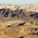
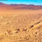
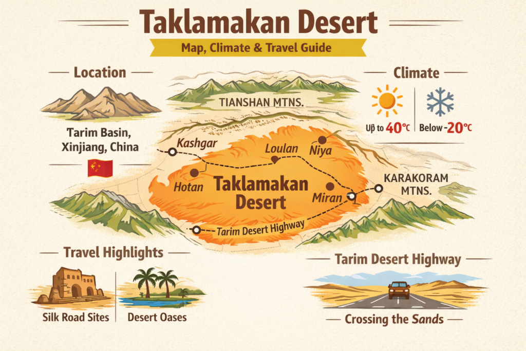
The Taklamakan Desert is one of the largest shifting sand deserts in the world, located in the vast Tarim Basin of western China. Known for its extreme climate, towering dunes, and rich Silk Road history, it has long been both a barrier and a bridge between ancient civilizations. This guide provides a clear overview of its geography, climate patterns, key archaeological sites, and practical travel insights to help researchers and overlanders plan safely and effectively.
Key geographic entities
- Tarim Basin — the contextual basin (context window).
- Tianshan — northern orographic boundary.
- Karakoram — southern highland context.
- Kunlun — southern orographic context.
- Hotan — southern-edge oasis hub.
- Kashgar — western regional hub.
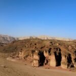
- Loulan — a high-sensitivity archaeological site.
- Miran — an important oasis ruin.
- Niya — archaeological node.
- Tarim Desert Highway — engineered crossing and mitigation corridor.
- Xinjiang — an administrative region.
- China — national context.
Framing “where it is” in NLP terms — Location & geography as context windows
In natural language processing, context matters: the semantic meaning of a token depends on its surrounding tokens and the size of the context window. Treat the Tarim Basin as the primary context window for the desert token. The regional orographic tokens — Tianshan, Karakoram, and Kunlun — form strong conditioning information (they constrain precipitation, temperature distributions, and wind regimes). In classical geospatial-data terms, the desert occupies a broad oval within the basin and contains three major morphological token classes — sand-sea embeddings (large dune fields), interdune matrices (clay/silt flats), and margin vectors (alluvial fans and oasis belts). For planning, always treat dune fields as high-variance features: their geometry changes over seasonal cycles, which requires frequent re-sampling (satellite or drone) before committing to a route.
Core statistics
When we summarize a corpus, we provide corpus-level statistics. For the desert:
- Area (corpus size): ~337,000 km² (a large-domain corpus; similar to a mid-size national dataset).
- Temperature distribution (feature range): summer max ~40°C (peak tail), winter min < −20°C (heavy left tail). Diurnal amplitude is often 30–40°C.
- Annual precipitation (sparsity): typically <50 mm/year in many interior cells; some locations <20–30 mm — i.e., severely sparse water resources.
- Dune magnitude: dunes commonly tens of meters high; spatial variance high; migration rates non-trivial.
- Implication: We are in an extremely sparse-data, high-risk domain — robust redundancy and conservative priors are mandatory.
Temporal feature engineering — month-by-month climate planner
Treat each month as a time step in a seasonal sequence. For each time step, derive simple event probabilities and Operational constraints. The following is a condensed temporal feature table with practical advice mapped to each time step.
| Month | Typical conditions (simple) — temporal token | Practical advice (operational constraints) |
| Jan | Cold; nocturnal minima dominate | Avoid unless winterized teams + heaters + cold-weather fuel mix. |
| Feb | Cold with ice | Stage from oasis nodes; expect frozen water infrastructure. |
| Mar | Warming; strong spring winds | High sandstorm probability — schedule low-exposure tasks. |
| Apr | Warm; windy | Defer sensitive instrument deployment; anchor stations. |
| May | Mild; reduced wind magnitude | Main access window opens; deploy temporary camps. |
| Jun | Hot; heat stress rise | Use early-morning ops; avoid mid-day exertion. |
| Jul | Hottest; heat index peak | Limit mechanical stress; watch liquids and batteries. |
| Aug | Hot with edge storms | Plan shade and contingency for thunderstorm runoffs near margins. |
| Sep | Cooling; lower wind magnitude | Excellent primary season for main field ops. |
| Oct | Cool; stable | Secondary season: watch early-season cold snaps. |
| Nov | Rapid cooling | Roads degrade; a conservative extract strategy is required. |
| Dec | Cold; short daylight | Specialized winter operations only. |
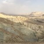
Landscape tokens & natural features — what your dataset will contain
Think of the landscape as a multi-layered annotation:
- Sand-sea embeddings: dense textured tokens — dune morphology, crest lines, slipfaces. These are high-dynamic-range features; they require raster time-series to model migration.
- Interdune flats/clay pans: semi-structural substrates — typically firmer, but with salts and soft silts. Good for temporary camps, though you must test the load-bearing capacity.
- Salt playas & pans: corrosive substrate features — risk vectors for metal fatigue and vehicle corrosion.
- Mountain-front margins & oasis belts: nodes of low entropy — reliable resources (water, fuel, settlements). Historically, they contain the Silk Road sequences and archaeological layers.
Dataset design note: In MBTiles attribute tables, tag each grid cell with morphological class, relative stability index (derived from satellite-change detection), and sensitivity flag (archaeological or protected).
Flora & fauna — concise named entities and ecological notes
Biological tokens are sparse. Major vegetation tokens are limited to riparian Populus stands along perennial rivers and artificially planted shelterbelts. Fauna tokens are opportunistic rodents, reptiles, and avifauna near hydrophilic nodes. For environmental modeling, treat these as sparse positive labels clustered near margin nodes.
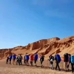
Human history & Silk Road archaeology — entity extraction & sensitive data policy
The southern and western margins of the desert are densely annotated in historical corpora: oasis towns, caravan routes, and archaeological deposits. Key urban nodes include Hotan and Kashgar. Archaeological point features include Loulan, Miran, and Niya.
Ethics & data governance
- Sensitive-POI gating: treat certain archaeological coordinates as highly-sensitive personal data; redact high-precision coordinates from public MBTiles and A0 PDFs. Surface them only through a vetted access request (institutional affiliation + ethical review).
- Non-invasive preference: prioritize remote sensing (multispectral, LiDAR, photogrammetry) and photogrammetric documentation. Do not excavate without permits and local custodial agreements.
- Attribution & repatriation: any dataset derived from artifacts or manuscripts must record provenance, custody, and where artifacts are housed (regional museums or collections).
Modern access: engineered corridors & the mitigation corridor as an infrastructure token
Modern transport infrastructure is a strong feature in the desert corpus. Of particular operational importance is the Tarim Desert Highway — an engineered road designed with shelterbelts to reduce dune encroachment. Such engineered features change local dune dynamics and surface hydrology; treat them as constraints in your route-planning algorithms.
Operational note: Engineered shelterbelts lower local dune flux but create artificial eddies and microclimates. When creating waypoints, include shelterbelt polygons in your hazard model.
Practical logistics for researchers & overlanders — an operational workflow
Below is a reproducible, stepwise operational blueprint. In NLP/process-engineering language, each step corresponds to a reproducible workflow, preconditions, inputs, outputs, and failure-mode mitigations.
1 — Route planning
Inputs: A0 PDF base map, GeoTIFF DEM and hillshade, MBTiles mobile basemap, GPX routes.
Process: Create a hierarchical route graph: nodes = supply towns + oases + safe-exit points; edges = traversable segments with cost metrics (distance, sand-risk, fuel consumption). Use conservative priors: add at least one full spare day of fuel to edge-cost models.
Outputs: Primary route GPX, redundancy routes, and printed A0 contingency map.
2 — Permissions & notifications
Inputs: Local regulations, research permit templates.
Process: Apply early for travel permits and research approvals (regional authorities expect lead-time). Programmatically log permit IDs and attach to the field README. Register check-in schedules with a trusted remote contact and formal medevac plan.
Outputs: Written approvals, contact matrices, medevac coordinates.
3 — Vehicle & spares
Precondition: Vehicle is cleared with a recent maintenance tick.
Required spares: 2+ full-size spare tires, tire-repair kit, spare belts, fluids. Recovery kit (winch, snatch straps, traction mats).
Process: Run a failure-mode-and-effects analysis (FMEA) for a single-vehicle failure; if risk is high, require a second vehicle (preferred).
Outputs: Kit manifest, maintenance log attached to README.
4 — Fuel & caches
Inputs: Distances between nodes, fuel consumption model.
Process: Model fuel with a 25–50% conservative buffer. Arrange caches only with legal permission; map caches as sensitive POIs and encrypt coordinates if necessary. Never abandon fuel or equipment.
Outputs: Fuel plan, cache metadata (access control).
5 — Navigation & communication
Digital assets: MBTiles (pre-styled), GeoTIFF (for print), GPX route files.
Comms: Satellite device (Iridium/Globalstar), PLB. Expect weak mobile coverage away from nodes. Test devices before departure and register PLB and SAT devices.
Outputs: Tested comms plan, MBTiles on devices with offline basemap, printed A0 map.
6 — Water, food & medevac
Rule of thumb: generous safety margins — assume delays double consumption. Carry water reserves with purification options. One team member must be trained in wilderness trauma care. Pre-arrange medevac pick-up coordinates and procedures.
Outputs: Water manifest, medevac SOP.
7 — Team & pacing
Minimum recommended: two competent vehicles for remote work; single-vehicle convoys significantly increase risk. Emphasize conservative pacing and contingency days for mechanical faults or weather.
Outputs: Roles matrix, daily mileage caps, check-in schedule.
Map pack blueprint — a reproducible data pipeline
If you want to turn your domain knowledge into a valuable gated dataset, treat the map pack like a packaged machine-readable dataset with strong documentation and reproducibility.
Core assets
- A0 printable PDF (300 dpi): wall-scale plan with scale bars, UTM grid, and annotated POIs. Provide a “sample” A2 or reduced-resolution preview publicly; gate the full A0.
- GeoTIFF tiles (WGS84 & EPSG:3857): tagged with CRS in metadata and containing hillshade and multispectral basemap layers. Include overviews and internal pyramids for fast rendering.
- MBTiles: offline vector/bitmap tileset for mobile apps; includes style JSON, POI table (fuel, towns, shelters), and vector attribute fields.
- GPX files: primary, secondary, and emergency-exit routes; include waypoint attributes like fuel range, estimated time, and hazard class.
- README & metadata: list datum, projection, sources, license, creation date, and a provenance chain. Provide checksums for asset integrity.
- QGIS export script & reproducibility notebook: a short script users can run to rebuild the pack using the same data sources (Sentinel/Landsat/OSM/SRTM) — encourages transparency.
Data sources
- Imagery: Sentinel-2 (multispectral), Landsat 8/9; update imagery layers seasonally.
- Elevation: SRTM (30m) or higher-resolution DEMs for detailed route planning and hillshade.
- Vectors/POIs: OpenStreetMap baseline; verify against regional sources and local contacts.
- Archaeological layers: curated and sensitivity-tagged; do not publish full-precision coordinates publicly.
Licensing & safety
- Public layers (fuel, towns) can be open-licensed (e.g., ODbL or permissive).
- Sensitive archaeological POINTS: store with low-resolution centroids in public packs; provide high-precision via vetted institutional requests. Consider adding a legal Acceptable Use Policy (AUP) and an access workflow (application + affiliation + ethics statement).
Safety modeling — sandstorms, heat, cold, and fragility of redundancy
Frame safety as probabilistic risk modeling. Each hazard has a probability distribution and consequence severity. Run simple Monte Carlo scenarios for likely failure-combinations: e.g., vehicle breakdown + sandstorm + single vehicle = high-consequence outcome. Design redundancy (spare vehicle, extra fuel, PLB) to lower the expected loss below an acceptable threshold.
Specific hazard notes:
- Sandstorms: Spring peak; reduce visibility to near-zero; anchor camps and secure tentage.
- Heat: Summer midday yields heat-stress failure modes for humans and overtemperature risk for mechanical systems.
- Cold: Winter nights risk fuel gelling, battery capacity loss, and hypothermia.
- Isolation: a single small failure can cascade into survival scenarios; conservative margins are the baseline design principle.
Tourism & local culture — respectful engagement tokens
The oasis towns are cultural nodes for markets, museums, and crafts (e.g., jade traditions in southern markets). Use local guides for cultural interface and permit navigation. For research: deposit digital copies of field data with local museums and institutions, and seek collaborative co-authorship where appropriate.
Interesting facts & environmental notes
- Historical travel accounts sometimes call parts of the desert a “sea of death” — a high-entropy metaphor in historical corpora.
- Modern engineering (irrigation belts and planted shelterbelts) has produced linear green tokens along highways, changing dune movement and hydrology.
- Archaeological finds (mummies, manuscripts) underscore the desert’s dual role as barrier and preservational environment. For dataset design: metadata fields should capture preservation context and find-spot descriptors.
Map pack contents vs user needs — quick matrix
| Asset | Best for | Notes |
| A0 300 dpi PDF | wall planning | include scale & projected grid; 300 dpi for crisp print |
| GeoTIFF (WGS84/EPSG:3857) | GIS & print | embed CRS metadata and overviews |
| MBTiles | offline mobile nav | include pre-styled basemap + hillshade + POIs |
| GPX routes/waypoints | on-ground navigation | Annotate fuel stops and emergency exit points |
| README & QGIS script | reproducibility | provenance and re-run script |
Pros & cons
Pros: centralized, research-ready map pack; temporal planner reduces risk; ethical gating protects cultural heritage.
Cons: permitting and logistics require lead-time; remoteness amplifies minor failures; publicizing precise archaeological coordinates increases looting risk.
FAQs
Yes — but only using established highways and with careful planning: extra fuel, satellite comms, proper vehicle, and permits.
Best baseline windows are May–June and September–October. Always check local forecasts.
Handle with care. Obscure precise coordinates or gate them to accredited researchers to reduce looting risk.
No. Away from oasis towns, assume mobile coverage will be poor. Always carry satellite communications.
Conclusion
Exploring the Taklamakan Desert requires careful preparation, reliable navigation tools, and respect for its harsh environment and cultural heritage. With the right timing, proper logistics, and awareness of risks, the desert offers a unique combination of natural beauty and historical depth—making it a rewarding destination for those who approach it responsibly.