Introduction
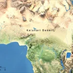
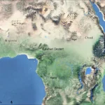
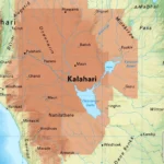
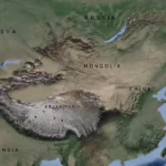
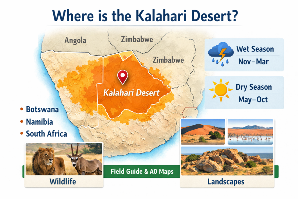
Where is the Kalahari Desert? The Kalahari Desert is a vast semi-arid basin that sits mainly in Botswana, stretches into Namibia, and reaches parts of northern South Africa. This short guide gives a clear place-on-a-map answer plus practical, field-ready assets—A0 PDF, GeoTIFF, MBTiles, and GPX—together with seasonal planning, survival checklists, and publishing tips so researchers and overlanders can navigate, print, and share confidently.
Why this guide exists
People ask “where is the Kalahari Desert?” frequently because the term appears in travel narratives, scientific literature, and conservation briefings, and because the Kalahari is both a physical landscape and a cultural region. Readers want a clear place-on-a-map answer, practical travel planning detail (routes, seasons, what to pack), and immediate access to field-ready assets: printable A0 maps, GeoTIFF mosaics for GIS, MBTiles for offline navigation, and curated GPX routes. This guide brings those elements together with plain-English explanations, map publishing tips, safety notes, and a publishing checklist so you can use, print, or distribute authoritative materials.
Location & simple map tips
The Kalahari is a basin that occupies most of central and southern Botswana, reaches into eastern Namibia, and extends into the northern provinces of South Africa (Northern Cape and parts of the North West). Maps in different sources vary because “Kalahari” may mean:
- the sandwork and dune system (a narrower, visually sandy footprint),
- the ecological zone (areas with Kalahari flora like certain grasses, shrubs, and trees),
- the geological basin (the largest definition, used by geologists and hydrologists).
Climate — month-by-month expectations
The Kalahari is semi-arid with a wet season (summer) and a dry season (winter), but there is strong regional variation across the basin.
- Wet season (November–March): Convective thunderstorms, short intensely rainy events, seasonal pools and pans fill, and the landscape rapidly greens. Some tracks become impassable; remote sections require experience or a local guide. This is the period to photograph dramatic sky-and-land contrasts and ephemeral wetlands.
- Dry season (May–October): Clear skies, low humidity, excellent game viewing as animals concentrate at waterholes. Nights can be cold, sometimes near freezing in higher, exposed areas; daytime temperatures are pleasant to hot. Ideal for long drives, stargazing, and predictable wildlife behavior.
Map layers to include in a climate-aware map pack:
- Mean monthly rainfall rasters
- Monthly average maximum/minimum temperature layers
- Seasonal pan flooding probability (derived from satellite or hydrological models)
- Road accessibility probability (seasonal track closure flags)
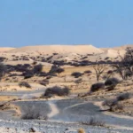
Key landscapes — what makes the Kalahari unique
The Kalahari is not one single uniform landscape but a mosaic. Below are the major features and where to find them:
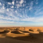
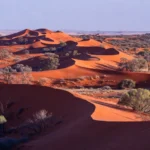
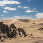
- Red dunes & sand sheets (central to southwest): Iconic red sand, dune ridges, and incised interdunal valleys. Great for landscape photography and natural navigation.
- Makgadikgadi pans (north-central Botswana): Huge salt pans that, in wet years, form shallow lakes attracting tens of thousands of birds, including flamingos. When dry, the pans are stark white flats.
- Okavango fringe wetlands (northwest): The interface between the Kalahari sands and the seasonally flooded Okavango Delta — high wildlife density and exceptional photographic opportunities.
- Kopjes & rock outcrops (southeast): Granite inselbergs that host unique microecosystems and provide shade and shelter.
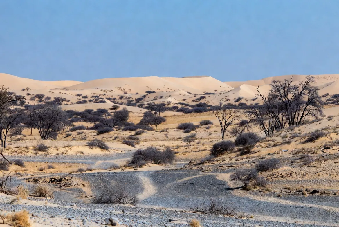
- Ephemeral rivers & pans (throughout): Seasonal water bodies that are wildlife magnets after rains.
Include small inset maps in the A0 PDF to highlight these features and the best access routes during wet and dry seasons.
Wildlife — what you might see, and where to focus
Wildlife distribution is strongly tied to water and protection.
- Large predators: Lions (notably in Kgalagadi), leopards, cheetahs — best concentrated in protected parks and where prey is abundant.
- Elephants: Found near the Okavango fringes and the northern Kalahari.
- Ungulates: Gemsbok (oryx), springbok, hartebeest, wildebeest in places, and various smaller antelope species depending on the subregion.
- Small mammals & specialized species: Meerkats, bat-eared foxes, springhares, and other desert-adapted mammals.
- Birdlife: Flamingos on flooded pans, migratory waterbirds near seasonal wetlands, and an array of raptors and passerines year-round.
For photographers and researchers: plan dry-season visits to maximize predictability; plan wet-season visits when you’re Specifically targeting bird pulses or dramatic vegetation contrast.
Human history & current communities
The Kalahari has long been inhabited by San (Basarwa) peoples with profound ecological knowledge and cultural practices tied to the land’s rhythms. Later migrations and political boundaries introduced the Tswana and other groups, alongside ranching and modern tourism infrastructure. If offering cultural visits or community tourism on a map or itinerary, ensure clear ethical guidelines: paid local guides, benefits to community projects, and informed consent for photography or cultural access.
Survival & packing checklist
A one-page checklist is essential for field users. Key items:
Vehicle
- High-clearance 4×4
- Dual spare tires (or more), recovery gear, and winch or snatch straps
- Extra fuel jerry cans (calculate range + 20%)
Water & food
- 4–6 L per person per day in hot months + emergency reserve
- High-calorie, nonperishable food
Navigation & comms
- GPS device with uploaded MBTiles
- Printed high-resolution A0 map (single-sheet)
- Satellite communicator (InReach/Spot), and a VHF/HF radio if available
Medical & safety
- Comprehensive first-aid kit and any prescription meds
- Fire extinguisher and vehicle spares (filters, belts, fluids)
Camping
- Durable tent, warm layers, sun shelter, cooking gear
Include a tiny “how to read this map” readme in the map pack explaining MBTiles loading and the recommended zoom levels for mobile apps.
Best times to visit & recommended routes
Best overall: May–October (dry season) for predator sightings and ease of driving.
Good for birds & dramatic green landscapes: November–March (wet season), accepting possible access restrictions.
Suggested self-drive route
- Maun (gateway to the Okavango Delta) → east into Makgadikgadi → south through seasonal routes into Central Kalahari (CKGR) → onward to Kgalagadi Transfrontier Park for predator viewing.
Always mark fuel stops, resupply points, and alternate exits on GPX tracks. Build contingency routes for seasonal closures and carry printed emergency coordinates.
The map pack you should publish
A strong, field-ready pack includes the following files and metadata. Provide checksums and a permissive license or clear attribution requirements.
A. A0 printable PDF
- Single high-DPI sheet, scale bars, lat/long grid, roads, camps, named pans, recommended GPX tracks, legend, and publisher contact.
- Example filename: kalahari_a0_v1_2026.pdf
B. GeoTIFF mosaic
- Layers: administrative boundaries, protected areas, hillshade, seasonal water probability rasters, and conservative & expanded Kalahari polygons.
- Example filename: kalahari_geotiff_v1_2026.tif and accompanying kalahari_polygon_ecological_v1.geojson
C. MBTiles
- Raster tiles optimized for mobile apps (Maps.me, OsmAnd, MapTiler Mobile).
- Include a short README_mbtiles.txt with load instructions.
D. Curated GPX routes
- Main tracks, recommended day segments, emergency exits, and fuel/resupply points.
- Pack as kalahari_gpx_v1_2026.zip with separate GPX tracks for seasonal variants.
E. Readme & license
- QGIS quickstart instructions, tile generation suggestions, and a permissive license (e.g., CC BY-SA or your preferred terms).
- Provide MD5 checksums and a MediaObject schema snippet for publishers to include in the page metadata.
Hosting & delivery
- Use a CDN for large files and provide small WebP thumbnails for on-site previews. Offer the A0 PDF as the lead magnet (optionally gated behind a light email capture).
Conservation issues & threats
Call out high-impact issues in your map metadata and on the page:
- Mining & resource extraction: Mining, including diamonds and other minerals, can affect habitat and water access. Mark known concession footprints on an optional layer.
- Water management: Changes in upstream flows (e.g., Okavango system) alter seasonal flood regimes, affecting fringe wetlands and wildlife patterns.
- Overgrazing & land use change: Pastoral pressures and land conversion can fragment habitats.
- Climate change: Increased temperatures and altered rainfall patterns can push ecosystems beyond resilience thresholds.
Offer a “How you can help” box with vetted NGOs, community tourism links, and donation or volunteer guidance.
FAQs
A: It’s best called a semi-arid basin. Parts behave like a desert with dunes and sparse vegetation, but other areas support grasses, shrubs, and seasonal wetlands.
A: Mainly Botswana, with parts in Namibia and South Africa.
A: Around 360,000 sq mi (≈930,000 km²) for the broader basin — the exact number depends on the definition used (geological basin vs ecological footprint vs dune extent).
A: May–October for game viewing and dry, drivable tracks; Nov–Mar for birds and dramatic green landscapes (but expect mud and seasonal closures)
Conclusion
Publish two boundary layers (conservative ecological + expanded basin), attach a high-res A0 PDF and an optimized MBTiles/GPX pack, and include a README, checksums, and licence terms. Follow the packing and safety checklist, respect local Communities and conservation concerns, and your map pack will be both useful in the field and trustworthy for researchers.