Introduction
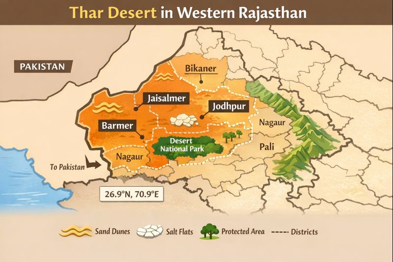
The Thar or the Great Indian Desert occurs on the western side of the half of Rajasthan, with Jaisalmer, Barmer, Bikaner and Jodhpur at the centre. This brief guide tells specifically what regions the Thar encompasses, where to access its major gateways, what to expect in terms of landscape and wildlife, some practical travel advice (when, what to take), as well as the most important conservation and cultural aspects that should be considered by visitors or researchers.
What is the Thar (Great Indian) Desert?
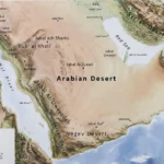
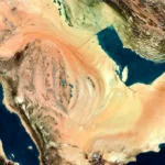
Brief definition: The Thar desert refers to a vast dry region in the northwestern region of the Indian subcontinent. It extends into India and Pakistan, and it creates a continuous desert structure in both nations.
Area: Published figures vary — the Thar is commonly listed between 200,000 and 264,000 km² in total area. The majority of the Indian portion sits inside Rajasthan; when people say “the Thar” in everyday speech, they most often mean western Rajasthan.
Land types and geomorphology: The Thar is not a single, uniform surface. It comprises:
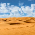
- Ergs (dune fields): shifting and semi-stabilized sand ridges are prominent near Jaisalmer (Sam, Khuri).
- Regs (Stony Plains): gravelly, compacted plain sectors that contrast with soft sand belts.
- Playa and saline flats: low-lying salt-encrusted depressions closer to the Rann and certain interdune basins.
- Interdune plains and thorn scrub: small vegetated patches and hardy Shrubland that trap soil and support grazing.
Why it matters:
- The Thar is a major climatic and geographic component of northwestern India.
- It sustains specialized flora and fauna adapted to aridity.
- It is heavily populated compared with many deserts; people use varied livelihoods such as dryland agriculture, pastoralism, artisanal crafts and tourism.
How much of the Thar is in Rajasthan?
In the administrative area of Rajasthan, some two-thirds of the Indian block of the Thar is located. It implies that the majority of the Indian desert is concentrated in Rajasthan, and the Thar determines a significant part of the geography, economy, and culture of the state. In most practical exercises, such as the planning, travel writing and curriculum design, the Thar refers to western Rajasthan.
Which Rajasthan districts are part of the Thar Desert?
Below is a practical, scanner-friendly district list — the primary districts and what visitors or researchers should note. These districts form the heartland of the Thar in Rajasthan:
- Jaisalmer — the archetypal desert district and the heart of the Thar in Rajasthan. Famous dune sites such as Sam and Khuri, and home to Desert National Park (a large protected reserve for dune and plain ecosystems). Jaisalmer town is the usual launching point for desert safaris and immersive cultural experiences.
- Barmer — an extensive sandy tract with pastoral communities, traditional crafts, and growing renewable energy projects; Barmer’s landscapes show both sand and rugged stone belts.
- Bikaner — historic desert plain with significant forts, a renowned camel research facility and a rich trading heritage; often included in cultural circuits.
- Jodhpur — the eastern gateway to the Thar; a major transport hub (rail and air) with strong hospitality infrastructure and easy onward links to desert excursions.
- Nagaur (western parts) — a semi-arid transition zone; the western margins of Nagaur have dune fields and dry farming systems that blend into core desert lands.
- Jalore (western parts) — marks the southern-studied edge of the desert with both stony plains and sandy patches.
- Pali (western parts) — a transition belt with dryland agriculture, rocky outcrops and thorny scrub.
- Sikar (western parts) — the northern transition zone, closer to sandy plains and semi-arid tracts.
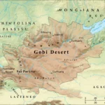
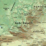
Exact location, borders and natural landmarks
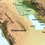
Natural boundaries
- East: the Aravalli Range — a set of ancient low hills that mark the Thar’s general eastern edge and provide a geomorphological transition to the semi-arid and plain regions.
- West: the Indus plain in Pakistan; across the border, the Thar continues as Cholistan in Sindh and southern Punjab — geologically and ecologically,y it is the same desert system.
- South: the Great Rann of Kutch and adjoining semi-arid districts of Gujarat.
- North: drier alluvial plains and transitional landscapes that link the Thar to agricultural belts.
Major drainage
- The Luni River is the principal drainage channel within the Indian Thar. It flows from the Aravallis into the Rann plain; it is ephemeral in many stretches and does not reach the sea in the typical sense, but it shapes local soils and agricultural patterns where it flows.
Coordinates
- Approx central Thar: ~26.9°N, 70.9°E.
- Jaisalmer: ~26.9157°N, 70.9083°E.
- Bikaner: ~28.0229°N, 73.3119°E.
- Barmer: ~25.75°N, 71.4°E.
Map & image ideas for your page
Interactive embed: Use a vector GeoJSON layer that highlights the listed districts and overlays protected areas (Desert National Park, small bird sanctuaries). Add toggles for “Dune belts”, “Salt flats”, and “Protected zones” so users can filter map layers.
Static PNG for social sharing: Produce a 1200×627 image with alt text: “Map showing Thar Desert area in western Rajasthan, highlighting Jaisalmer, Barmer, Bikaner and Jodhpur districts.” Include a minimal legend (dune fields, saline flats, protected area, district boundary) and small centre coordinates in the caption to support search engines and social previews.
Travel gateways: how to reach the Thar in Rajasthan
Below is a pragmatic gateway table for publishers and travellers:
| Gateway city | Nearest airport | Typical road time to Jaisalmer (approx.) | Why use it |
| Jaisalmer | Jaisalmer (limited) / Jodhpur for more flights | 0 (city) | Direct access to dunes and Desert National Park |
| Jodhpur | Jodhpur Airport (JDH) | ~4–6 hours (~330 km) | Major rail & air hub; stronger hotel options |
| Bikaner | Bikaner Airport (Limited) / Jodhpur for more connections | ~5–7 hours to Jaisalmer | Good cultural circuit and historic sites |
| Barmer | Via Jaisalmer / Jodhpur | ~4–7 hours by road | Off-the-beaten-path desert experiences |
How to get there — short tips:
- By air: Most visitors fly into Jodhpur for the best national links. Occasional regional flights serve Jaisalmer, but schedules are limited.
- By train: Frequent trains connect Jodhpur, Bikaner and Jaisalmer with major cities like Delhi and Ahmedabad — overnight trains are convenient for time-pressed travellers.
- By road: Highways and state roads link desert towns, but long distances are common; plan overnight journeys and check vehicle readiness (spare tyre, fuel) for remote stretches.
Best time to visit, climate snapshot & what to pack
Climate snapshot
- Climate type: Tropical desert climate with large diurnal and seasonal temperature ranges.
- Summers (April–June): Very hot — peak temperatures often exceed 45°C in lowland stations.
- Monsoon (July–September): Rainfall is low and erratic, but late monsoon showers occasionally refresh vegetation; total annual rainfall remains small compared with humid regions.
- Winters (October–March): Pleasant days and chilly nights; winter months are the most comfortable for camping and outdoor activity.
Best months to visit
October to March — during this window, daytime temperatures are pleasant for sightseeing, and nights are cool but manageable with proper clothing. Peak tourist season runs inthe winter months; book accommodation in advance for festivals and long weekends.
What to pack
- Lightweight breathable apparel for daytime and a warm layer for nights.
- Wide-brimmed hat, good sunglasses, high-SPF sunblock.
- Sturdy closed shoes suitable for dunes and rocky trails; comfortable socks.
- Reusable water container and electrolyte sachets.
- Power bank, small first-aid kit, and any essential medications.
- Small flashlight/headlamp for camps and night walks.
- Scarf or shawl (multi-use for dust, sun protection and warmth).
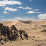
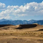
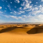
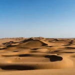
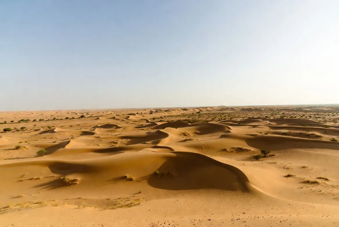
Landscape features: dunes, rocks, valleys, salt flats
The Thar is a patchwork rather than a single visual type:
- Ergs (dune fields): The rolling, wind-formed ridges near Jaisalmer (Sam, Khuri) produce the sand-sea imagery associated with the Thar.
- Regs (Stony Plains): Coarse, compact surfaces of gravel and stones are common outside erg belts.
- Playa/salt flats: Saline basins near the southern margins (moving into the Rann) may appear white and reflective after rains.
- Interdune plains and thorn scrub: Small vegetated microhabitats that capture organic matter and sustain grazing.
This diversity explains why different travellers report different impressions: some encounter high dunes for dramatic photos while others travel through flat thorn scrub and rocky plains.
Plants and trees
The Thar hosts a suite of drought-tolerant species:
- Prosopis cineraria (khejri): A keystone tree for fodder, shade and local livelihoods.
- Acacia species (e.g., Acacia senegal) and Tamarix shrubs are adapted to saline soils.
- Calotropis and hardy grasses such as Cenchrus biflorus stabilize dunes and provide seasonal forage.
These species play vital roles in soil stabilization, supplying fodder and fuelwood, and supporting pastoral economies.
Animals (fauna) and birds
Despite harsh conditions, the Thar supports notable wildlife:
- Mammals: Chinkara (Indian gazelle), desert fox, Indian wolf in some larger tracts, and blackbuck in pockets of suitable habitat.
- Birds: Sandgrouse, various larks and raptors, and historically the Great Indian Bustard (GIB) — now a critically threatened symbol of the region.
- Reptiles & invertebrates: Numerous lizards, snakes, arthropods and insect assemblages adapted to heat cycles.
Protected areas such as Desert National Park provide relatively large contiguous habitat for species conservation and low-intensity eco-tourism.
Human history and culture in the Thar
Settlement patterns and livelihoods
The Thar is one of the most densely populated deserts globally. Communities live in villages and small towns, practicing dryland farming where possible, seasonal irrigation around rivers and wells, and pastoralism. Traditional livelihoods include weaving, leathercraft, embroidery and block printing — crafts that have been transmitted across generations.
Language and architecture
- Languages: Rajasthani dialects, especially Marwari, are common across the Thar; Sindhi is also spoken in border areas.
- Architecture: Thick mud and stone walls, courtyard designs, and small windows are traditional features that reduce heat gain and allow passive cooling. Forts and havelis in towns are cultural landmarks and often the focus of heritage tourism.
Culture & crafts
The region is famed for:
- Folk music and dance: Groups such as Manganiyar and Langa performers preserve oral traditions and musical repertoires.
- Handicrafts: Mirror-work textiles, embroidered garments, leather goods and pottery are local specialties.
- Festivals: Local fairs and seasonal gatherings celebrate agricultural rhythms, weddings and saint festivals — these are great times for cultural visitors.
Survival tips and local challenges
Practical survival notes
- Water is precious: Conserve water; follow local rules and guidance about use of public wells and boreholes.
- Sun & heat: Take precautions against heatstroke in summer — cover up, use sunblock and pace activity.
- Remote roads: Carry vehicle spares, extra fuel and a charged phone with offline maps for long drives.
- Respect local norms: Rural communities are often conservative; be mindful of dress codes and local etiquette.
Challenges for residents
- Water scarcity and falling groundwater levels due to over-extraction and climate variability.
- Desertification from overgrazing, soil degradation and inappropriate land use.
- Development vs conservation tensions, particularly around habitat impacts for species such as the Great Indian Bustard.
Tourism: attractions, activities and travel tips
Top attractions
- Jaisalmer Fort & Sam dunes — classic sunset dune safaris and camel treks are staples of the visitor experience.
- Desert National Park — offers wildlife safaris, birdwatching and an opportunity to view dune-plain ecology.
- Bikaner Fort & markets — historic monuments and crafts marketplaces.
- Village homestays and folk music evenings — authentic cultural experiences for visitors looking beyond hotels.
Activities
- Camel safaris and jeep safaris across dunes and interdune plains.
- Birdwatching and night-sky photography — the desert’s dark skies are excellent for astrophotography.
- Heritage walks in old forts, step-wells and bazaars.
Practical travel tips
- Book reputable desert camps that follow hygiene and safety standards.
- Carry extra drinking water for long drives, and confirm vehicle readiness for remote tracks.
- For Desert National Park, verify permit requirements and consider guided safaris for better wildlife viewing and safety.
Interesting facts & common confusions
- The Thar is not only dunes — significant areas are stony plains and scrub.
- Cholistan (Pakistan) is the contiguous desert system across the border; ecosystem boundaries ignore political lines.
- The Thar has a relatively high population density for a desert because of long-standing agricultural and pastoral systems.
Environmental issues and conservation
Key issues
- Water scarcity and declining aquifers are caused by heavy extraction and low recharge.
- Habitat loss from agricultural expansion, mining and large infrastructure projects.
- Threatened species such as the Great Indian Bustard face critical pressures from habitat fragmentation and collision risks with powerlines.
Conservation and community action
- Protected areas (for example, Desert National Park) play a core role in habitat protection.
- Community-based conservation and grazing management schemes balance livelihoods and ecological goals.
- Sustainable tourism practices and careful planning of renewable energy projects help reduce ecological footprints while supporting local economies.
Quick comparison — Thar vs other Indian drylands
| Feature | Thar Desert | Typical Deccan semi-arid region |
| Dominant landform | Dunes + stony plains | Hardened basalt plains |
| Rainfall | Very low, highly variable | Low to moderate, comparatively more predictable |
| Population density | Relatively high for a desert | Frequently lower in remote parts |
| Conservation issues | Desertification: threats to GIB | Soil erosion; waterlogging in some pockets |
| Tourist experience | Dune safaris, camel culture, and night sky views | Hill forts; dry-forest trekking; heritage walks |
Pros & Cons
Pros
- Unique and photogenic landscapes, together with a deep cultural heritage.
- Thriving heritage tourism and handicraft economies.
- Clear skies are ideal for astronomy and night-photography.
- Emerging renewable energy projects (solar farms) are creating local opportunities.
Cons
- Extreme heat in summer and long distances between towns.
- Water scarcity and limited advanced medical facilities in remote locations.
- Fragile ecosystems that can be damaged by inconsiderate tourism or unmanaged development.
Sample 2–3-day itinerary
1 — Jaisalmer arrival & city
- Morning: Arrive in Jaisalmer and check into your accommodation; settle in and acclimatize.
- Afternoon: Explore Jaisalmer Fort, wander stone-carved havelis and bustling bazaars.
- Evening: Drive to Sam dunes for sunset; enjoy a short camel ride and an evening of folk music at a managed camp.
2 — Desert National Park
- Morning: Travel to Desert National Park for a guided wildlife safari; focus on early morning sightings when mammals and birds are most active.
- Afternoon: Picnic and brief nature walks with a local naturalist or guide; learn about dune ecology and conservation issues.
- Evening: Return to camp or a nearby guesthouse for dinner, storytelling and traditional music.
3 — Local villages & departure
- Morning: Visit a nearby village to observe craftspeople at work (weaving, leathercraft, embroidery).
- Afternoon: Return to Jodhpur or Bikaner for onward travel by train or air.
FAQs
Western Rajasthan — mainly Jaisalmer, Barmer, Bikaner, Jodhpur and adjoining districts.
About 200,000–264,000 km² across India and Pakistan; the majority of the Indian area is within Rajasthan.
Desert National Park lies between Jaisalmer and Barmer in western Rajasthan and protects dune, plain and shrub habitats.
No — it spans parts of Gujarat, Haryana and Punjab in India and continues into Pakistan, but Rajasthan contains the bulk.
October to March, when temperatures are pleasant; avoid the extreme heat months of April–June.
Conclusion
The Thar is a varied, inhabited desert mosaic rather than a single sea of sand — its dunes, stony plains and salt flats shape life and culture across western Rajasthan. For Visitors, plan travel between October and March, use Jodhpur or Jaisalmer as gateways, and choose reputable camps and guides. For locals and planners, balancing development, water management, and habitat protection remains essential to keep the region livable and ecologically rich.