Introduction
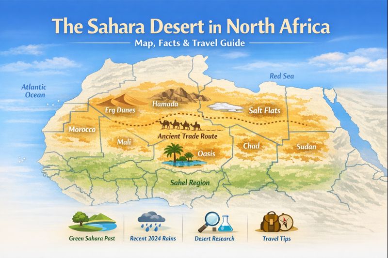
Whenever one mentions the term desert, he/she immediately imaginethe Sahara desert, which is a large and diverse desert in North Africa. It is also covered by rocky plateaus, stony plains, salt lakes and life oases in the sweeping dunes. This brief pillar PR includes definite facts, an easy description of the ancient Green Sahara, practical travel ideas, and a recent news hook (the 2024 rains that replenished Lake Iriqui) – written in simple English and understandable to students, travellers, and editors.
Quick facts — at a glance
- Area: Approximately 9 million km 2 (estimates are changing; desert boundaries move with time)
- East-west length: ~4,800 km ([?]3,000 miles)
- Primary nations: Algeria, Libya, Egypt, Sudan, Mauritania, Mali, Niger, Chad, Morocco (with Western Sahara), Tunisia and portions of others.
- Climate boundary (always a rough guide): A low rainfall of less than 250mm/yr usually indicates hyper-arid deserts.
- Not necessarily a desert: The Sahara was greener and had lakes, rivers and grasslands during the time of the African Humid Period.
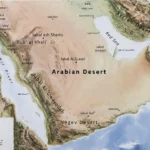
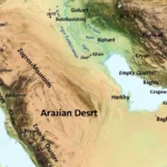
Where is the Sahara? Map and the countries it covers
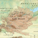
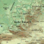
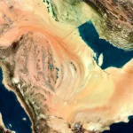
Sahara is on the North African continent, where it is bordered by the Atlantic on the east and the Red Sea to the west. It’s North borders the Mediterranean and the Atlas Mountains; its south border borders the Sahel, a semi-arid strip that crosses the continent. There is a slightly different definition of the precise boundary of the Sahara in some of the map systems, hence a neat SVG/vector map with overlays (country boundaries, large dunes, plateaus of hamada, chotts, major oases, and caravan routes) would be of great value to readers, travellers and planners.
How we define the Sahara
There’s no single rule for drawing the Sahara’s edge — multiple disciplines use different criteria:
- Climatology: rainfall thresholds (e.g., mean annual rainfall under ~250 mm) and evaporation rates are primary metrics.
- Ecology: vegetation cover, soil type and plant productivity help define desert vs. semi-arid margins.
- Geomorphology: landforms (ergs, hamadas, regs, chotts) reveal where wind and erosion have sculpted the surface into typical desert features.
- Human geography: settlement patterns, water access and historic land use also shape practical definitions.
Treating the Sahara as a mosaic — hyper-arid cores, semi-arid fringe zones that green up episodically, rocky plateaus and dune seas — produces more useful outcomes for conservation, travel and scientific study than a single hard line.
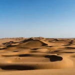
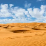
Landscape types — dunes, plateaus, salt flats & oases
The Sahara hosts several clearly distinct landscapes. Each has its own hazards, attractions and research importance.
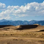
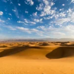
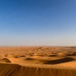
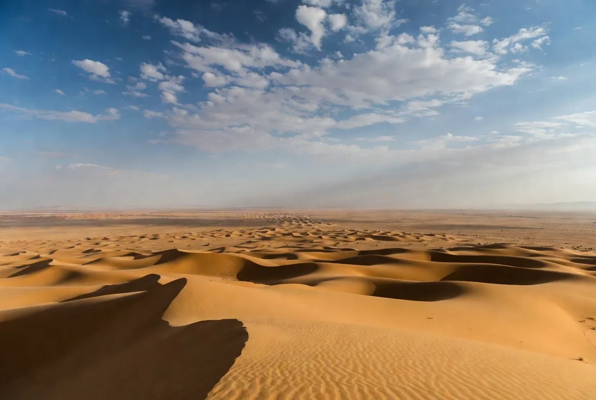
Ergs
- What they are: Broad fields of mobile sand with dunes that shift over time.
- Examples: Grand Erg Oriental, Erg Chebbi (Morocco).
- Notes for travellers: iconic scenery; deep sand needs experienced guides or specialised vehicles.
Hamada
- What they are: Flat or gently sloping bedrock and boulder-strewn plateaus.
- Why they matter: they often preserve archaeology and are usually easier for overland travel than soft sand.
Regs
- What they are: Hard surfaces of gravel and stones — frequently used as overland routes.
- Notes: fairly stable under vehicles, but can be deceptive underfoot.
Chotts and salt flats
- What they are: Low, flat depressions that accumulate salts and can fill as shallow, temporary lakes after heavy rain.
- Notes: can be impassable after wet events and may reflect sunlight strongly for photography.
Oases & wadis
- What they are: Where groundwater reaches the surface or where ephemeral streams flow after storms.
- Why they matter: these pockets of moisture support date palms, small agriculture and many settled communities.
Landscape types — quick comparison table
| Landscape | Typical features | Best time to visit | Notes |
| Erg (sand sea) | High dunes, shifting sand | Oct–Apr | Iconic, needs dune-driving skills |
| Hamada (rocky plateau) | Bedrock, boulders | Year-round | Stable, good for archaeology |
| Reg (gravel plain) | Firm surface | Year-round | Common travel corridors |
| Oasis | Date palms, irrigated fields | Spring/Autumn | Local farming depends on groundwater |
| Chott / playa | Salt flats, seasonal lakes | After rains | May be impassable after floods |
Climate and weather extremes
The Sahara mostly lies beneath the subtropical high-pressure belt, which produces generally sinking, dry air and little cloud. Combined with low humidity and intense solar heating, this creates large diurnal temperature swings: very hot by day and much cooler at night.
- Temperature: interior basins commonly exceed 45°C in summer; nights can drop sharply under clear skies.
- Rain: typically rare and spatially uneven. When strong convective storms or extratropical systems arrive, they can produce concentrated downpours and flash floods that rearrange channels, deposit sediment, and Sometimes rapidly fill ancient lakebeds. In 2024, exceptional rainfall in parts of southern Morocco produced dramatic floods and refilled Lake Iriqui, a dry lakebed captured in satellite images and media reports.
Climatic drivers — simple explanations
- Subtropical ridge: persistent high pressure causes air to subside and dry out.
- Monsoon shifts & teleconnections: variability in the West African Monsoon and sea-surface temperatures influence rainfall reach into the Sahara margins.
- Topography: mountains such as the Atlas focus orographic rains seaward of their slopes and can influence storm tracks.
Why variability matters: infrequent but intense rainfall events can recharge groundwater and create temporary wetlands, but they can also cause deadly floods and infrastructure damage — a double-edged sword for communities.
The Green Sahara — a short history
The Sahara was not necessarily dry. The African Humid Period (c. between 14,000 and c.5,000-4,500 years ago, in much of the area) involved strengthening of the monsoons and brought moist air further north; it converted most of the modern desert into grasslands, lakes and river basins. They fished, reared herds, painted rock art and left archaeological records, all over the land – scenes, some of hippos, giraffes and human action, where bone-dryness has now superficialised. This green past is well recorded in archaeology and paleoenvironmental studies.
With the oscillations of orbits, patterns of the ocean, and atmospheric feedback in changing places, the monsoon became weaker, wetlands shrank, some populations shifted southward to the Sahel, and others had to become more mobile or more trade-oriented. It is the historical climatic and human history that is mirrored in the current mosaic of dunes, mountains and isolated oases.
People & cultures
The Sahara is inhabited by a range of peoples whose cultures are rooted in long adaptation to dryness, mobility and resource management.
- Tuareg and Berber groups — nomadic or semi-nomadic across the central and western Sahara; known for distinctive textiles, silverwork and language variants.
- Bedouin — pastoral peoples historically present in the eastern Sahara margins.
- Sahrawi — communities of Western Sahara and adjacent regions with deep cultural ties to the land.
- Oasis communities — settled villagers who manage groundwater for date palms, small-scale crops and local markets.
Flora & fauna — survival in an extreme place
Life in the Sahara concentrates where water and shade exist:
- Plants: date palms dominate oases; drought-tolerant shrubs, succulents and ephemeral grasses appear after rains.
- Animals: small mammals and reptiles like the fennec fox and desert-adapted lizards are widespread in suitable habitats; large ungulates such as the addax are rare and highly threatened. Migratory birds also use the Sahara and Sahel as seasonal corridors.
- Conservation challenges: remoteness, limited funding and dispersed populations make wildlife monitoring and protection difficult. Oases are critical refuges both for human livelihoods and biodiversity.
How scientists study the Sahara
Modern Sahara research blends remote sensing, fieldwork and lab methods:
- Satellites map vegetation change, dune migration, floodwater extent and dust plumes. NASA and other satellite missions provided visible evidence of the 2024 flood events.
- Ground-penetrating radar reveals internal dune layering and structure.
- Luminescence dating (optically stimulated luminescence) dates when sand grains were last exposed to sunlight — crucial for reconstructing dune and lake histories.
- Archaeogenetics traces human population movements and social networks across wet and dry phases.
- Hydrogeology blends isotopic tracing and groundwater models to understand recharge and aquifer vulnerability.
Example finding: a recent study used ground-penetrating radar and luminescence dating on a star dune in eastern Morocco to show rapid growth and movement of these structures, overturning some older assumptions about dune timescales.
Recent news hook — 2024 rains and Lake Iriqui
In 2024, Morocco experienced extraordinary storms in the southern part and the neighbouring areas. The same events resulted in torrential, localised precipitation that resulted in flash floods and swamped expanses of desert that had not been wet in decades. Another case that shocked both residents and scientists was an ancient lakebed, Lake Iriqui, appearing again as satellite camera footage revealed that there was a lot of water covering the area between Zagora and Tata. These episodes demonstrate the effect of sudden, drastic events which can immediately rework the desert landscapes: the formation of temporary wetlands, the reworking of groundwater recharge processes, and the reconstruction of human risk.
Why is it important? Future climate regimes could have a larger number of more intense but not more frequent precipitation events. Societies and planners thus must have disaster preparedness for floods and long-term plans of groundwater management, infrastructure resilience and ecosystem stewardship.
.
Travel guide — when to go, where to go, safety and packing
Best seasons: Spring (March–May) and autumn (September–November) generally offer milder daytime temperatures. Winters can be pleasant by day but very cold at night; summer is extremely hot in the interior and not recommended for inexperienced travellers.
Top destinations & why:
- Morocco (Merzouga / Erg Chebbi & Zagora): accessible, strong local guiding infrastructure and tourist services.
- Tunisia (Douz): a classic gateway with cultural festivals.
- Algeria (Hoggar, Tassili n’Ajjer): spectacular rock art and plateaus — but travel often requires permits and planning.
- Egypt (Siwa Oasis, Western Desert): unique oasis culture and archaeology.
- Chad & Sudan margins: extremely remote and adventurous; proceed only with careful local advice and security checks.
Safety tips
- Travel with reputable local guides familiar with routes and water sources.
- Carry sufficient water, sun protection and a means of emergency communication (satellite messenger if remote).
- For self-driving, carry recovery gear, know sand-driving techniques (deflating tyres on soft sand, avoiding sudden turns) and always tell someone your itinerary.
- Respect local customs and secure permits where required. Check travel advisories for political/security concerns.
Packing checklist
| Item | Why it matters |
| Water bottles + purification tablets | Avoid dehydration |
| High-SPF sunscreen, wide hat, sunglasses | Sun protection |
| Lightweight layers + warm jacket | Cold nights |
| Sturdy boots + gaiters | Walking in sand/rock |
| Satellite communicator or local SIM | Safety in remote areas |
| Vehicle recovery kit (if self-driving) | Avoid being stranded |
| Local-currency cash & permits | Limited ATM access in remote towns |
Practical tips for desert driving & vehicles
- Use a well-maintained 4×4 with spare tyres, jack, shovel, traction mats and tow straps.
- Sand-driving basics: reduce tyre pressures when on soft dunes, maintain momentum up dunes, and steer smoothly to avoid digging in.
- For long routes, plan fuel and water caches, and always file a travel plan with a local contact.
Threats & planning — climate change, land use, flooding
Most climate impacts appear first at margins — oases, Sahel-edge communities and irrigated farmland.
Key threats:
- Changing rainfall patterns: models and observations point to more variable rainfall with potential for intense storms that cause both drought and floods. The 2024 rains illustrate the destructive and rejuvenating potential of such events.
- Desertification & land misuse: overgrazing and unsustainable irrigation reduce soil resilience and increase erosion.
- Sand encroachment: moving dunes can bury roads and infrastructure.
- Conservation gaps: remote regions are hard to monitor and protect, and many species lack robust population data.
Adaptation priorities:
- Protect groundwater recharge zones and invest in flood-resilient infrastructure.
- Combine local knowledge with modern hydrological science for community land stewardship.
- Support monitoring systems (satellites + community observations) to detect dune movement, vegetation recovery and flood risk.
How the Sahara connects to global systems
- Dust export: Saharan dust lifts into the atmosphere and travels across continents — fertilising soils in places like the Amazon, affecting air quality and influencing weather systems and hurricane formation.
- Climate records: lake sediments, dune stratigraphy and paleosoils are archives of past climates that help scientists understand Earth’s climate history and predict future changes.
Interesting facts
- Star dunes are pyramid-shaped dunes with radiating arms; recent research shows some formed faster than previously believed.
- Lake Iriqui refilled after exceptional rains in 2024, creating short-lived wetlands visible from space.
- The Sahara influences distant regions by exporting dust that can fertilise tropical forests and modify atmospheric chemistry.
FAQs
A: The Sahara is a stretch of land that extends through northern Africa between the Atlantic and Red seas, crossing big portions of Algeria, Libya, Egypt, Mauritania, Mali, Niger, Chad, Sudan, Morocco (and Western Sahara) and Tunisia.
A: Approximately 9-9.2 million km2 (depending on the definition), and the largest hot desert on earth.
A: Yes. The Sahara had lakes, rivers and grasslands during the African Humid Period, and archaeological evidence, as well as paleoenvironmental data, indicates lakeside communities and animals presently found in wetter areas.
A: Occasionally, but severe consequences of rainfall may lead to flash floods and the temporary refilling of old lakebeds – e.g., in 2024, heavy rains sent Lake Iriqui in Morocco.
A: A lot of places are welcoming to visitors with the right preparation and guides around the area; a travel warning should always be observed, the local culture should be observed, and adverse weather conditions should be anticipated, such as heat or cold nights, and remote areas.
Conclusion
Sahara is not simply a desert of sand, but a geological, living, dynamic and strong history and resilient cultures. Isolated phenomena such as the 2024 rains to replenish Lake Iriqui demonstrate that deserts can transform rapidly, and planning and local knowledge are important. Consult the maps, travel tips and websites in this guide to explore sustainably and keep up with new studies and weather conditions.