Introduction
The Taklamakan Desert is one of China’s most important and striking landscapes. Located in Xinjiang’s Tarim Basin, it is surrounded by mountain ranges, oasis towns, ancient Silk Road routes, and modern transport corridors. This guide explains its location, boundaries, climate, routes, and travel context in a clear map-focused way.
Quick Facts About the Taklamakan Desert
| Topic | Key detail | Why it matters |
| Location | Central Tarim Basin, Xinjiang, northwest China | Shows why the desert is enclosed by mountain systems |
| Size | About 320,000 square kilometers | Explains the desert’s massive footprint |
| Shape | Roughly 960 km east to west and around 420 km wide | Helps readers visualize its scale |
| Climate | Continental desert climate, very dry, extreme temperature shifts | Explains the harsh travel and living conditions |
| Landscape | Shifting dunes, salt flats, gravel plains, river-fed margins | Shows that the desert is more varied than “just sand.” |
| Transport | Rail loop, desert highway, rim-city road connections | Makes the region easier to understand today |
| ConservationA | A 3,000-km green belt was completed around the desert in 2024 | Important for sand control and land stabilization |
| Best travel window | Late October to mid-November | Useful for itinerary planning |
Where the Taklamakan Desert Is on a China Map
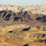
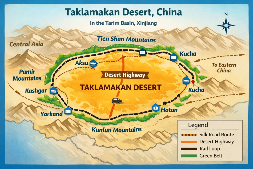
The Taklamakan Desert is located in northwest China, within the Xinjiang Uyghur Autonomous Region, and occupies the central zone of the Tarim Basin. This basin is a huge inland depression, and the desert sits at its center like a dry core inside a mountain ring. The northern boundary is formed by the Tien Shan, the western boundary opens toward the Pamir Mountains, the southern edge is framed by the Kunlun Mountains, and the broader basin transition toward other arid zones influences the eastern side.
That geographic setup is essential to understanding the desert. On a basic map, the Taklamakan may appear as a large pale shape in western China. But a more useful map view shows the full spatial system around it: mountains, river-fed oases, historic settlements, transport arteries, and the interior sand mass itself. The desert is not isolated in the sense of being disconnected. It is isolated in the sense that natural moisture is Blocked from reaching it.
A strong map-reading strategy is to see the Taklamakan as a contained desert system rather than an empty void. The desert’s position inside the Tarim Basin explains nearly everything else about it: the dryness, the dune mobility, the sparse vegetation, the historic caravan routes, and the location of the human settlements around the edge.
1.1 The Tarim Basin as the Geographic Frame
The Tarim Basin is the larger geographic container that gives the Taklamakan its identity. Because the basin is enclosed by high mountains, moist air masses are largely prevented from entering the interior. That means precipitation remains low, evaporation remains intense, and the environment stays extremely dry through most of the year.
This basin structure is a major semantic anchor for readers because it explains the desert’s formation, its ecological limits, and the way people have lived around it for centuries. In geographic terms, the Tarim Basin is the frame, and the Taklamakan is the central arid body inside that frame.
1.2 Why the Location Matters
The desert’s position matters for several reasons:
- It shapes where water can exist.
- It determines where towns can survive.
- It influences historic movement patterns.
- It affects modern rail and road engineering.
- It explains why the region is so important for climate, ecology, and trade.
For map-based content, this is the core message: the Taklamakan cannot be understood as a standalone desert. It must be read in relation to the basin, the mountains, and the oasis ring.
What Surrounds the Taklamakan Desert
The Taklamakan is bordered by some of the most important physical and human features in western China. On the outside are mountain chains; on the inside edge are the oases and settlement corridors that have supported life for centuries. The surrounding system is what gives the desert its historical and geographic meaning.
The major surrounding features include:
- Tien Shan to the north
- Kunlun Mountains to the south
- Pamir Mountains to the west
- The broader eastward basin transition in Xinjiang
- Oasis cities such as Kashgar, Hotan, Aksu, Kucha, and Yarkand
These names are not just place labels. The are structural nodes in the human geography of the region. They mark the edge of habitability. Ther mark trade pathways. They mark the points where rivers, groundwater, and agriculture make settlement possible.
A simple way to think about the Taklamakan is this: the center is the hardest zone, the rim is the livable zone, and the mountains are the moisture barrier.
Taklamakan Desert Boundaries Explained
Any article about the Taklamakan Desert map needs boundary clarity. Readers want to know where the desert begins and ends, and what lands lie just beyond it. The boundary logic is important not only for geography but also for route planning, conservation analysis, and historical interpretation.
3.1 Northern Boundary
The northern edge of the Taklamakan touches the southern foothills of the Tien Shan. This is where a chain of oasis settlements has traditionally existed because river water and groundwater allow agriculture and local life. Cities and towns such as Aksu and Kucha belong to this northern rim zone.
From a map perspective, the northern boundary is one of the clearest examples of a desert edge shaped by water access. The terrain becomes more livable where meltwater-fed rivers and alluvial fans reach the basin margin.
3.2 Southern Boundary
The southern boundary meets the Kunlun Mountains. This side of the desert is associated with the southern oasis belt, where Hotan and related settlements have long played a role in agriculture, trade, and regional movement. The mountains here act like a barrier wall, while the oasis strip functions like a narrow habitable corridor.
This southern edge is especially important in Silk Road geography because it supported the southern route around the desert.
3.3 Western Boundary
The western side opens toward the Pamir region and the broader western Tarim Basin area. This side is historically connected to the routes linking western China with Central Asia. Kashgar is the most famous western gateway city in this system. It sits at a strategic point where oasis life, trade, and long-distance movement meet.
For map readers, the western boundary is not just a border line. It is a gateway zone, where geography becomes commerce and commerce becomes culture.
3.4 Eastern Boundary
The eastern side of the Taklamakan is more open in basin terms, but it is still extremely arid and harsh. It is one of the zones where dust activity can become intense and where the desert’s influence spreads outward. Modern satellite imagery has repeatedly shown how dust from the eastern Taklamakan can expand across the basin and beyond.
That eastern openness matters because it helps explain how dust migrates, how land degradation is monitored, and how the desert interacts with the wider atmosphere.
Climate and Weather: Why the Taklamakan Feels So Severe
The Taklamakan Desert has a continental desert climate. That means low rainfall, strong evaporation, large day-night temperature shifts, and major seasonal contrast. The climate is one of the most important reasons the desert is so difficult to cross and so hard to cultivate.
The key climate features are:
- Very low annual precipitation
- High evaporation
- Intense summer heat
- Cold winter conditions
- Large diurnal temperature range
- Frequent dust storm activity
This is not a static environment. It is an active one. Wind moves sediment. Dust rises into the air. Temperatures swing sharply. Seasonal discomfort is not a side issue here; it is part of the core climate identity of the desert.
4.1 Temperature Extremes
The Taklamakan’s temperature pattern is sharply continental. Summers can become very hot, while winters can become bitterly cold. The annual range is large enough to affect settlement design, transport scheduling, agricultural timing, and travel planning.
For travelers and researchers, this means one thing: season matters. The same route can feel manageable in one month and punishing in another. That is why desert travel should be evaluated by climate window, not by map distance alone.
4.2 Rainfall and Dryness
Rainfall across the Taklamakan is extremely limited. In some areas, annual precipitation is so low that the environment remains overwhelmingly arid for long stretches of the year. Evaporation far exceeds rainfall, which means water scarcity is a permanent geographic constraint.
This dryness is the reason the desert’s interior supports so little plant growth. It is also the reason oases exist only where groundwater, river flow, or human-managed water systems make life possible.
4.3 Dust and Wind Activity
Dust storms are one of the defining atmospheric features of the Taklamakan. Strong winds can lift fine material from the desert surface and push it into the wider region. That makes the Taklamakan one of the major dust source zones in Asia.
For a map-focused article, this is a crucial semantic layer. The desert is not only a ground surface; it is also a climate system. The air above it is part of the story.
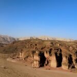
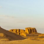
Landscape Structure: Sand, Gravel, Salt, and Oasis Edges
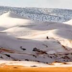
A common misconception is that the Taklamakan is a single, uninterrupted field of soft sand. In reality, its landscape is more complex and more textured. It includes shifting sand dune zones, gravelly and pebbled lowlands, salt marsh depressions, river-fed margins, and oasis pockets.
That complexity is important because it changes how readers understand the region. A more accurate mental map includes landform diversity, not just a dune stereotype.
5.1 Mobile Sand Dunes
A major share of the Taklamakan is made up of mobile dunes. These dunes are constantly shaped by wind and are not fixed in place. That mobility creates hazards for roads, settlements, and long-distance travel.
The dune system is one reason the desert has such a strong reputation. It is not a stable surface that behaves predictably. It is a shifting terrain that changes under atmospheric pressure and seasonal wind patterns.
5.2 Gravel and Pebble Plains
Not every part of the Taklamakan is dune-covered. Some areas are covered by gravel or pebbly ground, which gives the desert a more varied internal structure. These zones may be less visually dramatic than giant dunes, but they are still important in the broader landform mosaic.
They also matter for route alignment because not all desert terrain is equally difficult. Different surfaces require different engineering responses.
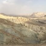
5.3 Salt Marshes and Depressions
Salt-bearing depressions occur in parts of the desert where water accumulates and then evaporates, leaving mineral residues behind. These areas are ecologically harsh and visually distinct, and they contribute to the desert’s mixed character.
5.4 River Margins and Oases
The most important life-supporting zones are the river margins and oases. Here, groundwater and meltwater-fed channels allow settlement, agriculture, and transport. This is where human geography and physical geography converge.
If the interior is the desert core, the margins are the survival belt.
Flora: What Can Grow in the Taklamakan?
Vegetation in the Taklamakan is sparse, limited, and highly dependent on moisture availability. In the driest areas, plant cover is virtually absent. But in places where groundwater comes close to the surface or where irrigation and river systems support growth, life can take hold.
Typical plants associated with the desert’s limited vegetation include:
- Tamarisk
- Nitre bushes
- Reeds
- Poplar-based woodland in some basin-edge areas
- Other drought-tolerant shrubs and riparian plants
This sparse ecology matters for map interpretation. Vegetation is a clue. It signals where water exists, where land use is possible, and where protective green barriers may be present. In a desert region, plant cover is not just biological information. It is spatial information.
Vegetation often marks the threshold between barren core and livable edge. For that reason, plant distribution should be treated as a geographic signal, not just an ecological note.
Fauna: Which Animals Live Here?
Animal life in the Taklamakan is limited but not absent. Species survival depends heavily on the availability of water, shelter, and edge habitats. The center of the desert is too harsh for most wildlife, but the river valleys, oasis strips, and margins support more biodiversity.
Animals associated with the broader Taklamakan and Tarim Basin environment include:
- Rare deer species in river-fed areas
- Wild camels in parts of the desert ecosystem
- Other desert-adapted or riparian species that survive near water corridors
The key point is that wildlife distribution in the Taklamakan follows the same logic as human settlement: the edges are livable, the center is extreme. That is a recurring geographic pattern worth highlighting in any article or map guide.
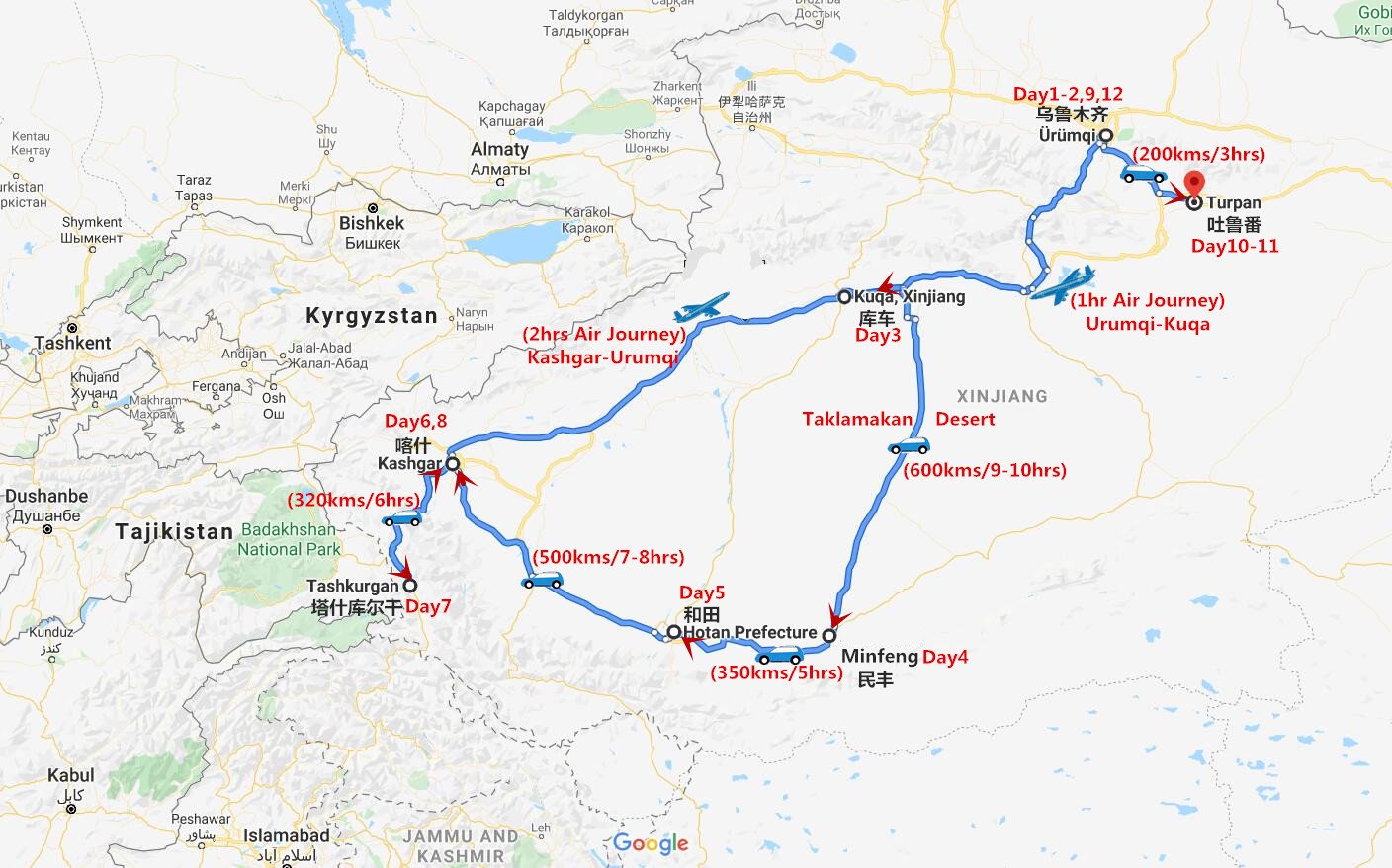
Silk Road Routes and Historic Travel Around the Taklamakan
The Taklamakan has deep historical significance because it sat beside one of the most famous trade systems in world history: the Silk Road. People usually did not attempt to cross the center of the desert. Instead, they moved around its rim, using oasis towns as resting points, trade nodes, and supply stations.
This is one of the most important interpretive layers for readers. The Taklamakan is not just a physical desert; it is a historical corridor of avoidance and adaptation. Travelers moved where water existed, not where the sand was most direct.
8.1 Northern Silk Road Corridor
The northern route ran along the base of the Tien Shan. It used oasis towns such as Aksu and Kucha as important stops. These places supported trade because they had access to rivers and agricultural land. They were logistical anchors in a hostile landscape.
8.2 Southern Silk Road Corridor
The southern route followed the oasis chain near the Kunlun Mountains and linked places such as Hotan and Yarkand. This corridor was just as significant as the northern one because it offered a navigable path around the desert’s southern edge.
8.3 Why the Desert Interior Was Avoided
The interior was avoided for simple but powerful reasons:
- Too dry
- Too unstable
- Too dangerous
- Too difficult to provision
- Too likely to exhaust travelers and animals
In premodern trade, risk management was everything. The rim routes offered lower risk, access to food and water, and a chain of settlements that could sustain long-distance movement.
The Silk Road story of the Taklamakan is therefore a story of edge geography. Civilization clustered where survival was possible.
Modern Transport Links: Roads, Rail, and Access
The modern Taklamakan is no longer the same kind of barrier that it once was. Roads, railways, and engineered desert corridors have changed how people move around and through the basin. The area remains harsh, but it is more connected than before.
This matters for anyone building a map-focused content piece because transport is part of the desert’s current identity. The modern Taklamakan is both a natural landscape and a managed corridor.
9.1 The Tarim Desert Highway
The Tarim Desert Highway is one of the most famous modern access routes in the region. It crosses the Taklamakan and is widely recognized as a major desert road. Because it runs through an environment where sand movement is constant, the highway has long required protective shelterbelts and other engineering measures.
This highway is significant because it demonstrates how infrastructure can be adapted to extreme conditions. It is a physical link across a hostile terrain, and it symbolizes the practical modernization of the region.
9.2 The Desert Loop Railway
A major recent transport milestone is the desert loop railway around the Taklamakan. This rail network connects several major cities along the basin’s rim and helps integrate the region more efficiently. The loop is important not only for passenger movement but also for logistics, regional development, and spatial connectivity.
For map readers, the rail loop transforms the desert from a blank center into a ringed system with active circulation.
9.3 Why Roads and Rail Matter in a Desert Article
Transport is not a side note. It changes the reader’s mental model of the region.
- It shows where movement is practical.
- It reveals how engineering responds to sand.
- It connects history to the present.
- It demonstrates how the desert is managed rather than simply endured.
10. Travel Notes: How to Plan a Taklamakan Visit
A visit to the Taklamakan is not casual tourism in the ordinary sense. It requires planning, climate awareness, route discipline, and respect for the terrain. This is a region where the best travel experiences are usually tied to the rim cities, the engineered corridors, and the seasonal window when conditions are more manageable.
10.1 Best Time to Visit
The most comfortable travel period is usually the shoulder season, with late October to mid-November often recommended for the desert itself. During this time, temperatures are more moderate, dust activity is often less severe than in peak windy periods, and the landscape may be more pleasant to observe.
10.2 Travel Mindset
A successful trip to the Taklamakan should be planned around terrain logic, not romantic impulse. The key idea is this: do not treat the desert as a casual off-road playground. Treat it as a serious landscape that rewards preparation and punishes neglect.
10.3 Safety Checklist
A practical desert-edge checklist includes:
- Carry more water than you think you will need.
- Use reliable local transport or guided routes.
- Monitor dust and wind conditions.
- Avoid unplanned movement into interior dune zones.
- Prioritize oasis towns and established transport corridors.
- Respect seasonal temperature swings.
Conservation and the Green Belt Around the Desert
Desert conservation has become a major contemporary theme in the Taklamakan. In recent years, China has completed a long green belt around the desert to help stabilize sand movement and reduce the impact of drifting dunes on roads, farms, and settlements.
This effort is important because the Taklamakan is not only a natural feature. It is also a managed landscape. Human activity around the desert depends on controlling sand, protecting infrastructure, and supporting oasis life.
The green belt represents an intersection of ecology, engineering, and land policy. It is a reminder that the desert boundary is not fixed. It is actively maintained and negotiated.
For readers, this adds modern relevance. The story is not only about ancient Silk Road routes or dramatic dunes. It is also about climate adaptation, environmental management, and regional resilience.
Why the Taklamakan Desert Matters Today
The Taklamakan matters for several overlapping reasons:
- Geographic importance
It is one of China’s most significant desert systems and a major feature of the Xinjiang landscape. - Historical importance
It shaped the movement of the Silk Road trade and helped define the oasis city network. - Environmental importance
It is part of a fragile arid ecosystem affected by wind, dust, and water scarcity. - Infrastructure importance
It now includes major transport and engineering projects that change regional access. - Content relevance
It satisfies strong search intent around map location, boundaries, climate, routes, and travel planning.
That combination makes it a powerful pillar topic. A reader rarely comes to the Taklamakan page with only one question. They usually want a full geographic explanation. That is why the best content must combine map, climate, history, transport, and planning into one searchable framework.
What a Good Taklamakan Desert China Map Should Show
If the goal is to create a map-centered page that performs well for both users and search engines, the map itself should communicate the region’s full spatial logic. A strong map should include:
- The Tarim Basin outline
- The surrounding mountain systems:
- Tien Shan
- Kunlun Mountains
- Pamir Mountains
- The main oasis towns:
- Kashgar
- Hotan
- Aksu
- Kucha
- Yarkand
- The Silk Road rim routes
- The Tarim Desert Highway
- The rail loop corridor
- The green belt/shelterbelt zones
- The major river-fed settlement edges
A map that includes these elements does more than locate the desert. It explains how the desert works.
FAQs
It is in northwest China, inside the Tarim Basin of Xinjiang, surrounded by major mountain ranges.
Britannica gives it an area of about 320,000 square kilometers. Other sources use slightly different figures, but they all show that it is one of the world’s largest sandy deserts.
It is famous for its huge dune fields, very dry climate, Silk Road history, and modern desert-control projects.
Many travel sources recommend late October to mid-November because the weather is more comfortable and dust storms are lower.
It should show the Tarim Basin, the mountain borders, the oasis towns, the Silk Road edge routes, the rail loop, the Tarim Desert Highway, and the green belt around the desert.
Conclusion
The Taklamakan Desert is far more than a sandy region on a map. It is a vast geographic system shaped by mountains, climate, oasis life, Silk Road history, and modern infrastructure. Understanding its map reveals how geography, travel, and human settlement all connect across northwest China.