Introduction
The fact that the Sahara Desert was flooded is at the border of science, history, and faith. Geologists have found out that huge sections of the current desert were originally green, which could sustain lakes, rivers, wildlife, as well as human settlements. Simultaneously, other readers question the fact whether this evidence helps to prove the biblical narration of the Noah Flood. This paper presents these two views as opposites and narrates what science really tells us, what the Bible tells us, and where there are similarities, or obvious differences, between the two positions, using clear timelines, evidence, and plain language.
What the Bible says about a great flood
Genesis timeline & key verses
The Genesis flood narrative (chapters 6–9) presents a compact story with these canonical beats:
- Divine judgment is announced because human violence is great.
- Noah builds an ark; his family and selected animals are saved.
- Rain falls “forty days and forty nights.”
- Waters prevail and “cover the earth”; later, the waters recede, and the ark rests on the mountains of Ararat.
- Noah sends birds to find land; eventually,y a covenant is made (rainbow).
Different faith traditions and translations vary in minor details, but the core chronology in the Hebrew text centers on a short, intense flood period (rains for 40 days, waters rising and subsiding across months). The narrative frames the event as divine and world-altering. Many readers interpret these verses literally, while others read them as regional, symbolic, or theological. Because the story claims a short, high-impact inundation, it creates a strong expectation that the geological record should show a single, synchronous, global sedimentary signature if the event were literal and worldwide.
Biblical interpretive traditions
There are three broad interpretive approaches commonly encountered:
- Literal-global: the flood was a unique, supernatural event that inundated all (or almost all) the earth’s land surface. This view expects a synchronous global geological signal.
- Regional/large-local: an extraordinary regional inundation (for example, a catastrophic river or sea incursion) was later narrated as a global event in oral tradition; the core memory may reflect a dramatic but localized disaster.
- Literary/theological: the story communicates theological truths about judgment, deliverance, and covenant; it is not read as a literal, technical chronicle of planetary hydrology.
Why the Sahara was wet: the science
What science says
Reconstructing past environments combines independent methods — each called a proxy — which together create a robust picture. The main tools are:
- Sediment cores from lakebeds and wetlands (layered deposits record wet/dry cycles).
- Radiocarbon and other chronology methods (age control for organic layers and shells).
- Fossils of freshwater animals (hippos, crocodiles, freshwater snails) are far from modern rivers.
- Pollen and plant macrofossils (which indicate what vegetation grew and when).
- Rock art and archaeology (human depictions and occupation layers that align with wetter conditions).
- Paleoclimate models (simulate how orbital changes and feedbacks alter monsoon strength).
Taken together, these proxies indicate repeated periods when North Africa was far wetter. The best-known interval in the recent geologic past is the African Humid Period (AHP), when monsoonal rains pushed far north and produced lakes, rivers, and savanna-like vegetation across regions now hyper-arid. Climate-model experiments and a growing synthesis of geological records show that these intervals are paced by changes in Earth’s orbit and are amplified or modulated by feedbacks involving vegetation, soil, and dust.
Timeline: when the Sahara was green
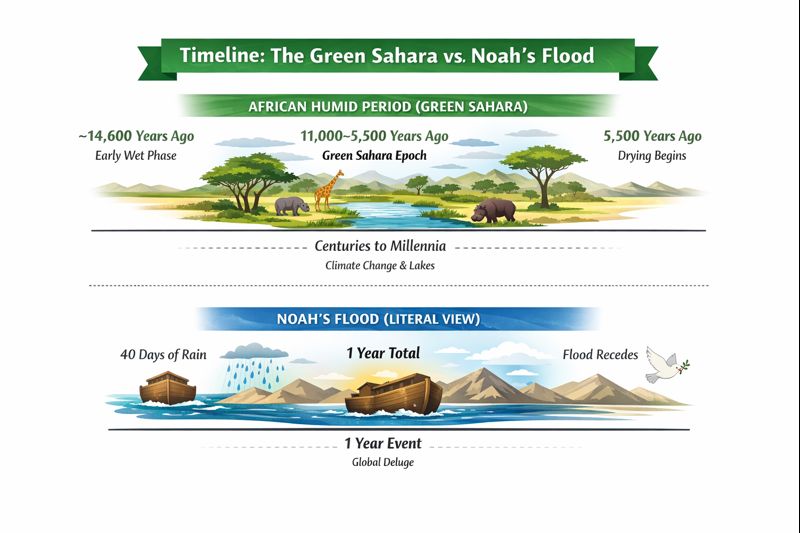
Dating is a core part of the scientific story. While exact boundaries differ by locality, a simple topline chronology is:
- ~14,600 years ago: Some regions show early wetting after the last glacial maximum.
- ~11,000–~5,500 years before present (BP): The main Holocene humid phase — commonly referred to as the Green Sahara or African Humid Period. This is when many lakes and rivers were at their largest Holocene extents.
- ~5,500 years ago onward: Progressive drying in much of the region, with some basins becoming arid sooner and others later. The termination sometimes appears abrupt in particular cores — pointing to local threshold behavior — but across the continent, the shift spans centuries to millennia.
Note: “Before present” (BP) is a standard dating notation where “present” is 1950 CE for radiocarbon chronology. Regional variations exist: some basins retain water into later millennia; others desiccated earlier.
Key scientific evidence: sediments, fossils, rock art
Sediment cores & paleolake deposits
Where lakes once existed, we now find Stratified deposits: alternating layers of organic-rich sediment, diatom-bearing silts, shore gravel,s and carbonate tufa or travertine. These layered sequences show repeated years of accumulation and, when dated, often indicate decades-to-millennia of lacustrine (lake) conditions — not a single catastrophic deposit. Radiocarbon ages from organic layers and shells in these cores provide the chronology that ties lakes to the Holocene humid window. High-resolution cores reveal seasonal deposits and diatom assemblages diagnostic of freshwater versus saline conditions.
Fossil animals
Fossilized remains of hippopotamus, crocodile, freshwater fish, and waterfowl occur many hundreds of kilometers from today’s permanent rivers. These animals require sustained water and vegetated corridors, so their presence indicates long-standing wet habitats. Hippo remains alone are powerful evidence: hippos need substantial and reliable water bodies and cannot persist in ephemeral crunch-year ponds for centuries. Their bones, sometimes found in lake-shore sediments, are dated to the mid-Holocene humid interval in many localities.
Rock art
Rock art panels (paintings and engravings) from sites such as Tassili n’Ajjer (Algeria) and the Ennedi Plateau (Chad) depict giraffes, elephants, cattle, boats, and fishing scenes. These portrayals are cultural eyewitness records: humans depicting the animals and activities they observed. Tassili n’Ajjer, a UNESCO World Heritage site, contains thousands of images that document changing environments and human lifeways across millennia. The iconography correlates with the sedimentary and fossil evidence that indicates wetter landscapes.
Pollen and plant remains.
Pollen trapped in lake and marsh sediments reveals what plants dominated at different times. During humid phases, pollen records show increased representation of savanna trees and grasses and freshwater wetland plants, consistent with expanded monsoonal rainfall.
Climate models
Numerical climate simulations reproduce much of the observed pattern: small changes in Earth’s orbit (precession) produced stronger summer insolation in the Northern Hemisphere, intensifying the African monsoon and allowing monsoon rains to penetrate northward. Although models vary in amplitude and detail, coupled climate-vegetation simulations broadly support an orbitally driven mechanism for the AHP, amplified by vegetation and albedo (reflectivity) feedbacks.
Where creationist authors link Sahara evidence to Noah’s Flood
Many faith-aligned websites and authors argue that features of the Sahara are best explained by a single, catastrophic flood consistent with a literal Noah narrative. Their core claims typically include:
- Catastrophic origin for sediments: They argue that lake and shoreline deposits could have been laid down rapidly by a single, enormous flood rather than by long-lived lakes.
- Spectacular landforms as flood erosion: Dramatic features such as the Richat Structure (“Eye of the Sahara”) are sometimes claimed to be megaflood scars or flood-related features.
- Questioning dating methods: Radiocarbon, OSL (optically stimulated luminescence), and other age methods are challenged as unreliable, biased, or systematically off by orders of magnitude — an argument used to fit geological observations into a young-earth chronology.
Reconciling (or not) the two views — timeline & scale comparison
This is the central issue: timescale and mechanism.
Timeline comparison
| Hypothesis | Typical timescale | Mechanism |
| Noah’s Flood (literalist) | ~1 year (40–150 days in narrative) | Catastrophic, often supernatural |
| African Humid Period (science) | Centuries to millennia (~14,600–~5,500 BP major phases) | Orbital forcing → monsoon shift → centuries of wetter climate. |
Main mismatch: the biblical literalist timeline describes a one-year cataclysm; the AHP is a long-term climatic state. The sedimentary and ecological signatures expected from each are different: a one-year, worldwide inundation should leave highly chaotic, synchronous deposits across distant basins; the AHP leaves layered lacustrine sequences, slow accumulations, and regionally variable timing.
Head-to-head: African Humid Period vs Noah’s Flood
| Feature | African Humid Period (AHP) | Noah’s Flood (literalist claim) |
| Duration | Centuries — millennia | ~1 year (40–150 days) |
| Mechanism | Orbital forcing; monsoon shift | Catastrophic, supernatural |
| Sedimentary signature | Layered lake sediments, diatoms, tufa | Expect chaotic, synchronous deposits |
| Archaeological record | Continuous occupation with gradual change | Expect abrupt, synchronous global cultural collapse |
| Geographic scope | Northern Africa and adjacent regions | Claimed global coverage |
| Fit with evidence | Strong multi-proxy fit | Poor match to broad scientific records |
This table makes the mismatch plain: AHP and the literal Flood narrative fit the empirical record in profoundly different ways.
Evidence types, what they show, and how they fit each hypothesis
| Evidence type | What it shows | Fits AHP? | Fits a one-year global Flood? |
| Paleolake cores & shorelines | Long-lived lakes, layered sediments | Yes | No — durations too long |
| Diatoms & microfossils | Aquatic conditions persisted | Yes | No |
| Radiocarbon chronologies | Ages of deposits and shells | Yes | Mostly No |
| Rock art | Human depiction of wetland life | Yes (cultural record) | Not direct evidence |
| Regional stratigraphy | Local erosion/deposition timing | Yes (heterogeneous) | Not consistent with global simultaneity |
Location, geography & notable sites
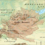
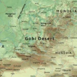
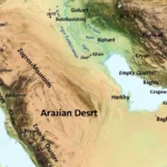
Where is the Sahara?
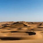
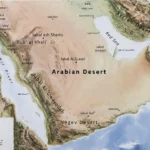
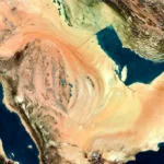
The Sahara spans most of North Africa: from the Atlantic coasts of Mauritania and Western Sahara in the west to the Red Sea in the east, and from the Mediterranean southward toward the Sahel. It is not a uniform plain: it contains plateaus, rocky massifs, basins, fossil river systems, and sand seas (ergs).
Key paleolandmarks & sites to mention
- Tassili n’Ajjer (Algeria): spectacular rock art panels that document fauna and human activity in past wetter times. The site is a UNESCO World Heritage property with thousands of depictions.
- Ennedi Plateau (Chad): rock formations and rock art recording now-absent wildlife.
- Paleo-Lake Chad: once far larger than today’s shallow remnant; its basin shows multiple highstands.
- Lake Megafezzan (Libya): a large palaeolake basin with marine-like shorelines and lacustrine deposits.
- Richat Structure (Mauritania): the “Eye of the Sahara” — a circular geologic dome interpreted by geologists as an eroded igneous and sedimentary structure rather than a flood scour. The mainstream geological interpretation is supported by stratigraphy and igneous petrology.
Climate and weather patterns that made the Green Sahara
How did the Sahara become green?
Small but sustained shifts in Earth’s orbital parameters (particularly precession) altered the seasonal distribution of solar heating. When Northern Hemisphere summer insolation increased, warmer land and ocean conditions strengthened the West African monsoon. This drove heavier summer rains farther north, supporting grassland and lake systems across areas now desert. Feedbacks involving vegetation cover and dust also modulated the system: vegetation reduces albedo (absorbs more sunlight), enhancing rainfall; dust can reduce sunlight and suppress monsoon strength. The combined effect allowed the Sahara to host mesic (moist) environments for long intervals. Climate models reproduce much of this behavior, though some uncertainties about amplitudes and feedbacks remain in detail.
Why did some areas dry suddenly?
Local threshold behavior is important. When vegetation cover declines past a tipping point, albedo increases, and the local monsoon response can collapse quickly, producing relatively abrupt desiccation recorded in some lake cores. These local rapid changes do not imply a single synchronous global flood — instead,d they reflect spatially variable thresholds in a complex climate system.
Flora and fauna during humid phases
Plants: Pollen sequences show expansion of savanna trees, grasses, papyrus, and wetland vegetation northward into the present desert. These changes are consistent with sustained monsoonal precipitation and standing water.
Animals: The fossil record and archaeological assemblages include hippos, crocodiles, elephants, giraffes, antelopes, and abundant fish species that require sustained, vegetated habitats. Their presence in now-arid terrains is one of the clearest signals that the environment was once wholly different.
Human life: Archaeology documents fishing, herding, and pastoral economies in parts of the Sahara. Rock shelters contain burials, toolkits, and art that show long-term occupation and cultural continuity through humid and drying phases.
Human history and cultures in the Green Sahara
Archaeological discoveries reveal rich cultural diversity during humid phases. Sites such as Takarkori in Libya have produced burials and cultural remains that reflect local adaptation to lakes and wetlands. Recent genetic and archaeological work suggests discrete populations with regionally distinct ancestries lived in the Green Sahara and later migrated or became assimilated as conditions changed. These human records show adaptation rather than instantaneous collapse; people moved, altered subsistence strategies, and in some cases maintained cultural continuity even as local ecologies shifted.
Landscape features: dunes, paleolakes, tufa, and the Richat Structure
Paleolakes and chotts: Former lake basins often preserve shoreline features, deltaic deposits,s and evaporite layers (salts) that indicate long-standing lakes or ephemeral episodes at different times.
Dunes: Dune systems are dynamic features produced by wind and sometimes stabilized by vegetation during wetter phases. Their stratigraphy can record alternating wet and dry conditions.
Tufa and travertine deposits: Freshwater carbonate deposits (tufa) indicate long-lived springs and lakes. They form slowly as carbonate precipitates around aquatic plants and along shorelines.
Richat Structure (Eye of the Sahara): A striking circular feature roughly 40 km across. Geological analyses interpret it as an eroded dome with concentric rings of varying lithology and ages — not as a megaflood crater. The structure’s stratigraphy and igneous intrusions explain its concentric morphology. Geological authorities catalog it as a dome and complex of intrusions and erosional forms.
Environmental issues and conservation
Rock art panels are fragile and face erosion, vandalism, sm and looting. Many paleolandscape sites are remote and vulnerable to tourism pressure if poorly managed. Conservation programs, sustainable tourism, and local stewardship are crucial for protecting both cultural and geological heritage. The scientific study of past abrupt climate shifts in the Sahara also benefits modern climate science: the termination of the AHP serves as a natural laboratory for understanding tipping points and feedbacks that are crucial for the future in a warming world.
Useful short glossary
- African Humid Period (AHP): A long interval during which north Africa supported lakes, rivers, and vegetation; often centered in the Holocene between ~11,000 and ~5,500 BP.
- Paleolake: An ancient lake no longer present.
- Radiocarbon dating: A technique to date organic material up to ~50,000 years old.
- Diatoms: Microscopic algae with silica shells that indicate aquatic conditions.
- Tufa: Calcium carbonate deposits formed in freshwater — evidence of springs or shoreline conditions.
FAQs
A: The Sahara experienced major wet phases, but mainstream science shows these were centuries to millennia long (the African Humid Period). Creationist authors sometimes tie Sahara features to Noah’s Flood, but the scientific dates and mechanisms usually do not match a single one-year global flood.
A: Major green phases took place roughly between ~14,600 and ~5,500 years ago, with a strong Holocene peak often placed between ~11,000 and ~5,500 BP. Exact dates vary by region and evidence type.
A: No. The Richat Structure is best explained by geologic doming and erosion; it is an eroded dome with concentric layers and igneous intrusions. Mainstream geology does not regard it as proof of a global flood.
A: Yes. Large regional floods, dam breaks, or sea-level shifts can create dramatic local memories that, transmitted orally and reworked over generations, can become widespread myths. Such regional catastrophes can explain why similar flood narratives appear around the world without requiring a single global inundation.
Conclusion
The Sahara was not always a desert. Strong scientific evidence shows it experienced long-lasting wet phases driven by climate and orbital changes, not a single one-year global flood. While some connect this history to the biblical Flood narrative, the timescale, mechanism, and geological record align far more closely with the African Humid Period. Understanding both views respectfully allows readers to separate faith-based Interpretations from evidence-based climate history.