Introduction
The Negev Desert is a vast and fascinating region in southern Israel, known for its dramatic landscapes, unique geology, rich wildlife, and ancient heritage sites. More than just a desert, it is a place where nature, history, and travel come together in one remarkable landscape.
Negev Desert Location at a Glance
| Topic | Key detail | Why it matters |
| Country | Israel | It is a major southern region, not a separate destination or country. |
| Region | Southern Israel | This is the core answer to the search query. |
| Shape | Triangular with a south-pointing apex | Helps readers visualize the map immediately. |
| Borders | Sinai Peninsula to the west, Jordan Valley to the east | Clarifies the desert’s geographic context. |
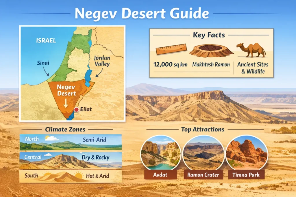
| Size | About 12,000 square kilometers | Shows how large and varied the region is. |
| Main city | Beersheba | Often described as the capital of the Negev. |
| Southern gateway | Eilat | Marks the far southern edge near the Red Sea. |
| Heritage core | Avdat, Haluza, Mamshit, Shivta | These are the essential UNESCO desert cities. |
Where Is the Negev Desert Located?
The simplest answer is that the Negev Desert is located in southern Israel. But the more helpful answer is that it occupies a large portion of the country’s southern half, extending from the Beersheba area down toward Eilat. Britannica notes that the northern boundary is not exact because the Negev blends into neighboring terrain rather than ending at a neat line. That is why many maps depict it as a broad southern region rather than a sharply enclosed shape.
This detail matters because the Negev is best understood as a transition zone. It shifts gradually from more settled and productive land in the north to a much harsher and drier desert in the south. As a result, the landscape is not uniform. One area may appear semi-rural or urban-adjacent, while another may feel open, rugged, and almost lunar in character. For travelers, students, and writers, that geographical diversity is one of the region’s most important traits.
If you are explaining the Negev Desert location in a clean, reader-friendly way, the best phrasing is this: it is a vast arid region in southern Israel that begins near the country’s more developed south-central zone and continues all the way to the Eilat area near the Red Sea. That is the map logic most people need before they move on to climate, landforms, history, and attractions.
Negev Desert Map, Borders, and Size
The Negev is often visualized as an inverted triangle. Britannica describes it as bounded by the Sinai Peninsula on the west and the Jordan Valley on the east, while its northern edge gradually merges into the coastal plain, the Judean Hills, and the Wilderness of Judea. This means the desert does not behave like a fenced-off zone with hard borders. Instead, it functions as a broad, transitional landscape with overlapping ecological and topographic zones.
The region’s size is one reason it feels so diverse. At about 4,650 square miles or roughly 12,000 square kilometers, the Negev is expansive enough to contain multiple landforms, climate zones, and visitor experiences. A single road trip can move from inhabited corridors and agricultural pockets into severe desert scenery without ever leaving the broader region. That is exactly why the Negev performs so well as a pillar topic: it can support content about geology, wildlife, ancient history, conservation, and tourism all at once.
To picture the map more clearly, think of it this way:
The north is where the Negev begins to blend into more settled Israel.
The center contains rocky plateaus, broad wadis, and major geological formations.
The south becomes more sparse, more arid, and more visually dramatic as it approaches Eilat.
The West leans toward Sinai.
The east opens toward the Jordan Valley and the Arava corridor.
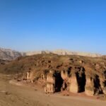
What Makes the Negev Geographically Unique?
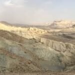
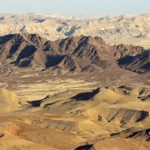
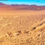
The Negev is not defined by endless dunes. What makes it remarkable is its geological complexity. Britannica describes the area as a land shaped by folds and faults, where limestones and chalks are especially prominent. One of its most distinctive characteristics is the presence of makhteshim, or erosion craters, which are enclosed by high cliffs and formed through the gradual wearing away of folded rock layers.
That is why the Negev does not match the simplistic “flat desert” image many people carry in their minds. Its scenery includes ridges, canyons, plateaus, open basins, and seasonal water channels. The result is a desert that feels sculpted rather than empty. For travel readers, this is a major advantage, because the Negev offers more than open space. It offers visible geological drama that can be experienced from a road, a Lookout point, or a hiking trail.
Makhtesh Ramon and Other Erosion Craters
Britannica identifies Makhtesh Ramon as the largest erosion crater in the region, measuring about 37 kilometers long and up to 8 kilometers wide. It also mentions the Great Crater as another major example of the same landform. These craters expose older rock layers in their floors than those visible around the surrounding cliffs and plateaus, which gives them a layered, time-worn, almost cinematic appearance.
For visitors, this transforms the Negev into a destination for geological tourism. People do not come only to “see a desert.” They come to stand inside a landform that reveals millions of years of earth history. That makes the crater landscape one of the region’s strongest visual and educational assets.
Wadis, Plateaus, and Open Desert Space
The Negev is also shaped by wadis, or seasonal drainage channels. Britannica notes that the rugged Negev is heavily dissected by wadis and that flash flooding is common during the winter rainy season. That point is essential because it shows how dry valleys can suddenly become dangerous during rain events. It also explains why water management mattered so much in both ancient and modern settlements.
The plateaus and open rocky expanses contribute to the Negev’s expansive, windswept character. At first glance, some areas may seem barren, but they are actually rich in ecological and historical significance. The ground is shaped by erosion, water movement, human adaptation, and the survival strategies of specialized desert life.
Negev Desert Climate and Weather
The Negev has a semiarid to arid climate, but rainfall varies significantly from north to south. Britannica notes that in the Beersheba area, rainfall may range from about 200 mm to 305 mm in some years, while the central plateau receives only around 76 mm to 102 mm. At the far southern tip near Eilat, rainfall is negligible. That gradient is one of the most important climate patterns in the Negev: the farther south you go, the less rain you can expect.
This is why the Negev can feel like several deserts in one. The northern part may still support some unirrigated grain farming in favorable years, while the southern portion becomes dramatically harsher and drier. Britannica also points out that the region does not behave like a desert in the simplistic sense many people imagine; rather, it is a zone with semiarid characteristics, variable precipitation, and winter flood risk.
The winter rainy season deserves special attention because it brings flash flooding hazards. Dry wadis may appear harmless, but after heavy rainfall, they can become dangerous very quickly. That is one of the most important travel safety points in any Negev Desert guide, especially for hikers, drivers, and anyone planning to explore streambeds or canyon routes.
Simple Climate Summary
In plain language, the climate works like this:
The north receives a little more rainfall.
The center is drier and more rugged.
The South is extremely dry.
And in winter, sudden rain can send dangerous water through wadis and channels.
Landscape Features You Should Know
The Negev landscape is shaped by rock, erosion, water, and time. Britannica’s geology discussion explains why the region contains cliffs, craters, and plateaus instead of a single flat desert surface. Tourism and park sources also emphasize that this is a place where striking natural formations sit alongside archaeological remains and scenic travel routes.
1. Craters
The makhteshim are the visual signature of the Negev, especially Makhtesh Ramon. These are not meteorite impact craters. They are erosion craters, and that distinction makes them geologically unusual. Their steep walls and exposed rock layers create a dramatic open-air classroom for anyone interested in the deep structure of the earth.
2. Canyons and Stream Beds
Places like En Avdat show how water continues to shape the desert even today. The park describes the Tsin Stream as having carved a deep canyon, while springs feed a brook that flows throughout the year, creating an oasis-like environment. This is one of the best reminders that deserts are not lifeless voids. They are often built around hidden, intermittent, or enduring water sources.
3. Valleys and Cliffs
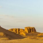
Timna Park offers another powerful example. KKL JNF says it lies about 25 kilometers north of Eilat and combines archaeology, geology, and sweeping views in a landscape shaped by tectonic activity tens of millions of years ago. Its scenery includes angular granite formations and rounded red and white sandstone cliffs, giving the park a vivid and memorable visual identity.
4. Desert Roads and Scenic Routes
This is one of the reasons the Negev works so well as a travel region. Its scenery changes enough to stay interesting, but the area is also connected by major roads and well-known tourist hubs. That combination makes it ideal for road trips, scenic drives, and multi-stop itineraries that blend convenience with adventure.
Plants and Flora in the Negev
The Negev’s vegetation is not lush in the way a forest ecosystem is lush, but it is fascinating in its resilience and specialization. The region is shaped by survival, adaptation, and efficient use of scarce moisture. Israel Nature and Parks Authority says Hai Ramon includes a botanical garden with six habitat types typical of the Negev Highlands, and part of the site functions as a refuge for endangered species. That tells you a great deal about the plant life here: it is specialized, fragile, and remarkably well adapted.
In simple terms, Negev plants survive by conserving water, storing moisture, rooting deeply, or growing rapidly after rainfall before retreating into dormancy during harsher periods. This is why desert botany in the Negev is so intriguing. The plants are not struggling randomly against the climate; they are biologically designed to endure it.
A strong way to describe the flora in your article is this: the Negev Desert’s plant life consists of dry-land specialists found across different habitat zones, from upland terrain to stream valleys, and many of the most interesting examples are best observed in protected reserves rather than at random roadside pull-offs. That phrasing is clear, informative, and search-friendly.
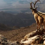
Wildlife in the Negev Desert
The Negev is far richer in wildlife than many people expect. Hai Ramon reports that around 40 species are represented there, including lizards, snakes, turtles, porcupines, hedgehogs, falcons, and sand rats. The site is designed to show how desert animals adapt physically and behaviorally to life in a hot, dry environment.
This is one of the strongest ideas in any Negev article because it changes the reader’s perception. A desert is often imagined as empty, but the Negev is really a specialist ecosystem. Small mammals, reptiles, and birds of prey are especially well adapted to the open terrain. They live here not by accident, but because the environment rewards survival strategies that suit aridity, heat, and scarcity.
En Avdat adds another wildlife dimension. The park refers to itself as “the kingdom of ibex and vultures,” which fits the steep canyon walls, springs, and broad skies of the area. That blend of cliffs, water, and open air creates an ideal habitat for desert wildlife and makes the site especially appealing to hikers, birdwatchers, and photographers.
From a conservation perspective, the key principle is simple: observe wildlife without disturbing it. Desert creatures can be highly sensitive to noise, off-road driving, and litter. In an environment where recovery is slow, even small disruptions can leave long-lasting effects. That is why protected areas in the Negev often rely on managed trails and controlled access.
Human History and Culture in the Negev
The human story of the Negev stretches back thousands of years. Britannica says prehistoric remains are abundant there, including flint arrowheads and stone-age tools. It also notes that the region was pastoral in biblical times. Later, the Nabataeans developed terracing and winter-rain conservation techniques that helped transform parts of the Negev into productive agricultural land.
This is one of the most important truths about the Negev: people did not merely endure it. They engineered systems to manage water, stabilize agriculture, and move trade goods across difficult terrain. The region later became a major granary for the Roman Empire, which shows how valuable desert agriculture could be when supported by the right infrastructure and knowledge.
After the Arab conquest in the 7th century, Britannica says the Negev was largely left desolate and sustained only a small nomadic Bedouin population for more than 1,200 years. Modern development changed the region again, particularly through the growth of kibbutzim in the 1940s, irrigation projects, and the expansion of settlement after 1948.
Today, the Negev carries multiple identities at once. It is a desert region, a heritage region, a modern settlement region, and a tourism landscape. That layered identity is exactly what makes the Negev Desert location such a strong SEO topic. Readers are not only seeking coordinates or a boundary line. They are looking for context, significance, and meaning.
UNESCO Incense Route and Desert Cities
One of the most compelling heritage stories in the Negev is the Incense Route. UNESCO describes it as a long network of trade routes stretching more than two thousand kilometers, used to transport frankincense and myrrh from the Arabian Peninsula toward the Mediterranean. The Negev section includes the four Nabataean towns of Haluza, Mamshit, Avdat, and Shivta, together with related fortresses and agricultural landscapes.
This matters because the Negev is not simply an environmental zone. It is a cultural landscape shaped by movement, commerce, and adaptation. The UNESCO designation reveals that the desert was part of a much larger ancient economy. It was connected to regional and international exchange, not isolated from it.
The heritage sites also make the Negev more compelling for travelers. A road trip through the region can combine archaeology, scenic geography, trade history, and conservation in one itinerary. That is far more engaging than a generic desert stop.
The Four Core UNESCO Towns
Avdat stands out because the Israel Nature and Parks Authority says the ancient Nabataean city sits on a hilltop above the Tsin Stream watercourse in the heart of the desert.
En Avdat adds an oasis-like canyon with springs and wildlife.
Haluza, Mamshit, and Shivta complete the heritage corridor and help explain how trade, water, and settlement worked together in the Negev.
Best Cities and Gateways in the Negev
Any practical Negev Desert travel guide needs to begin with the places people actually use as starting points. The principal gateway is Beersheba, which Britannica identifies as the “capital of the Negev.” It is the region’s most important urban anchor and the place where travelers can find transport, services, accommodation, and a logical point of departure for desert exploration.
The southern anchor is Eilat, located at the far end of the region near the Red Sea. Britannica notes that Eilat sits at the southern tip, where rainfall is negligible, making it both geographically and climatically distinct from the rest of the Negev.
Other important names include Dimona and Arad, both identified by Britannica as planned Negev cities, as well as Midreshet Ben Gurion, which lies near major parks such as En Avdat and is often used as a base for desert-focused travel.
Why Beersheba matters
Beersheba is more than a city near the desert. It is the place that turns the Negev from a huge abstract region into a practical travel area. If you are driving, sightseeing, or planning a longer stay, Beersheba gives the landscape a center of gravity. That is why so many maps and travel guides begin there.
Top Places to Visit in the Negev Desert
If the goal is to create a genuinely useful article, the best places to mention are the ones that combine scenery, access, and story.
1. Makhtesh Ramon
This is the Negev’s signature geological landmark. Britannica says it is the region’s largest erosion crater and one of the most striking examples of the makhtesh landform. Visitors come here for the immense scale, the layered cliffs, and the feeling of standing inside a vast natural basin shaped by time.
2. Timna Park
KKL JNF says Timna Park is about 25 kilometers north of Eilat and blends archaeology, geology, and panoramic scenery in the Red Valley on the edge of the Arava. It also emphasizes the site’s ancient copper-mining history, making Timna one of the best examples of how the Negev combines natural wonder with human history.
3. Avdat National Park
The Israel Nature and Parks Authority describes Avdat as the remains of an ancient Nabataean city on a hilltop above the Tsin Stream watercourse. This is one of the most important heritage locations in the southern desert and an essential stop for anyone interested in the UNESCO story.
4. En Avdat National Park
En Avdat is one of the most beautiful canyon landscapes in the region. The park explains that springs feed a year-round brook and that the site is associated with ibex and vultures. That combination makes it ideal for hikers, photographers, and travelers looking for the oasis side of the desert.
5. Hai Ramon
Hai Ramon is a living desert park where wildlife exhibits, botanical habitats, and environmental education help visitors understand the ecosystem. The site says around 40 animal species are represented there and that the botanical garden reflects six Negev habitats.
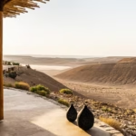
Travel Tips for the Negev Desert
Travel in the Negev is rewarding, but it works best when you are prepared. The biggest challenge is not only heat. It is the combination of distance, exposure, limited water, and sudden weather changes. Britannica notes that flash flooding is common during the winter rainy season, which is why hikers must be careful around wadis and dry channels.
A sensible travel approach is simple:
Carry more water than you expect to need.
Begin hikes early in the morning.
Avoid entering wadis when rain is possible.
Use Beersheba or Eilat as a practical base.
Check park reservation rules before you travel.
Some sites in the region operate with reservation systems. Avdat and En Avdat both mention that reserving ahead helps secure entry and receive visit updates. That is especially useful in a region where not every attraction works like an open roadside stop.
Travel example
A smart one-day desert itinerary could begin in Beersheba or Midreshet Ben Gurion, continue to a heritage site such as Avdat or En Avdat, add a scenic stop in the Ramon area, and then finish near Mitzpe Ramon or Eilat, depending on the direction of travel. This is the kind of structure that makes the Negev feel manageable, even though it is a very large and varied region.
Best Time to Visit the Negev Desert
Because the Negev is hot and dry for much of the year, the most comfortable time to visit is usually during the cooler shoulder seasons. That is a travel-based inference drawn from the region’s arid climate, southward rainfall decline, and flash-flood risks in the winter. In practice, many visitors find spring and autumn more comfortable for hiking and sightseeing than peak summer.
Summer can still be enjoyable, but it demands more preparation: earlier starts, greater water intake, more shade planning, and shorter hiking goals. Winter can also be appealing, but it introduces flood-related hazards in wadis and streambeds after heavy rain. So the best season depends on your priorities: comfort, dramatic conditions, or fewer crowds.
Pros and Cons
Pros
The landscape is remarkably diverse, with craters, cliffs, canyons, and plateaus.
The region blends nature, history, and UNESCO heritage in one destination.
It has strong gateway cities and well-known visitor sites.
It works well for hiking, photography, road trips, and culture-oriented travel.
Cons
Summer heat can be severe.
Winter rain can produce flash-flood danger in wadis.
Some sites require reservations.
Distances between attractions can be long, so planning is essential.
Interesting Facts About the Negev Desert
The Negev is not famous simply because it is empty land. It is famous because it is geology you can travel through. The craters, folded rock formations, and seasonal channels give it a character that is far more compelling than the word “desert” alone implies.
It also has a powerful trade history. The UNESCO Incense Route shows that the region once formed part of a vast system for moving frankincense and myrrh across long distances. That means the Negev was linked to broad economic networks long before modern tourism arrived.
Another important fact is that the region supports both education and conservation. Hai Ramon combines desert wildlife, botanical habitats, and environmental learning in one place. It is a good symbol of how the Negev is experienced today: not only as scenery, but as a living system.
A final fact worth remembering is that Beersheba functions as the practical heart of the region. Britannica explicitly calls it the capital of the Negev, and it gives the desert its most important urban anchor.
Environmental Issues and Conservation
The Negev is beautiful, but it is also vulnerable. Desert ecosystems recover slowly, and water is scarce. That means damage from off-road driving, littering, or heavy foot traffic can persist for a long time. In a place like this, conservation is not a side note. It is part of the visitor experience.
That is why protected sites are so important. Hai Ramon integrates conservation and education into its design. Avdat and En Avdat rely on reservations and managed access. This helps preserve both the land and the heritage value that makes the region special.
There is also a broader balance between development and preservation. Britannica shows how modern agriculture and infrastructure altered the region, while UNESCO and park authorities demonstrate that older landscapes still require protection. The modern Negev is therefore a place of both progress and responsibility.
Why the Negev Desert Matters
The Negev matters because it answers multiple search intentions at once. This is a location. It is a landscape. The Negev is a historical story. It is a wildlife region. This is a UNESCO heritage zone. And it is a travel destination with enough variety to justify more than one stop.
It also matters because it helps explain Israel in a broader sense. The Negev demonstrates how desert land can still support cities, agriculture, archaeology, tourism, and conservation at the same time. That is why it continues to rank for searches such as Negev Desert location, Negev Desert map, Negev Desert climate, Negev Desert wildlife, and Negev Desert travel guide.
FAQs
Yes. The Negev Desert is an arid region in southern Israel. Britannica identifies it as a major southern region of the country with a triangular shape and an area of about 12,000 square kilometers.
Britannica says the Negev is bounded by the Sinai Peninsula on the west and the Jordan Valley on the east. Its northern edge is less exact because it blends into nearby landscapes.
The Negev covers about 4,650 square miles or 12,000 square kilometers.
It is famous for its rocky desert scenery, Makhtesh Ramon, ancient Nabataean heritage, UNESCO-listed desert cities, and major travel stops such as Timna Park and Avdat.
The most comfortable time is usually the cooler season, especially spring and autumn, when outdoor travel is easier, and the heat is less intense. Winter can bring flash-flood risk, and summer can be very hot.
Hai Ramon lists around 40 species, including lizards, snakes, turtles, porcupines, hedgehogs, falcons, and sand rats. En Avdat is also known for ibex and vultures.
The Negev was part of ancient trade and agriculture. The Nabataeans used terracing and winter-rain conservation there, and the Incense Route connected desert cities like Avdat, Haluza, Mamshit, and Shivta to larger trade networks.
Conclusion
The Negev Desert is one of Israel’s most important regions, offering a powerful mix of geography, history, culture, and adventure. Whether you are studying its location or planning a visit, the Negev stands out as a desert that is both beautiful and Historically significant.