Introduction
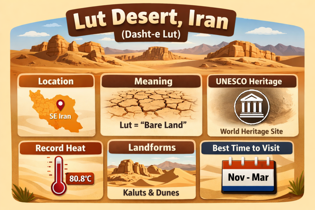
The Lut Desert In Iran, also known as Dasht-e Lut, is one of the most dramatic desert landscapes in the world. Famous for its extreme heat, wind-shaped landforms, and UNESCO World Heritage status, it attracts both researchers and travelers. This guide covers its meaning, location, climate, major landforms, and travel basics in simple English.
Lut Desert at a Glance
| Topic | Key Detail |
| Location | Southeast Iran, inside an interior basin surrounded by mountains |
| UNESCO Status | Inscribed on the World Heritage List in 2016 |
| Size | 2,278,015 hectares with a buffer zone of 1,794,134 hectares |
| Famous Landforms | Kaluts / yardangs, dune fields, stony deserts, salt-filled depressions, wind-shaped ridges |
| Heat Record | NASA reported 70.7°C in 2005; later MODIS analysis reported 80.8°C in 2018 in the broader hottest-surface study |
| Best Travel Season | Late autumn to early spring is generally more suitable because the summer heat is extreme. |
What Is the Lut Desert?
The Lut Desert is a large hyper-arid desert in eastern and southeastern Iran. It is a place where rainfall is extremely limited, the ground can be harsh and barren, and the landscape is shaped by powerful natural forces. Britannica describes it as stretching roughly 320 km from northwest to southeast and about 160 km in width. The eastern side contains a massive dune field, while high ridges and wind-swept corridors mark the western side. In the lowest salt-filled depression, the summer heat and low humidity are said to be among the most intense anywhere on Earth.
What Does “Lut” Mean?
The meaning of Lut is one of the most important semantic angles of the topic. UNESCO explains that in Persian, “Lut” refers to bare land without water and without vegetation. That definition fits the landscape perfectly. The desert is known for its dryness, very low plant cover, and severe environmental conditions.
This meaning matters because many readers do not just want a translation. They want to understand the deeper context behind the name. When someone searches for Lut Desert meaning or Dasht-e Lut meaning, they are usually looking for a connection between the word and the physical character of the place. The name itself is descriptive: it reflects a land where water is scarce, life is limited, and survival is difficult.
That makes the word “Lut” more than a label. It is a compact summary of the desert’s identity. It tells you that this is a region defined by the absence of moisture, minimal vegetation, and extreme aridity. In plain language, the name and the landscape match each other very closely.
For content structure, this is a high-value keyword section because it answers a direct information query in a short, memorable way.
Where Is the Lut Desert Located?
The Lut Desert is located in southeast Iran, inside a vast interior basin that is surrounded by mountains. That geography is not a minor detail; it is one of the biggest reasons the region is so dry. The surrounding mountains block moisture-bearing air masses, which creates a rain-shadow effect. As a result, very little precipitation reaches the desert interior.
Britannica places the desert in eastern Iran and describes it as a long desert system with dune-heavy terrain in the east and ridge-heavy terrain in the west. In practical travel language, many visitors associate the desert with Kerman Province, and desert journeys often begin from Kerman or nearby gateway towns such as Shahdad.
Why does the location matter so much? Because it explains nearly everything else about the desert:
- Why is the land so dry?
- Why is vegetation so sparse?
- Why are the winds so influential?
- Why are the landforms so sharp and dramatic?
- and why the desert experiences such intense temperature stress.
A mountain basin plus hyper-arid climate plus seasonal wind activity create a unique environmental combination. That combination is what makes the Lut Desert one of the most unusual deserts on Earth.
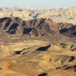
Geography and Physical Size
The Lut Desert is not a small scenic patch of dunes. It is a massive desert system with a broad spatial footprint and several different terrain types within the same protected area. UNESCO states that the World Heritage property covers 2,278,015 hectares, with a buffer zone of 1,794,134 hectares. Those are enormous figures, and they show that the Lut is a large-scale landscape rather than a single isolated feature.
Britannica gives a useful description of the shape. The desert extends northwest to southeast and is roughly 100 miles wide. The eastern section is dominated by dunes and sand seas, while the western section contains high ridges and corridors carved by wind.
This matters for readers because many people imagine a desert as one endless flat plain. The Lut is much more complex than that. It includes:
- dune systems,
- rocky and stony surfaces,
- wind-carved ridges,
- salt-filled lows,
- and highly varied desert terrain.
That diversity is one of the reasons the Lut Desert has become so important in geology, environmental study, and travel writing. It is also a key reason why the topic supports so many search variants and related queries.
Climate and Weather in the Lut Desert
The Lut Desert has a hyper-arid climate, which means the environment is extraordinarily dry. UNESCO explains that the site is in a rain shadow and Experiences very high temperatures. NASA adds that the desert is so remote and severe that conventional weather station measurements are difficult in some areas, which is why satellite data is crucial for understanding its heat patterns.
NASA reported that the Lut Desert ranked as the hottest place in five of seven years during its early satellite study. It also recorded a 70.7°C land-surface temperature in 2005. Later, MODIS-based analysis reported 80.8°C in 2018 in the broader hottest-surface comparison. It is important to understand that these are land-surface temperatures, not normal air temperatures measured at human height.
UNESCO also notes that strong winds sweep across the desert from June to October. These winds move sediment, erode surfaces, and shape the landforms over time. This is not a passive desert. It is a zone of ongoing environmental transformation.
For visitors, the climate is both fascinating and dangerous. It is part of what makes the Lut Desert famous, but it also means that travel requires planning, caution, and respect for the conditions. The same heat and dryness that create the desert’s dramatic identity can become serious hazards for anyone unprepared.
When writing or optimizing content for this topic, climate is one of the strongest semantic fields to include:
- extreme heat
- hyper-arid climate
- rain shadow
- wind erosion
- land-surface temperature
- desert weather
- summer danger
- travel season
These terms fit naturally into the subject and strengthen topical relevance.
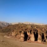
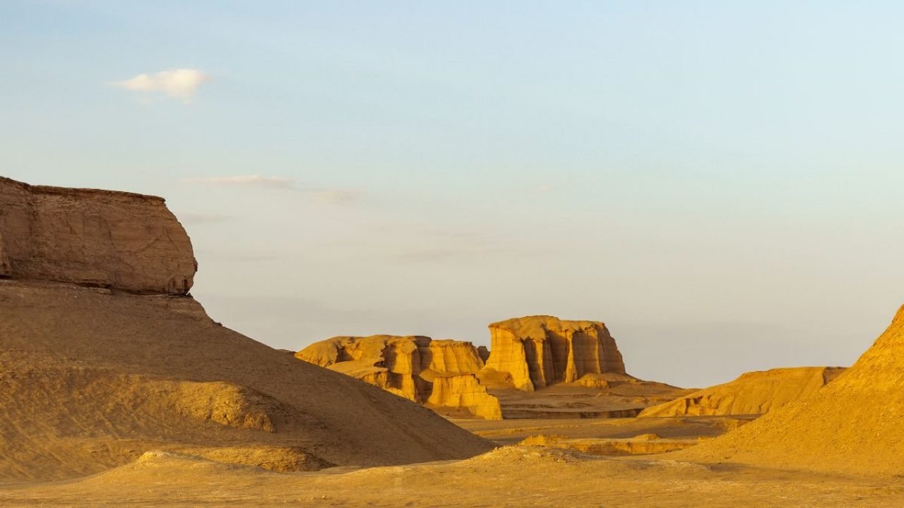
The Main Landforms of the Lut Desert
One of the biggest reasons the Lut Desert is so famous is its landform diversity. UNESCO describes it as an outstanding example of ongoing geological processes. That means the desert is not merely beautiful; it is also scientifically significant because it still reveals how wind, sediment, and time shape landscapes.
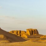
1) Kaluts / Yardangs
The most iconic features of the Lut Desert are the Kaluts. These are giant wind-shaped ridges known as yardangs. UNESCO identifies them as spectacular examples of aeolian yardang landforms. IUGS explains that the yardangs, or kaluts, formed through hydro-aeolian processes in lake sediments and were later enlarged by persistent strong wind action.
IUGS also notes that the Lut contains some of the world’s highest yardangs, with heights exceeding 225 meters, lengths of more than 40 km, and a very large continuous yardang field in the western desert. That is why the Kaluts deserve special attention in any serious article. They are not just a pretty feature for photos; they are a landmark geological phenomenon.
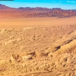
2) Dune Fields and Sand Seas
UNESCO says that huge sand seas cover about 40% of the property. Some dunes rise to 475 meters, which places them among the tallest dunes on Earth. The site includes multiple dune types, such as:
- linear dunes,
- compound crescentic dunes,
- star dunes,
- and funnel-shaped dunes.
This variety makes the desert far more interesting than a simple sand scape. The dune system is complex, layered, and dynamic. It also gives photographers and travelers an unforgettable visual experience.
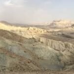
3) Stony Deserts
UNESCO also refers to extensive stony deserts. In these zones, wind removes finer particles and leaves behind stone pavements and gravelly surfaces. The result is a tough, stark environment where rock and gravel dominate instead of soft sand.
These surfaces create a different emotional impression than dunes do. They feel wide, raw, and austere. They also show how wind can clean and reshape a landscape by stripping away the material it does not need.
4) Salt Flats and Salt-Filled Depressions
Britannica notes that the lowest areas of the desert contain salt-filled depressions. These low-lying salty zones contribute to the severe, barren character of the desert. They are part of the reason the Lut often feels so desolate and so empty.
Salt flats are important because they show where water once gathered and later evaporated, leaving mineral residues behind. They are a visible trace of the desert’s long hydrological history.
5) Gandom Beryan
UNESCO materials also mention Gandom Beryan, and the site’s imagery and descriptions highlight its importance. One UNESCO description identifies an extensive black stony desert covering the basaltic Gandom Beryan plateau in the northwest part of the core zone. That makes it one of the named landforms within the broader Lut system.
Together, these features make the Lut Desert a multi-layered natural environment, not a one-dimensional sandy wilderness.
Why the Kaluts Are So Important
The Kaluts are the signature image of the Lut Desert. They are the features most often associated with the region in travel photography, social media, and geoscience writing. But they are important for more than aesthetics.
UNESCO highlights the Kaluts as exceptional yardang landforms, while IUGS explains that wind, runoff, and ancient lake sediments all contributed to their creation. That combination makes them a textbook example of how landforms evolve through environmental interaction.
In simple terms, the process can be understood like this:
- The area once had lake deposits.
- The lake dried out.
- Water runoff cut shallow channels.
- Strong winds widened and deepened those corridors.
- Over time, the ridges became huge sculpted forms.
That is why the Kaluts look like a natural sculpture gallery. They are the result of long-term geological refinement, not random shape-making.
For a pillar article, this section is especially valuable because it connects science, visual interest, and travel search intent. Many people who search for the Lut Desert are really searching for the Kaluts, even if they do not say so directly.
Flora of the Lut Desert
At first glance, the Lut Desert appears almost completely lifeless. UNESCO’s explanation of the word “Lut” itself points to bare land without water and without vegetation. Research on the desert also indicates that much of the area lacks vegetation and that primary producers are absent from most studied regions.
Still, the desert is not entirely plant-free. Some vegetation survives in limited microhabitats where conditions are slightly less severe. These plants may grow where there is occasional moisture, sheltered soil, or small ecological pockets that allow life to persist.
That matters because desert ecosystems often depend on tiny, fragile pockets of biological activity. Even sparse vegetation can play a major role by:
- reducing erosion,
- stabilizing soil,
- supporting insects,
- and creating localized shelter for other organisms.
The right way to describe the flora of the Lut Desert is therefore balanced and accurate: plant life is extremely limited, but not absent everywhere. That wording respects the harshness of the environment without overstating total barrenness.
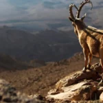
Fauna of the Lut Desert
The Lut Desert is not empty of animals either. A 2018 study on spider fauna in the region documented the first inventory of the desert’s spiders and identified 15 species from 12 families. That is a valuable reminder that even severe desert systems support specialized animal life.
This is an important point for readers because the desert may look uninhabitable, but life in extreme environments often survives through adaptation. In the Lut Desert, the fauna likely includes creatures that can tolerate heat, dryness, and scarce food sources. These may include spiders, insects, reptiles, and other desert-adapted organisms that find refuge in the few more hospitable microenvironments.
The most accurate way to frame the fauna is this: the Lut Desert supports specialized desert wildlife, especially in zones where some vegetation, moisture, or shelter exists. That statement is honest, scientifically cautious, and useful for readers.
For SEO and semantic relevance, this section naturally connects with searches such as:
- Lut Desert wildlife
- Lut Desert animals
- desert ecosystem in Iran
- desert biodiversity
- spider fauna Lut Desert
Human History Around the Lut Desert
Although the Lut Desert itself looks wild and remote, the surrounding region has a long and meaningful human history. Encyclopaedia Iranica notes that the Bronze Age site of Shahdad in Kerman province is important for prehistoric Iranian archaeology. This shows that the desert margins were historically significant long before modern tourism began.
Human history around deserts is often tied to survival, mobility, trade, and settlement at the edges of harsh terrain. People did not live across the whole desert in the same way they lived in greener regions, but they certainly interacted with it. They used water sources when available, built routes across safer areas, and developed cultural life around desert-edge settlements.
For this reason, the Lut Desert is not only a natural wonder. It is also part of a broader historical landscape. When travelers visit the region, they are often moving through a space where geology and human memory overlap.
Shahdad is especially important because it often functions as a gateway for desert access. That gives the desert a travel and heritage dimension that strengthens the article’s usefulness for readers interested in both culture and landscape.
UNESCO World Heritage Status
The Lut Desert was inscribed on the UNESCO World Heritage List in 2016. UNESCO recognized it because the site is an outstanding example of ongoing geological processes and because it contains rare, spectacular desert landforms.
UNESCO’s reasoning is important. The site is not famous only because it is hot or photogenic. It is significant because it demonstrates active processes such as:
- aeolian erosion,
- sediment transport,
- dune formation,
- and yardang carving.
In other words, the UNESCO designation is based on scientific and natural value. The site has global importance because it helps people understand how extreme desert landscapes form and evolve.
This also matters for search intent. Many people search for:
- Lut Desert UNESCO
- Lut Desert World Heritage Site
- UNESCO Iran desert
- Dasht-e Lut heritage site
These are highly relevant keywords because they combine curiosity, status, and trust. UNESCO recognition gives the desert international legitimacy and raises its profile among travelers, researchers, and general readers.
Conservation and Environmental Issues
The Lut Desert is vast, but it is not completely immune to pressure. The IUCN World Heritage Outlook reported relatively few direct threats in 2020, yet it also noted several ongoing pressures, such as:
- grazing,
- firewood collection,
- tourism growth,
- roads,
- and off-road traffic.
This is a crucial section because desert environments can be very fragile. Even though the land may look tough and indestructible, the surface can be damaged easily. A single set of careless vehicle tracks can alter landforms that took hundreds or thousands of years to develop.
That is why responsible tourism is so important. Visitors should understand that the Lut Desert is not a playground for careless driving or irresponsible exploration. It is a protected natural site with immense scientific and ecological value.
A strong article must include conservation because it improves credibility. It reminds readers that the desert is not just a visual attraction or an SEO topic. It is a protected heritage landscape that deserves careful stewardship.
Best Time to Visit the Lut Desert
The best time to visit the Lut Desert is usually during the cooler season. Most travel sources recommend late autumn to early spring, with many pointing specifically to November to March. Some sources even suggest November to December as especially favorable for the Lut region.
This advice makes perfect sense when you consider the climate. Summer heat in the Lut Desert is extreme and potentially hazardous. In contrast, cooler months offer far more manageable conditions for travel, photography, and desert exploration.
A practical travel breakdown looks like this:
- November to February: generally the most comfortable period for many travelers.
- March to early April: still possible and often pleasant depending on the exact route and daily conditions.
- Summer: extremely risky and often unsuitable for relaxed tourism.
This is one of the most useful sections for searchers because it answers direct travel intent. People do not just want facts; they want to know when the desert is realistically visitable.
How to Reach the Lut Desert
In most travel routes, Kerman serves as the main gateway city to the Lut Desert. Shahdad is often the last major stop before entering the desert zones themselves. Travel guides commonly describe overland access from Kerman toward Shahdad as the standard route for organized trips.
This is why the Lut Desert should not be treated like a casual roadside attraction. It is better understood as a planned desert journey that requires transport, fuel, timing, supplies, and often local support.
For visitors, the practical idea is simple: go with a plan. The desert is large, remote, and environmentally harsh. It is not the kind of place where spontaneous off-road wandering is wise.
A safe approach usually includes:
- a reliable vehicle,
- enough water,
- careful route planning,
- and, ideally, a local guide or organized tour.
That makes this section highly valuable for travel-focused readers.
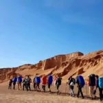
What to Do in the Lut Desert
The Lut Desert is ideal for travelers who enjoy landscapes, geology, photography, desert adventure, and stargazing. It is not a conventional leisure destination in the city-break sense. Instead, it is a place where the environment itself is the experience.
Common activities associated with the Lut Desert include:
- 4×4 desert driving on approved or guided routes,
- photography of yardangs, dunes, and wide horizons,
- stargazing, especially because desert skies can be exceptionally clear,
- short trekking or walking in safer guided areas,
- and cultural stops near Shahdad and the Kerman-region heritage sites.
Each of these experiences is strongest in the cooler season. During the hotter months, travel becomes much more difficult and potentially unsafe.
For readers searching for a “travel guide” angle, this section answers the core question: what is there to do there? The answer is that the Lut is best experienced through scenery, silence, geology, and careful exploration.
Travel Tips for a Safer Visit
A trip to the Lut Desert should be treated like a real desert expedition, not an ordinary outing. The main risks are heat, dehydration, getting lost, vehicle issues, and sudden environmental stress. Because the desert is so extreme, preparation is essential.
A simple safety checklist includes:
- Carry more water than you think you will need.
- Travel in a reliable vehicle with enough fuel.
- Use sun protection such as hats, scarves, and sunscreen.
- Keep navigation tools ready.
- Avoid random off-road driving in fragile zones.
- Travel with a local or experienced guide when possible.
These suggestions are practical because they reflect the actual conditions of the desert. A site like the Lut is beautiful, but it demands respect. Visitors should not underestimate the combination of heat, dryness, and remoteness.
This section also improves SEO usefulness because it directly satisfies questions people ask before they travel: Is it safe? What should I bring? How do I stay protected? Those are high-intent user concerns.
Interesting Facts About the Lut Desert, Iran
The Lut Desert has many interesting features that help it stand out in both science and travel content.
First, NASA reported that it ranked among the hottest places on Earth in five of seven years in one of its early satellite studies. That fact alone has made it globally famous.
Second, UNESCO says the desert contains dunes reaching up to 475 meters and huge sand seas covering around 40% of the property. Those are remarkable figures and help explain why the site is so visually striking.
Third, the desert is not entirely devoid of life. Researchers have documented spiders, and the wider ecosystem supports specialized desert organisms adapted to harsh conditions.
Fourth, the Kaluts are not random hills. They are enormous yardangs shaped by wind and erosion over time, which makes them one of the most fascinating landform systems in Iran.
These facts are useful because they provide memorable, high-value details that readers can recall easily. They also make the article more shareable and more likely to satisfy search intent across multiple related queries.
Why the Lut Desert Is So Popular Online
The Lut Desert is popular online because it appeals to several different types of search intent at once. Some people are drawn to it for scientific reasons. Others are interested in its UNESCO status. Some want to know about its record heat. Others are planning an adventure trip and want practical guidance.
FAQs
NASA reported that the Lut Desert ranked among the hottest places on Earth in satellite land-surface studies, and MODIS recorded 70.7°C in 2005 and later 80.8°C in the broader 2018 analysis. These are land-surface temperatures, not air temperatures.
UNESCO says “Lut” means bare land without water and devoid of vegetation. That meaning matches the desert’s dry and harsh character.
The Kaluts are giant yardangs. They are wind-shaped ridges carved by aeolian erosion over time. UNESCO and IUGS both describe them as one of the desert’s most important landforms.
Yes. UNESCO inscribed the Lut Desert on the World Heritage List in 2016 because of its outstanding desert landforms and active geological processes.
Most travel sources recommend the cooler season, especially November to March, with some saying November to December is ideal for the Lut area. Summer is extremely hot.
Yes. Even though much of the desert has very little vegetation, researchers have documented specialized fauna, including a spider inventory with 15 species from 12 families.
UNESCO materials identify Gandom Beryan as an important part of the desert, including an extensive black stony desert on the basaltic plateau. It is one of the key landscapes inside the Lut system.
Conclusion
The Lut Desert is more than an empty desert. It is a remarkable natural region shaped by wind, heat, and time, with rare landforms and global scientific value. Whether you are interested in geography, heritage, or travel, Dasht-e Lut is one of Iran’s most unforgettable landscapes.