Introduction
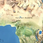
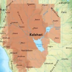
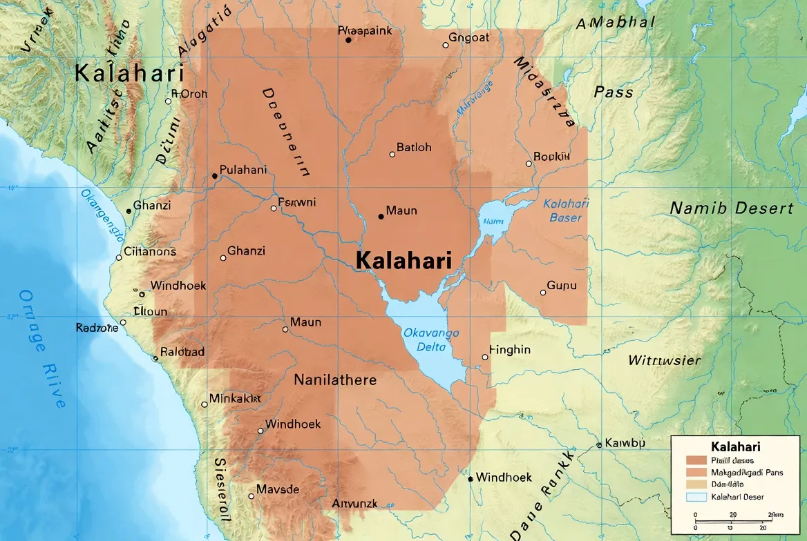
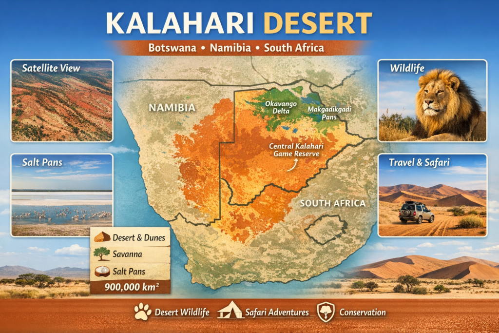
The Kalahari Desert is one of the most fascinating landscapes in southern Africa. Stretching across large parts of Botswana, Namibia, and South Africa, this vast semi-arid region is known for its red dunes, salt pans, grasslands, and remarkable wildlife. Understanding the Kalahari Desert map helps reveal its unique geography, ecosystems, and travel routes, making it an essential guide for researchers, travelers, and nature enthusiasts.
Overview: The Kalahari as a document of landscapes
From a high-level perspective, the Kalahari appears in satellite imagery as a textured document of reds, tans, pale whites, and greens. Where a textual corpus might show recurring n-grams, the Kalahari displays repeating geomorphic motifs: red dune chains, gravel plains, clay pans, and ephemeral wetlands. The “vocabulary” of this landscape includes dunes, salt pans, fossil channels, grasslands, and human settlements. The “syntax” — the way elements arrange across space and time — is governed by climate seasonality, wind-driven sediment transport, and intermittent flooding.
Key summary statistics (a concise metadata block for the landscape-corpus):
- Approximate total area: ~900,000 km² (a very large corpus).
- Core countries covered: Botswana, Namibia, and South Africa.
- Dominant biome/class label: semi-arid sandy savanna.
- Primary geomorphic basin: Kalahari Basin.
- Typical annual precipitation range: ~200–500 mm (varying by subregion).
If we treat the Kalahari as a structured dataset, then a good map is a carefully curated feature table: rows corresponding to spatial tiles (e.g., 1 km² cells) and columns listing attributes — elevation, dune height, soil texture, NDVI (vegetation index), salinity, distance-to-water, protection status, and human presence. With this tabular framing, everything from hydrology to species distributions becomes a supervised or unsupervised learning problem.
Spatial tokenization: breaking the landscape into analyzable units
In NLP, tokenization breaks text into words or subwords. For geospatial analysis, we choose spatial tokens: grid cells, hexagons, watershed units, or object-centric polygons (dunes, pans, river channels). Tokenization decisions affect downstream semantics: large tiles may smooth detail, while small tiles retain local heterogeneity but increase dimensionality.
Common tokenization schemes for the Kalahari:
- Regular raster grid tokens (e.g., 30m or 1km pixels): good for satellite indices and convolutional models.
- Vector tokens (polygons representing dunes, pans, or thornveld patches): preserve object boundaries.
- Hierarchical tokens — tiling at multiple scales — allow multi-scale models akin to hierarchical transformers.
Design choice matters: for wildlife corridors, a 1–5 km token may be appropriate; for fine-scale vegetation studies, a 30m token makes more sense.
Embeddings of place: spatial feature vectors and similarity
Embeddings in NLP convert words or sentences to vectors capturing semantic relationships. Translating this idea, we create spatial embeddings for tiles: vectors that combine spectral signatures (e.g., multispectral bands), textural descriptors (dune ridging), topography, soil properties, and anthropogenic features. Once embedded, spatial tiles can be compared with cosine similarity to find ecologically similar areas across the Kalahari.
Applications:
- Transfer learning: models trained on better-mapped regions can be applied to undersampled parts of the Kalahari using embeddings to find analogues.
- Habitat similarity: identify reserve sites with similar habitat “Semantics” for rewilding or species translocation.
- Change detection: compute differences in embedding space across time to flag unusual shifts, such as the expansion of bare sand or the contraction of wetland signals.
Named-entity recognition (NER) for geography and culture
Standard NER extracts place names, organizations, or person names. For our landscape-document, NER corresponds to extracting named landscape features and cultural groups from heterogeneous sources (satellite metadata, historical accounts, field notes). Entities of interest include protected areas, rivers, pans, settlements, and indigenous cultural groups (for example, the San people).
Why this matters: linking datasets by entities (e.g., connecting a satellite-detected flood in Makgadikgadi to field reports from a specific settlement) requires robust entity resolution. Historical toponyms, local names, and colonial-era labels create noisy mentions — entity linking must reconcile these.
Topic modeling: discovering ecological themes
Topic models (LDA, NMF) discover latent topics in corpora. Spatially, topic models applied to remote sensing-derived features can produce interpretable eco-topics: dune-dominated, pan-dominated, grassland-savanna, wet floodplain, anthropogenic mosaic. Mapping these topic distributions across the Kalahari helps identify transition zones and mixed habitats.
Practical pipeline:
- Feature extraction: spectral indices (NDVI, NBR), texture metrics, elevation, soil salinity proxies.
- Dimensionality reduction: PCA or UMAP to stabilize features.
- Topic model fitting: set several topics to capture major habitat classes (6–12 topics often work).
- Validation: crosswalk topics with field observations and known protected areas.
Topic models often reveal mixed or “fuzzy” zones where grasses and shrubs intermix with dune sands — critical for understanding grazing dynamics and predator-prey interfaces.
Sequence modeling: animal movement as a language
Migration and movement are sequences — like sentences — where each token is a location at a timestamp. Sequence models (Hidden Markov Models, LSTMs, transformers) are natural tools for parsing movement. For example, the seasonal movements of gemsbok, springbok, or predators can be modeled to discover motifs (resting, moving, foraging) and to predict future positions.
Use-cases:
- Corridor discovery: learn regular movement sequences that imply repeated paths (probable corridors).
- Risk assessment: identify sequences that approach human settlement patches or roads.
- Behavioral state inference: latent-state models classify motion into behaviors, helpful for anti-poaching strategies.
Sequence models benefit from high-quality spatio-temporal GPS data, integrated with environmental covariates (rainfall, NDVI, water presence).
A semantic map of landscape features
A well-constructed Kalahari map is effectively a semantic parse of the landscape. Below are canonical categories and their analogous NLP labels:
- Dunes — recurrent n-grams: long, parallel chains, often stabilized by vegetation.
- Salt pans (e.g., Makgadikgadi) — high-frequency motifs with distinctive spectral signatures (bright in visible bands; reflective).
- Fossil river channels (buried/ancient) — historical document references: they reveal paleoclimate and paths of ancient water flow. Examples include channels linked to major regional rivers.
- Seasonal wetlands and the Okavango system — dynamic clauses: their tokens activate only in the wet season (November–March). The Okavango Delta sits at the northern margin of the Kalahari Basin and is a quintessential wet-season transformer.
- Grassland and savanna patches — semantic fields supporting grazing herbivores.
- Wildlife reserves and national parks — entities representing conservation intent (e.g., Central Kalahari Game Reserve, Kgalagadi Transfrontier Park).
- Human settlements and indigenous places — cultural mentions, many tied to the San people’s traditional knowledge.
This semantic map is enriched by satellite time-series that reveal seasonality and interannual variability.
Satellite view and remote-sensing features — reading the spectral script
Satellite imagery — from multispectral sensors to high-resolution optical platforms — provides the raw characters of our landscape corpus. Key remote sensing signals and their semantic meanings:
- Red/near-infrared (NIR) vegetation index (NDVI): green-up in the wet season, proxy for forage availability.
- Shortwave infrared (SWIR): moisture and soil texture indicators; useful for identifying pans and saline soils.
- Thermal bands: surface temperature patterns useful for identifying thermal refugia and nocturnal cooling.
- SAR (radar): penetrates vegetation and senses surface roughness, very useful to map dune morphology and detect buried channels.
When building embeddings, combine spectral indices with temporal summaries (e.g., mean NDVI, seasonal amplitude, date of peak greenness) to create rich vectors representing phenological dynamics.
Climate and seasonality: the temporal grammar
The Kalahari’s seasonality is pronounced. Rainfall is concentrated in the austral summer (roughly November–March), producing a simple temporal grammar: a wet clause followed by a longer dry clause. This wet pulse triggers green-up, ephemeral wetlands, and a proliferation of insects and birds; it is the primary driver of ecological productivity.
Spatial gradient: rainfall generally increases northward across the Kalahari. Southern margins may average ~200 mm/year, central zones ~300–400 mm, and northern reaches up to ~500 mm/year. Temperature profiles show hot summers (often 35–45°C daytime peaks) and cool winters where nighttime thermals can drop below freezing.
Major landscape features: detailed semantic descriptions
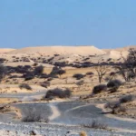
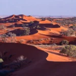
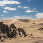
Red dunes — structured motifs
The red dunes are perhaps the Kalahari’s most readily recognized motif. Iron oxide stains the quartz sands, producing the distinctive hue. Unlike many dune systems, Kalahari dunes are often stabilized by grasses and shrubs; their morphology includes long, parallel ridges, rare slip faces, and vegetated interdune corridors. For modelers, dune ridges are linear features extracted via edge detectors and morphological filters on multispectral or LiDAR-derived DEMs.
Salt pans — reflective tokens
The Makgadikgadi Pans are enormous salt crusts — a bright, planar signal in optical imagery. These pans are paleolake beds: fossilized lake deposits that seasonally flood. When inundated, they become breeding grounds for flamingos and migratory birds, and when dry, they form a reflective, near-monochrome surface.
Fossil river channels — hidden syntactic structures
Ancient channels etched into the subsurface leave signatures detectable via surface morphology, groundwater anomalies, and geophysical surveys. These fossil channels preserve a paleoclimate record and often host deeper water tables that provide resilience for vegetation and human use.
Grassland and savanna patches — distributed semantic fields
Grasses dominate large tracts of the Kalahari, particularly where rainfall is higher or groundwater is accessible. These patches form grazing fields that support large herbivore assemblages and their predators. The interaction between grass distribution and dune stabilization is a crucial feedback: vegetation binds sand, which in turn stabilizes plant communities.
Flora and fauna
Flora
- Deep-rooted trees like camelthorn (Vachellia erioloba) reach groundwater and are keystone resources.
- The shepherd’s tree and various acacias fix nitrogen and structure the savanna.
- Tsamma melons and other succulents provide moisture for fauna.
- Grasses dominate herbaceous strata — their phenology tracks rainfall pulses.
Fauna
- Small mammals: meerkats, bat-eared foxes.
- Ungulates: gemsbok, springbok, various antelope.
- Predators: cheetahs, spotted and brown hyenas, and the iconic black-maned Kalahari lions (especially visible across dune-edge hunting grounds).
- Reptiles: diverse lizards, skinks, and vipers adapted to sandy microhabitats.
- Avifauna: ostrich, kori bustard, secretary bird, and large seasonal concentrations of migrants around flooded pans.
Indigenous knowledge and cultural embeddings
Before modern cartography, the San people navigated the Kalahari with cognitive maps built from lived experience: water point locations, edible plant phenologies, animal signs, and rock-art stories that encode seasonal rules. This traditional ecological knowledge (TEK) is a human-language embedding of the landscape and remains invaluable for both conservation and low-impact travel.
When integrating TEK with scientific datasets, respectful co-design and consent are essential. TEK cannot be simply tokenized: cultural context, reciprocity, and data sovereignty must be respected.
Human history and rock art — textual traces of long occupation
The Kalahari contains many rock-art sites and archaeological deposits that are like ancient manuscripts. These records tell of early hunting strategies, climate fluctuations, and social networks. Archaeological stratigraphy, much like document provenance, helps date occupations and infer past ecological states.
Travel, safety, and survival: a procedural manual
Traveling the Kalahari is best treated as a planning problem with constraints: water, fuel, navigational accuracy, and emergency contingencies. Here are essential practical steps framed as procedural tokens (instructions):
- Water budgeting: plan for 4–6 liters per person per day as a baseline; increase in extreme heat or physical exertion.
- Navigation: GPS and satellite navigation are mandatory in remote areas; carry paper maps and learn to read landscape cues.
- Heat management: avoid strenuous activity midday; schedule driving or walking for cooler hours; maintain electrolytes.
- Wildlife interactions: keep safe distances, store food securely, and avoid nighttime walking around camps.
- Communication: satellite phones or emergency beacons are essential for remote travel.
- Local liaison: hire local guides when possible — they provide TEK, route knowledge, and cultural access.
Treat the travel plan as a short program: initialize resources (water, fuel), set safety checkpoints with expected timestamps, and include fail-safe actions (e.g., what to do if the vehicle is immobilized).
Tourism and protected areas: map layers for visitation and conservation
Protected areas act like named entities and labeled spans on a map. Key protected areas include the Central Kalahari Game Reserve (vast interior reserve), the Kgalagadi Transfrontier Park (known for red dune vistas and black-maned lions), and the Okavango system at the Basin’s northern edge.
When producing visitor maps, include the following layers:
- Access routes (graded roads, 4×4 tracks).
- Water sources (perennial boreholes, seasonal pans).
- Fuel stations and resupply points.
- Terrain difficulty and recommended vehicle type.
- Cultural sensitivity zones and community lands.
Design maps for both recreation and risk assessment: mark evacuation corridors and emergency rendezvous points.
Conservation challenges seen through an NLP lens
Viewing conservation issues as classification and trend-detection tasks clarifies priorities:
- Climate change detection: monitor time-series embeddings to detect declines in NDVI amplitude or delayed green-up — signals of productivity loss.
- Desertification classification: apply supervised classifiers to identify areas transitioning from vegetated to bare-sand tokens.
- Overgrazing and land-use change: detect anthropogenic expansion via change in night-time lights, field boundaries, and persistent low NDVI.
- Water extraction impacts: monitor wetland token shrinkage and aquifer drawdown proxies.
- Cross-border coordination: many habitats and wildlife corridors cross political boundaries, necessitating multi-state conservation “entity linking.”
Effective conservation requires integrating satellite-derived indicators with field surveys, community reports, and structured citizen-science inputs.
Interesting facts & semantic curiosities
- The Kalahari is often mischaracterized as a sterile desert, but it is a semi-arid mosaic that supports diverse life — this is a classic case of false negatives in coarse-grained classification.
- The region contains evidence of ancient mega-lakes; paleoenvironmental reconstructions are the “historical corpora” that inform our present-day semantic models.
- Major migration corridors function as long-distance dependencies in the movement “syntax” of ungulates and predators.
- The red color of dunes is an iron-oxide lexical feature: strong, distinctive, and easily picked up by human visual systems and computer vision alike.
- Expansion of arid zones would be a shift in the landscape’s topic distribution — an increase in “bare-sand” topic weight at the expense of grassland topics.
Practical map resources & file types
Researchers and travelers often need downloadable map assets. Useful file types and what they contain:
- High-resolution raster (GeoTIFF): full spectral and elevation bands for high-detail mapping.
- MBTiles: tiled map packages suitable for offline mobile use.
- GPX/KML/GeoJSON: vector tracks and waypoints for navigation and route sharing.
- MBTiles/MBVector: vector tiles for Slippy Map use offline.
- Printable large-format (A0, 300 DPI): for use in field-decision centers or basecamps.
When distributing files, include metadata: coordinate reference system, datum, polygon extents, date of acquisition, and processing lineage.
Environmental threats and mitigation strategies — an evidence-based approach
Threats identified via combined remote sensing, field data, and TEK include:
- Climate variability and decline in mean rainfall: mitigation involves landscape-scale water retention projects (e.g., managed aquifer recharge where feasible), climate-adaptive management of grazing, and monitoring of phenological shifts.
- Overgrazing and habitat degradation: rotational grazing policies, community-led rangeland management, and incentive payments for restoration.
- Unsustainable water extraction: regulate borehole drilling and balance agricultural demands with ecological needs.
- Human-wildlife conflict (HWC): implement early-warning systems, secure livestock enclosures, and compensation schemes linked to measurable reductions in livestock loss.
- Infrastructure fragmentation: design culverts and crossing points for wildlife on major roads; plan new development to avoid key corridor tiles identified through movement sequence models.
Each mitigation is evaluable: specify baseline metrics (e.g., NDVI amplitude, corridor crossing frequency) and apply A/B-style monitoring to estimate effect sizes.
Pros and cons
Treat the “pros” and “cons” as outcome distributions for prospective travelers:
Pros
- Exceptional wildlife viewing probability in certain seasons.
- Unique dune-stabilized red landscapes unmatched elsewhere.
- Opportunities for meaningful cultural exchange with indigenous communities.
- Clear night skies for astronomy and low-light photography.
Cons
- High environmental stress on unprepared visitors (hydration and heat risks).
- Sparse infrastructure and long transit times between services.
- Navigation errors have high consequences in remote tiles.
- Possible negative impacts on local communities if tourism is unmanaged.
A rational traveler frames their trip as an expected-utility calculation: expected enjoyment minus expected costs and risks, weighted by mitigation measures.
FAQs
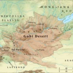
The Kalahari Desert sits in the interior of southern Africa and occupies the central portion of the Kalahari Basin. Geopolitically, it spans significant portions of Botswana, eastern Namibia, and northern South Africa. From a mapping standpoint, its margins are defined by adjacent physiographic systems: the Okavango complex to the north, other deserts and basins to the west and south, and the Zimbabwe plateau to the east.
Estimated at roughly 900,000 square kilometers, the Kalahari is one of the world’s largest semi-arid sand-filled basins. Its spatial extent is vast enough that managing it requires cross-border mapping, coordinated monitoring, and multi-jurisdictional conservation frameworks.
No — the Kalahari is better described as a semi-arid sandy savanna or semi-desert. Because it receives intermittent but meaningful rainfall, supports grasses, shrubs, and large populations of animals, and contains seasonal wetlands and pans, it does not meet the strict climatological definition of an “arid desert” with near-zero vegetation.
The fauna is diverse: small mammals such as meerkats and bat-eared foxes; a suite of grazing ungulates (gemsbok, springbok); large carnivores including cheetah, hyena, and the iconic lions adapted to dune-edge hunting; numerous reptiles; and abundant birds, including both resident birds like kori bustards and seasonal migrants that flock to flooded pans.
Conclusion
The Kalahari Desert is far more than a simple desert. Its diverse ecosystems, rich wildlife, and cultural history make it one of Africa’s most important natural landscapes. By exploring reliable maps, satellite views, and travel information, visitors and researchers can better understand and responsibly experience this extraordinary region.