Introduction
Satellite records show substantial “greening” across parts of the Thar Desert — higher NDVI/leaf-area signals driven by stronger monsoon pulses in some years and by human water use (canals, tube-wells, plantations) in others. But satellite greenness is a signal, not a verdict: it can mean fragile seasonal grass after rains, productive irrigated fields, or water-hungry plantings that deplete aquifers and displace native grasslands. This article explains the evidence, the winners and losers, and practical steps to make greening ecologically and socially sustainable.
Whatdoes “green desert” means
In plain language: “green desert” describes places that appear green in satellite images — higher leaf area index, stronger NDVI/EVI signals — but where that greenness does not equal resilient, biodiverse ecosystems. It’s essential to separate the signal from the semantics.
Think of satellite greenness as the raw token or feature in an NLP model: NDVI is a numerical feature that increases with more leaf cover. But a higher feature value alone doesn’t tell you the class label (healthy ecosystem vs. irrigated monocrop). You must combine it with other features — seasonality, land cover maps, groundwater trends — to infer the true label.
Key distinctions:
- Satellite green = signal (higher plant cover or leaf area detected from space).
- Ecological health = label (diverse native plants, functioning soils, sustainable water use).
- Green desert = false positive — looks good on the satellite feature, but is low in biodiversity, high in water demand, or unsustainable.
So: green ≠ healthy. We need a richer feature set to decide if greening is a net benefit.
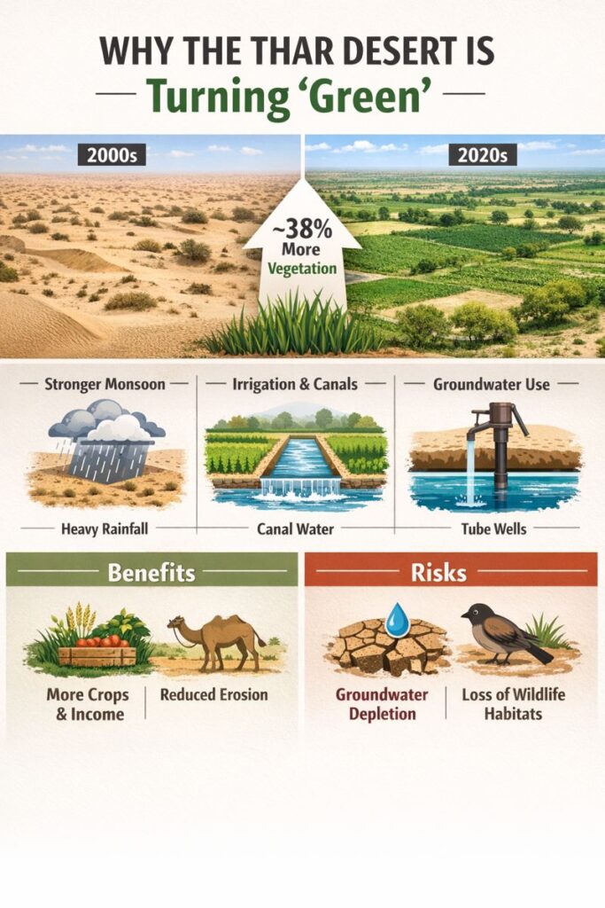
What the data actually shows — the headline numbers and how we measure them
Remote sensing analyses use time-series of vegetation indices (NDVI, EVI, LAI) and classification maps to read the landscape. A headline result widely reported in recent analyses is an approximate ~38% increase in mean vegetation index values over large parts of the Thar between the early 2000s and the 2010s–2020s. That magnitude is substantial: in model terms, it’s a big change in a core feature across many pixels.
Important caveats — data quality and context:
- Spatial heterogeneity: The greening is not uniform. Some canal corridors and irrigated blocks show persistent greenness year-round; many interior desert pixels show strong seasonal greening during the monsoon only.
- Seasonality matters: Time-series decomposition reveals a strong seasonal (annual) cycle. Greening that spikes in JJAS (June–September) is likely rain-driven and may recede in the dry months. Year-round elevated values indicate sustained irrigation or perennial plantings.
- Land-cover confusion: Crops, grasses, shrublands, and tree belts can produce similar NDVI signatures if viewed only by index magnitude. Higher-resolution land-cover classification and ground truthing are needed to disambiguate.
- Water-use inference: Combining satellite greenness with well-monitoring data, gravimetric groundwater trends, or local observations shows that areas with persistent greenness often correlate with groundwater decline over time — a classic human-driven signal.
In short, the NDVI feature has shifted substantially across many Thar pixels, but the downstream inference (is this good?) requires more features.
Why the Thar is greening: drivers explained.
When an NLP model tries to explain why an output changed, it looks for influential features. Here, the main features are climate variables and human water management. We can group causes into two families: climate-driven and anthropogenic-driven signals. Both operate at different temporal scales and spatial patterns, but they also interact.
A. Stronger monsoon rainfall
Feature: annual and interannual variability of monsoon precipitation. The monsoon is the primary training signal for plant growth in arid regions.
Mechanism:
- Heavy JJAS rainfall increases soil moisture and short-term biomass production.
- Satellite time-series show pronounced spikes in Greenness during wet years.
- If monsoon intensity or frequency has strengthened regionally for some years, the NDVI mean across the period will rise — especially if the analysis window includes more wet years than dry years.
Interpretation: monsoon-driven greening is mostly seasonal and contingent on rainfall. It can increase forage and crop opportunities during wet years, but is fragile to dry spells.
B. Groundwater pumping & irrigation expansion
Feature: canal presence, density of tube wells, electrification rates, and cropped area time-series.
Mechanism:
- The Indira Gandhi Canal Project (IGNP) is a major engineered feature that brings surface water into previously hyper-arid zones, effectively changing the local water budget. Where canal water flows, irrigated cropping and tree planting become possible.
- Tube wells (electric or diesel pumps) allow groundwater extraction. As more households and farmers drill wells and adopt pumps, perennial or multiple-cropping becomes feasible, producing year-round greenness that NDVI registers as sustained high values.
- Policy shifts — subsidized electricity, agricultural incentives, or market access — act like model hyperparameters that increase the adoption of water-intensive agriculture.
Interpretation: irrigation-driven greening frequently appears as a persistent elevation in greenness beyond the monsoon season. The risk: if groundwater withdrawal outpaces recharge, the hydrological baseline shifts downward, and the system becomes unsustainable.
C. Land-use change and urban growth
Feature: urban expansion maps, peri-urban vegetation, orchards, and planted parks.
Mechanism:
- Towns and peri-urban villages plant trees, gardens, and irrigated patches that show up as green. Roads and market access make agriculture viable in new locations.
- Settlements often create new micro-habitats — planted trees and gardens — that confer localized greening signals.
Interpretation: this is a patchy contributor to greening but matters for human welfare and local biodiversity when designed thoughtfully.
Combined effect: The overall NDVI increase is a composite of monsoon-driven seasonal spikes and irrigation-driven persistent greenness. A useful analogy: think of NDVI as a multi-dimensional embedding — monsoon pulses shift the embedding seasonally; irrigation shifts the embedding permanently.
Winners and losers — who benefits and who risks losing out
When a feature shifts in a model, some downstream predictions improve, and others worsen. Similarly, greening in the Thar creates winners and losers — socio-ecological actors with different exposure and sensitivity.
Short-term winners
- Irrigating farmers and landowners: Increased moisture and new canal blocks let some farmers plant higher-value crops and increase incomes.
- Local economies: Crop surpluses generate trade, transport, and jobs in market towns.
- Erosion reduction: In places where vegetation stabilizes dunes, wind erosion can decrease, protecting settlements and infrastructure.
At-risk groups and systems
- Pastoralists (herders): Communities that rely on communal grasslands and seasonal mobility face shrinking grazing areas and altered timelines for movement. Loss of open grazing lands reduces resilience for livestock in drought years.
- Grassland specialist species: Birds, small mammals,s and insects adapted to open, sparsely vegetated habitats often decline where grasslands are replaced by crops or tree belts.
- Groundwater-dependent households: Shallow wells and community water points can dry up as deeper pumps extract the aquifer, causing water stress for poorer families who cannot afford deep drilling.
- Smallholders without capital: Wealthier farmers may drill deeper wells and expand irrigated plots, leading to land consolidation and inequality.
A socio-ecological impact assessment should treat greening as a distribution-shifting event: mean vegetation increases, but variance in access and sustainability may also increase.
When greening becomes harmful: “green deserts,” monocultures and ecological traps
“Green” becomes harmful when it is misleading: when the observed signal suggests a healthy system, but the underlying processes degrade ecosystem services. These are the key pathways to harm:
- Native grasslands replaced by water-hungry crops or invasive trees: The substitution reduces habitat for specialist species and decreases local ecological diversity.
- Groundwater depletion: Persistent irrigation without recharge lowers water tables, making the greening temporary or brittle; when water availability falls, newly established crops and plantations may die, and social conflicts over water may emerge.
- Ecological traps: Landscapes that look attractive to wildlife (for example, tree belts that attract birds) but provide poor feeding or breeding resources can reduce population viability.
- Social inequality: Greening benefits those who can invest in pumps and fencing, while marginalized groups lose access to common resources.
In algorithmic terms, a covariate shift (change in water availability) can make previous policies maladaptive. Design interventions to reduce the chance of catastrophic failure when inputs (rainfall, electricity) change.
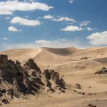
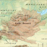
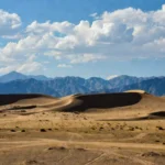
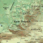
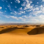
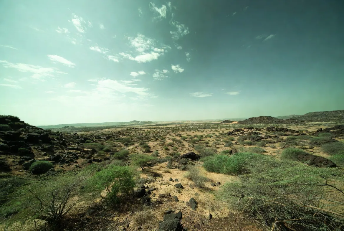
Location and geography — where is the Thar and what does it look like?
The Thar Desert spreads across northwest India (mainly Rajasthan) and into eastern Pakistan. Its landscape is varied:
- Dunes and mobile dunes in some sectors are shaped by wind and occasional vegetation anchoring.
- Stabilized ridges and vegetated interdune areas where shrubs and grasslands hold the sand.
- Salt flats, playas, and ephemeral wetlands that flood in wet years are crucial for seasonal biodiversity.
- Canal-irrigated belts (notably the IGNP corridor) which present a stark land-cover contrast in satellite imagery.
From a spatial-processing view, the landscape is a heterogeneous mosaic of pixels with very different drivers: rain-limited interiors vs. water-enabled canal belts.
Climate and weather patterns are shaping the greening
The Thar’s vegetation dynamics are primarily driven by the South Asian monsoon (JJAS). Key climate considerations:
- Interannual monsoon variability: Wet and dry years produce strong swings in biomass; multi-year trends in monsoon intensity can shift the baseline vegetation signal.
- Climate warming and evapotranspiration: Higher temperatures increase plant water demand and accelerate soil moisture loss, increasing reliance on irrigation for sustained greening.
- Extreme events: Droughts can rapidly reverse monsoon-driven greening; heavy rainfall in short periods can cause localized erosion or salt accumulation.
- Anthropogenic microclimate changes: Tree belts and irrigated areas can modify local humidity and temperature, feeding back into plant growth.
From a predictive modeling standpoint, greening outcomes depend on both forcings (rainfall) and local management (irrigation). Both must be included in any scenario model.
Flora and fauna — native and new assemblages
Flora
- Native grasslands: Dominated by tussock grasses (e.g., Cymbopogon, Aristida species) and drought-tolerant herbs — these support grazing and many specialist species.
- Shrublands and scrub: Species like Prosopis (which can be invasive), Capparis, and Ziziphus occur in different zones.
- Introduced trees and plantations: Eucalyptus, Tectona spp., and other exotic plantings sometimes increase green cover but can be poor habitat for native fauna and can affect hydrology.
- Crop assemblages: Irrigated plots often host cereals, cash crops, orchards, and seasonal vegetables — these show high NDVI during growing periods.
Fauna
- Large mammals: Chinkara (Indian gazelle), nilgai, and other ungulates persist in some protected pockets.
- Grassland specialist birds: Many steppe and grassland birds decline when open habitats are converted to trees or crops.
- Reptiles and invertebrates: Species that require open sand and sparse vegetation face habitat loss when ground cover changes.
Biodiversity outcomes hinge on whether greening supports native assemblages or replaces them with low-diversity stands favoring generalist species.
Human history, culture,s and livelihoods in the Thar
The Thar’s human systems evolved under resource scarcity. Traditional adaptations include:
- Pastoral mobility: Herding livestock across seasonal rangelands provided resilience to temporal variability.
- Rain-fed agriculture: Cropping timed to rains, with seeds adapted to short growing windows.
- Indigenous water systems: Roof cisterns, stepwells, tankas (underground cisterns), and community rules governed scarce water.
Modern drivers — electrification, irrigation, market linkages — changed livelihoods rapidly. Some families diversified their income through market crops; others lost access to common grazing. Policy, infrastructure, and technology reweight the opportunity set for rural households.
Survival tips & travel challenges for visitors
If you plan to visit the Thar:
- Carry adequate water (1.5–3 L per person per day,y depending on activity).
- Avoid midday heat; use morning and late-afternoon hours for walking and sightseeing.
- Dress modestly and protect fromthe sun: hat, long sleeves, sunscreen.
- Use local guides who know where reliable wells and shaded rest spots are.
- Respect private wells and farmland — ask permission before entering agricultural areas.
Challenges: heat, dust, limited mobile network in remote spots, and seasonal road closures after heavy rain.
Tourism — attractions and responsible travel tips
Key attractions:
- Jaisalmer Fort and the old walled city — cultural heritage and architecture.
- Sam and Khuri Dunes — camel safaris and dune camping for scenic sunsets.
- Desert National Park — dunes and wildlife habitat are important for conservation.
- Cultural festivals — like localized desert festivals showcasing music, crafts, and community life.
Responsible travel tips:
- Use licensed operators and local homestays that distribute income locally.
- Avoid off-road driving on fragile dunes and respect wildlife.
- Pack out trash and minimize single-use plastics.
- Support community-led conservation and purchase local crafts.
Sustainable tourism can be a lever to finance conservation and diversify incomes if designed equitably.
Interesting facts
- The Indira Gandhi Canal is one of the largest desert irrigation projects globally and dramatically reconfigured water availability in parts of the Thar.
- Remote sensing picks up leaf area, not species; a dense wheat field looks green on satellite the same way a meadow does if onlythe index magnitude is considered.
- Not all greening is permanent: many interior Thar pixels green strongly in monsoon months and dry out later.
Environmental issues & conservation — turning greening into a net win
To steer greening toward ecological and social benefits, policy and practice must integrate water budgets, biodiversity protection, and community rights. Below are pragmatic steps organized as actionable interventions.
Water governance and regulation
- Permit and monitor well drilling: Regulate uncoordinated tubewell proliferation and require registration to enable basin-scale water accounting.
- Smart electricity and water pricing: Avoid blanket subsidies that encourage wasteful pumping; design tariffs that incentivize efficiency without harming livelihoods.
- Community water budgeting: Encourage water user associations to plan cropping patterns and recharge activities.
Promote efficient irrigation
- Micro-irrigation (drip and sprinkler): These technologies reduce applied water and can sustain production with less aquifer drawdown.
- Scheduling and crop choice: Promote crop calendars and crops suited to local water availability rather than water-intensive cash crops in arid zones.
Protect and restore native grasslands.
- Map and legally recognize grazing commons: Protect key pasturelands via community-based co-management.
- Payments for ecosystem services (PES): Compensate pastoralists for maintaining grazing spaces and biodiversity-friendly practices.
- Rotational grazing regimes: Support practices that maintain grassland productivity and resilience.
Better afforestation choices
- Use native, drought-adapted species: Mixed plantings are better for biodiversity and groundwater than monocultures of exotic trees.
- Avoid tree belts that lower water tables: Choose species and planting densities with local water budgets in mind.
Recharge and hydrological measures
- Percolation tanks and check dams: Usethe canal and runoff water to recharge aquifers intentionally.
- Canal operation for recharge: Manage canal flows with percolation basins and recharge zones in mind.
Monitoring and data integration
- Combine satellite monitoring with community ground-truthing: Remote sensing is powerful, but must be validated locally.
- Early-warning for groundwater stress: Use combined indicators (NDVI persistence + falling water tables) to detect unsustainable greening early.
Social, tenure, and equity reforms
- Secure grazing rights and tenure for pastoralists: Prevent enclosure and unfair appropriation of communal lands.
- Inclusive planning: Ensure smallholders and marginal groups have access to water, markets,s and extension services.
Collectively, these measures aim to convert green signals into resilient, diverse, and equitable landscapes.
Pros & Cons
Pros
- Increased food production and incomes where water is managed sustainably.
- Reduced wind erosion and stabilized dunes in some areas.
- New livelihoods and better infrastructure near canal belts.
Cons
- Groundwater depletion risks long-term water crises.
- Loss of native grasslands and specialist species.
- Widening inequality and reduced communal access for pastoralists.
Quick table — Drivers, Mechanisms, and Practical Solutions
| Driver | How does it cause greening | Practical fixes/interventions |
| Increased monsoon rainfall | Seasonal biomass surge during JJAS | Monitor seasonality; invest in soil and pasture health |
| Canal irrigation (IGNP) | Direct water delivery enabling cropping & tree cover | Manage canal schedules; design recharge zones |
| Groundwater pumping | Year-round greening, but reduces aquifer levels | Regulate drilling; promote micro-irrigation; smart pricing |
| Afforestation/plantations | Tree belts may replace grasslands, low diversity | Use native mixed plantings; avoid exotic monocultures |
| Urban/peri-urban growth | Gardens & parks increase local greenness | Land-use planning; native-species urban green spaces |
FAQs
A: Yes. Satellites show about a ~38% increase in vegetation for parts of the Thar between the early 2000s and the 2020s. But the change is uneven and driven by both rain and human water use.
A: It depends. If greening restores native grasslands and plant diversity, it helps wildlife. If it comes from monocultures or heavy irrigation, it can harm species that need open land.
A: The IGNP brings canal water into the northwest Thar. It has allowed farms and settlements to grow where the desert once dominated. That increases greenness but also changes traditional land uses.
A: Future greening depends on the monsoon, groundwater levels, and policy choices. If groundwater is overused or rains decline, greening could reverse in some places.
Conclusion
The Thar’s greening is a mixed outcome: it can bring livelihoods, stabilize soils, and new opportunities — or it can become a brittle “green desert” that hides groundwater decline and biodiversity loss. Turning the signal into a net win requires Integrated monitoring (NDVI + groundwater + land-use), smarter water governance, native-species restoration, and inclusive policies that protect pastoral commons and smallholders.