Introduction
This page bundles authoritative, easy-to-use map assets for the Thar Desert In Rajasthan — district boundaries (Jaisalmer, Barmer, Bikaner, Jodhpur), the Luni River, Desert National Park, and the Indira Gandhi Canal — delivered as interactive web maps plus printable A4/A3 PDFs and downloadable GeoJSON/KML. Designed for students, travellers, researchers, and planners, the toolkit makes spatial data accessible, reusable, and ready for analysis or field use.
Executive summary
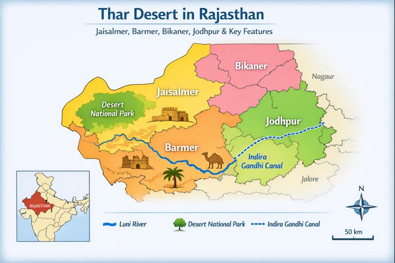
- Geographic scope: Northwest India (mainly western Rajasthan), including Jaisalmer, Barmer, Bikaner, Jodhpur (plus parts of Nagaur, Jalore).
- Primary hydrography: Luni River (main drainage).
- Key engineered feature: Indira Gandhi Canal (IGNP) — major irrigation infrastructure.
- Protected area: Desert National Park (~3,162 km²) near the Jaisalmer–Barmer boundary.
- Common downloads: A4 student PDF, A3 tourist PDF, GeoJSON, KML, SVG locator.
- Core UX: Interactive Leaflet/Mapbox with layer toggles, GeoJSON/KML export, print-to-PDF (A4/A3), and SEO-friendly structured data (FAQ + Article JSON-LD).
Why treat a map page like an NLP pipeline?
An effective map page functions like a well-engineered NLP pipeline:
- Data ingestion = gathering GeoJSON, government shapefiles, and satellite tiles (analogous to corpus collection).
- Preprocessing = coordinate reprojection (WGS84/EPSG:4326), geometry simplification, attribute harmonization (similar to token normalization).
- Feature engineering = deriving dune polygons, irrigated-block masks, and travel-time isochrones (equivalent to n-gram or embedding features).
- Indexing and serving = vector tiles, CDN caching, and map tile pyramids (like optimized inverted indexes or vector stores).
- Export formats = printable PDFs (A4/A3), GeoJSON/KML, and SVG (similar to trained models exporting ONNX/TensorFlow SavedModels).
- Provenance & metadata = README, last-updated stamps, licenses (paralleling dataset metadata and datasheets).
Approaching the Thar mapping project with this mental model ensures clarity, reproducibility, and long-term maintainability.
Target audiences & information intent mapped to outputs
Below is a mapping of audience intents to recommended outputs — think of these as user personas and their required data modalities.
- Students / Teachers
- Output: A4 labeled PDF + SVG locator
- Intent: concise, printable, pedagogical visualization of districts and the Luni River.
- Travellers
- Output: A3 tourist PDF + interactive route layer + campsites
- Intent: route planning, points-of-interest (POI), travel-time estimates.
- Researchers / GIS analysts
- Output: GeoJSON & KML + metadata README + EPSG/CRS notes
- Intent: raw, reusable geometries and attributes for spatial analysis.
- Planners / NGOs
- Output: Time-series land-cover layers + groundwater wells + salinity risk maps
- Intent: impact assessment and planning interventions.
- Developers / Partners
- Output: Embeddable iframe, vector icon pack (SVG), sample Leaflet project
- Intent: reusability and integration into third-party sites.
Core assets to publish
- Interactive map (Leaflet / Mapbox) — the “inference endpoint”. Supports layer toggles, search, and exports.
- Printable PDFs (A4 student, A3 tourist) — “frozen snapshots” or model checkpoints suitable for offline use and printing.
- GeoJSON and KML downloads — the raw datasets; treat them as labeled corpora for downstream analysis.
- SVG locator map — small vector graphic for SEO and fallbacks; behaves like a compressed embedding.
- High-resolution satellite hero image — visually descriptive “cover image” for click-through rate (CTR).
- JSON-LD (Article + FAQ) — structured metadata that helps search engines parse the page (equivalent to semantic annotations).
- Changelog + Data Provenance — dataset datasheet: sources, update cadence, license.
Printable maps & design guidance
PDFs are like fixed-length sequences — optimized for printing at high fidelity and offline use. Produce vector-first artwork (SVG) and convert to high-DPI PDF.
A4 Student Map
Purpose: quick classroom reference.
Canvas: A4 portrait (210 × 297 mm).
What to show:
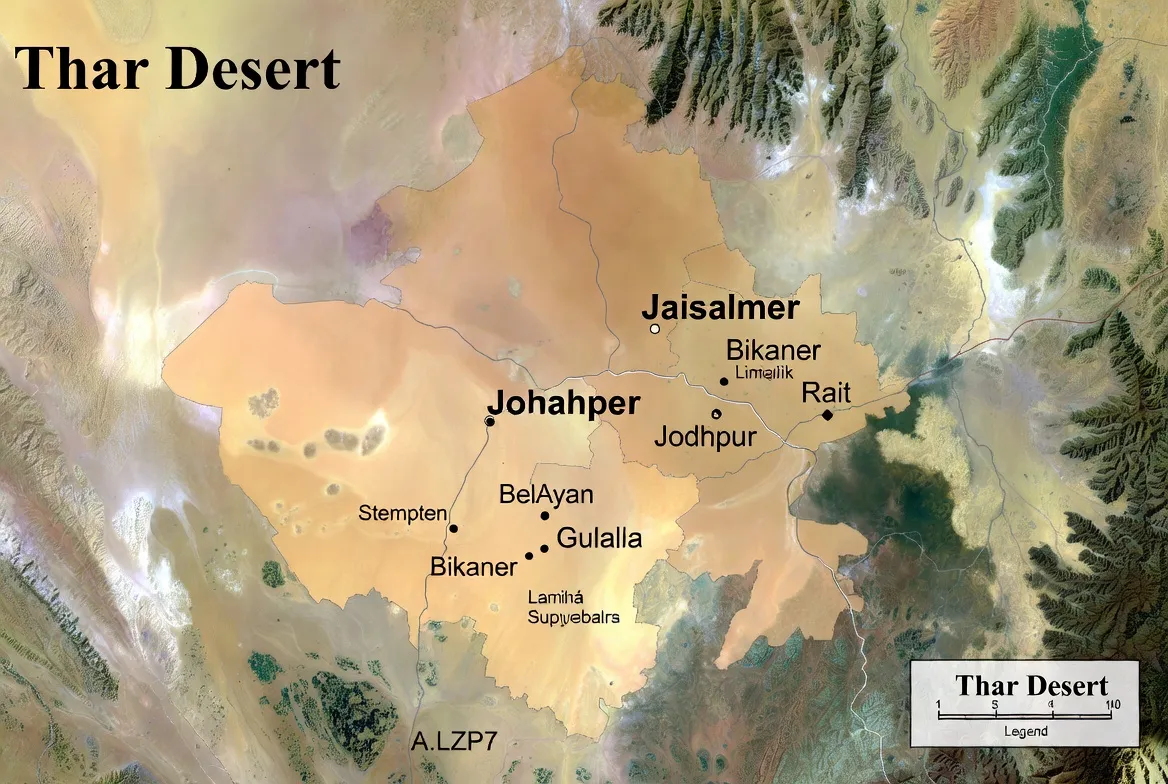
- District boundaries with labels (Jaisalmer, Barmer, Bikaner, Jodhpur — including smaller labels for Nagaur and Jalore, where relevant).
- Luni River (prominent blue polyline).
- Major towns (Jaisalmer, Barmer, Bikaner, Jodhpur).
- Roads: national and state highways.
- Small India locator inset (bottom-right).
- Clean legend and scale bar.
Design: - Sans-serif fonts, 12–16 pt for labels, depending on scale.
- High-contrast palette: gentle fills for districts, solid blue for river.
- Export pipeline: SVG → 300 DPI PDF. Convert fonts to paths for maximum portability.
A3 Tourist Map
Purpose: travel planning and route visualization.
Canvas: A3 landscape (420 × 297 mm).
What to show:
- Attractions (forts, dunes, campsites).
- Suggested route (Jaipur → Jodhpur → Jaisalmer loop) with travel times.
- Airports & railheads.
- Campsites and eco-rated camp icons.
- Small elevation profile for the Sam dune area.
Design: - Use thicker lines for routes, icons for services, and a prominent legend.
- Include fuel/water icon markers and emergency numbers in a safety inset.
- Export as SVG, then PDF at 300 DPI.
SVG locator map & hero imagery
SVG locator alt text (SEO example): “Thar Desert map in Rajasthan showing Jaisalmer, Barmer, Bikaner, and Jodhpur”.
Hero image ALT text: “Detailed Thar Desert map in Rajasthan showing Jaisalmer, Barmer, Bikaner, Jodhpur, Luni River, and Desert National Park.”
Caption sample: “Map of the Thar Desert in Rajasthan with district boundaries, Indira Gandhi Canal (IGNP) and major tourist sites.”
Ensure hero images are compressed for web (serve WebP) and include srcset for responsive sizes.
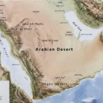
Location, geography & mapping extents
Think of the Thar as a regional ontology with classes and relationships.
Broader spatial facts:
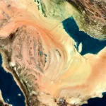
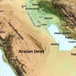
- The Thar Desert lies in northwest India, extending into Pakistan (Cholistan and Sindh).
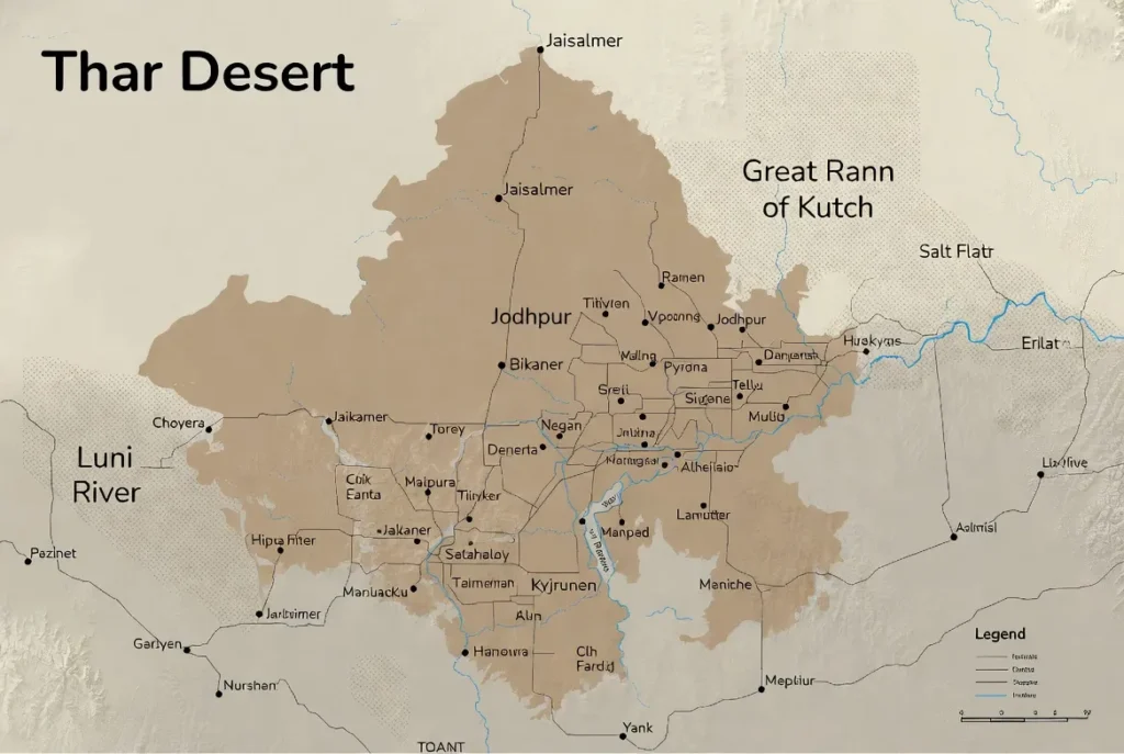
- In Rajasthan, it is concentrated in western districts: Jaisalmer, Barmer, Bikaner, and Jodhpur. Peripheral coverage in Nagaur, Jalore.
- Bounded by the Aravalli range (southeast) and the Rann of Kachchh (south).
Map suggestions for this section:
- District polygons + labels.
- Small inset map of the entire transboundary Thar for context.
- A “layered” legend explaining dataset classes.
Climate & weather overlays
Use raster or vector overlays to show climatic patterns (these behave like temporal features in a time-series model).
Helpful overlays:
- Mean annual rainfall isohyets (bands).
- Monthly rainfall heatmap (seasonal raster).
- Wind rose for dune transport directions (seasonal arrows).
- Mean temperature bands.
- Monthly anomaly layers for exceptional years.
These layers assist users in detecting active dunes vs. vegetated zones and in planning fieldwork.
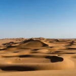
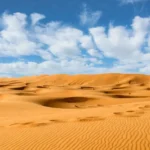
Landscape features & landforms
Map landforms explicitly:
- Dunes: polygon class, ideally with dune_type (barchan, linear) and activity_index.
- Rocky outcrops & plateaus: polygon class.
- Salt flats/playas: polygon class near the Rann of Kachchh.
- Alluvial fans & interdunal plains: polygons with land_use.
- Canal-irrigated blocks: polygons with irrigation_status.
Hydrology & engineered infrastructure
Hydrology deserves special attention due to the Indira Gandhi Canal’s extensive impacts.
Luni River
- Main drainage for the region.
- Map as a clear polyline with basin extent polygon where possible.
Indira Gandhi Canal
- Map alignment as a polyline.
- Overlay irrigated-block polygons showing pre_IGNP vs post_IGNP land cover when time-series data are available.
- Popups for canal include: year_built, major_projects, and impact_summary.
Mapping note: Time-series land cover is highly illustrative for showing greening; consider pre/post satellite composites.
Planner layers
- Groundwater monitoring wells: include if permission and privacy policy allow. Attributes: well_id, depth_m, last_measured.
- Salinity risk: polygons derived from groundwater TDS or soil surveys.
- Pump/lift stations: point features with capacity.
- Irrigation infrastructure: headworks, regulators — points.
Protected areas & biodiversity
Desert National Park (DNP):
- Add a polygon with area_km2, habitats, and main_species.
- Use generalized birdwatching zones and avoid sharing exact nest coordinates for threatened species.
- Provide sensitivity toggles: show/hide detailed wildlife data to protect species.
Fossil parks: mark with POI icons and provide short info on significance.
Ethical mapping rules:
- Never expose the precise locations of endangered species nesting sites.
- Include a “wildlife data use policy,” Explaining how crowd-sourced sightings are handled.
Flora & fauna layers
Map broad vegetation classes:
- dune_sparse_veg
- thorn_scrub (khejri dominated)
- grassland_patches
- canal_cropland
For fauna, show generalized occurrence zones (not precise points) for species like:
- desert fox
- chinkara (Indian gazelle)
- raptors
- historical Great Indian Bustard zones (if relevant)
Include pop-ups with conservation status and links to local groups.
Human history, culture & access constraints
Add cultural layers:
- Generalized historic trade routes.
- Forts and fortified towns (Jaisalmer Fort, Bikaner palaces).
- Pastoral corridors: generalized polygons representing grazing areas.
- Border/security zones: show as advisory polygons with links to permit pages.
Include a small copy urging users to respect local laws and permissions.
Survival kit & safety
On the A3 tourist map, include a “Field Safety” box with:
- Water points & nearest towns.
- Transport hubs: Jodhpur (major), Jaipur (regional), Jaisalmer (local).
- Permit notes for border areas/protected zones.
- Best months to visit: October–March.
- Emergency and park office numbers (if verified).
Tourism routing & Thar loop
Suggested loop: Jaipur → Jodhpur → Jaisalmer (return loop via Bikaner optional).
Stop suggestions:
- Jodhpur (1–2 days): Mehrangarh Fort, markets.
- Jaisalmer (2–3 days): Jaisalmer Fort, Sam dunes.
- Bikaner: palaces and desert museums.
Map extras: - Time-to-drive isochrones (km + estimated driving hours).
- Camel & jeep safari zones (generalized).
- Eco-rated camps: grouped markers.
Interesting map-ready facts
- The Thar is transboundary — extending into Pakistan’s Cholistan.
- Desert National Park is a large protected area preserving dunes and scrub.
- The Indira Gandhi Canal has transformed sections of the Thar into farmland.
These short facts make strong pop-up copy for both interactive maps and PDFs.
Environmental issues & conservation mapping priorities
Map the pressing problems:
- Canal-driven land-use change: visualized via pre/post land cover.
- Groundwater decline & salinity: trend maps from monitoring sites.
- Biodiversity hotspots: generalized zones for sensitive conservation action.
Calls to action on the page should be visible:
- “Download the conservation CSV.”
- “Report a sighting” (with clear terms)
- “Donate to local conservation groups.”
Who uses each map asset
| Audience | Primary asset | Why it helps |
| Students / Teachers | A4 labeled PDF + SVG | Easy to print and use in class |
| Travellers | A3 tourist map + interactive routes | Shows routes, POIs, campsites |
| Researchers / GIS users | GeoJSON / KML + metadata | Direct data for analysis |
| Planners / NGOs | Time-series land cover & groundwater layers | Shows canal impacts and risks |
| Developers / Partners | Embeddable iframe + SVG icons | Easy inclusion on partner sites |
Interactive map vs Static PDF
| Feature | Interactive Map | Printable PDF |
| Interactivity | ✅ toggles, search, popups | ❌ static |
| Mobile-friendly | ✅ responsive | ✅ printable (offline) |
| Data download | ✅ GeoJSON/KML | ✅ PDF only |
| Print quality | depends on tiles | ✅ high-res, vector |
| SEO benefit | ✅ dwell time & embeds | ✅ fast-loading (SVG) fallback |
Pros & cons
Pros
- Meets diverse user intents.
- Increases dwell time with interactive content.
- Authority via source citation and data provenance.
Cons
- Interactive features require hosting and resource management.
- Some governmental GIS layers have licensing or access constraints.
- Time-series hydrology/groundwater data may be scarce.
How we made these maps
Always include a concise data provenance panel:
- OpenStreetMap — towns, roads.
- State government GIS — official district boundaries and canal alignment, where available.
- Protected-area datasets — Desert National Park boundaries.
- Satellite imagery — used to validate irrigated blocks and land cover changes.
Include links or references to each source and the last_updated date.
Implementation-ready checklist
- Collect GeoJSON: districts, Luni River, IGNP canal.
- Create vector tiles & host.
- Build a Leaflet map with a layer switcher, geocoder, and download tools.
- Create SVG templates for A4/A3; export to PDF.
- Add JSON-LD and SEO metadata.
- Test accessibility and cross-device rendering.
- Publish with changelog & download README.
FAQs
A: Yes — the page provides GeoJSON/KML files for district boundaries and river polylines. Check the “Downloads” panel for README and licensing.
A: Yes — the Thar is transboundary and continues into Pakistan’s Cholistan and Sindh regions. Include cross-border maps for full studies.
A: Absolutely — IGNP is a separate toggle. We show the canal alignment, irrigated-block overlays, and notes on its ecological impacts.
A: Jaisalmer, Bikaner, and Jodhpur (with Barmer often included) form the core desert triangle used in travel and local descriptions.
Conclution
Whether you need a classroom-ready A4, a route-planning A3, or raw GeoJSON for GIS work, these maps and downloads provide reproducible, provenance-backed resources to study and navigate the Thar. Please check the data Provenance and licensing panel before use, and consider contributing corrections or field updates to keep the dataset current and trustworthy.