Introduction
This short guide condenses the essentials for navigating and mapping the Gobi Desert — from dune dynamics at Khongoryn Els to the fossil-rich Flaming Cliffs (Bayanzag) and the Nemegt Formation. It explains what to pack, which layers and file formats (A0 PDF, GPX/KML/GeoJSON, hillshade) matter most, and how to use device-ready map packs and field notes to travel safer and lighter.
Quick facts
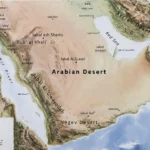
- Area: ≈ 1,295,000 km².
- Countries: Mongolia and China.
- Climate: cold desert with large seasonal swings — icy winters and hot summers.
- Best times to visit: late spring (May–June) and early autumn (Sept–Oct).
- Top sites: Khongoryn Els, Flaming Cliffs (Bayanzag), Nemegt Formation.
(If you want to skip straight to product-ready elements, jump to the “Navigation & map-pack details” and “How to design the downloadable A0 map pack landing page” sections.)
Why a solid map pack matters
The Gobi is a highly heterogeneous, often trackless landscape. Reliable maps and device-ready route packs convert uncertainty into navigation confidence. They provide planning-scale visuals (A0 overview), last-mile verification (satellite overlays), and robust device files (GPX/KML/GeoJSON) you can load into Garmin, OsmAnd, Locus, or desktop GIS. Without layered maps—base map, vector track layers, hillshade, and recent imagery—routes can go wrong quickly: tracks shift, seasonal salt pans flood, and dune corridors become impassable.
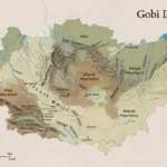
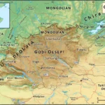
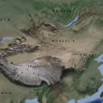
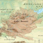
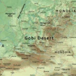
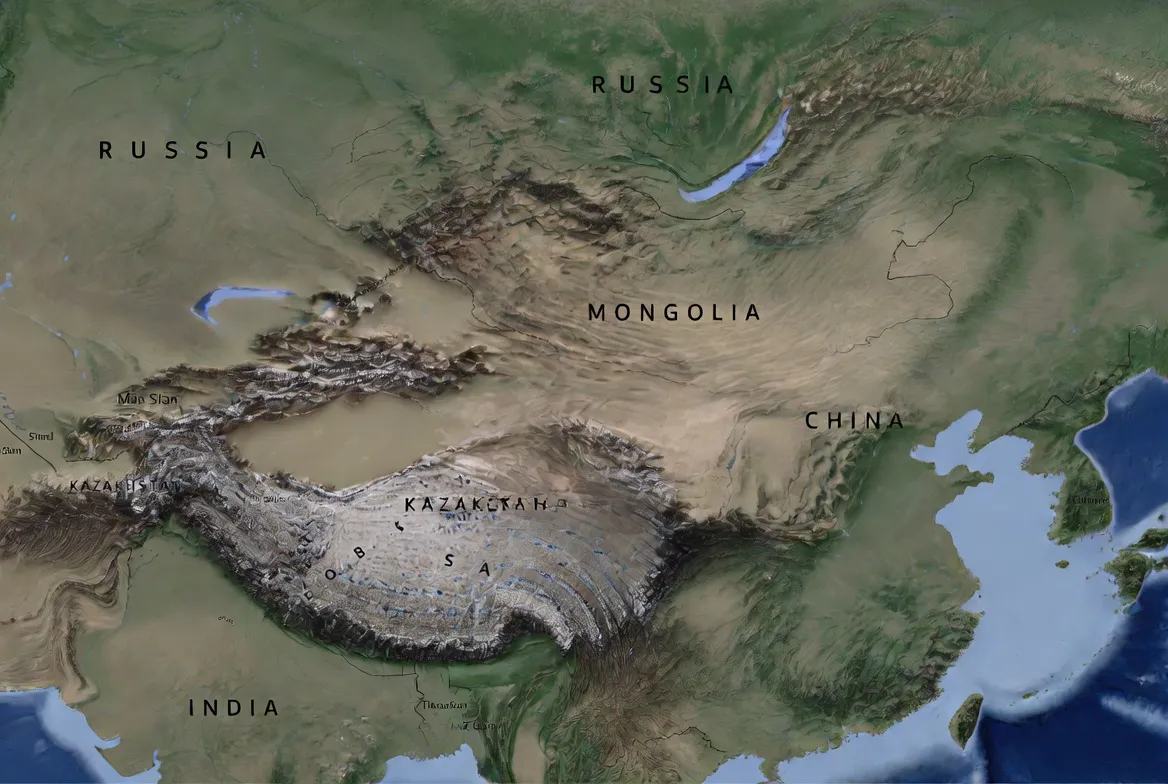
Geography & location — the big picture
The Gobi stretches across southern Mongolia and parts of northern China. It’s the size of a small continent and includes a wide range of landforms: hard rock plateaus, gravelly deserts, dispersed dune fields, drainage channels (khads), and badlands with steep, fossil-rich outcrops. Because elevation commonly sits between ~900–1,500 m, temperatures swing more widely than in low-elevation deserts; nights can be biting cold even in summer.
Major implications for mapping and route planning:
- Plan fuel and supplies with conservative margins (stations are sparse).
- Use hillshade and contours to identify likely soft-sand depressions and safe passes.
- Always include local access notes: seasonal restrictions, protected zones, cultural sites.
Main landscape types and mapping rules
Each landscape type demands specific map layers and metadata. Below are the common types and the practical map elements you should include for each.
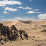
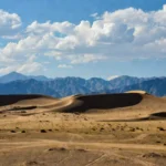
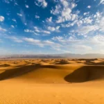
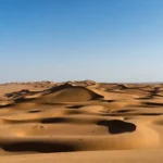
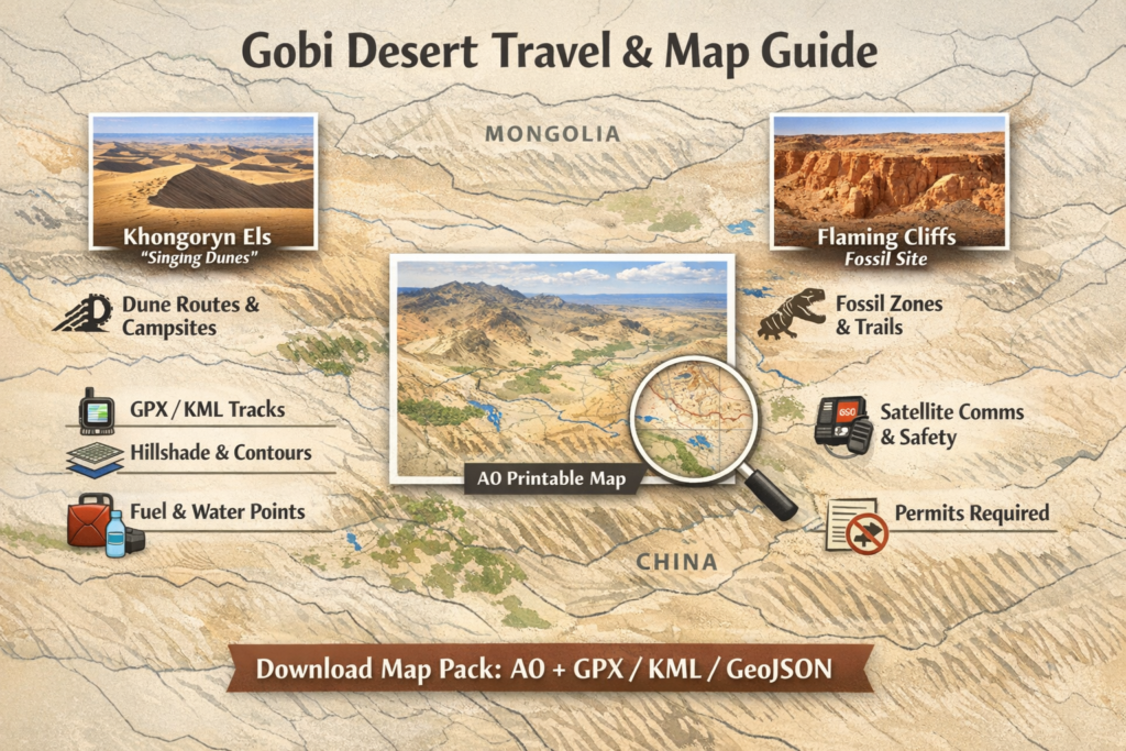
Khongoryn Els — dune systems
Khongoryn Els (commonly called the “Singing Dunes”) is a classic large dune field with migrating sand and localized campsites. Dune tracks change with wind seasons.
Map elements for dunes
- Sand stability polygons (where dunes shift vs. stable margin).
- GPS waypoints for safe entry/exit and Permanent campsite coordinates.
- Soft-sand hazard buffers (user-configurable).
- Photo-point waypoints (for user guides and repeat photography).
Routing rules
- Avoid crest crossings unless you can assess sand depth and vehicle capability.
- Provide bypass tracks and multiple options for approach/egress.
- Add slope/gradient warnings for long sand climbs.
(For Khongoryn Els specifics and travel logistics, see official park notes and travel operators’ pages. )
Rock plateaus & badlands
Badlands like the Flaming Cliffs are paleontologically important and often fragile.
Map elements
- Protected boundary polygons and legally required visitor zones.
- Footpath/track categories (paved/graded / 4×4 / foot).
- High-resolution hillshade and 5–10 m contours for cliffs and gullies.
Rules
- Mark access points for licensed guides only.
- Flag fossil-protection rules prominently in READMEs and field notes.
Salt pans & playas
Salt pans look drivable, but can be impossible after rain.
Map elements
- Seasonal accessibility notes and rainfall-sensitivity tags.
- Alternate bypass routes with elevation and substrate notes.
River valleys & khadags
These can provide natural routes, but they also pose risks from sediment and flash floods.
Map elements
- Crossings with slope and sediment notes.
- Flood-prone buffers and seasonal flow indicators.
Climate & timing your trip
The Gobi is a cold desert: think huge diurnal ranges. Prepare for extremes.
Seasons
- Winter: Very cold (can be severely below freezing).
- Summer: Hot days; strong sun and low humidity.
- Best windows: May–June and Sept–Oct (milder, more predictable roads).
Practical tips - Layering is essential (insulation plus sun protection).
- Allow buffer days for weather delays or track closures.
Flora, fauna & paleontology — what you may see
The Gobi supports an adapted ecology of dwarf shrubs, saxaul, and rare megafauna like wild Bactrian camels and the critically endangered Gobi bear. Many fossil-rich formations—including the Djadochta and Nemegt—have yielded world-class finds. The Flaming Cliffs (Bayanzag) are famous for the first scientifically described dinosaur eggs, uncovered by early 20th-century expeditions. Always respect fossil protection laws and work with licensed guides if you require paleontological access.
Practical planning — vehicles, fuel, water, and safety
For remote loops and dune approaches, a competent 4×4 is strongly recommended. Prepare spares and recovery gear, and treat water and fuel as strategic resources.
Vehicle & spares
- 4×4 with high clearance recommended for off-pavement travel.
- Two spare tires, heavy-duty jack, repair kit, spare belts/filters.
Recovery gear
- Tow straps, soft shackles, shovel, traction boards, and air compressor.
Fuel
- Carry enough fuel for large detours and unexpected waits. Plan caches if possible.
- Map field notes must list fuel stops, opening times, and alternative options.
Water & food
- Carry far more water than you think you’ll need.
- Include contingency rations and basic water purification.
Comm & emergency
- Satellite comms (Iridium, Inmarsat), SPOT/PLB recommended.
- Share detailed route with a reliable contact; include ETAs and contingency exits.
Permits & rules
- Some areas require permits and guided access.
- Fossil removal without permits is illegal — always heed heritage rules.
Navigation & map-pack details — technical checklist
A professional map pack should be modular and device-friendly. Below is the technical checklist you can use to produce or audit a Gobi map pack.
Core printable & preview files
- A0 printable PDF (300 DPI) — full extent overview, layered for color printing.
- Inset A2/A4 PDFs — high-interest zones (dunes, Flaming Cliffs, Nemegt Basin).
- Preview PNG — fast-loading preview for landing pages.
Vector & track files
- GeoJSON: roads, tracks, settlements, POIs as separate layers.
- KML: Google Earth and quick-display version.
- GPX: route packs (waypoints, tracks, routes) ready for navigation units.
Elevation & imagery
- Hillshade rasters (e.g., SRTM-derived) for terrain reading.
- Contour layers (10–30 m intervals depending on area).
- Recent satellite imagery overlay tiles for last-mile confirmation.
Field notes & metadata
- Field notes PDF: fuel list, permits, emergency contacts, local service info.
- Checksums (MD5 or SHA256) for each download to verify integrity.
- README with step-by-step device load instructions (Garmin, OsmAnd, Locus).
Licensing & ethics
- A short license that states permitted uses and prohibits illegal fossil collection.
- A conservation/low-impact travel statement on every page.
Sample 3-day self-drive loop
Below is a text-based planning outline. Don’t use it as a final navigation tool. Convert to GPX with verified coordinates and cross-check with recent satellite imagery before travel.
1 — Dalanzadgad → Khongoryn Els
- Final supplies & fuel in Dalanzadgad (last major service hub).
- Drive to dune fringe campsite; sunset climb.
2 — Khongoryn Els → Flaming Cliffs (Bayanzag)
- Sunrise photography, morning dune activities.
- Drive east; use mapped bypasses to avoid soft-sand corridors. Guided fossil-interpretation option.
3 — Flaming Cliffs → Dalanzadgad via alternate corridor
- Morning exploration of badlands. Check the vehicle, fuel, and return to Dalanzadgad.
Notes: Plan waypoints for camp, fuel points, alternate exits, and emergency evac coordinates. Produce elevation profiles to highlight high passes or steep gullies.
How to design the downloadable A0 map pack landing page
A good landing page converts interest into downloads. Use the following elements to increase CTR and trust.
Hero headline: “Gobi Desert Map Pack — Printable A0 (300 DPI) + GPX/KML/GeoJSON.”
Short blurb: One or two lines that highlight concrete benefits: printable overview + device-ready GPX + hillshade layers + field notes.
Preview gallery: Show A0 preview and zoomed insets (Khongoryn Els dune inset, Bayanzag badlands inset).
Features list: Use bullets for quick scanning: A0 PDF, inset sheets, GeoJSON, GPX loops, hillshade, README, checksums.
CTA button: “Download Pack — ZIP with A0 PDF & GPX” (place it above the fold and replicate at the bottom).
FAQ section: Short answers for printing tips, refund policy, and licenses.
Technical instructions: Expandable modal blocks for Garmin/OsmAnd/Locus load steps.
Sample GPX snippet: Show a short example (to reassure technical users).
Support & updates: Add a version history (v1.0, v1.1) and date stamp for trust.
Download checklist & file-format primer
Before publishing or buying, ensure the pack contains:
- A0 PDF (300 DPI) + preview PNG.
- GeoJSON with separate layers (roads, tracks, settlements, POIs).
- KML for Google Earth.
- GPX files separated by route type.
- Hillshade raster (GeoTIFF).
- Contours (GeoJSON or shapefile).
- README and field notes PDF (fuel, permits, ethics).
- Checksums.
- Clear licensing terms.
Why checksums? To confirm file integrity and avoid corrupted downloads.
Low-impact travel & conservation rules
The Gobi’s ecosystems and fossil sites are fragile. Respect these rules.
- Stay on established tracks. Off-track driving damages vegetation.
- Do not collect fossils without permits. Fossils are protected.
- Respect local communities; ask before photographing people.
- Pack out all trash and minimize single-use plastics.
- Support local guides and businesses.
Maps, apps & quick loading tips
Garmin: Copy GPX or use BaseCamp. For vector overlays, follow device-specific steps.
OsmAnd / Locus: Import GPX or KML; use offline vector packs for better performance.
Google Earth / Desktop GIS: KML quick view, GeoJSON/shapefiles for deeper GIS work.
Sample GPX waypoint snippet
<wpt lat=”43.44210″ lon=”103.12345″>
<name>Khongoryn Els Camp 1</name>
<desc>Safe dune-edge camp. Water: none. Access note: avoid dune crest at night.</desc>
</wpt>
(Use verified coordinates from field surveys or your map pack.)
Safety & emergency planning
- Share your route with a trusted contact.
- Carry satellite comms and PLB.
- Have local emergency numbers and nearest hospital/airstrip addresses.
- Check domestic flight schedules (many visitors reach Dalanzadgad from Ulaanbaatar).
Short comparison table: Major site types
- Khongoryn Els: Dune camping, moderate difficulty (soft sand); best May–Oct.
- Flaming Cliffs (Bayanzag): Paleontology and photography; easy-moderate access; protect fossil areas.
- Nemegt Formation: Remote fossil localities; hard access; best supported by scientific expedition routes.
Interesting facts
- The Flaming Cliffs yielded the first scientifically described dinosaur eggs during early 20th-century expeditions.
- The “singing” dunes at Khongoryn Els sometimes produce a humming sound due to sand grain interactions.
FAQs
A1: Yes — quality map packs provide an A0 300 DPI full-extent PDF plus inset sheets and device-ready vector/GPX files. Look for packs that include checksums and field notes.
A2: Late spring (May–June) and early autumn (Sept–Oct) usually offer the mildest conditions and the most predictable road windows.
A3: Many fossil areas are visitable with licensed guides, but fossil collection without permits is illegal. Follow heritage rules.
A4: For off-pavement routes and dune approaches, a 4×4 is strongly recommended. On main paved corridors, a standard vehicle may sometimes suffice, but expect long gaps between services.
Conclusion
Whether you plan a short loop from Dalanzadgad or connect through Ulaanbaatar, prioritize layered maps, conservative logistics, Verified checksums, and satellite comms. Respect local permits and fossil-protection rules across Mongolia and China — the best trips are the ones that leave the landscape intact.